Snow Model Adjustment Methods at NOAACBRFC Stakeholder Forum
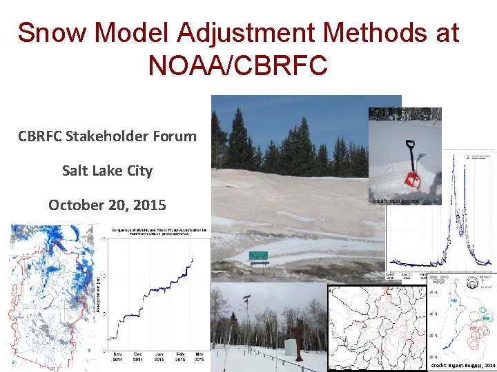
Snow Model Adjustment Methods at NOAA/CBRFC Stakeholder Forum Salt Lake City October 20, 2015 Credit: CSAS/CODOS Credit: Bryant-Burgess, 2014

Operational CBRFC Snow Model Operational Snow Model at CBRFC: SNOW 17 Operational CBRFC Snow Model: SNOW 17 • minimum inputs and computational power needed Overview of Methods • Current Operational Adjustment Method (SWE) manually calibrated at CBRFC using 1981 -2010 historical data • Research/Exp erimental Methods (SWE, melt rate) temperature-index model (air temperature used as proxy for energy/radiation) • forecasts snowmelt pretty well under near-normal conditions of the calibration period • doesn’t do so hot when conditions deviate from near-normal – adjustments needed Questions and Comments Water output from SNOW 17 is then input to the soil moisture model (Sac-SMA) 2

Snow Model Adjustment Methods Operational CBRFC Snow Model: SNOW 17 How can we adjust SNOW 17 states computations in hopes of making better snowmelt-driven streamflow forecasts? Overview of Methods Adjust the SNOW 17 SWE Adjust the SNOW 17 melt rate • Impacts: forecasted flow and forecasted runoff volumes • RFC speak: “make a WECHNG mod” • Modify the SWE using: Ø Closely QC’d SNOTEL precipitation data Ø Statistical relationships between SNOTEL SWE obs and SNOW 17 simulated SWE Ø fractional snow-covered area (f. SCA) data from remote sensing (from NASA/Jet Propulsion Lab) • Impacts: forecasted timing of streamflow • RFC speak: “feed modified input temperatures to SNOW 17” • Modify the melt rate using: Ø “dust on snow” data from remote sensing (from NASA/Jet Propulsion Lab) Current Operational Adjustment Method (SWE) Research/Exp erimental Methods (SWE, melt rate) Questions and Comments 3
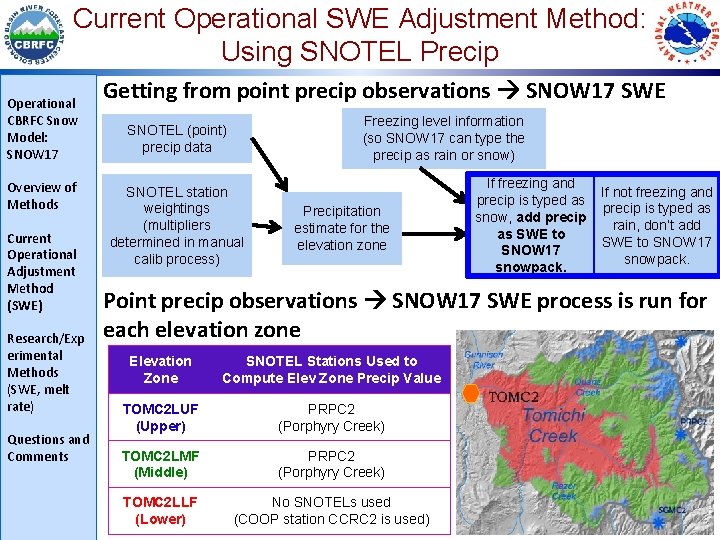
Current Operational SWE Adjustment Method: Using SNOTEL Precip Operational CBRFC Snow Model: SNOW 17 Overview of Methods Current Operational Adjustment Method (SWE) Research/Exp erimental Methods (SWE, melt rate) Questions and Comments Getting from point precip observations SNOW 17 SWE Freezing level information (so SNOW 17 can type the precip as rain or snow) SNOTEL (point) precip data SNOTEL station weightings (multipliers determined in manual calib process) Precipitation estimate for the elevation zone If freezing and precip is typed as snow, add precip as SWE to SNOW 17 snowpack. If not freezing and precip is typed as rain, don’t add SWE to SNOW 17 snowpack. Point precip observations SNOW 17 SWE process is run for each elevation zone Elevation Zone SNOTEL Stations Used to Compute Elev Zone Precip Value TOMC 2 LUF (Upper) PRPC 2 (Porphyry Creek) TOMC 2 LMF (Middle) PRPC 2 (Porphyry Creek) TOMC 2 LLF (Lower) No SNOTELs used (COOP station CCRC 2 is used)
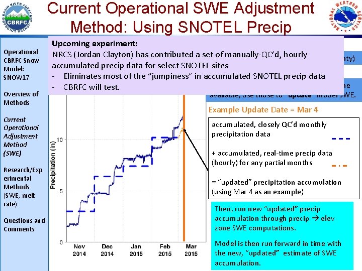
Current Operational SWE Adjustment Method: Using SNOTEL Precip Operational CBRFC Snow Model: SNOW 17 Overview of Methods Current Operational Adjustment Method (SWE) Research/Exp erimental Methods (SWE, melt rate) Questions and Comments Upcomingand experiment: Building updating the SNOW 17 -simulated snowpack NRCS Clayton) has raw contributed a set of manually-QC’d, hourlyof uncertainty) Daily(Jordan model uses real-time, accumulated precipitation – jumpy (source accumulated precip data for select SNOTEL sites - Eliminates most of the “jumpiness” in accumulated SNOTEL precip data So, when QC’d monthly precip obs become - CBRFC will test. available, use those to “update” model SWE. Example Update Date = Mar 4 accumulated, closely QC’d monthly precipitation data + accumulated, real-time precip data (hourly) for any partial months = “updated” precipitation accumulation (using Mar 4 as an example) Then, run new “updated” precip accumulation through precip elev zone SWE computations. Model is then run forward in time with the new, “updated” estimate of SWE accumulation.
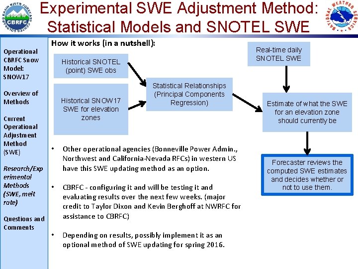
Experimental SWE Adjustment Method: Statistical Models and SNOTEL SWE Operational CBRFC Snow Model: SNOW 17 How it works (in a nutshell): Historical SNOTEL (point) SWE obs Overview of Methods Current Operational Adjustment Method (SWE) Research/Exp erimental Methods (SWE, melt rate) Questions and Comments Historical SNOW 17 SWE for elevation zones • Statistical Relationships (Principal Components Regression) Other operational agencies (Bonneville Power Admin. , Northwest and California-Nevada RFCs) in western US have this SWE updating method as an option. • CBRFC - configuring it and will be testing it and evaluating results over the next few weeks. (major credit to Taylor Dixon and Kevin Berghoff at NWRFC for assistance to CBRFC) • Depending on results, possibly implement it as an optional method of SWE updating for spring 2016. Real-time daily SNOTEL SWE Estimate of what the SWE for an elevation zone should currently be Forecaster reviews the computed SWE estimates and decides whether or not to use them.
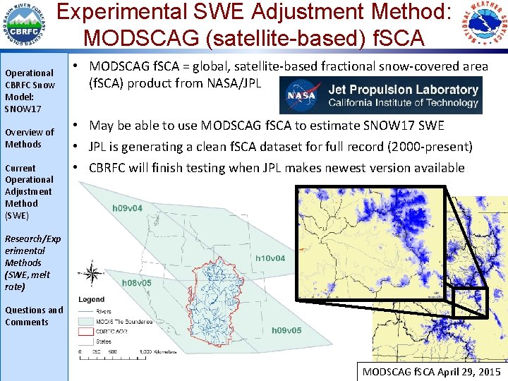
Experimental SWE Adjustment Method: MODSCAG (satellite-based) f. SCA Operational CBRFC Snow Model: SNOW 17 Overview of Methods Current Operational Adjustment Method (SWE) • MODSCAG f. SCA = global, satellite-based fractional snow-covered area (f. SCA) product from NASA/JPL • May be able to use MODSCAG f. SCA to estimate SNOW 17 SWE • JPL is generating a clean f. SCA dataset for full record (2000 -present) • CBRFC will finish testing when JPL makes newest version available Research/Exp erimental Methods (SWE, melt rate) Questions and Comments MODSCAG f. SCA April 29, 2015
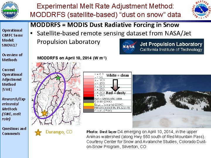
Operational CBRFC Snow Model: SNOW 17 Overview of Methods Experimental Melt Rate Adjustment Method: MODDRFS (satellite-based) “dust on snow” data MODDRFS = MODIS Dust Radiative Forcing in Snow • Satellite-based remote sensing dataset from NASA/Jet Propulsion Laboratory MODDRFS on April 10, 2014 (W m-2) Current Operational Adjustment Method (SWE) White = clean Red = dusty Research/Exp erimental Methods (SWE, melt rate) Questions and Comments Durango, CO Photo: Dust layer D 4 emerging on April 10, 2014, in the upper Animas watershed (along Hwy 550 south of Red Mountain Pass). Courtesy Center for Snow and Avalanche Studies, Colorado Dust 8 on-Snow Program, Silverton, CO
Experimental Melt Rate Adjustment Method: MODDRFS (satellite-based) “dust on snow” data Operational CBRFC Snow Model: SNOW 17 Overview of Methods Current Operational Adjustment Method (SWE) Research/Exp erimental Methods (SWE, melt rate) MODDRFS-informed manual (pre-WY 16) adjustments to snowmelt rate by CBRFC forecasters are helpful but timeconsuming and subjective. Ø Need a more efficient, objective method of incorporating MODDRFS “dust-on-snow” data into CBRFC modeling and forecasting for WY 16 and beyond Ø MODDRFS “dust on snow” data • use it to tweak input temperatures for snow model (SNOW 17, which is a temperature-index snow model) Questions and Comments 9
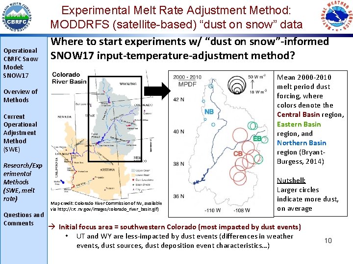
Operational CBRFC Snow Model: SNOW 17 Experimental Melt Rate Adjustment Method: MODDRFS (satellite-based) “dust on snow” data Where to start experiments w/ “dust on snow”-informed SNOW 17 input-temperature-adjustment method? Mean 2000 -2010 melt period dust forcing, where colors denote the Central Basin region, Eastern Basin region, and Northern Basin region (Bryant. Burgess, 2014) Overview of Methods Current Operational Adjustment Method (SWE) Research/Exp erimental Methods (SWE, melt rate) Questions and Comments Map credit: Colorado River Commission of NV, available via http: //crc. nv. gov/images/colorado_river_basin. gif) Nutshell: Larger circles indicate more dust, on average Initial focus area = southwestern Colorado (most impacted by dust events) • UT and WY are less-impacted by dust events (differences in weather events, dust sources, dust deposition event characteristics…) 10
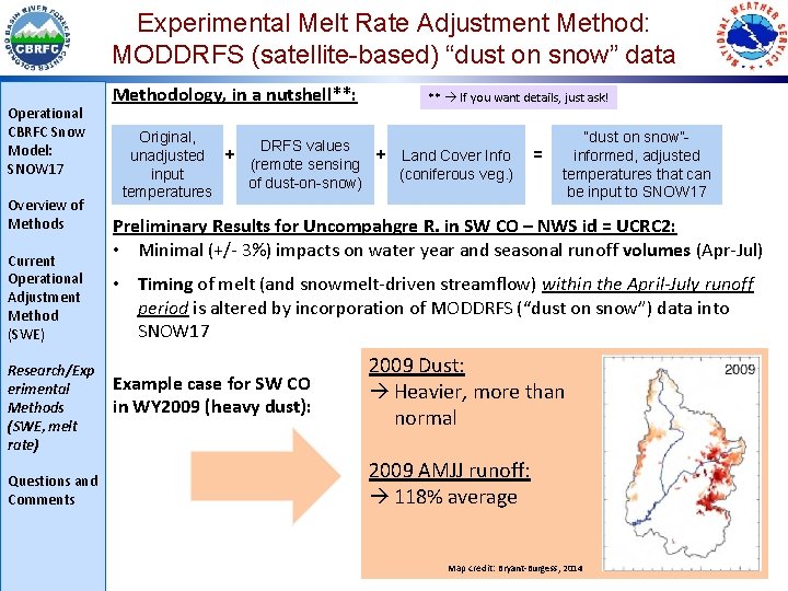
Experimental Melt Rate Adjustment Method: MODDRFS (satellite-based) “dust on snow” data Operational CBRFC Snow Model: SNOW 17 Overview of Methods Current Operational Adjustment Method (SWE) Research/Exp erimental Methods (SWE, melt rate) Questions and Comments Methodology, in a nutshell**: Original, + unadjusted input temperatures + DRFS values (remote sensing of dust-on-snow) ** If you want details, just ask! + Land Cover Info (coniferous veg. ) = “dust on snow”informed, adjusted temperatures that can be input to SNOW 17 Preliminary Results for Uncompahgre R. in SW CO – NWS id = UCRC 2: • Minimal (+/- 3%) impacts on water year and seasonal runoff volumes (Apr-Jul) • Timing of melt (and snowmelt-driven streamflow) within the April-July runoff period is altered by incorporation of MODDRFS (“dust on snow”) data into SNOW 17 Example case for SW CO in WY 2009 (heavy dust): 2009 Dust: Heavier, more than normal 2009 AMJJ runoff: 118% average 11 Map credit: Bryant-Burgess, 2014
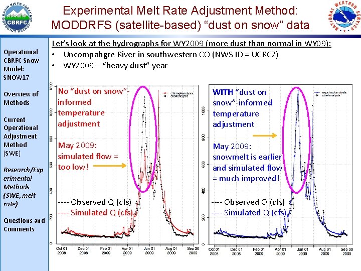
Experimental Melt Rate Adjustment Method: MODDRFS (satellite-based) “dust on snow” data Operational CBRFC Snow Model: SNOW 17 Overview of Methods Current Operational Adjustment Method (SWE) Research/Exp erimental Methods (SWE, melt rate) Questions and Comments Let’s look at the hydrographs for WY 2009 (more dust than normal in WY 09): • Uncompahgre River in southwestern CO (NWS ID = UCRC 2) • WY 2009 – “heavy dust” year No “dust on snow”informed temperature adjustment WITH “dust on snow”-informed temperature adjustment May 2009: simulated flow = too low! May 2009: snowmelt is earlier and simulated flow = much improved! ---- Observed Q (cfs) ---- Simulated Q (cfs) 12
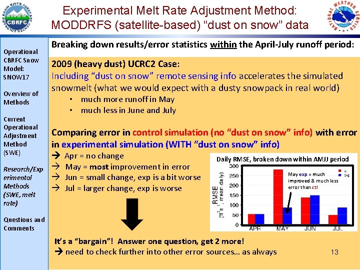
Experimental Melt Rate Adjustment Method: MODDRFS (satellite-based) “dust on snow” data Operational CBRFC Snow Model: SNOW 17 Overview of Methods Current Operational Adjustment Method (SWE) Research/Exp erimental Methods (SWE, melt rate) Breaking down results/error statistics within the April-July runoff period: 2009 (heavy dust) UCRC 2 Case: Including “dust on snow” remote sensing info accelerates the simulated snowmelt (what we would expect with a dusty snowpack in real world) • much more runoff in May • much less in June and July Comparing error in control simulation (no “dust on snow” info) with error in experimental simulation (WITH “dust on snow” info) Apr = no change May = most improvement in error Jun = small change, exp is a bit worse Jul = larger change, exp is worse Daily RMSE, broken down within AMJJ period May exp = much improved & much less error than ctl Questions and Comments It’s a “bargain”! Answer one question, get 2 more! need to check further into other error sources… as always 13
Questions, Comments, and Acknowledgements Operational CBRFC Snow Model: SNOW 17 Overview of Methods Current Operational Adjustment Method (SWE) Research/Exp erimental Methods (SWE, melt rate) Questions and Comments CBRFC: www. cbrfc. noaa. gov Stacie Bender – stacie. bender@noaa. gov Paul Miller - paul. miller@noaa. gov Brent Bernard, John Lhotak, Craig Peterson, Michelle Stokes NASA/JPL: snow. jpl. nasa. gov Thomas Painter - Thomas. Painter@jpl. nasa. gov Catalina Oaida – Catalina. Oaida@jpl. nasa. gov Kostas Andreadis – Konstantinos. M. Andreadis@jpl. nasa. gov Kat Bormann, Paul Ramirez, Ross Laidlaw, Michael Joyce, Chris Mattmann, Ann Bryant Burgess (formerly NASA/JPL and Univ of Utah, now ESIP) NRCS Snow Surveys: www. wcc. nrcs. usda. gov/snow CSAS/CODOS: snowstudies. org, codos. org Chris Landry - clandry@snowstudies. org Jeff Derry – incoming director 14
- Slides: 14