SLEUTH Recent developments and applications Keith C Clarke


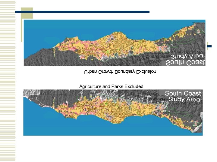
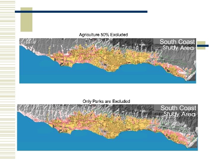
 w Exclusion")
 w State probabilities w Class magnitudes w")
")


 w Placeholder of where and")


 land use maps yet for calibration")

 § Integration")

 w Model metadata w")


")
- Slides: 25
SLEUTH: Recent developments and applications Keith C. Clarke UC Santa Barbara
Background q Urban Dynamics q q q Regional geographic analysis of temporal spatial data bases About a dozen applications of three model versions Retrospective and Analysis q Cellular Automaton Model of Change § § Initial set of state conditions (binary to Anderson II) Change rules Independent agents Urban model drives deltatron model
SLEUTH w Renamed for input data w Slope w Land Use (2) w Exclusion layer w Urbanization (n >=4) w Transportation (n>1) w Hillshade
Land use change properties w Driver (=urbanization) w State probabilities w Class magnitudes w Spatial autocorrelation(s)
Patterns/process of land cover change w Introduction of new land cover type (invasion, diffusion) w Land cover class extension from edges (spread, contagion) w Perpetuation of change (lagged autocorrelation)
Deltatron Dynamics: Land cover w w Delta-space To/From Transition matrix Table of land cover class average slopes Urbanization drives change within the model Urban (and others) invariant class
Deltatrons at work
A Deltatron is: w “Bringer of change” (semi-independent agent) w Placeholder of where and what type of land cover transition took place during its lifetime w Tracks how much time has passed since a change has occurred (Lifetime) w Enforces spatial and temporal auto-correlation of land cover transitions by its life cycle
Deltatron Land Cover Model Phase 1: Create change select random pixel For n new urban cells Select two land classes at random Create delta space Of the two: Find the land class most similar to current slope Average slope Transition Probability Matrix spread change land cover Check the transition probability
Deltatron Land Cover Model Phase 2: Perpetuate change delta space Transition Probability Matrix search for change in the neighborhood find associated land cover transitions create deltatrons n Age or kill deltatrons impose change in land cover n
BUT We don’t have adequate (registered, consistently classified) land use maps yet for calibration of the Deltatron model YET, so…
Land Use/Cover Mapping Anderson Level III for September 1998 Anderson II for 7 other time periods (to 1929)
Work in Progress I NSF: Urban Change – Integrated Modeling Environment (UCIME) § Integration with See. The. Future and other models § Annual transition normalization § Transition trend modeling: Build into model? § Physical models coupled in (MMS, fire/hydrology) § Inclusion of urban density/population (geometry, roads, age)
Work in Progress II w Formalization of SLEUTH Deltatron work n Paper at Banff GIS/EM 4 n Collaboration with LANL n Calibration for SB w Simple (portable) GIS version of SLEUTH n Presented at Banff GIS/EM 4 n Used PCRaster
Work in Progress III w ADEPT (Alexandria Digital Earth Prototype) w Model metadata w Draft standard on web w SLEUTH used as first entry w Concept is to search for data and models simultaneously in an information rich virtual landscape (Iscape) with local extent
UCSB/USGS Collaboration w Software Version 3. 0 n n n MPI: Parallel and Supercomputer results by EPA (Embarassingly Parallel): Paper from Cathey and Matheney Vastly simpler code structure Better memory management Faster Documentation on Gigalopolis Web site w Temporal sensitivity testing n n Can we calibrate short term and predict long term? Can we calibrate with sparse data?
UGROW to See. The. Future Power. Sim Stella
Stella version of See. The. Future
Stella Interface: Web Addition
Santa Barbara Economic Community Project w w w Completed work on indicators and land use goals Build 8 time period GIS, new land use Completed SLEUTH simulations Ported See. The. Future Currently working on: n n n Scenario development for Board/Supervisors Web version on model Linked simulations Report card concept Places-Rated QOL
New applications w Elisabete de Silva Lisbon, Porto. CEUS paper on calibration in rewrite w Frank Tack, Univ. Amsterdam, Netherlands w Michel Le Page. Tijuana, Mexico
Gigalopolis
UCIME (Urban Change Integrated Modeling Environment)