
Simultaneous Nadir Overpass Method for Intersatellite Calibration of
Simultaneous Nadir Overpass Method for Inter-satellite Calibration of Radiometers Changyong Cao NOAA/NESDIS/Center for Satellite Applications & Research (STAR) Presented at the ASIC^3 Workshop, May 16 -18, 2006 1
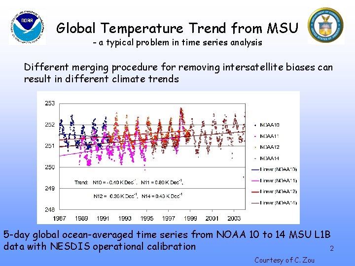
Global Temperature Trend from MSU - a typical problem in time series analysis Different merging procedure for removing intersatellite biases can result in different climate trends 5 -day global ocean-averaged time series from NOAA 10 to 14 MSU L 1 B data with NESDIS operational calibration 2 Courtesy of C. Zou
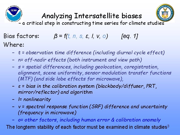
Analyzing Intersatellite biases – a critical step in constructing time series for climate studies Bias factors: Where: β = f(t, n, s, ε, l, v, o) [eq. 1] – t = observation time difference (including diurnal cycle effect) – n= off-nadir effects (both instrument and view path) – s = spatial differences, including geolocation, coregistration, alignment, scene uniformity, sensor modulation transfer functions (MTF) (and side lobe effects for microwave), – ε = bias in the calibration system (blackbody/diffuser, PRT, mirror/reflector) and algorithm – l= nonlinearity – v = spectral response function (SRF) difference and uncertainty (frequency in microwave) – o= other factors, including human error & calibration anomaly The longterm stability of each factor must be examined in climate studies 3
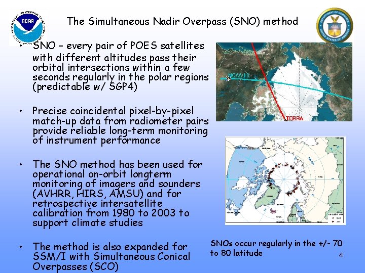
The Simultaneous Nadir Overpass (SNO) method • SNO – every pair of POES satellites with different altitudes pass their orbital intersections within a few seconds regularly in the polar regions (predictable w/ SGP 4) • Precise coincidental pixel-by-pixel match-up data from radiometer pairs provide reliable long-term monitoring of instrument performance • The SNO method has been used for operational on-orbit longterm monitoring of imagers and sounders (AVHRR, HIRS, AMSU) and for retrospective intersatellite calibration from 1980 to 2003 to support climate studies • The method is also expanded for SSM/I with Simultaneous Conical Overpasses (SCO) SNOs occur regularly in the +/- 70 to 80 latitude 4
The SNO/SCO Procedure • Predict SNOs between each pairs of satellites using the orbital perturbation model SGP 4 and appropriate two-line-elements (TLEs) (Cao, et al. , 2004) • Download Level 1 B data that contain SNO observations Criteria: 1). At the SNO, the distance between the nadir pixels from the two satellites should be less than 1 pixel. 2). time difference between the nadir pixels from the two satellites should be less than 30 seconds. • SNO data between satellites are matched pixel-by-pixel based on their latitude/longitude. • Optimize match through radiance correlation to reduce the effect of navigation errors • Statistics of the biases in radiance and brightness temperature/reflectance between two satellites are calculated for pixels within a small nadir window. • The SNO time series of the biases and RMS are plotted. 5
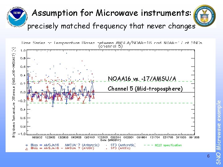
Assumption for Microwave instruments: precisely matched frequency that never changes NOAA 16 vs. -17/AMSU/A 6 SNO Microwave example Channel 5 (Mid-troposphere)
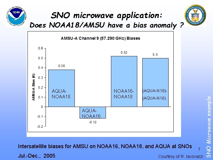
SNO microwave application: Does NOAA 18/AMSU have a bias anomaly ? NOAA 16 NOAA 18 (AQUA-N 18)(AQUA-N 16) AQUANOAA 16 Intersatellite biases for AMSU on NOAA 16, NOAA 18, and AQUA at SNOs Jul. -Dec. , 2005 7 Courtesy of R. Iacovazzi SNO Microwave example AQUANOAA 18
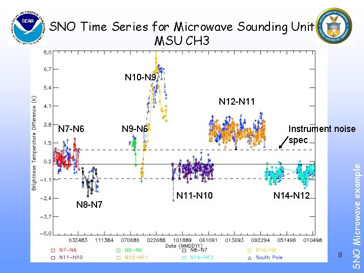
SNO Time Series for Microwave Sounding Unit MSU CH 3 N 10 -N 9 N 12 -N 11 N 8 -N 7 N 9 -N 6 Instrument noise spec N 11 -N 10 N 14 -N 12 8 SNO Microwave example N 7 -N 6
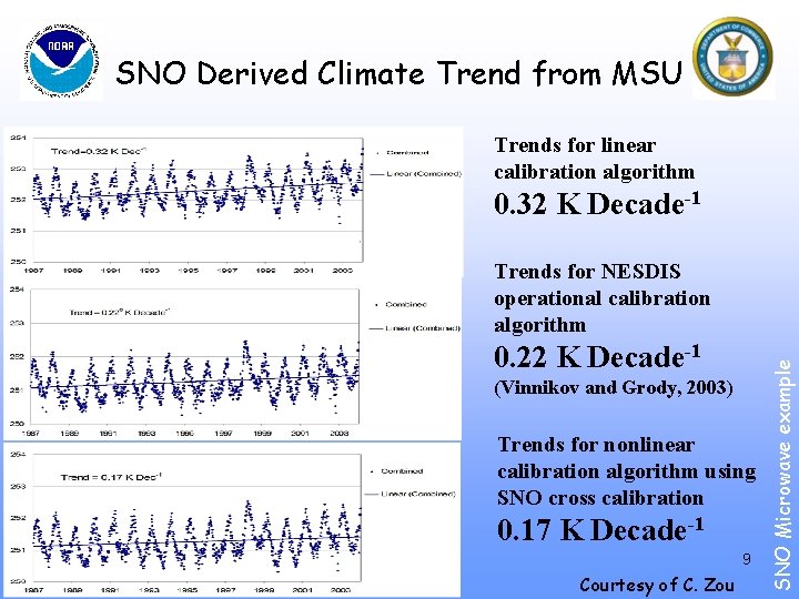
SNO Derived Climate Trend from MSU Trends for linear calibration algorithm 0. 32 K Decade-1 0. 22 K Decade-1 (Vinnikov and Grody, 2003) Trends for nonlinear calibration algorithm using SNO cross calibration 0. 17 K Decade-1 9 Courtesy of C. Zou SNO Microwave example Trends for NESDIS operational calibration algorithm
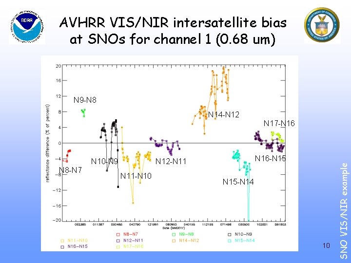
AVHRR VIS/NIR intersatellite bias at SNOs for channel 1 (0. 68 um) N 9 -N 8 N 14 -N 12 N 10 -N 9 N 8 -N 7 N 16 -N 15 N 12 -N 11 -N 10 N 15 -N 14 10 SNO VIS/NIR example N 17 -N 16
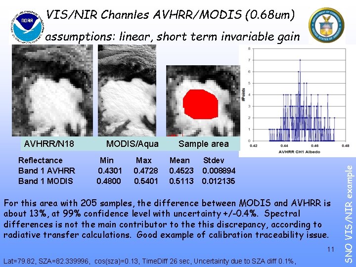
VIS/NIR Channles AVHRR/MODIS (0. 68 um) assumptions: linear, short term invariable gain Reflectance Band 1 AVHRR Band 1 MODIS Min 0. 4301 0. 4800 Max 0. 4728 0. 5401 Mean 0. 4523 0. 5113 Stdev 0. 008894 0. 012135 For this area with 205 samples, the difference between MODIS and AVHRR is about 13%, at 99% confidence level with uncertainty +/-0. 4%. Spectral differences is not the main contributor to the this discrepancy, according to radiative transfer calculations. Good example of calibration traceability issue. 11 Lat=79. 82, SZA=82. 339996, cos(sza)=0. 13, Time. Diff 26 sec, Uncertainty due to SZA diff 0. 1%, SNO VIS/NIR example AVHRR/N 18 MODIS/Aqua Sample area
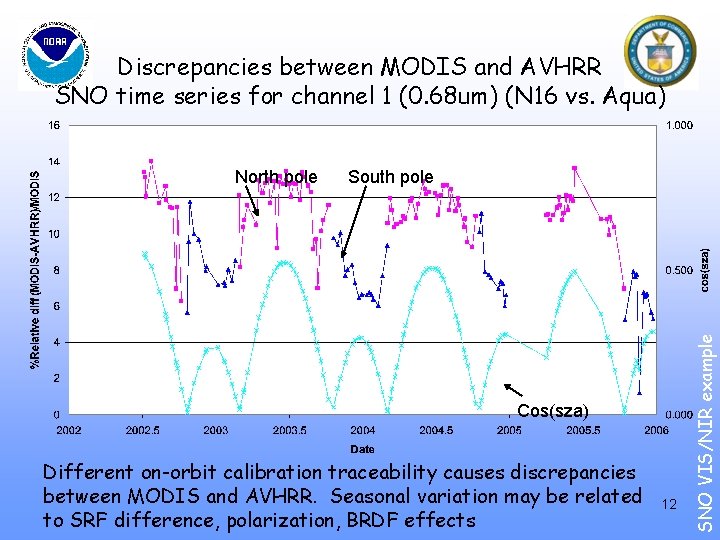
Discrepancies between MODIS and AVHRR SNO time series for channel 1 (0. 68 um) (N 16 vs. Aqua) Cos(sza) Different on-orbit calibration traceability causes discrepancies between MODIS and AVHRR. Seasonal variation may be related to SRF difference, polarization, BRDF effects 12 SNO VIS/NIR example North pole South pole
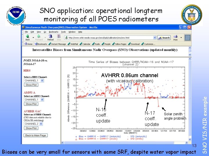
SNO application: operational longterm monitoring of all POES radiometers AVHRR 0. 86 um channel N-16 coeff. update N-17 coeff. update Solar zenith angle problem 13 Biases can be very small for sensors with same SRF, despite water vapor impact SNO VIS/NIR example (with vicarious calibration)
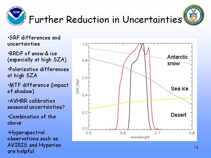
Further Reduction in Uncertainties • SRF differences and uncertainties • BRDF of snow & ice (especially at high SZA) • Polarization differences at high SZA • MTF difference (impact of shadow) Antarctic snow Sea ice • AVHRR calibration seasonal uncertainties? • Combination of the above • Hyperspectral observations such as AVIRIS and Hyperion are helpful Desert 14
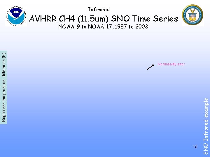
Infrared AVHRR CH 4 (11. 5 um) SNO Time Series Nonlinearity error 15 SNO Infrared example Brightness temperature difference (K) NOAA-9 to NOAA-17, 1987 to 2003
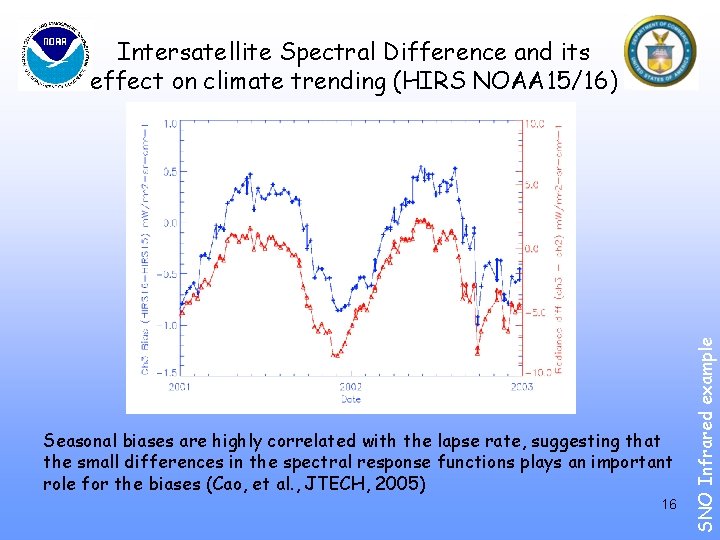
Seasonal biases are highly correlated with the lapse rate, suggesting that the small differences in the spectral response functions plays an important role for the biases (Cao, et al. , JTECH, 2005) 16 SNO Infrared example Intersatellite Spectral Difference and its effect on climate trending (HIRS NOAA 15/16)
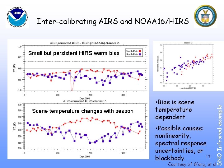
Inter-calibrating AIRS and NOAA 16/HIRS Scene temperature changes with season • Bias is scene temperature dependent • Possible causes: nonlinearity, spectral response uncertainties, or 17 blackbody. SNO Infrared example Small but persistent HIRS warm bias Courtesy of Wang, et al
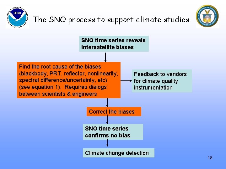
The SNO process to support climate studies SNO time series reveals intersatellite biases Find the root cause of the biases (blackbody, PRT, reflector, nonlinearity, spectral difference/uncertainty, etc) (see equation 1). Requires dialogs between scientists & engineers Feedback to vendors for climate quality instrumentation Correct the biases SNO time series confirms no bias Climate change detection 18
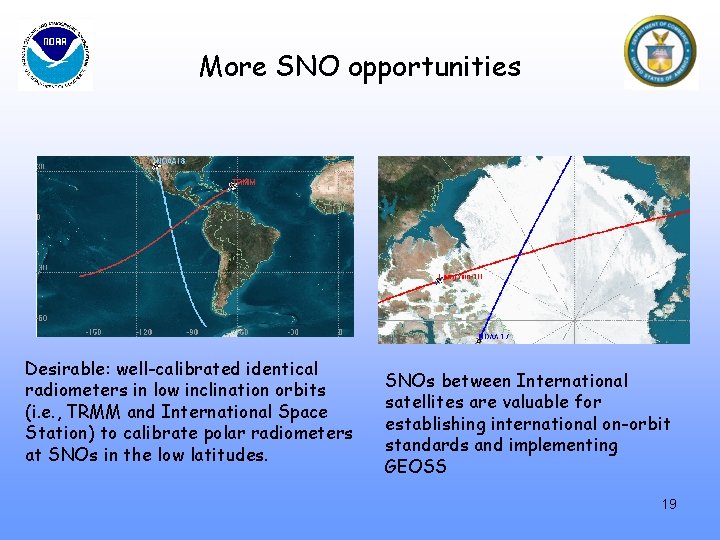
More SNO opportunities Desirable: well-calibrated identical radiometers in low inclination orbits (i. e. , TRMM and International Space Station) to calibrate polar radiometers at SNOs in the low latitudes. SNOs between International satellites are valuable for establishing international on-orbit standards and implementing GEOSS 19
Summary • SNO - an enabling methodology for improving intersatellite calibration. Works well for the microwave, visible/near infrared, and infrared instruments. • A simple, unambiguous, and robust method that produces highly repeatable results. • Very useful for on-orbit verification and longterm monitoring of instrument performance, improving the calibration consistency of historical data to support climate studies, and establishing the calibration links between operational satellite radiometers. • The SNOs will bring together all the satellite radiometers and become an important tool for the implementation of GEOSS. 20
Acknowledgements • This study is partially funded by: – The Integrated Program Office (IPO) under the Internal Government Studies (IGS) Program – The Environmental Services Data and Information Management (ESDIM) of NOAA’s Geo. Spatial Data and Climate Services (GDCS) group, and – The Product Systems Development and Implementation (PSDI) program of NOAA/NESDIS/OSD. • Thanks are extended to M. Goldberg, F. Weng, J. Sullivan, R. Iacovazzi, L. Wang, P. Ciren, F. Yu, and X. Hui for their contributions and support. • The contents presented here are solely the opinions of the authors and do not constitute a statement of policy, decision, or position on behalf of NOAA or the U. S. Government. 21
References SNO methodology: Cao, C. , P. Ciren, M. Goldberg, F. Weng, and C. Zou, 2005, Simultaneous Nadir Overpasses for NOAA-6 to NOAA-17 satellites from 1980 to 2003 for the intersatellite calibration of radiometers, NOAA Technical Report Cao, C. , M. Weinreb, and H. Xu, 2004, Predicting simultaneous nadir overpasses among polar-orbiting meteorological satellites for the intersatellite calibration of radiometers. Journal of Atmospheric and Oceanic Technology, Vol. 21, April 2004, pp. 537 -542. Applications to Infrared sounders: Cao, C. , H. Xu, J. Sullivan, L. Mc. Millin, P. Ciren, and Y. Hou, 2005, Intersatellite radiance biases for the High Resolution Infrared Radiation Sounders (HIRS) onboard NOAA-15, -16, and -17 from simultaneous nadir observations. Journal of Atmospheric and Oceanic Technology, Vol. 22, No. 4, pp. 381 -395. Cao, C, and P. Ciren, 2004, Inflight spectral calibration of HIRS using AIRS observations, 13 th conference on Satellite Meteorology and Oceanography, Sept. 20 -23, 2004, Norfolk, VA. Ciren, P. and C. Cao, 2003, First comparison of radiances measured by AIRS/AQUA and HIRS/NOAA-16&-17, Proceedings of the International ATOVS Working Group Conference, ITSC XIII, Sainte Adele, Canada, Oct. 29, - Nov. 4, 2003. Applications to Microwave sounders and climate trending: Zou, C. , M. Goldberg, Z. Cheng, N. Grody, J. Sullivan, C. Cao, and D. Tarpley, 2004, MSU channel 2 brightness temperature trend when calibrated using the simultaneous nadir overpass method, submitted to JGR. Applications to Imaging radiometers: Cao, C. , and A. Heidinger, 2002, Inter-Comparison of the Longwave Infrared Channels of MODIS and AVHRR/NOAA-16 using Simultaneous Nadir Observations at Orbit Intersections, Earth Observing Systems, VII, Edited by W. Barnes, Proceedings of SPIE Vol. 4814, pp. 306 -316. Seattle, WA. Heidinger, A, C. Cao, and J. Sullivan, 2002, Using MODIS to calibrate AVHRR reflectance channels, Journal of Geophysical Research, Vol. 107, No. D 23, 4702. 22 Wu, A. , X. Xiong, C. Cao, X. Wu, W. Barnes, 2004, Inter-comparison of radiometric calibration of Terra and Aqua MODIS 11 um and 12 um bands, Proceedings of SPIE, 2004, Denver, CO.
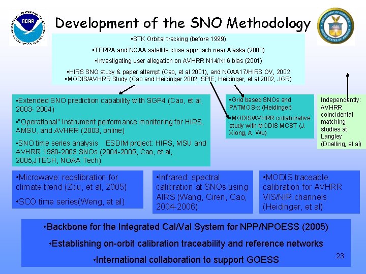
Development of the SNO Methodology • STK Orbital tracking (before 1999) • TERRA and NOAA satellite close approach near Alaska (2000) • Investigating user allegation on AVHRR N 14/N 16 bias (2001) • HIRS SNO study & paper attempt (Cao, et al 2001), and NOAA 17/HIRS OV, 2002 • MODIS/AVHRR Study (Cao and Heidinger 2002, SPIE; Heidinger, et al 2002, JGR) • Extended SNO prediction capability with SGP 4 (Cao, et al, 2003 - 2004) • Grid based SNOs and PATMOS-x (Heidinger) • “Operational” Instrument performance monitoring for HIRS, AMSU, and AVHRR (2003, online) • MODIS/AVHRR collaborative study with MODIS MCST (J. Xiong, A. Wu) • SNO time series analysis ESDIM project: HIRS, MSU and AVHRR 1980 -2003 SNOs (2004 -2005, Cao, et al, 2005, JTECH, NOAA Tech) • Microwave: recalibration for climate trend (Zou, et al, 2005) • SCO time series(Weng, et al) • Infrared: spectral calibration at SNOs using AIRS (Wang, Ciren, Cao, 2004 -2006) Independently: AVHRR coincidental matching studies at Langley (Doelling, et al) • MODIS traceable calibration for AVHRR VIS/NIR channels (Heidinger, et al) • Backbone for the Integrated Cal/Val System for NPP/NPOESS (2005) • Establishing on-orbit calibration traceability and reference networks • International collaboration to support GOESS 23
- Slides: 23