Severe Weather Conditions that form Thunderstorms Tornadoes Hurricanes


 This results")


 adding more energy to the storm More")


 and Katrina (As")


 –")
- Slides: 53
Severe Weather Conditions that form: Thunderstorms Tornadoes Hurricanes
• http: //www. classzone. com/books/earth_sci ence/terc/content/visualizations/es 2002 page 01. cfm? chapter_no=visualizatio n
A. Thunderstorms 1. Created when: a. cold dense air, moving from the north along the surface of the earth, burrows under a warm moist air mass that is traveling north. b. The warm air rises quickly producing cumulonimbus clouds
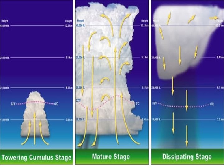
Thunderstorm Stages Stage 1: Cumulus stage Updraft carries water vapor to up in troposphere where condensation begins to form cumulus cloud. The cumulus clouds expands both vertically and laterally. .
Stage 2: Mature stage The first drop of precipitation reaches the ground. Water droplets become too heavy for the updraft. Cloud tops exceed 60, 000 feet upwards. Strong winds cause the cloud tops to create an anvil shape. At the top of the cloud ice crystals form. Near the end of this stage, the rain may be the heaviest, more lightning can be created, and hail, strong winds and tornadoes may form.
• Near the end of this stage, the rain may be the heaviest, • more lightning can be created, • hail may be created • strong winds and tornadoes may form
Stage 3: Dissipating Stage The end of a thunderstorm. Precipitation falls through the cloud, breaks the cloud up. During the dissipating stage, the humidity in the air drops and the precipitation ends.
Super cell thunderstorms The stronger thunderstorms are called super cells Super cells are large, powerful thunderstorms. These have strong vertical wind with changes in wind speed and direction. Tornadoes can occur from these.
Human Impact Lightning – power outages, personal injury, deaths, fires, damage to environment, property damage, Floods- property damage, landslides, deaths, emotional trauma, impedes transportation, Strong Winds – property damage, power outages, possible deaths, Hail – property damage, personal injury, Rain/Snow – can create floods
B. Tornadoes Created when: • during a thunderstorm when the warm air spirals upward (updraft) • latent heat is released (as water vapor condenses). • The rotating updraft gains velocity.
Tornados happen: a. occur in the spring and summer b. most frequent from March to June c. common in the parts of Great Plains, Texas and Oklahoma = Tornado Alley
Conditions for Tornado formation a. Tornados form when strong cold, dry air mass is overtaking a very warm, moist air mass b. Thunderstorms develop with strong updrafts c. The strong updrafts that are created become a tornado.
Tornado Producing Storm along a Cold Front In the picture: The satellite showed a storm system ("L") in southeast Colorado, and severe storms along a cold front from Kansas to Texas. Picture and commentary from NOAA, gov
Dryline • Where the dry and the moist air meet is the dryline. • Updraft occurs at this point forming storms and possibly tornados
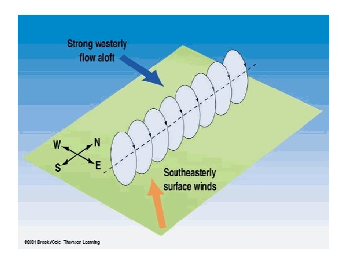
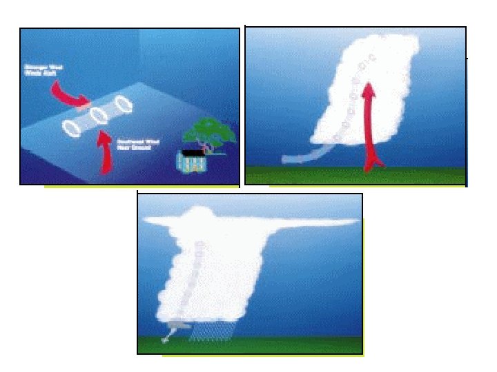
As the tornado forms: a. the storm approaches, there is a change in wind direction and an increase in wind speed b. This creates an invisible, horizontal spinning effect in the lower atmosphere.
c. Rising air within the thunderstorm updraft tilts the rotating air from horizontal to vertical. d. An area of rotation, 2 -6 miles wide, now extends through much of the storm. Most strong and violent tornadoes form within this area of strong rotation
e. Moments later a strong tornado can develop in this area.
Supercell Tornado Formation Tornadoes are characterized by a rotating updraft (usually cyclonic) This results from a storm growing in an environment of significant vertical wind shear. Wind shear occurs when the winds are changing direction and increasing with height.
Fujita Tornado Damage Scale Developed in 1971 by T. Theodore Fujita • F 0 Wind speed < 73 mph Light damage. Some damage to chimneys; branches broken off trees; shallow-rooted trees pushed over; sign boards damaged. • F 1 Wind speed 73 -112 mph Moderate damage. Peels surface off roofs; mobile homes pushed off foundations or overturned; moving autos blown off roads.
• F 2 Wind speed 113 -157 mph Considerable damage. Roofs torn off frame houses; mobile homes demolished; boxcars overturned; large trees snapped or uprooted; light-object missiles generated; cars lifted off ground. • F 3 Wind speed 158 -206 mph Severe damage. Roofs and some walls torn off well-constructed houses; trains overturned; most trees in forest uprooted; heavy cars lifted off the ground and thrown.
F 4 Wind speed 207 -260 mph Devastating damage. Well-constructed houses leveled; structures with weak foundations blown away some distance; cars thrown and large missiles generated F 5 Wind speed 261 -318 mph Incredible damage. Strong frame houses leveled off foundations and swept away; automobile-sized missiles fly through the air in excess of 100 meters (109 yds); trees debarked; incredible phenomena will occur.
Why Tornadoes in the Spring and Summer? • Because the northern hemisphere is tilted toward the sun, there is a greater fluctuation between air mass temperatures in the spring and the summer.
C. Hurricanes 1. Hurricane Overview a. Definition: A hurricane is a large tropical cyclone capable of high wind, heavy rains and intense flooding b. May include thunderstorms, tornados, winds up to and beyond 155 MPH and storm surges of 15 feet or more c. Storms turn counter-clockwise in the northern hemisphere and clockwise in the southern hemisphere
Rotation of a Hurricane Cyclone Heta over The South Pacific-Southern Hemisphere – Jan 2004 • • Notice the clockwise rotation • Hurricane Ivan over the Gulf Coast – Sept 2004 • Notice the counterclockwise rotation.
2. Created when: a. There is a pre-existing low pressure disturbance b. The ocean temp is at least 80 o F. c. There are light upper level wind-low wind shear
Why Do Hurricanes Form in Summer? Ocean Temperatures March 2003 Ocean Temperatures July 2003
Hurricanes
How Hurricanes form: a. The low pressure disturbance comes in contact with the warm ocean water b. As the warm, moist air rises, the pressure decreases c. As the air rises, it cools slightly, condensing the water vapor.
d. This condensation releases heat (latent heat) adding more energy to the storm More on Energy of a Hurricane
e. The cloud tops will grow higher and the storm will strengthen f. As it gets stronger, the storm will start to circulate around the low
4. Growth and death of a hurricane a. If the storms stays over warm water and upper level winds stay light, the storm will usually strengthen b. If the storms passes over cooler water, the storm will start to dissipate c. Landfall will quickly weaken a storm because it shuts off it’s energy supply (heat) d. The storm will re-intensify if it moves over warmer waters again
Hurricane Ivan’s Path
5. Dangers of a hurricane a. Storm Surge 1. Storm surge is a large dome of water 50 100 miles wide 2. Can be more than 15 feet deep 3. “Pulled up” by the decrease of air pressure around the eye and “pushed up” by the high winds 4. Greatest loss of life associated with storm surges (flooding)
More Storm Surge
b. High Winds 1. The highest winds are generally on the northeast (while making landfall on south facing shores) or the north (while making landfall on east facing shores). 2. They can rip apart roofs and destroy unsecured buildings 3. Damage from flying debris as well
c. Rainfall 1. A typical hurricane can bring 6 to 12 inches of rain 2. This causes flash flooding and increasing the flooding brought by storm surges d. Tornados 1. Tornados can form on the fringes of the storm 2. The greater the storm, the more tornados are possible
Saffir - Simpson Scale 6. Saffir – Simpson Scale a. Tropical Depression Surface wind speeds below 39 mph; Must have formed over tropical waters; Damage minimal; Not named
Saffir - Simpson Scale b. Tropical Storm Surface wind speeds 40 mph – 73 mp: Have some circulation; Damage to foliage and unattached objects; Named
Saffir – Simpson Scale c. Category 1 Surface wind speeds 74 mph – 95 mph; No real damage to building structures Damages mobile homes, foliage and, some coastal flooding Hurricane Ophelia (2005)
Saffir – Simpson Scale d. Category 2 Surface wind speeds 96 mph – 110 mph; Roofing material and windows damaged; Piers damaged and small watercraft can break moorings Hurricane Erin - 1995
Saffir – Simpson Scale Aftermath of Hurricane Katrina: Christian Pass MS, 2005 e. Category 3 Surface wind speeds 111 mph – 130 mph; Major flooding along coastal regions, damage from floating debris Small buildings severely damaged
Saffir – Simpson Scale f. Category 4 Surface wind speeds 131 mph – 155 mph; Roofs pulled off structures; Major beach erosion; Major flooding damage of lower floors of structures
Saffir – Simpson Scale: Cat. 4 Upper Left: Toppled House from NC Lower Left: Damage from Dean, Jamaica 2007 Above: Hurricane Hugo 1989
Saffir – Simpson Scale g. Category 5 Surface wind speeds greater than 155 mph. ; Major damage to all buildings; Small buildings completely gone; Most building near shore completely damaged or gone; Very few have made U. S. landfall as a category 5
Saffir – Simpson Scale Cat. 5 Comparing Hurricanes Ophelia (Cat. 1) and Katrina (As a Cat. 5) 2005 Eye of Hurricane Katrina 2005 Damage from Hurricane Andrew, FL, 1992
Societal Impact of Hurricanes 7. Societal Impact of Hurricanes a. Loss of Life b. Property Damage
The Year That Was: 2005 • This was the first season on record with 26 named storms in a single hurricane season. It was also the first season that 7 tropical storms formed before August 1 st. • A new record was set when 13 hurricanes formed in the Atlantic Basin in 2005. • Out of the 13 hurricanes that formed, 7 became major hurricanes (category 3 or higher) and a new record was set when three of those hurricanes (Katrina, Rita, & Wilma) reached category 5 status in one season.
The Year That Was: 2005 • For the first time since records began, four major hurricanes hit the U. S. (Dennis, Katrina, Rita, Wilma). • Five hurricanes (Dennis, Katrina, Ophelia, Rita and Wilma) and three tropical storms (Arlene, Cindy and Tammy) directly impacted the U. S. • When this year’s list of hurricane names expired, letters of the Greek alphabet were used to name storms for the first time.
The Year That Was: 2005 • Hurricane Katrina is now the costliest hurricane on record with at least $80 billion in damages. The previous record was Hurricane Andrew (1992) with $26 billion in damages (1992 dollars) or $36 billion (2005 dollars). • Hurricane Katrina was also the deadliest hurricane on record since 1928 with at least 1, 300 casualties. • Hurricane Wilma became the strongest hurricane ever recorded in the Atlantic Basin when the storm’s central pressure plummeted to 882 mb. The previous record was in 1988 when Hurricane Gilberts central pressure dropped to 888 mb.
Rotation of a Hurricane • Cyclone Heta over The South Pacific (Sothern Hemisphere) – Jan 2004 • Notice the clockwise rotation • Hurricane Ivan over the Gulf Coast – Sept 2004 • Notice the counterclockwise rotation. More on Energy of a Hurricane