Session 17 Passage Planning 1 Electronic Homework Passage


 / 4. 5 m")
 / 4. 5 m Tide")
 3. 5 M Tide AXE YACHT CLUB")
 4. 5 M 1. 0")
 2. 5 M 1. 0")

 function shows your")
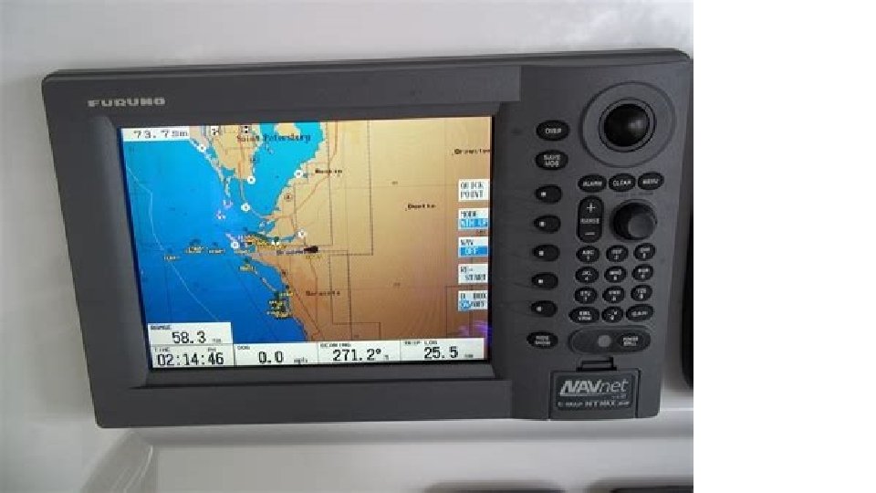
 WP 1 XTE 1100 05. 4 AXE YACHT CLUB")


- Slides: 36
Session 17 Passage Planning 1 Electronic
Homework • Passage Making Page 21 Q 1 -7
Symbols please consult Page 91 of Course Notes: Fix Water Track Tide Rhumb line or Course Over the Ground Dead Reckoning (DR) AXE YACHT CLUB Estimated position (EP)
GPS – good practice GPS . . . pilotage Retrospective plotting a more of your appropriate GPS Plan aheadis often position of method means navigation you will when always in close be playing catch up. . . to hazards proximity
GPS – back up GPS . . . depth, Always Hand. . . passing. . . radar bearing back range/bearing allowing charted up compass your for objects GPS height bearings. . . position of tidewith and information distance run from another source
GPS – good practice GPS Keep a record of your position at regular intervals on the chart and in the ship’s log
GPS functions GPS Common terms found on a GPS display present position shown in latitude and longitude course over the ground bearing to WPT from present position range to WPT from present position time to go to WPT speed over the ground cross track error velocity made good
Information from the GPS linked to a plotter • Lat / Long and Elevation • COG and SOG • Distance and bearing to waypoint • ETA at waypoint – although this isn’t always accurate (tides, wind) • Cross-track error AXE YACHT CLUB
GPS – waypoints GPS . . . they are positions Waypoints are tools stored to helpinyou thenavigate. . . memory of a GPS that are used as reference points
GPS routes GPS Plot your waypoints adjacent to rather than directly on charted objects
GPS/Chart plotter routes GPS In busy areas, bear in mind that lots of other boats could be using the same waypoint
GPS routes GPS Always thea series waypoints on a chartinto anda You canplot enter of waypoints check distances GPS tothe make a routeand bearings between them
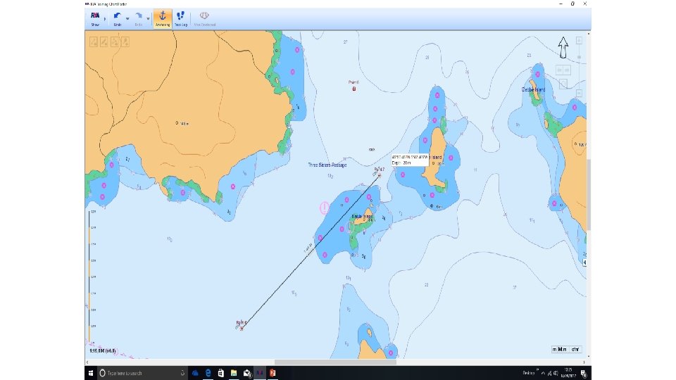
Practical Demo Routes on RYA Plotter • Navionics video • RYA Plotter
Waypoint Navigation 1 • Take waypoints from a large scale chart or the almanac • Position the waypoint on the safe side of buoys etc. • Check track from the start position to the waypoint to ensure that the track does not cross hazards. WP 4 WP 2
Plotting Techniques with GPS • Sailing / displacement power boat techniques: • Latitude and Longitude • Bearing and distance to a Waypoint • Use of centre point of compass rose • Use destination and plot distance and bearing • Planing power boat techniques: • Distance to W. P. and X. T. E. • Web with distance and bearing to waypoint. AXE YACHT CLUB
– other ways of using waypoints Use You acan compass your rose position centre quickly as a waypoint Putting aplot waypoint at the centre ofby a enteringposition enables easily to becharted plottedpositions easily by as compass rose. . . found waypoints range and bearing BRG 065°T RNG 14. 3 M
Bearing and Distance WP 4 295° (M) / 4. 5 m
Bearing and Distance WP 4 295° (M) / 4. 5 m Tide
Bearing and Distance WP 4 295° (T) 3. 5 M Tide AXE YACHT CLUB
Bearing and Distance WP 4 0. 5 295° (T) 4. 5 M 1. 0 1. 5 2. 0 Tide 280 2. 5 305 3. 0 005 335 320
Bearing and Distance WP 4 0. 5 335° (T) 2. 5 M 1. 0 1. 5 2. 0 Tide 280 2. 5 305 3. 0 005 335 320
Bearing and Distance WP 4 0. 5 1. 0 1. 5 2. 0 280 2. 5 305 3. 0 005 335 320
GPS – cross track error GPS The cross track error (XTE) function shows your lateral distance from the rhumb line between two waypoints
Cross Track Error (XTE) WP 1 XTE 1100 05. 4 AXE YACHT CLUB
GPS – other ways of using waypoints A way of easily plotting position is to draw a XTE ladder. . . WP 1 XTE 0. 5 M RNG 6. 0 M
Distance to Waypoint and Cross Track Error WP 1 Grid drawn on chart from starting position to way point. Position is plotted by distance to run and XTE. e. g. Distance = 6. 0 M XTE = 0. 5 M to starboard. 1 0. 5 AXE YACHT CLUB 0. 5 1
Practical Limitations • Check on obstacles and dangers • GPS isn’t intelligent only a waypoint view • Check input on chart and route view • Common sense and situational awareness • Chart preparations • Not dynamic • CTS • Update regularly, especially for tide • Route monitor/ XTE
Possible problems with GPS • Power failure • Aerial failure • Transmissions from mobile phones • Interruption of, or changes to, the satellite system • Greatest risk is the user error plus. . . • • • Datum Magnetic or true bearings Variation Deviation Leeway AXE YACHT CLUB
READING ERRORS • BE CAREFUL/METHODICAL • USE BEARING AND RANGE • CHECK AGAINST SECOND INPUT (EP, DEPTH, ASPECT ETC) • REASONABLENESS • Screen views can change according to output device scale/selected colour scheme
Scale and View/Colour
Automatic Identification System - AIS • Icons can differentiate between sailing, power, fast ferries, commercial vessels, SAR helicopters and Atons. • Predicted areas of danger. An integrated chart plotter can show a vector indicating direction of your vessel and one for a crossing vessel with a hatched red area ahead of the other vessel. Vessel icons can show red if risk of collision – useful but: • You must be aware of and obey the COLREGS, visual checks (or radar) and making your intentions clear by bold and early moves. • Proximity alarms • Free AIS Ship Tracking of Marine Traffic - Vessel. Finder
• See Electronic Navigation Resources Booklet - discuss slides
RADAR range rings
Homework • Safety Q 1 -12 • Route Planning With a Chart Plotter • Page 14 Q 4 Incudes rolling road/XTE • Page 15 Q 1 -9 Route Planning with a chart plotter