Sequent Occupance The term sequent occupance was coined


")


")


 For the most part,")
")


- Slides: 42
Sequent Occupance The term "sequent occupance" was coined in 1929 by American geographer Derwent Whittlesey to describe: “the process by which a landscape is gradually transformed by a succession of occupying populations, each of which modifies the landscape left by the previous groups”
So in other words: The seeds of change are within a place: Determined by: Environment and Culture Associated Ideas: culture is affected by the environment, but the environment does not determine culture (vs. environmental determinism) places change because a culture develops or a new culture dominates the landscape the comparative advantage of a place can be used again and again, regardless of the historical experience of a place Older construction/use can be benefit or a detriment to a site
So do people live in the same places? Suggestions for answering this question? historical evidence maps literature archeology Where should you look for sequent occupance? Site Characteristics Almost anywhere people now live Associated Questions: What are benefits of occupying a place that had been inhabited? What are detriments of occupying a place that had been inhabited? Does the conqueror or conquered shape the culture/site most? Would you find cultural traits for a specific place, regardless of cultural change?
Site Characteristics Comparative Advantage: the idea that a place has certain advantages (relative and/or absolute) over other places. Of the places people live, many tend to on rivers. The best place to find old large cities is just before you reach the delta. Name a city with this site characteristic. Why don’t people live in deltas? Another place is where two rivers meet. Why is this a comparative advantage? Shallow places on rivers allow people to ford (cross) the river. Towns often form there because it is a good place to cross. Ports are places that have deep water so it is easy to get out to sea. Often they are in protected places called harbors.
This flowchart that attempts to determine comparative advantage
Site Characteristics Defensive Difficult to attack e. g. hill-top or island Hill-foot Sheltered, with flat land for building and farming Gap Lower, more sheltered land between two hills Wet point Close to water in a dry area Dry point On higher, dry area close to wet land e. g. marshes or flooding rivers Route centre Focus of routes (e. g. roads) from surrounding area Bridging point Where bridges can be built over a river Locate the sites by characteristic
The importance of individual site features changes through time: In Early Times (before 1800) Feature Good defence Close to water Close to woodland On useful farmland Flat land Good communications Reason / example Hard to attack e. g. hill top, island For water and fish supplies For fuel, building materials and food To provide food Makes building easier By road and river In Later Times (after 1800), other features became important when considering the site of a settlement Feature Close to resources Close to ports Faster communication Pleasant environment Reason / example As raw materials for industry e. g. limestone or coal To transport raw materials or goods As industry grew and developed e. g. canals, railways and more recently, motorways and airports. For a) larger number of retired people and b) hi-tech industries which wish to locate in attractive areas
Culture Hearth a culture hearth is a source area, innovation center, a place of origin of a major culture
The Nile Valley
Map of Ancient Egypt and modern view from space at night Notice how easy it is to see the Nile River by its electric using population. How did/does this river impact its surrounding cultures? What areas seem less inhabited? Why? http: //apod. nasa. gov/apod/image/0011/earthlights 2_dmsp_big. jpg
The Temple of Luxor http: //www. eyelid. co. uk/index. htm This temple completed by Tutankhamun and Horemheb and added to by Ramses II. Towards the rear is a granite shrine dedicated to Alexander the Great. During the Christian Era it was converted to a church. The Romans even built fortifications on the site. Most of the site was buried for thousands of year until the mosque of Sufi Shaykh Yusuf Abu al-Hajjaj was built on top of it. Since the mosque is still being used this site has long been a center of religious worship for more than 3000 years. http: //www. planetware. com/map/luxor-temple-map-egy-lt. htm
This is a market scene from a stela in Luxor. Identify activities that would be in a commercial setting today. http: //www. terraflex. co. il/ad/egypt/trade/market_scene. htm
Vesuvius In 79 CE Vesuvius erupted for approximately 19 hours and dumped a cubic mile of lava and ash over the surrounding area. Herculaneum, which was covered by lava, and Pompeii, blanketed in ash, are the best known cities that were destroyed. It has erupted many times since, however people have continued to live not just in the vicinity, they have built over an ancient city that was covered with lava.
Inside the crater
Naples erculaneum Scars from last major lava flow (1964)
Vesuvius Modern city of Ercolano Top of lava plain Excavated Roman city of Herculaneum
Modern Ercolano edge of lava plain Vesuvius
Wood left from 79 CE. Since the city was covered with lava, oxygen and biological life that helps decay could not break it down. Notice the charring from the intense heat.
Vesuvius overlooking the Roman forum at Pompeii.
A grim reminder of volcanic activity on the human form.
This is a Roman villa that is being reconstructed in Oplanati. Notice the edge of the lava plain on the right side of the picture and the modern city built on the plain.
In earlier times parchment was used as we use paper today. Parchment is made from either the skin of calves, sheep, or goats, and was expensive to make. A palimpsest was basically recycled parchment that someone had scraped off the ink and then wrote on for a second (or even third or fourth) time (see picture on the right). In similar fashion often people reuse or change places on the planet. Just like the old parchment, traces of earlier use can be detected. Geographers use this term to describe the traces of earlier cultural landscape at a location. Palimpsests
Many of the world’s major cities have palimpsests. Rome for example would have the Pantheon (top right), the forum (bottom right) and the Coliseum (above) in the heart of the modern city.
Athens, looking up to the Acropolis and looking down into the city. Some of the palimpsest aren’t ancient like the site of the first modern Olympics, which was cut off so they could build a road.
Amsterdam: a look at infrastructure In 1342 the mounds located on either side of the river Amstel were raised and extended, the initial stage in the growth of medieval Amsterdam after 1425 Amsterdam after 1340
A after 1425 M after 1585 S T E R after 1585 D A M after 1613
Amsterdam after 1613 Amsterdam after 1663 Map by Blaeu (1640) For the most part, what look like roads on this map are canals. Canals were common in great cities until the last 200 years. What revolution changed this infrastructure?
Map by Nicolaas Visscher (approx. 1680)
Can you spot the palimpsest? Does this palimpsest contain still canals?
Well yes, Present day Amsterdam
NZ Voorburgwal then Warmoesgracht then and no. NZ Voorburgwal now Warmoesgracht now
Changing of Chicago The two city models used to describe early 20 th century American cities show changes brought on by transportation systems.
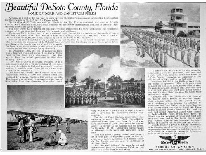
Military Base Conversions During World War I and II Florida was the site of many training bases. There were site characteristics that made Florida attractive especially to flight training. First, Florida is flat, which means no mountains to hit. Second, there is a lot of water, an attractive alternative to hitting the ground if something goes wrong. Third, there wasn’t a whole lot of population, so you had a choice of emergency landing sites and little population pressure. Finally, Florida’s government has always encouraged anyone to come to Florida that has money and often turns its back on things that may upset the environment or become problems later.
Though it was flat there were mishaps, Arcadia WW 1 top, Carlstrom (Arcadia in WW 2) left, and a typical scene at one of the training bases (Marianna) in WW 2. Three shapes of military airfields used in WW 2. The earliest type, left over from when planes were constructed of wood and canvas, used the X-shape to take advantage of wind. Many of these were never paved. The middle design is common to airfields built by the Navy in WW 2 and the design on the right was common to Army Air Corps (now the USAF). Generally, airfields grew in length as planes became larger and heavier.
What became of the bases? Opa-locka, site during WW 2. Notice that it incorporates the early and Navy design. Key West which was occupied by the government during WW 2.
Some of course are still airfields but many changed due to demand. Top Left: Witham Field in Stuart, Left: Del Mabry Field, now TCC in Tallahassee, Above: Bush Gardens was once Henderson Field the biggest airport in Tampa
Daytona Naval Airbase was converted to the Daytona Speedway, replacing the traditional beach racetrack. What types of infrastructure would make a base an attractive place to convert to another usage? Electric Lines Roads Water and Sewage Systems What would be a detriment to using an old military site?
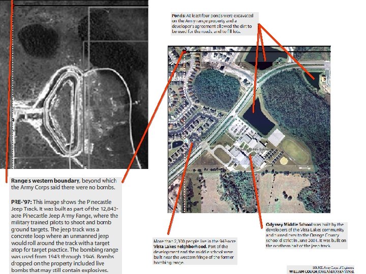
Gifts from Above Flagler Estates Odyssey Middle School was built on the northern portion of the Pinecastle Jeep bombing range. Among the munitions discovered in 2008: 1 100 -lb. concrete bomb 19 100 -lb. M 75 bombs 99 23 -lb. fragmentation bombs 12 20 -lb. fragmentation bombs 11 4. 5 -5 -inch air-to-ground rockets 3 incendiary bombs 10 rifle grenades 35 M 54 bombs 1 antitank rocket with detonator
To Review: • What is sequent occupance? – Is it something new? – What are site characteristics that make some places more likely to be converted? – In the modern world, what types of infrastructure would make a place more likely to be converted to a new use? – Name some cities that have palimpsests. – Give examples of local sites that have been converted to a new use.
Vocabulary Concepts • Comparative Advantage • Palimpsest • Infrastructure • Bid rent • Concentric Zone model and Sector model