Sem Dat A WebBased Interactive Flexible Translation Service

Sem. Dat: A Web-Based Interactive, Flexible Translation Service for Classification Systems and Taxonomies Center for e. Research & School of Environment University of Auckland William R. Smart Sina Masoud-Ansari Brandon Whitehead Tawan Banchuen Mark Gahegan

Overview • Problem and motivation • A quick tour • Ontology creation • Web app architecture • More snapshots/live demo (perhaps)

Motivation Kyoto Treaty | Kyoto Protocol carbon credits Landcare’s desire to support interoperable data Subset of Ph. D research
 • Eco. Sat •")
background data schemas and… • Land Cover Data Base (LCDB) • Eco. Sat • Land Use and Carbon Analysis System (LUCAS)

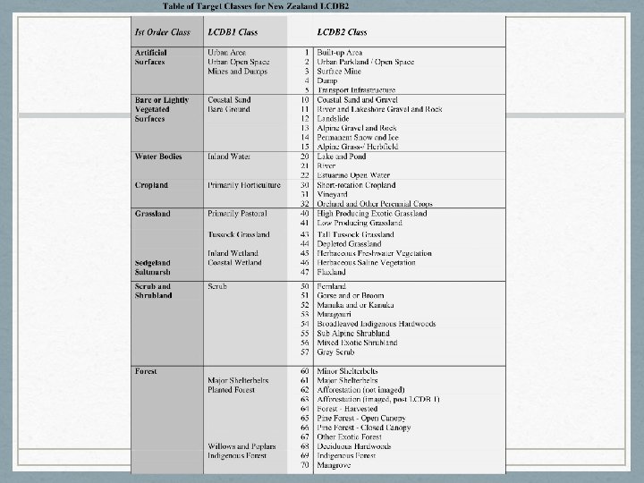
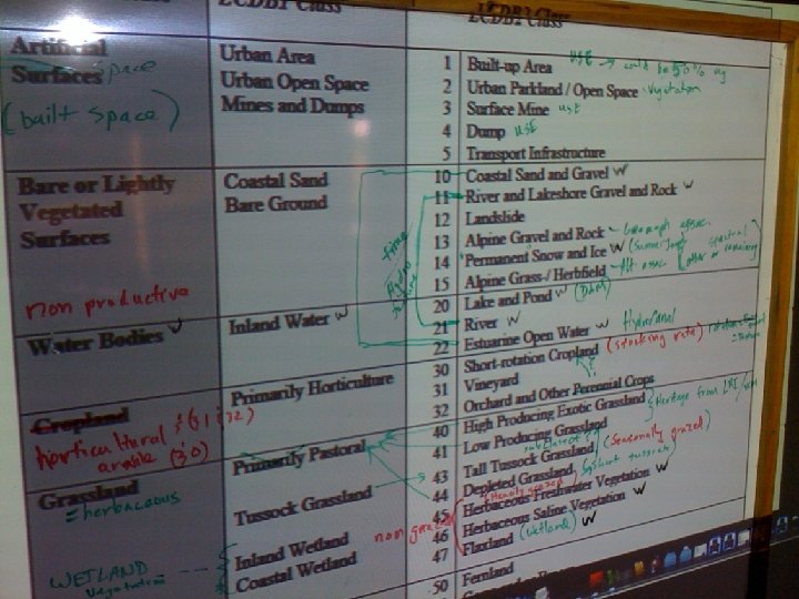
background LCDB • Three iterations • LCDB 1 • LCDB 2 • LCDB 1. 1 (or, LCDB 1 second edition) • Primarily for reporting on changes to land cover (1 ha. min. mapping unit) Source: Ministry for the Environment, 2004

background Eco. Sat • Maps ecosystem attributes from satellite • Regional scale – min. mapping unit 15 m • World leader in methods for removing the effect of topography from satellite imagery

background LUCAS • Team housed at Mf. E • Tasked with developing methods to meet the requirements of the Kyoto Protocol • Goal is to track and quantify changes in New Zealand use from 1990 to 2008

The specific problem we are solving • We have legends with no spatial data • . . . for which we want the full map • For example, the Kyoto Protocol • Worth a lot to have a classified map of NZ with the Kyoto Protocol classes as its legend

are they compatible? • Would an understanding of the semantic structure of each concept in each data store surface meaningful concept relationships? • Would meaningful concept relationships be helpful to decision makers? • Would meaningful concept relationships enhance our understanding of New Zealand’s carbon footprint?

http: //semdat. bestgrid. org

http: //semdat. bestgrid. org

http: //semdat. bestgrid. org

https: //wiki. auckland. ac. nz/display/knowcomp/Sem. Dat+Users+Manual

how? • Workshop! • Invite experts from each respective data source • Share concept development process (pitfalls, concrete and fuzzy concepts, etc. )
)")
An example: LCDB 1 and LCDB 2 (Land-cover database versions 1, 2(or 1 b)) • • • LCDB 2 • Matagouri • Mixed Exotic Shrubland • Orchard and Other Perennial Crops • PLANTED_FOREST • Other Exotic Forest • Manuka and or Kanuka • PRIM_PASTORAL • Mangrove • Landslide These databases largely come from the same source • SCRUB • Low Producing Grassland Yet, their legends render them incompatible • Major Shelterbelts • URBAN • Pine Forest - Closed Canopy • • For instance, we couldn’t easily compare some class between LCDB 1 and • Pine Forest - Open Canopy TUSSOCK • Surface Mine LCDB 2 • Tall Tussock Grassland • MINES_DUMPS We need a mapping • Transport Infrastructure • Urban Parkland/ Open Space • MANGROVE • Sub Alpine Shrubland • Short-rotation Cropland • COASTAL_SANDS • Permanent Snow and Ice • River • URBAN_OPEN_SPACE • River and Lakeshore Gravel and Rock • Lake and Pond • COASTAL_WETLANDS • Indigenous Forest • Built-up Area • INDIGENOUS_FOREST • Coastal Sand Gravel • Deciduous Hardwoods • INLAND_WETLANDS • Depleted Tussock Grassland • Broadleaved Indigenous Hardwoods • INLAND_WATER • Alpine Gravel and Rock • Vineyard • • • LCDB 1 PRIM_HORTICULTURAL
 • LCDB 1 • PRIM_HORTICULTURAL • PLANTED_FOREST")
Can we fix it? (yes we can) • LCDB 1 • PRIM_HORTICULTURAL • PLANTED_FOREST • PRIM_PASTORAL • SCRUB • URBAN • TUSSOCK • MINES_DUMPS • MANGROVE • COASTAL_SANDS • LCDB 2 • Matagouri • Mixed Exotic Shrubland • Orchard and Other Perennial Crops • Other Exotic Forest • Manuka and or Kanuka • Mangrove • Landslide • Low Producing Grassland • Major Shelterbelts • Pine Forest - Closed Canopy • Pine Forest - Open Canopy • Surface Mine • Tall Tussock Grassland • Transport Infrastructure • Urban Parkland/ Open Space • Sub Alpine Shrubland • Short-rotation Cropland • Permanent Snow and Ice • River and Lakeshore Gravel and Rock • Lake and Pond • Indigenous Forest • Built-up Area • Coastal Sand Gravel • Deciduous Hardwoods • Depleted Tussock Grassland • Broadleaved Indigenous Hardwoods • Alpine Gravel and Rock • Vineyard • Afforestation (not imaged) • Alpine Grass-/Herbfield • Build a mapping from one to other, or. . • Build an ontology which contains and links them • The mapping will fall out of the ontology naturally • URBAN_OPEN_SPACE • COASTAL_WETLANDS • INDIGENOUS_FOREST • INLAND_WETLANDS • INLAND_WATER • BARE_GROUND

Ontologies • An ontology is stored as a set of triples • Subject predicate object • John has. Colour Orange • Some predicates are special • John sub. Class. Of People • John same. As John • Our mapping could be an ontology directly • LCDB 2: River sub. Class. Of LCDB 1: Inland. Water • There also some very comprehensive ontologies available that relate many concepts together • eg Sweet • By making our mapping via an ontology we leverage: • Previously identified relationships between general concepts • Inference engines and data stores to hold our mapping
")
The system Spatial LCDB 2 Map 1 Legend Spatial Ontology Alignment (Brodaric’s Engine, GIN) LCDB 2 Spatial Hybrid Map Lucas Kyoto Legend LUCAS Map 2 Kyoto Legend (there is no map)

SNAPSHOTS/LIVE DEMO

Conclusions • Spatial data format is highly standardized • Legends can be also • The Sem. Dat site uses an ontology to relate a given virtual legend a spatial legend attached to a map. • Any legend well-connected to the ontology may be rendered as the legend of any other map with a legend that is connected to the ontology • The site allows multiple types of download • WMS • WFS • Shapefil • Chinese province – next test case (supports Madarin) • Ola – Workshop at GIScience?

• Technology choices Ontology storage/inference – • Sesame • Good choice • Map server – happy medium • Mapserver for WMS • Fast – mediation via SLD files • Geoserver for WFS/Shapefile • Flexible – mediation via features • Issues with memory yet to be sorted out • Map storage • Both postgis/postgresql and as shapefiles • Found postgis to be about four times slower for WMS • Site • Custom Javascript • Open. Layers (Javascript) for WMS • Server interface • PHP

Questions Tawan Banchuen, Ph. D t. banchuen@auckland. ac. nz http: //wiki. auckland. ac. nz (keyword: knowledge comp) http: //jira. auckland. ac. nz (knowledge computing project) NZ e. Research Symposium http: //www. eresearch. org. nz Eclipse RAP http: //www. eclipse. org/rap
- Slides: 24