Sedimentology Stratigraphy LIU Jun Some basic facts Sediments

Sedimentology & Stratigraphy LIU Jun

Some basic facts • Sediments and sedimentary rocks • 10% of the volume of the upper crust • 90% of the earth’s surface: 3/4 Earth’s land (30% of the surface) mantled with relatively thin (except in mountain systems) veneer of almost everywhere under water • 800~2000 m thickness if uniformly spread globally • Dates back to nearly 4 Ga, but most of the sediment and sedimentary rock at the surface is younger than 600 Ma, as result of burial and erosion. Oceanic crust, and hence the sediments overlie oceanic crust, are entirely younger than 200 Ma. Older oceanic sediments oregenic belts on the continents.

How to know? • Direct measurement from maps • drill-hole data • subsurface study using seismology • • Chemical methods • sea water, sedimentary rocks, earth’s crust • the overall abundance of a particular component (Na, K, Ca) that is dissolved in seawater • the amount of that constituent dispersed in whatever rocks were the ultimate source of that now dissolved component

What rock types are most abundant? • mudrock 63% sandstone 22% limestone 15% • direct observation and measurement of rock type visible in exposed sections • numerically juggling geochemical data comparing the composition of major sedimentary rock types with the composition of their likely ultimate source rocks
 Why feldspars")
What is the most abundant mineral in the Earth’s upper crust? (Feldspar) Why feldspars are scare in sedimentary rocks? (Weathering) KAl. Si 3 O 8+H+ feldspar Al 2 Si 2 O 5 (OH)+K + +H 4 Si. O 4 clay mineral (kaolinite) ions in solution Dissolved silica High feldspar content: source area, climate and topography, chemical weathering is not extensive (climate / high source relief) K-feldspar (common in continent crust, resist decomposition better)> plagioclase

Basic processes • • Weathering Transport Deposition Diagenesis

Weathering is the simple consequence of exposing pre-existing rocks to the conditions at the Eatrh’s surface: low temperature and pressure, organic activity, and chemically active substance such as water and atmospheric gases. Control: source composition, climate, drainage, topographical relief Physical weathering: Chemical weathering Disintegrating rock into clasts Dissolving constitutents Freeze-thaw Hydration and dehydration Insolation Hydrolysis Stress release Oxidation-reduction organic activity Simple solution
 Suspension Deposition: Stoke’s law of settling V=(ρs-ρf)gd 2/18μ= C D")
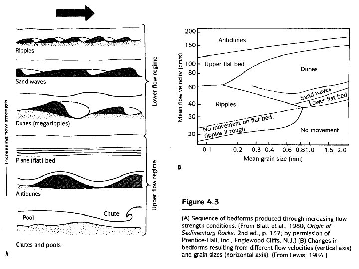
Transport Bedload (Traction, saltation) Suspension Deposition: Stoke’s law of settling V=(ρs-ρf)gd 2/18μ= C D 2 V (fall velocity) C (constant) D (diameter of the grains) (larger grains fall faster)

Grains principally moved by gravity, rather than simply being carried by the motion of fluid flow


Siliciclastic sedimentary rocks

Conglomerate and breccia 1 -2% Good indicator of provenance, depositional environment, paleogeography tectonic setting Classification: Composition of framework and matrix grains Intraformational Extraformational The proportion of matrix orthoconglomerate (matrix is 15% or less) paraconglomerate (diamictite, diamixtite)
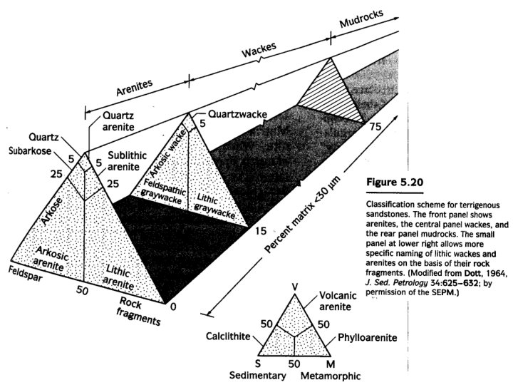

Occurrence Quartz arenites: many are shallow marine sands, others are subareal windblown dune deposits Stable continental craton to weathering Feldspathic (arkosic) arenite 40 -50% feldspar Orthoclase and microcline>plagioclase continent crust plagioclase: volcanic arc Typically coarser, less sorted, less well rounded Continental distension and the developed of fault-bounded, riftrelated grabens and half-grabens Lithic arenite 5 -50% rock fragments Subduction-related active magmatic arcs and collisional orogeny Wacke dark, hard Archean Waning turbidity current, submarine fan complexes

Mudrocks Siltstone mudstone claystone color • The obstacles to understanding mudrocks • Not well exposed • Mineral composition and texture cannot be studied easilily • Grain size data, sedimentary structures give little information • Historical reasons

Clay mineralogy reflect: provenance, diagenetic history and rock age, depositional setting Glauconites shallow marine surface Bentonite tool for correlation Black shale anaerobic • But clay minerals now present in a mudrock might be quite different from those present when it was deposited.

Siliciclastic Diagenesis Compaction; Cementation; authigenesis, recrystallization, and replacement Indicators for Maximum T and/or depth of burial of a rock Conodont color alteration Vitrinite reflectance Transformation of clay minerals Zeolite facies

• Facies- associated bodies of sediment or sedimentary rock distingushed on the basis lithologic and paleontologic characteristics that reflect the processes and environments of deposition and/or diagenesis Walther’s law- only those facies and paleoenvironments than can be observed beside each other today, or that are inferred to have been so related in the past, can be superimposed without break

Sedimentary environments Terrestrial • • • Alluvial fan Braided fluvial systems Meandering fluvial systems Lacustrine deposits Eolian deposits Coastal • Deltas • Peritidal • Barrier complexes (shoreface, foreshore, backshore, lagoons and tidal flats) Clastic marine and pelagic • Clastic shelf • Continental slope and rise • Pelagic Glacial
 Geometry")
How to recognize these environments? Diagnostic features • • Tectonic setting (associated systems) Geometry Typical sequence Sedimentology (composition, texture, sedimentary structure ) • Fossils
 ( free substitution of Mg 2+ for Ca")
Carbonate rocks • Calcite (rhombohedral form) ( free substitution of Mg 2+ for Ca 2+) calcite with >5% Mg. CO 3 is high. Mg calcite proportion of Mg increase with T (related to latitude and depth), and depends on Mg/Ca ratio of solution Organisms • Aragonite (orthorhombic) unstable warm-water carbonates <100 m water depth Organisms • Dolomite

Controls of carbonate deposition Ca 2++2 HCO 3 -=Ca. CO 3+H 2 O+CO 2 • • Temperature Pressure Degree of agitation Organic activity Sedimentary masking and clogging Light CCD a depth at which the rate of carbonate supply equals the rate of dissolution 3500~5500 m in the modern ocean lysocline (the depth where the rate of carbonate dissolution reaches a maximum)
 Varying development of microbial laminite, fenestrae (birds")
Carbonate environments • Peritidal (intertidal and supratidal) Varying development of microbial laminite, fenestrae (birds eye structure), dessication cracks, tepees, beds and nodules of anhydrite, tufas, evidence for hypersalinity (low diversity assemblage of organisms)and meteoric diagenesis /dolomitization • subtidal characterized by Organisms that are intolerant of elevated salinity and by the absence of evidence for subaerial exposure • Slope Interdtratification of ribbon limestones, nodular limestones, hemipelagic sediment (shale), contouritelayers, evidence for downslope sliding, breccias, floatstones and rudstone derived from an adjancent platform, winnowed lags, evidence for primary depositional dip (geopetal indicators), abundant open marine fauna • reefs and buildups Carbonate sediments tend to fill available space efficiently in shallow seas (producing shoaling upward successions) environment stress
 cherts deep water siliceous oozes nodular")
• Chert and siliceous sediment Bedded (primary) cherts deep water siliceous oozes nodular (replacement) cherts • Phosphorites • Organic-rich sediments (coal, petroleum, oil shale) • Chemical and nonepiclastic sedimentary rocks –Iron-rich (iron content >15%) –Evaporates Volanogenic sedimentary rocks

Stratigraphy • A discipline that is concerned with the description and interpretation of layered sediments and rocks, and especially with their correlation and dating. • Correlation is a procedure for determining the relative age of one deposit with respect to another. (Traditional) • The process of demonstrating the equivalence or correspondence of geographically separated parts of a geological unit is called correlation.
")
Variation in the intrinsic character or properties of sediments or rocks Lithostratigraphy (sedimentary properties) Biostratigraphy (strata of different ages contain different fossils) (Biozone) Magnetostratigraphy (Polarity Zone) Chemostratigraphy Sequence and seismic stratigraphy (interpretation of sediments and sedimentary rocks in a geometrical context) Matching the, fossil content, geophysical, geochemical properties of strata

Determinate the relative age of strata Nicolaus Steno Any succession of strata the oldest layer must have accumulated at the bottom, and successively younger layers above. Superposition, horizontality, lateral continuity The processes that control the production, transport, and accumulation of sediments are markedly episodic, so sedimentary record is fundamentally discontinuous

Rock unit Formation is the fundamental unit in lithostratigraphy It must have identifiable and distinctive lithic characteristics, and it must be mappable on the Earth’s surface or traceable in the subsurface. Group Formation Member Bed Geochronologic units Time Rock Eonthem Erathem Period System Epoch Series Age Stage GSSP (Global Stratotype Sections and Points) golden spike
 Assemblage")
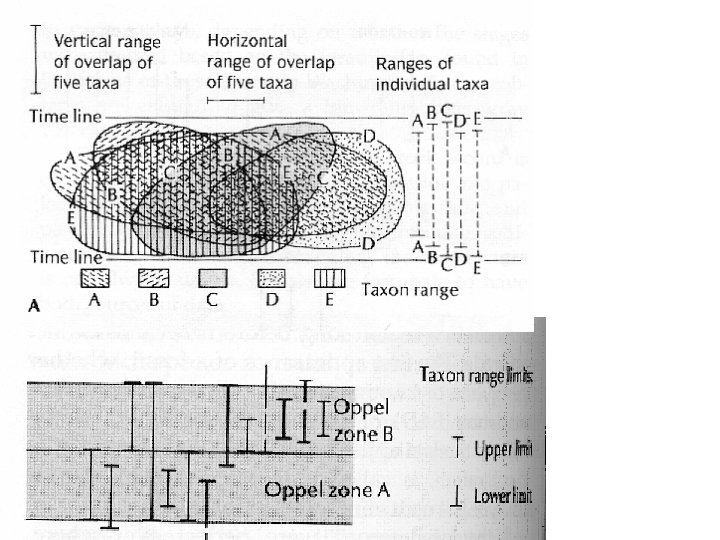
Biozones FAD: first appearance datum LAD: last appearance datum Interval zones (concurrent zone) Assemblage Zones Abundance Zone
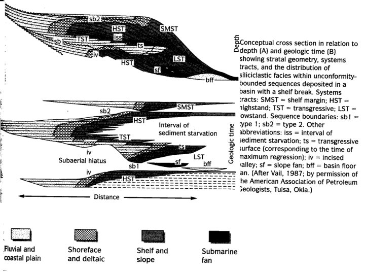

Sequences are defined on the basis of bounding uncomformities and correlative conformities rather than material characteristics or age Sequence stratigraphy is fundamentally not a system for stratigrahic classification, but a procedure for determining how sediments accumulate. Systems tracts Does not imply sedimentation at any particular stand of sea level Important term Onlap downlap offlap (bypassing or erosion)
 Regression:")
Transgression: shoreline move landward (relative rises in sea level or land subsides tectonically) Regression: shoreline away from the land excess sediment supply from the land (Progradation), sea retreat or land is tectonically uplifted Most of the deposits formed during a sea-level rise are regressive sequences that had biult out and coarsened upward during the progradation of nearshore facies. time-transgressive: The rock units or facies are of different ages in different places,

SCIENCE VOL 302 12 DECEMBER 2003 1931
- Slides: 40