Sedimentary Basin Analysis Basin Analysis Basin analysis is

Sedimentary Basin Analysis ﺩکﺘﺮ کﺮﺩی

Basin Analysis Basin analysis is the integrated study of sedimentary basins as geodynamical entities. Basin analysis requires an understanding of many diverse geological specialties and an ability to asses the relationships between various types of geological disciplines such as:

Stratigraphy • Lithostratigraphy • Biostratigraphy • Chemostratigraphy • Magnetostratigraphy • Seismic-stratigraphy Sequence Stratigraphy • Sequence boundaries • Depositional sequence • System tracts (LST, TST, HST) • Sea-level history

Sedimentology • Depositional environments • Facies Models Petrography • Relation between rock composition, climate and tectonic settings and diagenetic history Paleogeography Tectonic • Basin classification in relation to tectonic setting (e. g. Cratonic, Foreland, Back Arc, etc. • Subsidence history
 • Inorganic (reservoir characterization relation to reduction and")
Geochemistry • Organic (source rock evaluation) • Inorganic (reservoir characterization relation to reduction and generation of secondary porosity) • Thermal history Geophysics • Structural analysis • Stratigraphy Sources of Data • Surface • Subsurface

Application in Petroleum Exploration • To evaluate Distribution of source rock • To evaluate Distribution of reservoir rock • To evaluate Distribution of cap rock • To evaluate the time of source rock maturation • To evaluate the time of petroleum generation and migration • To evaluate the time of trap formation and petroleum accumulation

Sedimentary basin The official definition of a sedimentary basin is: a low area in the Earth’s crust, of tectonic origin, in which sediments accumulate. Sedimentary basins range in size from as small as hundreds of meters to large parts of ocean basins. The essential element of the concept is tectonic creation of relief, to provide both a source of sediment and a relatively low place for the deposition of that sediment. Tectonics is needed to make sedimentary basins, but the record of the basin itself is sedimentary.
 Crust Outermost layer of the Earth, composed of")
Compositional zonation of the Earth 1) Crust Outermost layer of the Earth, composed of alumino-silicates with relatively low density rocks. It makes up only one percent of the earth's mass. 2) Mantle A dense, hot layer of semi-solid rock between the crust and the outer core that is composed mainly of ferro-magnesium silicates. 3) Core Liquid outer core and solid inner core, composed of iron and nickel.

Oceanic crust Composed of mafic rocks, which is rich in iron and magnesium, ~60% of the surface of the Earth, thin with thickness of 4 -20 km, average density of 2900 kg/m 3, short lifespan (<150 Ma) § First layer: composed of unconsolidated or poorly solidated sediments, generally up to 0. 5 km thick § Second layer: composed of pillow lavas and submarine products of submarine eruptions § Third layer: composed of gabbros and peridotites

Continental crust Composed of igneous, sedimentary, and metamorphic rocks which forms the continents and the areas of shallow seabed close to their shores, known as continental shelves, with thickness ranging from 30 -70 km § Upper layer: composed of Granites, granodiorites, and diorites overlain by sedimentary rocks, with thickness of 20 -25 km and density of 2500 -2700 kg/m 3 § Lower layer: composed of basalt and granulites, with density of 28003100 kg/m 3

Study of the Earth interior • • Volcanic rocks derived by melting of the mantle Mantle exposed by mid-oceanic ridge spreading Laboratory experiments on rock materials Geophysical investigations (speed of seismic waves passing through the various layers)

Moho At the crust-mantle boundary, seismic P wave velocities increase markedly that reflect a corresponding increase in rock density. This horizon is known as Mohorovicic discontinuity or Moho.

Mantle Ø The interior of the Earth is chemically divided into layers due to phase transitions. Ø Earth's mantle is a silicate rocky shell that constitutes about 84% of Earth's volume. Ø It is predominantly solid but in geological time it behaves like very viscous liquid. v Upper mantle: Up to 680 km + 20 km • Olivine • Spinel v Lower mantle: Up to 2900 km, with an increasing density with depth • Perovskite and Mg. O

Core • The outer core: A liquid layer about 2, 266 km thick composed of iron and nickel which lies above the inner core and below the mantle. As the Earth rotates, the liquid outer core spins, creating the Earth's magnetic field. • The inner core: A primarily solid ball with a radius of about 1, 220 km (about 70% of the Moon’s radius), and with the same temperature as the surface of the Sun (approximately 5430 °C). It is consist of iron and nickel. The inner core is kept in the solid state because of the extreme pressure from the other layers.

Mechanical or Rheological zonation of the Earth • Lithosphere: Rigid outer shell of the Earth, comprised of the crust and upper portion of the mantle that behaves elastically. The lithosphere remains rigid for very long periods of geologic time in which it deforms elastically and through brittle failure. The lithosphere is broken into tectonic plates. • Asthenosphere: Below the lithosphere that deforms viscously and accommodates strain through plastic deformation.

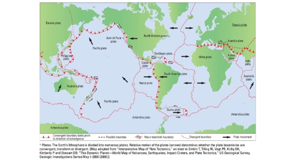
Plate tectonic • Large convective cells in the mantle circulate heat and may have major role in lithospheric break-up that drive plate tectonic processes. • Earth surface divided up into about a dozen major lithospheric plates. • Plate motions create sedimentary basins.

Plate boundaries • Divergent/constructive (moving away from each other, mid-ocean ridge spreading centers of the ocean basins) • Convergent/destructive (move toward one another and collide) • Conservative/transform: (moving parallel to each other)
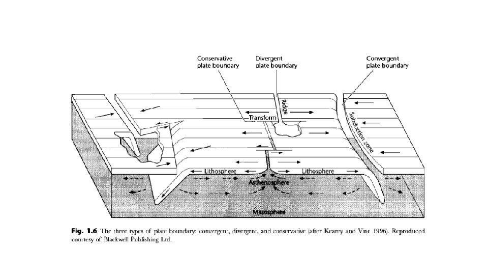

From divergent to convergent margins In general, the average rate of recent plate movements is usually from 1 to 2 mm/yr (Komatina 2004).

How might one classify sedimentary basins? Here’s a list of some of the important criteria that could be used, ranging from more descriptive at the top of the list to more genetic at the bottom of the list: § nature of fill § geometry § paleogeography § tectonic setting Nowadays sedimentary basins are classified by plate-tectonic based on Dickinson’s work 1974.
 • • • Oceanic")
Five major basin types based on plate-tectonic (After Dickinson, 1974) • • • Oceanic Basins Rifted continental margins Arc-trench systems Suture belts Intracontinental basins
- Slides: 22