Seasonal Climate Forecast Verification February April 2021 Issued

Seasonal Climate Forecast Verification February – April 2021 Issued: May 20, 2021 Contact: Pete Parsons, ODF Meteorologist 503 -945 -7448 or peter. gj. parsons@oregon. gov Oregon Department of Agriculture (ODA) - Oregon Department of Forestry (ODF). Production support: Diana Walker, Jacob Cruser; Andy Zimmerman; Julie Waters

Format and Purpose: A side-by-side comparison of the “Seasonal Climate Forecast” vs. what (Actually Occurred) is done for both the 1 -month & 3 -month forecasts. * n The accuracy of each forecast is reviewed, and the need for analog-year updates is examined. n This is part of an ongoing assessment of the utility of this forecast method. ** n *Utilizes 1981 -2010 long-term averages
/(Actual) Forecast Upper-Air Anomalies n Actual Upper-Air Anomalies")
February 2021 (Forecast Issued January 21, 2021)/(Actual) Forecast Upper-Air Anomalies n Actual Upper-Air Anomalies Anomalous ridging was both predicted (left) and observed (right) in the Gulf of Alaska, which opened to door for cold air dumps to slide southward across western and central Canada and to also impact the Pacific
/(Actual) Forecast Temperatures Actual Temperatures Data courtesy of")
February 2021 (Forecast Issued January 21, 2021)/(Actual) Forecast Temperatures Actual Temperatures Data courtesy of the National Centers for Environmental Information (NCEI)
/(Actual) Forecast Precipitation Actual Precipitation Data courtesy of")
February 2021 (Forecast Issued January 21, 2021)/(Actual) Forecast Precipitation Actual Precipitation Data courtesy of the National Centers for Environmental Information (NCEI)
/(Actual) n Large swings between cold and mild")
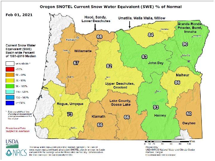
February 2021 (Forecast Issued January 21, 2021)/(Actual) n Large swings between cold and mild periods, but overall temperatures will stay closer to average. (After a relatively mild start, an Arctic cold snap hit during the second week, bringing well-below-average temperatures and damaging snow/ice to the northern valleys. Temperatures returned to near average late in the month. ) A “forecast hit. ” n Mountain snowpacks should be near-or-above average by month’s end. (After a slow start to the season, mountain snowpacks recovered in February to above average north and near average south – see next two slides. ) A “forecast hit. ”
/(Actual) Forecast Upper-Air Anomalies n Actual Upper-Air Anomalies")
March 2021 (Forecast Issued February 18, 2021)/(Actual) Forecast Upper-Air Anomalies n Actual Upper-Air Anomalies The highly anomalous upper-level troughing that was expected (left) over the northern U. S. was weaker and centered over the Pacific Northwest. Generally, a “forecast hit” for Oregon, which is our area of interest.
/(Actual) Forecast Temperatures Actual Temperatures Data courtesy of")
March 2021 (Forecast Issued February 18, 2021)/(Actual) Forecast Temperatures Actual Temperatures Data courtesy of the National Centers for Environmental Information (NCEI)
/(Actual) Forecast Precipitation Actual Precipitation Data courtesy of")
March 2021 (Forecast Issued February 18, 2021)/(Actual) Forecast Precipitation Actual Precipitation Data courtesy of the National Centers for Environmental Information (NCEI)
/(Actual) n Colder-than-normal conditions. (Temperatures were below average")
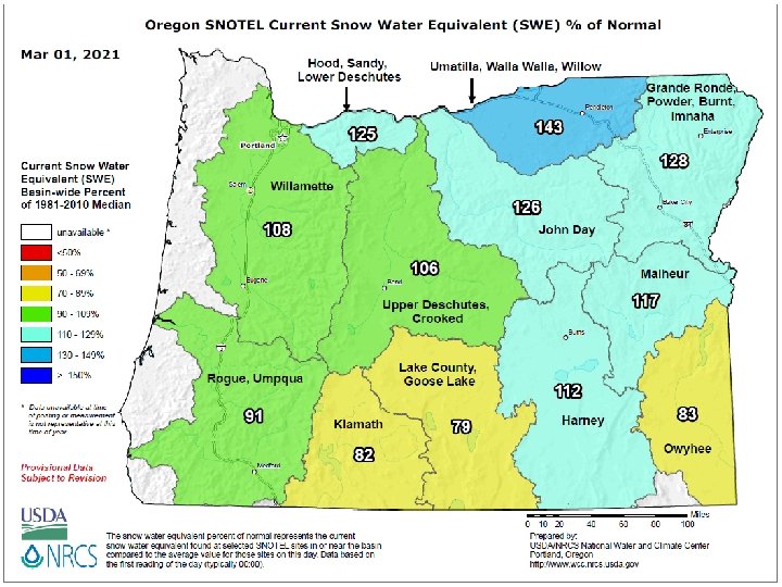
March 2021 (Forecast Issued February 18, 2021)/(Actual) n Colder-than-normal conditions. (Temperatures were below average statewide, with the greatest negative departures across the western zones. ) A “forecast hit. ” n Near-average precipitation. Mountain snowpacks should be near or above normal at month’s end. (Precipitation was below average statewide. Mountain snowpacks finished the month above normal north and near-to-below normal south – see next slide. ) A partial “forecast hit. ”
/(Actual) Forecast Upper-Air Anomalies n Actual Upper-Air Anomalies")
April 2021 (Forecast Issued March 18, 2021)/(Actual) Forecast Upper-Air Anomalies n Actual Upper-Air Anomalies A large negative anomaly was predicted (left) over western Canada and extending into the NW U. S. The observed pattern (right) showed a weaker negative anomaly, centered over central Canada, with anomalous ridging
/(Actual) Forecast Temperatures Actual Temperatures Data courtesy of")
April 2021 (Forecast Issued March 18, 2021)/(Actual) Forecast Temperatures Actual Temperatures Data courtesy of the National Centers for Environmental Information (NCEI)
/(Actual) Forecast Precipitation Actual Precipitation Data courtesy of")
April 2021 (Forecast Issued March 18, 2021)/(Actual) Forecast Precipitation Actual Precipitation Data courtesy of the National Centers for Environmental Information (NCEI)
/(Actual) n 1971 and 2008 analogs had relatively")
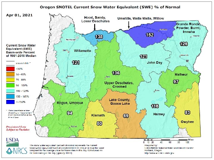
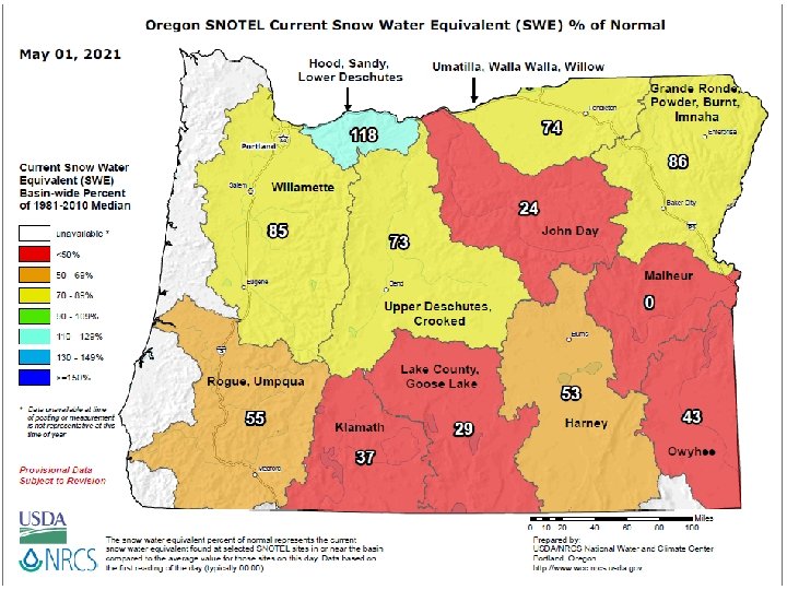
April 2021 (Forecast Issued March 18, 2021)/(Actual) n 1971 and 2008 analogs had relatively cool Aprils, but April of 1996 was warm. A blend skews colder than average. (April started cool, but a strong upper-level ridge brought well-above-average temperatures at mid-month. ) A “forecast miss. ” n Precipitation near or above average north and near or below average south. Mountain snowpacks peaking above average north and below average south. (April was unusually dry. The combination of warm and dry weather caused mountain snowpacks to melt at a faster rate then normal…see next slide. ) A “forecast miss. ”
/(Actual) Forecast Upper-Air Anomalies n Actual")
February – April 2021 (Forecast Issued January 21, 2021)/(Actual) Forecast Upper-Air Anomalies n Actual Upper-Air Anomalies Anomalous upper-level ridging was predicted (left) and observed (right) in the Gulf of Alaska. The anomalous troughing predicted for western Canada and the northern U. S was actualized but at a weaker level than
/(Actual) Forecast Temperatures Actual Temperatures Data")
February – April 2021 (Forecast Issued January 21, 2021)/(Actual) Forecast Temperatures Actual Temperatures Data courtesy of the National Centers for Environmental Information (NCEI)
/(Actual) Forecast Precipitation Actual Precipitation Data")
February – April 2021 (Forecast Issued January 21, 2021)/(Actual) Forecast Precipitation Actual Precipitation Data courtesy of the National Centers for Environmental Information (NCEI)
/(Actual) n Temperatures slightly below average,")
February – April 2021 (Forecast Issued January 21, 2021)/(Actual) n Temperatures slightly below average, especially along the coast. (February was quite cold, especially north. Temperatures stayed cool through March into April, then rebounded to above normal in mid-April, especially west. Overall, temperatures were below normal. ) A “forecast hit. ” n Precipitation near average. Mountain snowpacks peaking near or above average. (Above-average precipitation in February, with Arctic air and significant valley snow/ice north. March brought average precipitation, but April was very dry. Overall, precipitation was below average. Snowpacks peaked above average north & slightly below average south but melted quickly, due to a dry and warm April. ) Forecast was too wet.

Updated Mid-Month Your Feedback is Welcome! Sign-up for Email notification of updates at: https: //oda. fyi/Subscribe. SCF Contact: Pete Parsons, ODF Meteorologist at 503 -945 -7448 or peter. gj. parsons@oregon. gov https: //www. flickr. com/photos/canonshott/sets/72157654242713168
- Slides: 24