Seafloor Instruments Techniques Marine Geophysical Techniques Marine Geological


- Slides: 25

Seafloor Instruments & Techniques • • • Marine Geophysical Techniques Marine Geological Techniques Drilling Navigation Mapping

I. Marine Geophysical Techniques • Seismic Methods • Seismic Reflection Profiling – Multichannel Seismic Profiling – Echo Sounding – SONAR – Side-scan and Multibeam Sonar • Seismic Refraction • • Marine Magnetics Marine Gravity Marine Heat Flow Logging

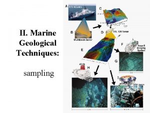
II. Marine Geological Techniques • Coring – Piston corers – Box corers – Gravity corers • • • Dredging Drilling Sondes and CTDs Bottom cameras Submersibles

Navigation Methods • Astronomical • Sighting on Land Features • Radio Methods including LORAN • Satellite Navigation, GPS • Transponder Navigation

Mapping - GIS • GIS (Geographic Information System) is an tool for ocean exploration. • the way it gathers and analyzes information. • Given enough data, a GIS can, in fact, create a virtual ocean inside of a computer.

I. Marine Geophysical Techniques

Seismic Methods sound energy: (measured in frequency - cycles per second - Hertz) – sound energy is transmitted from the surface, – travels to the bottom & is reflected or refracted from various interfaces, – travels back to the surface & is received by transducers or hydrophone arrays, & – converted to electric signals & recorded by computer or graphically

Seismic Reflection Profiling • uses Large Energy Sources (Explosives, Sparkers, or Airguns) • frequencies are lower than echo sounding (10's to 1000's of Hz) • Subbottom penetration is greater (100 to 12000 m) • Simple seismic profiling only uses essentially one receiver – to convert resulting time section to depth section, velocities must be obtained from some other means

• Multichannel Seismic Profiling uses a large number of receivers & requires considerable computer processing – velocities are obtained during this processing so depth sections can be produced directly – increased signal to noise ratio

SONAR SOund NAvigation and Ranging • used to find and identify objects in water • also to determine water depth: bathymetry

Echo Sounding - Bathymetry • 40 k. Hz - Fathometer - shallow water (<100 m) only • 12 k. Hz - PDR - Bathymetry in deep water (up to 12 km) – no subbottom penetration • 3. 5 k. Hz - PDR - Bathymetry in deep water – up to 100 m of subbottom penetration

Side-scan and Multibeam Sonar • to search for and detect objects on the seafloor. – Side scan sonar continuously records the return echo, thus creating a “picture” of the sea floor. – This picture is made up of dark and light areas. • Side-scan sonar requires three components – a towfish that sends and receives acoustic pulses, – a transmission cable attached to the towfish that sends data to the ship, and – the ship’s processing computer.

Seismic Refraction • used to obtain velocities & geometries of deep layers • sound energy travels parallel to layers during part of its travel path • requires stationary receiver - either another ship or a SONOBUOY, that transmits signals back to the ship – refracted sound waves from a particular layer form a straight line on plots of time of received waves vs. distance between shot & receiver – the slope of the line is proportional to the velocity of sound of the layer through which the sound waves are passing

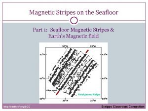
Marine Magnetics Magnetomers • at sea, variations in the strength of the Earth's magnetic field usually are caused by oceanic crust that is either normally polarized or reversely polarized – the magnetic character of seamounts can indicate whether the seamount is underlain by magnetic or nonmagnetic materials

Marine Gravity • Gravimeter – essentially a weight on the end of a spring – the length of the spring varies as the strength of the Earth's gravity field varies • variations of the Earth's gravity field can occur because of varying density of rocks beneath the Earth's surface

Multi Sensor Core Logger (MSCL) • • • P-wave Velocity Magnetic Susceptibility Electrical Resistivity Gamma Density Colour Spectrophotometer

II. Marine Geological Techniques

II. Marine Geological Techniques • Coring – Piston corers – Box corers – Gravity corers • • • Dredging Drilling Sondes and CTDs Bottom cameras Submersibles

Piston corers • most useful in obtaining sediment for marine studies • a tight-fitting piston inside core barrel configured to be held at or near the sediment water interface creates a suction that holds the sediment in the core barrel and • reduces friction between the core barrel & the sediment • cores are generally 10 -20 m long • are essentially undisturbed

Box corers • large rectangular box with basal blades for obtaining short (<0. 75 m), but voluminous (up to 2 x 105 cm 3), surface sediment samples – a standard 20 m-long piston core obtains about 1 x 105 cm 3 of sediment

Gravity corers • • free fall into bottom generally shorter (<5 m) more disturbed than piston cores) less complicated, more easily & quickly deployed • Many more cores can be obtained in short time

Dredging • a dredge is basically a big rectangular or circular metal frame enclosed at the bottom by a chain bag • it is used to get rock samples from the bottom

Sonde and CTD • Profiling the Water Column for profiling and monitoring water conditions in industrial and wastewater effluents, lakes, rivers, wetlands, estuaries, coastal waters, and the open ocean • have multiple sensors record a range of water quality data. • Multi-parameter water monitoring systems simultaneously measure – a range of biological and physical properties in both fresh and seawater environments. • They operate with the push of a button, store data in memory, and communicate with computers.

Bottom cameras • • Light and the Color of Water Visible light penetrates into the ocean, but once past the sea surface, light is rapidly weakened by scattering and absorption. The more particles that are in the water, the more the light is scattered. This means that light travels farther in clear water. Absorption can be caused by phytoplankton which use the light for photosynthesis, particulate matter in the water, dissolved material in the water.

Submersibles • • used to carry scientists to the bottom for direct observations & detailed sampling & deployment of instruments – example, ALVIN – owned by NSF, ONR & NOAA (National Ocean & Atmosphere Administration), & managed by WHOI – NAUTILE • French • can dive to 4000 m & operate for up to 8 hours (limited by batteries), although there is enough oxygen on board to remain submerged for 3 days • 2 scientists & a pilot in a 6 -foot sphere • manipulator arms for recovering samples & deploying instruments • e. photographic record obtained by externally mounted bottom cameras (35 mm still & black & white video) & internal hand-held still & video cameras
 National geophysical data center
 Geophysical fluid dynamics
 Gravity method of geophysical exploration
 Reservoir geophysical corporation
 Latitude correction gravity formula
 Tsunami sa basilan at romblon
 Active instruments and passive instruments
 Pressure measuring devices
 Seafloor spreading
 Seafloor spreading theory
 Sciencechannel.com/activate
 Diagram of seafloor spreading
 Spreading
 Continental drift michael sammartano
 Seafloor spreading
 Seafloor spreading vocabulary
 Seafloor deformation monitoring
 Seafloor spreading material at trenches
 Seafloor spreading images
 Ocean graphic organizer
 Sea floor spreading drawing
 Seafloor spreading animation
 Age of ocean
 Harry hess and seafloor spreading
 Seafloor
 What is one piece of evidence of seafloor spreading?
