Sculpture by Isaac Cordal in Berlin Politicians discussing

Sculpture by Isaac Cordal in Berlin: Politicians discussing global warming Earth 2 Class: with Michael Passow Saturday, September 28, 2019 Can Coastal Cities Cope with SLR? Examples from NYC, US and abroad. Klaus H. Jacob Lamont-Doherty Earth Observatory -- jacob@ldeo. columbia. edu

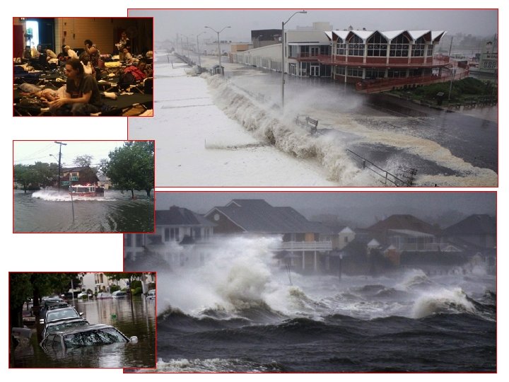
Maria-Puerto Rico Harvey – Houston TX Santa Rosa, CA, Fires IRMA - FL

CC Adaptation is a form of Risk Management. So what is Risk ? Potential for Future Losses => $$/year or $$/event Vulnerability (0 -1) RISK Hazard (annual probability or for a given event) Exposure (Value of Assets, $$) Risk = Hazard x Assets x Vulnerability

CC Adaptation a form of Risk Management. Some Risk is Management Options: So what is Risk ? Vulnerability Environ. Standards Engineering Codes RISK Hazard Zoning Exposure (Assets)

NYC: Many Excellent Studies & Reports, but Sparse Action & $$’s available to date Climate Change and a Global City The Potential Consequences of Climate Variability and Change Before Sandy: Metro East Coast (MEC) July 2001 MEC 2001 MTA 2009 NPCC-1 2010 Clim. AID 2011 ====> Sandy Oct 29 -30, 2012 NPCC-1. 5 2013 NPCC-2 2015 SIRR June 11, 2013 After Sandy: 2015
. S 1 S")
Red 100 -y flood in 2000 (surge of ~ 8 ft). S 1 S 2 Yel 100 -y flood in 2040 s, with +2 ft SLR Grn 100 -y flood in 2080 s, with +4 ft SLR S 3 Clim. AID, Chapter 9: Transportation. Jacob et al. 2011 (1 year before Sandy)
 + NYC Economic Loss (~")
Clim. AID 2011 Forecast: Potential MTA Damage ($10 B) + NYC Economic Loss (~ $50 B) = Clim. AID, Chapter 9: Total Loss of Transportation. Jacob et Billion al. 2011 ~ $ 60

NPCC 1 -2010 -Recommended Adaptation Steps 1. Identify current & future climate hazards 8. Monitor & Reassess 2010 2. Conduct Inventory of Built Assets 2011 7. Implement Adaptation Plans 3. Characterize Risk of CC on Built Assets “SAN DY” 6. Link Strategies to Development Cycles http: //onlinelibrary. wiley. com/doi/10. 1 111/j. 1749 -6632. 2010. 05324. x/pdf 2012 4. Develop Initial Adaptation Strategies 5. Identify Opportunities for Coordination 2013

SANDY

SANDY Oct 29, 2012 ~ 5 days 11. 0 ft 8. 9 ft 0. 2%/yr BFE 1 day+51. 4 min 11. 3 ft 2. 5 ft

2012 Sandy eerily verified Clim. AID’s 2011 Predicted Impacts, but with a Major Exception: In the 36 hours prior to Sandy’s Landfall, MTA removed sensitive signal & control systems from subway tunnels that Clim. AID had forecast would flood, and post-Sandy MTA reinstalled these signals unharmed by salt water. This measure shortened the subway recovery time by at least 10 days, and thereby reduced NYC’s economic loss by ~ $20 B or more !! NOTE: NYC’s Daily Economic Output is > $4 B / Day !!

NPCC 2015 3 Basic Modes of SLR Adaptation: • Protection • Accommodation • Managed Retreat SIRR June 11, 2013
 Forecasts 10” 2’ 6” 4’ 10”")
9’ 6” NPCC 2015 Sea Level Rise (SLR) Forecasts 10” 2’ 6” 4’ 10” 6’ 3” SLR, inches 80 70 60 6’ 9” NPCC 2 2015 ARIM NPCC 3 2019 90% 5 ft 50 75% 40 3 ft 30 25% 25 10% 20 10 0 2000 Extrapolation of 20 th-Century SLR Trend 2020 2040 2060 2080 2100

The elevations flooded in 2012 by a 700 -yr event may be reached in 2090 by a 10 -yr event: 70 -fold risk increase! Elevations in feet above NAVD 1988 at Battery Tide Gauge, NYC. 20 18 700 -yr 16 500 -yr 14 Sandy 12 10 500 -yr 8 100 -yr 6 10 -yr 4 100 -yr 700 -yr 10 -yr Sandy Elevation in 2012 Flood Elevations as a function of time for the 90 -percentile SLR scenario and for 4 flood return periods: 10 -yr flood 100 -yr flood 500 -yr flood 700 -yr flood 2 0 1982 2002 2022 2042 2062 2082 2102 2122

Sandy Flood Level at Battery above MLLW NPCC 2 Sea Level Rise 2000 to 2100 (6 ft) (90 -percentile) Modified from SIRR June 2013

NPCC 2 Future Coastal Flood Risk Maps 18
 and % Flooded, for Three Flood Scenarios 25. 3% 33.")
NYC Street Length (miles) and % Flooded, for Three Flood Scenarios 25. 3% 33. 8% 100 -Yr Storm with 2 -ft SLR with 4 -ft SLR Street Length, miles 10. 6% Flooded Street Length Dry Street Length Total: ~ 8, 632 miles

Some Proposed: 4 New York Barriers London’s Thames Barriers Rotterdam Flood Barriers Some Propose NY Barriers: Army Corps of Engineers 2 -Barrier proposal. Barriers protect against storms, but are unsustainable with respect to SLR. Why ?

A Dutch Cartoonist’s View of SLR Defenses: Is that we plan for New Amsterdam?

Residual Risk: Katrina New Orleans, Aug 2005.

Beyond NYC & US: The Global Context: Coastal urban agglomerations with populations more than 8 million in 2010 Source: UN data

Dubai, UAE

New Songdo City, South Korea. Source: Greg Lindsay, The New Urbanism, Feb 2010

Sustainable Resilience: • Sustainable design provides resilience now while minimizing liabilities for future generations => Intergenerational equity and justice. • Plan for “Higher Ground”: avoid putting new assets into current and future flood plains near sea level. Migrate willing coastal communities that are at risk out of harm’s way to higher elevations. Create (National & Local) Funds for Community Transformation (Carbon Tax!! Cap & Trade, e. g. CA) • Sustainable designs: => self-adaptive designs: floating structures, where feasible.

3 Basic Modes of Adaptation: • Protection • Accommodation • Strategic Relocation (to high ground)

Possible Future Concept: Transform Evacuation Zones A into Parks and Marshes and Raise the Floor Area Ratio in Non-Evacuation Zones

Oakwood Beach Community in Staten Island, NYC
: 48 Teams Applied, 10 Admitted , 6 Winners BIG Team")
RBD (Rebuild by Design): 48 Teams Applied, 10 Admitted , 6 Winners BIG Team (Lower Manhattan Big U) Penn. Design/Olin (Hunts Point Interboro Team (Nassau County South Shore) Bronx, NYC) MIT/ZUS/Urbanisten (Meadowlands NJ)
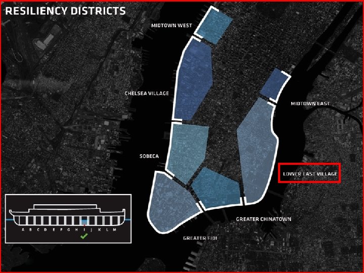

Planned Levee/Park, Lower East Side of Manhattan Unresolved Issue: How to get rid of severe rain fall from behind the levee, given NYC’s combined sewer system. 32

North Broad Street Canal Maiden Lane Inlet New Amsterdam

New Amsterdam ca 1660 X In Modern Downtown Manhattan: Can we have Canals again? Amphibian Water Taxis? and High Lines crossing Canaland Water Street? Br oa d St re et Ca na l X X Looking down on Ducks Floating on Wall Street ? !

Summary • NYC is vulnerable under current climate conditions • Climate Change & Sea Level Rise amplify future coastal storm flood risks. • Protection by Levees & Barriers is effective only for limited times (2100? ) & only postpones transformative measures. • Accommodation: Accommodation submersible infrastructure and floating structures provide some flexible adaptation paths. • Strategic Relocation to higher ground is the most sustainable adaptation strategy (>2100), but needs Comprehensive Planning & Financing Starting NOW !! • NYC’s efforts (e. g. SIRR, RBD, NY Rising) provide some temporary resilience to about the 2050 s or 80 s. But more transformative, truly sustainable solutions are needed.

No k n a h T ! u o Y Timing can be crucial !!.
- Slides: 36