
Scientific Taiwan Flood Prevention and Disaster Mitigation Former

- Slides: 33
Scientific Taiwan Flood Prevention and Disaster Mitigation Former Chair Professor Robert Y. Lai General Education Center Tatung University Former Chairman, the Board of National Applied Research Laboratory Unless noted, the course materials are licensed under Creative Commons Attribution-Non. Commercial-Share. Alike 2. 5 Taiwan (CC BYNC-SA 2. 5) 1 The presentation is powered by Powered. Templates. com
Outline About NARL, Taiwan Homeland Security Technology developed at NARL • • Taiwan Earthquake Loss Estimation System (TELES) Flood Mitigation Grid Decision Support System for Early Warning 3 D GIS Taiwan Platform on Natural Disaster Management Support Concluding Remarks Scientific Taiwan Flood Prevention and Disaster Mitigation 2
About NARL The National Applied Research Laboratories (NARL) was established in June 2003. NARL is a non-profit organization comprising of nine research laboratories which branched out from National Science Council (NSC), Taiwan. NARL primary mission is to – Establish R&D platforms – Support academic researches – Promote frontier science and technology – Foster high-tech manpower Scientific Taiwan Flood Prevention and Disaster Mitigation 3/33
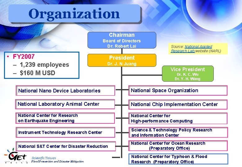
Organization Chairman Board of Directors Dr. Robert Lai • FY 2007 – 1, 239 employees – $160 M USD Source: National Applied Research Lab website (NARL) President Dr. J. N Juang Vice President Dr. K. C. Wu Dr. Y. H. Wang National Nano Device Laboratories National Space Organization National Laboratory Animal Center National Chip Implementation Center National Center for Research on Earthquake Engineering National Center for High-performance Computing Instrument Technology Research Center Science & Technology Policy Research and Information Center National S&T Center for Disaster Reduction National Center for Ocean Research (Preparatory Office) Scientific Taiwan Flood Prevention and Disaster Mitigation National Center for Typhoon 4/28 & Flood Research (Preparatory Office)
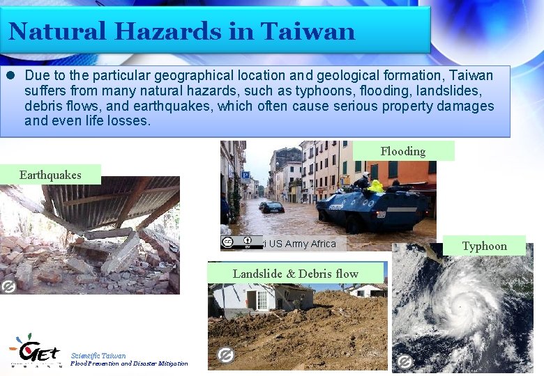
Natural Hazards in Taiwan l Due to the particular geographical location and geological formation, Taiwan suffers from many natural hazards, such as typhoons, flooding, landslides, debris flows, and earthquakes, which often cause serious property damages and even life losses. Flooding Earthquakes Wiki US Army Africa Typhoon Landslide & Debris flow Scientific Taiwan Flood Prevention and Disaster Mitigation 5/28
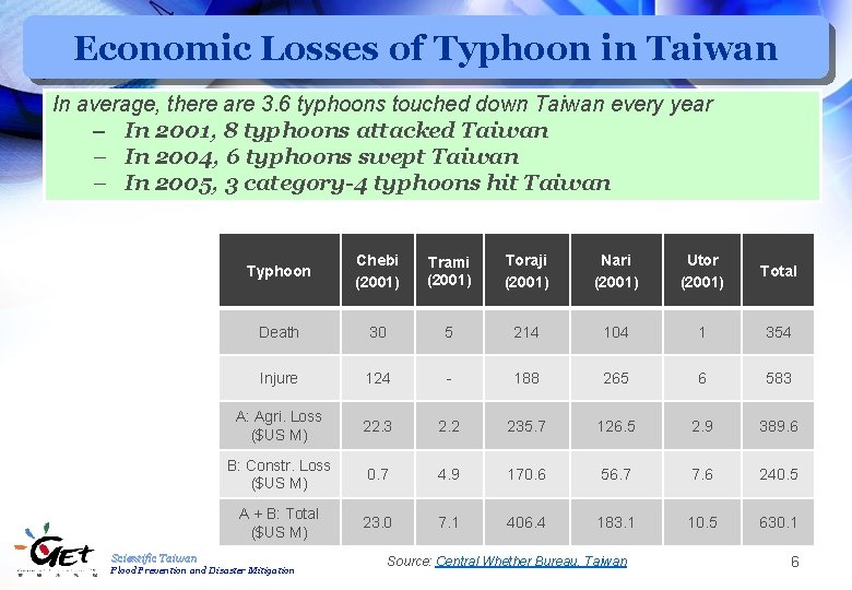
Economic Losses of Typhoon in Taiwan In average, there are 3. 6 typhoons touched down Taiwan every year – In 2001, 8 typhoons attacked Taiwan – In 2004, 6 typhoons swept Taiwan – In 2005, 3 category-4 typhoons hit Taiwan Typhoon Chebi (2001) Trami (2001) Toraji (2001) Nari (2001) Utor (2001) Total Death 30 5 214 104 1 354 Injure 124 - 188 265 6 583 A: Agri. Loss ($US M) 22. 3 2. 2 235. 7 126. 5 2. 9 389. 6 B: Constr. Loss ($US M) 0. 7 4. 9 170. 6 56. 7 7. 6 240. 5 A + B: Total ($US M) 23. 0 7. 1 406. 4 183. 1 10. 5 630. 1 Scientific Taiwan Flood Prevention and Disaster Mitigation Source: Central Whether Bureau, Taiwan 6
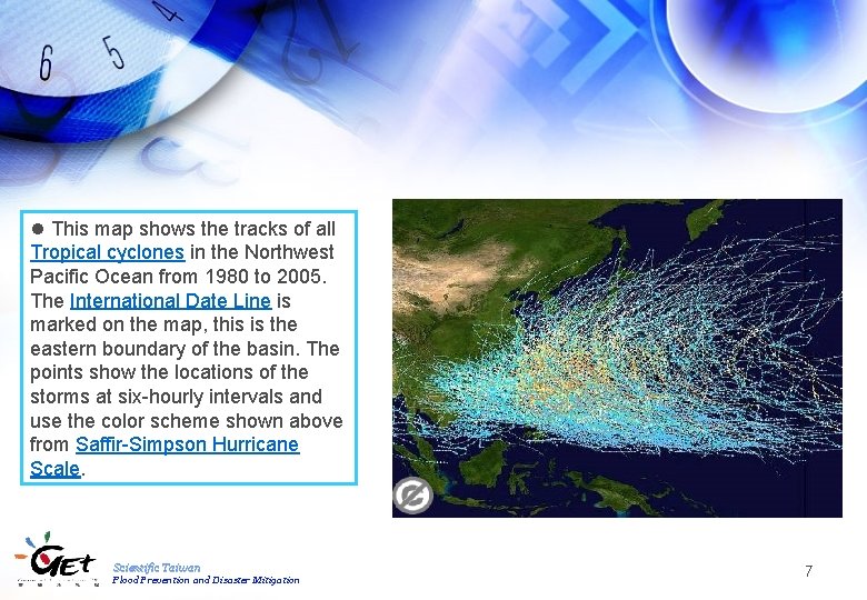
l This map shows the tracks of all Tropical cyclones in the Northwest Pacific Ocean from 1980 to 2005. The International Date Line is marked on the map, this is the eastern boundary of the basin. The points show the locations of the storms at six-hourly intervals and use the color scheme shown above from Saffir-Simpson Hurricane Scale. Scientific Taiwan Flood Prevention and Disaster Mitigation 7
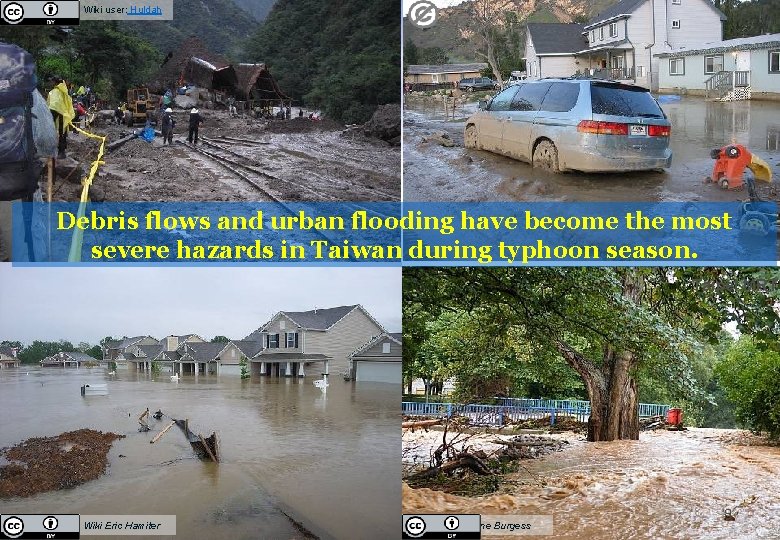
Wiki user: Huldah Debris flows and urban flooding have become the most severe hazards in Taiwan during typhoon season. Taipei MRT Scientific Taiwan Prevention and Disaster Mitigation Wiki. Flood Eric Hamiter Wiki Anne Burgess 8
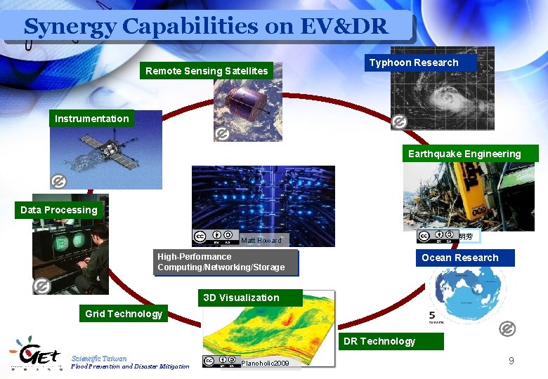
Synergy Capabilities on EV&DR Remote Sensing Satellites Typhoon Research Instrumentation Earthquake Engineering Data Processing Wiki 松岡明芳 Wiki Matt Howard High-Performance Computing/Networking/Storage Ocean Research 3 D Visualization Grid Technology DR Technology Scientific Taiwan Flood Prevention and Disaster Mitigation Wiki Planoholic 2009 9
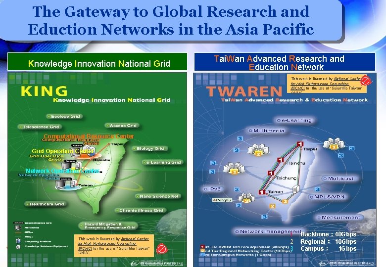
The Gateway to Global Research and Eduction Networks in the Asia Pacific Knowledge Innovation National Grid Tai. Wan Advanced Research and Education Network This work is licensed by National Center for High Performance Computing (NCHC) for the use of “Scientific Taiwan” ONLY. Computational Resource Center Grid Operation Center Network Operation Center This work is licensed by National Center for High Performance Computing (NCHC) for the use of “Scientific Taiwan” Scientific Taiwan ONLY. Flood Prevention and Disaster Mitigation 1 2 3 Backbone: 40 Gbps Regional: 10 Gbps Campus: 1 Gbps 10
Grid Applications Ecology Grid Scenario for Ecogrid Flood Mitigation Grid Medical Grid l. Asthma Grid Scientific Taiwan Flood Prevention and Disaster Mitigation 11
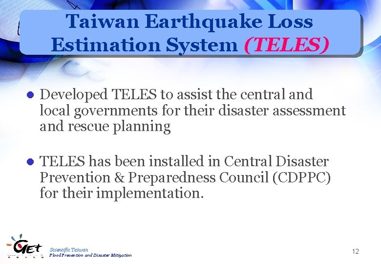
Taiwan Earthquake Loss Estimation System (TELES) l Developed TELES to assist the central and local governments for their disaster assessment and rescue planning l TELES has been installed in Central Disaster Prevention & Preparedness Council (CDPPC) for their implementation. Scientific Taiwan Flood Prevention and Disaster Mitigation 12
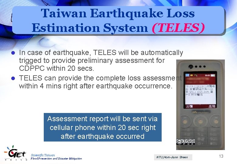
Taiwan Earthquake Loss Estimation System (TELES) In case of earthquake, TELES will be automatically trigged to provide preliminary assessment for CDPPC within 20 secs. l TELES can provide the complete loss assessment within 4 mins right after earthquake occurrence. l Assessment report will be sent via cellular phone within 20 sec right after earthquake occurred Scientific Taiwan Flood Prevention and Disaster Mitigation NTU, Horn-Jiunn Sheen 13
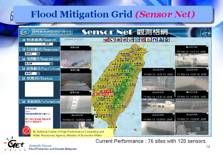
Flood Mitigation Grid (Sensor Net) By National Center of High-Performance Computing and Water Resources Agency, Ministry of Economic Affairs Current Performance : 76 sites with 120 sensors Scientific Taiwan Flood Prevention and Disaster Mitigation 14
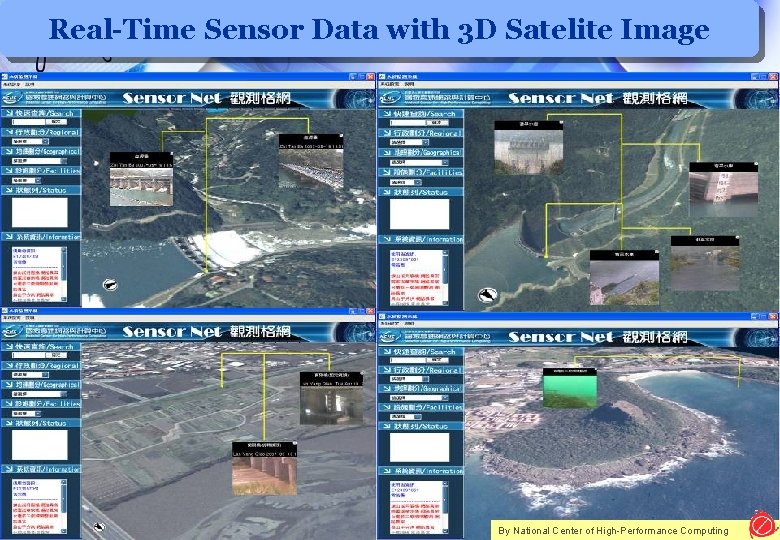
Real-Time Sensor Data with 3 D Satelite Image Scientific Taiwan Flood Prevention and Disaster Mitigation 15/28 By National Center of High-Performance Computing
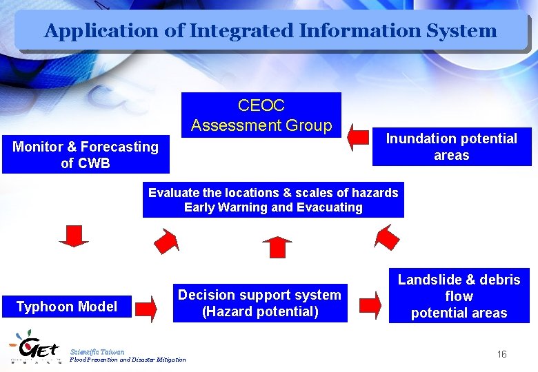
Application of Integrated Information System CEOC Assessment Group Monitor & Forecasting of CWB Inundation potential areas Evaluate the locations & scales of hazards Early Warning and Evacuating Typhoon Model Decision support system (Hazard potential) Scientific Taiwan Flood Prevention and Disaster Mitigation Landslide & debris flow potential areas 16
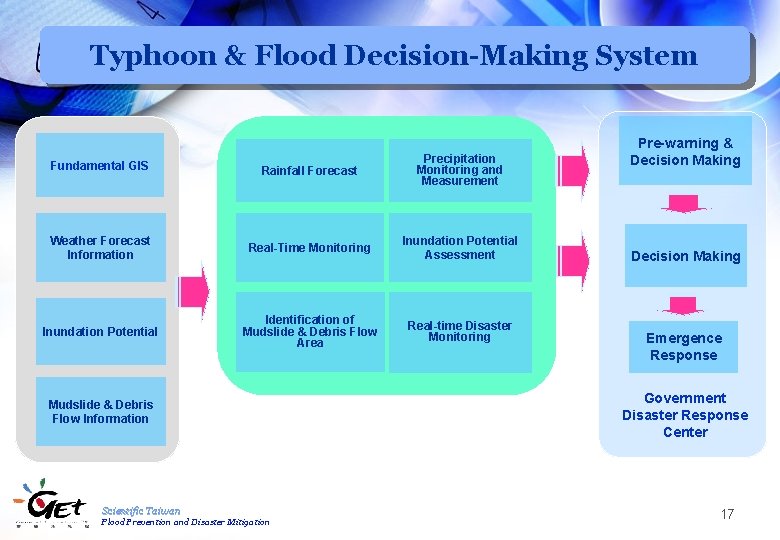
Typhoon & Flood Decision-Making System Fundamental GIS Rainfall Forecast Precipitation Monitoring and Measurement Weather Forecast Information Real-Time Monitoring Inundation Potential Assessment Inundation Potential Identification of Mudslide & Debris Flow Area Real-time Disaster Monitoring Mudslide & Debris Flow Information Scientific Taiwan Flood Prevention and Disaster Mitigation Pre-warning & Decision Making Emergence Response Government Disaster Response Center 17
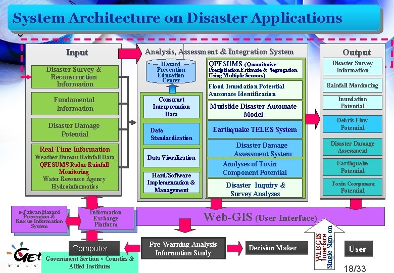
System Architecture on Disaster Applications Input Fundamental Information Disaster Damage Potential Hazard Prevention Education Center Construct Interpretation Data Standardization Precipitation Estimate & Segregation Using Multiple Sensors) Information Exchange Platform Computer Scientific Taiwan Government Section、Counties & Flood Prevention and Disaster Mitigation Allied Institutes Rainfall Monitoring Flood Inundation Potential Automate Identification Inundation Potential Mudslide Disaster Automate Model Debris Flow Potential Earthquake TELES System Real-Time Information Weather Bureau Rainfall Data QPESUMS Radar Rainfall Monitoring Water Resource Agency Hydroinformatics Disaster Survey Information QPESUMS (Quantitative Data Visualization Hard/Software Implementation & Management Disaster Damage Assessment System Analyses of Toxin Component Potential Disaster Damage Assessment Disaster Inquiry & Survey Analyses Toxin Component Earthquake Potential Web-GIS (User Interface) Pre-Warning Analysis Information Study Decision Maker WEBGIS Interface Single Sign-on Disaster Survey & Reconstruction Information e-Taiwan Hazard Prevention & Rescue Information System Output Analysis, Assessment & Integration System User 18/33
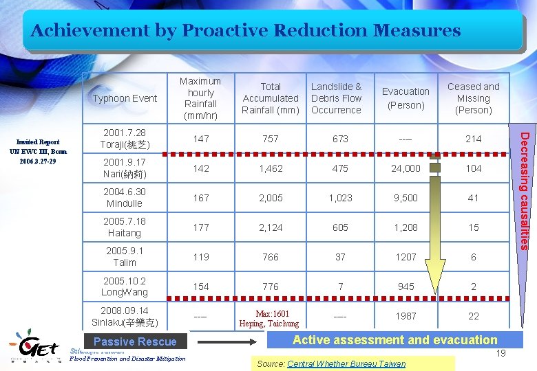
Achievement by Proactive Reduction Measures Total Accumulated Rainfall (mm) 2001. 7. 28 Toraji(桃芝) 147 757 2001. 9. 17 Nari(納莉) 142 2004. 6. 30 Mindulle Evacuation (Person) Ceased and Missing (Person) 673 ---- 214 1, 462 475 24, 000 104 167 2, 005 1, 023 9, 500 41 2005. 7. 18 Haitang 177 2, 124 605 1, 208 15 2005. 9. 1 Talim 119 766 37 1207 6 2005. 10. 2 Long. Wang 154 776 7 945 2 2008. 09. 14 Sinlaku(辛樂克) ---- Max: 1601 Heping, Taichung ---- 1987 22 Passive Rescue Landslide & Debris Flow Occurrence Active assessment and evacuation Scientific Taiwan Flood Prevention and Disaster Mitigation Decreasing causalities Invited Report UN EWC III, Bonn 2006. 3. 27 -29 Typhoon Event Maximum hourly Rainfall (mm/hr) 19 Source: Central Whether Bureau Taiwan
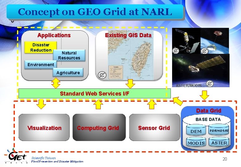
Concept on GEO Grid at NARL Applications Disaster Reduction Existing GIS Data Natural Resources FORMOSAT III Environment Agriculture ASTER/MODIS Standard Web Services I/F Data Grid BASE DATA Visualization Computing Grid Scientific Taiwan Flood Prevention and Disaster Mitigation Sensor Grid DEM FORMOSAT MODIS ASTER 20
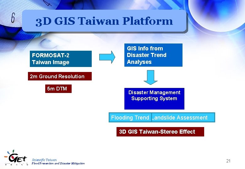
3 D GIS Taiwan Platform FORMOSAT-2 Taiwan Image GIS Info from Disaster Trend Analyses 2 m Ground Resolution 5 m DTM Disaster Management Supporting System Flooding Trend Landslide Assessment 3 D GIS Taiwan-Stereo Effect Scientific Taiwan Flood Prevention and Disaster Mitigation 21
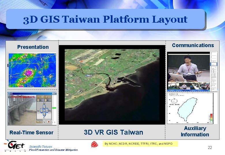
3 D GIS Taiwan Platform Layout Communications Presentation Real-Time Sensor Scientific Taiwan Flood Prevention and Disaster Mitigation 3 D VR GIS Taiwan Auxiliary Information By NCHC, NCDR, NCREE, TTFRI, ITRC, and NSPO 22
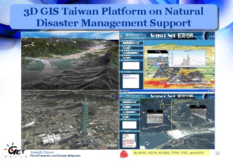
3 D GIS Taiwan Platform on Natural Disaster Management Support 、 Scientific Taiwan Flood Prevention and Disaster Mitigation By NCHC, NCDR, NCREE, TTFRI, ITRC, and NSPO 23
Concluding Remarks Natural disaster (typhoon, flood, and earthquake in particular) is one of critical homeland security issues in Taiwan. The implementation of NARL’s core technologies encompassing synergy of high-resolution satellite image, virtual reality computing, grid computing as well as disaster mitigation technology demonstrates a practical solution with the social impacts for the natural disaster management. NARL is willing to work together with international community on development of homeland security technology. Scientific Taiwan Flood Prevention and Disaster Mitigation 24
References Central Weather Bureau, Ministry of Transportation and Communication, (交通 部中央氣象局) http: //www. cwb. gov. tw/ Katrina Hurricane News l 美國卡崔娜颶風(Katrina)災害事件初步分析報告 http: //ncdr. nat. gov. tw/newsletter 2/001/Katrina. pdf l 颶風:KATRINA http: //library. thinkquest. org/05 aug/01412/lite/chinese/naturaldisasters/ hurricane/casestudy. html 921 Earthquake news (921集集大地震報導) http: //www. arch. ncku. edu. tw/921/index. htm National Science and Technology Center for Disaster Reduction (國家災害防 救科技中心) http: //ncdr. nat. gov. tw/chinese/default. asp South Asia Earthquake (News) http: //www. epochtimes. com/b 5/5/11/3/n 1106784. htm Scientific Taiwan Flood Prevention and Disaster Mitigation 25
References l National Center for Research on Earthquake Engineering (NCREE) , National Applied Research Laboratories (NARL) (國家實驗研究院國家地震 程研究中心) http: //www. narl. org. tw/tw/tech/company/? company_id=6 l National Science and Technology Center for Disaster Reduction (NCDR), National Applied Research Laboratories (NARL) 國家實驗研究院國家災害防救科 技中心 http: //www. narl. org. tw/tw/tech/company/? company_id=10 l National Disasters Prevention and Protection Commission (行政院災害防救委員 會) http: //www. ndppc. nat. gov. tw/ l Flood Control Command Center, 10 th River Management Office, Water Resources Agency, Ministry of Economic Affairs (經濟部水利署第十河川局防洪指 揮中心) http: //www. wra 10. gov. tw/eng/index. html l Video: No. 1 Flood Prevention and Disaster Mitigation http: //www. narl. org. tw/tw/multimedia/ Scientific Taiwan Flood Prevention and Disaster Mitigation 26
Scientific Taiwan Flood Prevention and Disaster Mitigation 27
Popular Science Books l Nano-technology reference books and experimental kids for K 12 students l Reference books for K-12 teachers and university students ˉ Animated cartoon, interactive video game, and elearning materials for elementary and junior high school students ˉ Comic books for students in elementary schools ˉ Textbooks for students in senior high schools, junior high schools, and elementary schools 28
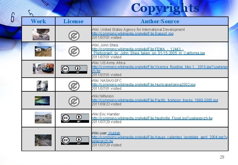
Copyrights Work License Author/Source Wiki: United States Agency for International Development http: //commons. wikimedia. org/wiki/File: Egepg 1. jpg 2011/07/01 visited Wiki: John Shea http: //commons. wikimedia. org/wiki/File: FEMA_-_12443__Photograph_by_John_Shea_taken_on_01 -15 -2005_in_California. jpg 2011/07/01 visited Wiki: US Army Africa http: //commons. wikimedia. org/wiki/File: Vicenza_flooding_Nov. 1, _2010. jpg? uselang= zh-tw 2011/07/01 visited Wiki: NASA/GSFC http: //commons. wikimedia. org/wiki/File: Hurricane. Kenna 2002. jpg 2011/07/01 visited Wiki Nilfanion http: //commons. wikimedia. org/wiki/File: Pacific_typhoon_tracks_1980 -2005. jpg 2011/08/23 visited Wiki Eric Hamiter http: //commons. wikimedia. org/wiki/File: Nashville_Flood. jpg? uselang=zh-tw 2011/07/29 visited ` Wiki user: Huldah http: //commons. wikimedia. org/wiki/File: Aguas_calientes_landslide_april_2004. jpg? u selang=zh-tw 2011/07/29 visited 29
Copyrights Work License Author/Source Wiki John Shea http: //commons. wikimedia. org/wiki/File: FEMA_-_12450__Photograph_by_John_Shea_taken_on_01 -15 -2005_in_California. jpg? uselang=zh-tw 2011/07/29 visited Wiki Anne Burgess http: //commons. wikimedia. org/wiki/File: Fochabers_Floods_2009_(1)_-_geograph. org. uk__1473506. jpg? uselang=zh-tw 2011/07/29 visited Wiki Greg Goebel http: //commons. wikimedia. org/wiki/File: Weather_Satellite. jpg 2011/07/28 visited Wiki NASA http: //commons. wikimedia. org/wiki/File: Soyuz. TMA_instrumentation%26 propulsion_module_blank. png 2011/07/28 visited SSGT. ROBERT S. THOMPSON, USAF http: //commons. wikimedia. org/wiki/File: Cobra_Dane_data_processing_center. jpg 2011/07/28 visited Wiki Matt Howard http: //commons. wikimedia. org/wiki/File: Nanoscience_High-Performance_Computing_Facility. jpg 2011/07/28 visited Exploring Taiwan Geographical Environment and Resources 30
Copyrights Work License Author/Source Wiki Planoholic 2009 http: //commons. wikimedia. org/wiki/File: Plano. RC 1. gif 2011/07/28 visited Original image from the Naval Research Laboratory cropped by Nilfanion http: //commons. wikimedia. org/wiki/File: Typhoon_Tanya_1999. jpg? uselang=zh-tw 2011/07/28 visited Wiki 松岡明芳 http: //commons. wikimedia. org/wiki/File: Hanshin-Awaji_earthquake_1995_343. jpg 2011/07/28 visited Wiki User: Quizimodo http: //commons. wikimedia. org/wiki/File: World_ocean_map. gif 2011/07/28 visited This work is licensed by National Center for High Performance Computing (NCHC) for the use of “Scienfic Taiwan” ONLY. The copyright belongs to NCHC and GET does not have the authorization right. Copyright privileges have to be negotiated with the copyright owner separately. Exploring Taiwan Geographical Environment and Resources 31
Copyrights Work License Author/Source NTU, Horn-Jiunn Sheen This work is licensed by National Center for High Performance Computing (NCHC) and Water Resources Agency, Ministry of Economic Affairs for the use of “Scienfic Taiwan” ONLY. The copyright belongs to NCHC and GET does not have the authorization right. Copyright privileges have to be negotiated with the copyright owner separately. This work is licensed by National Center for High Performance Computing (NCHC) for the use of “Scienfic Taiwan” ONLY. The copyright belongs to NCHC and GET does not have the authorization right. Copyright privileges have to be negotiated with the copyright owner separately. Wiki Heinz Lohmann http: //commons. wikimedia. org/wiki/File: TAIWAN_Karte_Gross. jpg 2011/07/28 visited Wiki NASA/JPL http: //commons. wikimedia. org/wiki/File: Seasat. jpg 2011/07/29 visited Wiki NASA http: //commons. wikimedia. org/wiki/File: Aura_satellite. jpg? uselang=zh-tw 2011/07/29 visited Exploring Taiwan Geographical Environment and Resources 32
Copyrights Work License Author/Source Wiki U. S. Navy http: //en. wikipedia. org/wiki/File: Ti. PS_lg. jpg 2011/07/29 visited This work is licensed by NCHC, NCDR, NCREE, TTFRI, ITRC, and NSPO for the use of “Scienfic Taiwan” ONLY. The copyright belongs to NCHC and GET does not have the authorization right. Copyright privileges have to be negotiated with the copyright owner separately. 、 Exploring Taiwan Geographical Environment and Resources This work is licensed by NCHC, NCDR, NCREE, TTFRI, ITRC, and NSPO for the use of “Scienfic Taiwan” ONLY. The copyright belongs to NCHC and GET does not have the authorization right. Copyright privileges have to be negotiated with the copyright owner separately. 33