SCIENCE 1206 UNIT 2 Weather Dynamics Weather Dynamics


 � � The albedo (ability to reflect light) of a material")


 � Similar concentration to")
 Temperature is much higher. (avg. ~ 30 o.")


 on Earth. � ~")
")


 Solar heating of the oceans near the")


 on “A Global Weather Model” – pg.")


 High-Orbit Satellites Orbit at around 36000 km above the equator. � Provide images")
 Low-Orbit Satellites At about 1000 km above the poles. � Gather data used")


 Formation of a Low Pressure System (Depression (1) Front forms between cold")


- Slides: 108
SCIENCE 1206 UNIT 2: Weather Dynamics
Weather Dynamics: The study of how the motion of water and air cause weather patterns. � The main components of Earth that affect weather are the atmosphere, the land forms, and the various forms of water (solid, liquid, and gas). �
Weather – the set of environmental conditions encountered from one day to the next. � Climate – the set of environmental conditions averaged over many years. � Example of a weather description: “It’s raining today. ” � Example of a climate description: “It often rains in October. ” �
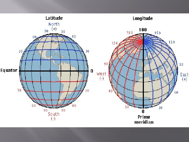
Global Geography Terms: � � � Longitude: the angle measured east or west of the 0 o line, which passes through Greenwich, England. Lines of longitude run from pole to pole. Latitude: the measured north or south of the equator. Equatorial Region: area between the Tropics of Cancer and Capricorn Polar Regions: areas north of the Arctic Circle and south of the Antarctic Circle. Mid-latitude Regions: areas between the tropics and polar regions.
Methods of heat transfer that distribute energy around the Earth:
1. Radiation: The transfer of energy by waves. � Radiation does not require a medium. � Visible light is only one member of the electromagnetic spectrum. � Some other waves from this spectrum include microwaves, Xrays, infrared waves, etc. �
2. Conduction The transfer of energy through the collision of particles. � E. g. frying pan � Some materials are better conductors of heat than others. � E. g. Metals conduct heat better than rock or sand. �
3. Convection � The transfer of energy vertically by movement of particles in a fluid. (water or atmosphere)
4. Advection � The transfer of energy horizontally by movement of particles in a fluid. (water or atmosphere)
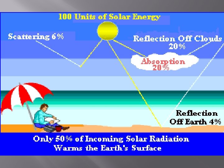
Solar Energy � � � The Sun is Earth’s main source of electromagnetic radiation. Not all solar energy reaching Earth’s atmosphere actually reaches the planet. Much is reflected back into space. (fig. 4, pg. 506) A certain amount is also reflected from the Earth’s surface, depending on the surface features.
Solar Energy (cont’d) � � The albedo (ability to reflect light) of a material will determine the amount of energy reflected. clean snow – high albedo black soil – low albedo Any material that absorbs a high percentage of radiant energy is called a heat sink. (e. g. oceans) Substances that make good heat sinks have high heat capacities.
Specific Heat Capacity The measure of how much heat one gram of a substance requires to raise its temperature by 1 o Celsius. � (Fig. 5, pg. 506 ) �
Latent Heat � � � The term “latent” means hidden. When a substance changes state, it absorbs or releases energy without changing temperature. Latent Heat of Fusion (Melting) – the amount of heat energy required to change a unit mass of a substance from a solid to a liquid. Latent Heat of Vaporization – the amount of heat energy required to change a unit mass of a substance from a liquid to a gas.
The Atmosphere � � � Consists of air and moisture that surrounds the Earth. Common atmospheric gases: oxygen (21%), nitrogen (78%), carbon dioxide, ozone and water vapor. Density depends on height above sea level. (most dense at sea level) Altitude is height above sea level. The atmosphere is thickest above the equator – warmer air takes up more space because it expands (less dense).
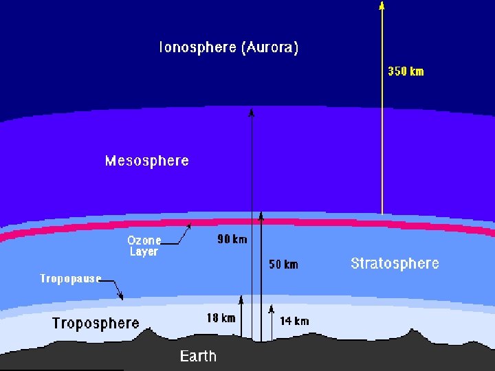
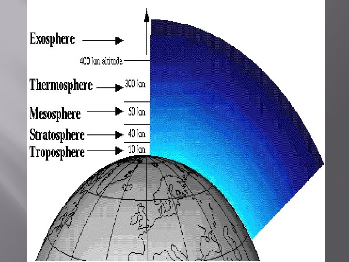
� � The atmosphere has a number of layers, each with its own properties As the altitude above Earth proceeds, we move into different layers.
The Layers of The Atmosphere:
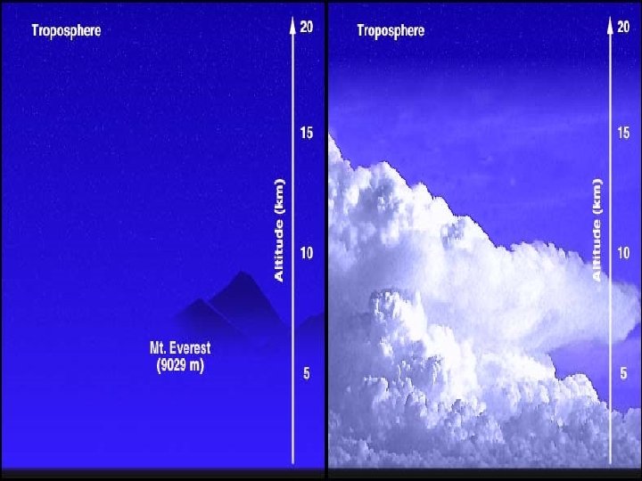
1. Troposphere � � � Layer closest to the Earth’s surface; it extends to an altitude of about 16 km at the equator and about 8 km at the poles. Contains most of the atmosphere’s moisture, and most of our weather systems/patterns. As the altitude increases in the troposphere, the temperature decreases 6 o. C per km.
2. Tropopause � � � Very thin layer that separates the troposphere from the stratosphere. The temperature increases due to the slightly greater amount of ozone present. Ozone absorbs more ultraviolet radiation causing the temperature increase.
3. Stratosphere � � � Contains very little moisture and extends for some 50 km. It exists from about 12 -60 km of altitude above Earth’s surface. It is a warm layer as it contains more ozone than any other layer, and protects the Earth from UV radiation.
4. Mesosphere This is the middle layer. (meso means middle) � Similar concentration to other layers with the exception of ozone and water vapor. � Very cold, with temperatures reaching as low as -75 o. C. � Layer extends from about 50 to 80 km. �
5. Thermosphere (a. k. a. Ionosphere) Temperature is much higher. (avg. ~ 30 o. C) � Higher temperature is due to x-ray absorption. � The radiation causes this layer to become ionized, which produces the aurora borealis (northern lights). � Layer extends from 80 to ~500 km. �
6. Exosphere � Very thin outer layer of very little atmosphere. � Most common element is hydrogen. � Temp. is extremely cold, and is often considered part of outer space.
Temperature Gradient � The change in temperature over a distance. � The troposphere has a temperature gradient of -60 C per 1000 m or 1 km(vertical distance upward)
Pressure Gradient Pressure changes across a set distance. A pressure gradient can be vertical or horizontal. � Closed lines on a weather map can indicate a pressure gradient. To show a high pressure gradient (resulting in high winds), lines are bunched together. �
Atmospheric Pressure � � � The pressure the air exerts as gravity pulls it toward the Earth. Atmospheric pressure is greatest at sea level where the air molecules are closer together. Atmospheric pressure generally decreases with altitude but falling/rising air will also affect atmospheric pressure. Atmospheric pressure is measured in kilopascals. (See text p. 512, fig 4(a)) The average atmospheric pressure at sea level is 100 k. Pa. Complete # 2, 3, 4, 5, and 6 on pg. 513.
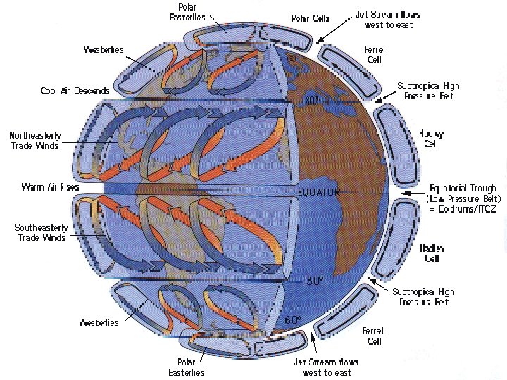
Prevailing Winds � � Wind is a movement of air in the atmosphere. Prevailing winds affect large areas/weather around the world. They are a result of: - differences in temperature /pressure from the equator to the poles, causing air to move - rotation of the Earth The apparent change in direction of a moving mass in a rotating system is called the Coriolis Effect.
THE FOUR TYPES OF MAJOR PREVAILING WINDS ON EARTH:
1. Polar Easterlies Cold, dense air near the poles sinks and moves towards the equator. � Due to the Earth’s rotation (Coriolis), this air twists to the right in the Northern Hemisphere. (left in the S. Hem. ) � The resulting winds are Easterlies. �
Polar Easterlies
2. Mid-Latitude Westerlies Convection currents occur from the equator to ~ 30 o latitude. � Some of this warm air meets cold polar air and low pressure forms at ~ 60 o latitude. � Surface air moving north turns to the right (left in the south). � The resulting winds are Westerlies. �
Mid-Latitude Westerlies
3. The Trade Winds Air from equatorial convection currents sinks at ~ 30 o latitude and moves back toward the low pressure at the equator. � This air twists to the right in the N. Hemisphere forming the NE Trade Winds. � This air twists to the left in the S. Hemisphere forming the SE Trade Winds. �
NE Trade Winds SE Trade Winds
4. Jet Streams � � These are high speed winds in the upper troposphere near the middle latitudes. The air pressure within the troposphere is greatest near the equator because the layer is thicker at the equator. The high pressure air will move toward the poles, turning right in the N. Hemisphere. (left in the S. Hemisphere) As a result, jet streams always flow west to east. ***Jet streams constantly shift latitude as they separate tropical and polar air masses.
Jet Streams
SEASONS AND THE ANGLE OF SUNLIGHT
� � � The Earth revolves in its orbit around the Sun. Though undetectable, the Earth moves nearly 30 km/s in its orbit. The Earth rotates on its axis (W E); one full rotation every 24 hours. The Earth is tilted on its axis (23. 5 o) ALL of these factors produce seasons that are opposite in the Northern and Southern Hemispheres.
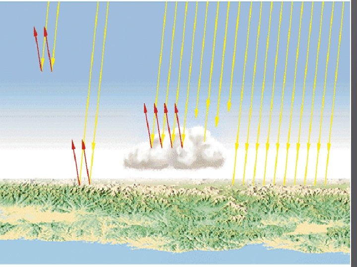
� � The Earth’s orbit is elliptical, so we are not always the same distance from the Sun. The Earth is actually closest to the Sun during our winter solstice, and farthest from the Sun during our summer solstice. The orientation (tilt) of the Earth causes the Sun’s rays to strike the surface at different angles. The angle of incidence affects the amount of energy transferred.
-Winter Solstice - shortest day of the year - N. Hem. is at its max tilt away from Sun - Sun’s rays are at it’s steepest angle Vernal Equinox -Summer Solstice - longest day of year -N. Hem is at it’s max tilt towards the Sun Autumnal Equinox
� Complete # 1 -3 on pg 509. � And # 1 and 2 on pg 519.
THE HYDROSPHERE
The hydrosphere consists of all the water (salt and fresh) on Earth. � ~ 70% of the Earth’s surface is water. � Only 2. 5 % of all water is fresh. � Of all the fresh water on Earth, over 87% is ice (glaciers and polar caps). � Over 12% of fresh water is under ground (i. e. groundwater). � Very little usable fresh water exists. (only 0. 4% of fresh water is on the surface or in the atmosphere) �
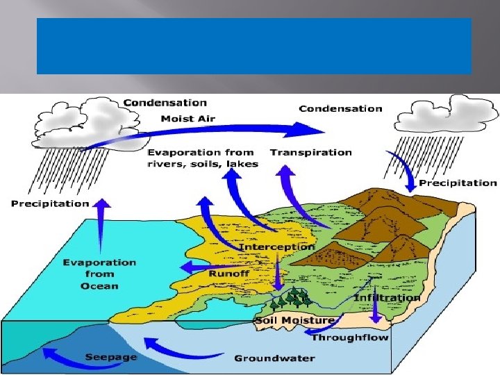
The Water Cycle Terms: � � � Evaporation: surface water (lakes, ponds, etc. ) changing to water vapor in the air. Sublimation: ice changing to water vapor. Transpiration: water leaving plants as water vapor into the air. Condensation: water vapor becoming liquid. Precipitation: water that falls to Earth as a liquid or solid.
Processes Involved in the Water Cycle: � � Radiant energy from the Sun causes surface water to evaporate, and ice to sublimate. Transpiration from plants adds to the water vapor in the air. Water vapor rises, cools, and condenses into clouds and fog. Precipitation (rain, snow, etc. ) falls from the clouds , and the process repeats.
� Draw a fully labeled illustration of the water cycle.
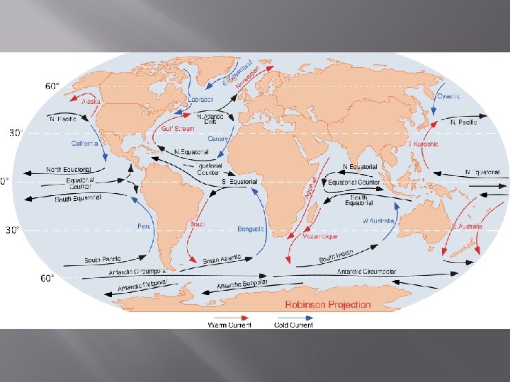
MAJOR OCEAN CURRENTS
� � Oceans have a huge affect on weather dynamics. They occupy a large portion of the Earth’s surface. Water’s high heat capacity will affect temperature and temp. changes in a given area. There is a vast amount of water at the equator where the sun is most direct. Ocean currents act as conveyor belts to transport energy around the world. See p. 525, Fig. 1. Note that the directions/flow of major ocean currents are similar to that of the prevailing winds.
Causes of Ocean Currents � � (i) Solar heating of the oceans near the equator results in convection currents. (ii) Continents redirect water to move along their edge. (iii) Earth’s rotation (eastward) has influence. Currents on the east side of oceans tend to be fast; west side currents are usually wider and slower. (iv) Salt content has an influence. Evaporation causes sea water to become saltier and sink – results in convection currents.
HEAT DISTIBUTION IN THE OCEANS
COMPLETE: “A Tale of Two Islands” Worksheet
Complete the following Questions: � Page 527, # 1, 2, 3, and 5. �
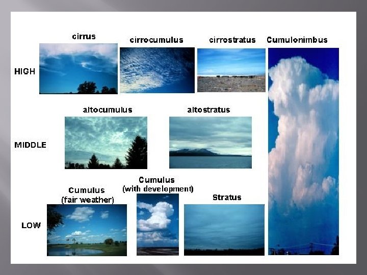
CLOUDS
� Clouds are formed when warm, moist air rises. It then cools at elevation and condenses into tiny water droplets (or ice particles) on dust particles. � There are 3 categories of clouds based on formation:
1. Convective Cloud Formation � � � Formed when a land mass is heated. Warmed air rises, cools, and condenses. Often develop where sea breezes occur.
2. Frontal Cloud Formation � � � Form at the frontal zone where two large air masses meet. The warmer mass is forced up over the cooler mass. As it rises, it cools and condenses into clouds.
3. Orographic Cloud Formation Formed when air is forced to rise up a mountain. � As it nears the top, it cools and condenses into clouds. �
Fog � � � Cloud type that forms near the ground. Forms when warm, moist air moves over a colder surface. (e. g. ocean) Cool surface causes the warm air to cool and condense at ground level.
CLASSIFICATION OF CLOUDS 2 Main Groups:
1. Cumulus � � Lumpy or “pillowy” clouds that result when strong upward motions exist in the atmosphere. Grow vertically. They indicate that the atmosphere is unstable, and are usually associated with stormy or severe weather. Can form by all 3 formation types.
2. Stratus � � � Wide , spread out, smooth, layered clouds. They indicate that the air motion is horizontal rather than vertical. Usually created from an air mass that is rising slowly. Usually indicates a stable atmosphere. Normally formed by frontal formation.
Additional Naming: If either class of clouds is NOT lowlying, include the prefixes: � alto – medium level � cirro – high level (cirrus – high, thin clouds) � May also contain the term “nimbus”, which means rain-bearing. �
� � Complete ALL questions (#1 -8) on “A Global Weather Model” – pg. 536 -7. Weather Test #1 – on all material covered up to this point. (Ch. 13)
Weather Forecasting � Meteorology : the study of the atmosphere and weather forecasting. � Studied by meteorologists.
Types of Weather Forecasting Technology
1. Weather Satellites Orbiting spacecraft that gather data and images, and relays them to weather stations on the ground. � Two types: �
(i) High-Orbit Satellites Orbit at around 36000 km above the equator. � Provide images that show cloud cover, physical features, etc. �
(ii) Low-Orbit Satellites At about 1000 km above the poles. � Gather data used to detect changes in air temp, assess water vapor at different levels and global wind patterns. �
2. Weather Balloons Helium-filled balloons launched 2 or more times per day at stations across N. America. � Carry instruments that collect data on temp, pressure, humidity, etc. � Also determine wind speed and direction. �
3. Ground-Based Technology � Instruments used at weather stations. Instrument Weather Factor Measured Thermometer Temperature Anemometer Wind speed and direction Aneroid barometer Atmospheric pressure Rain Gauge Rainfall Hydrometer or psychrometer Relative humidity
4. Computer Technology All collected data is gathered, stored, and analyzed by computer software. � Computers linked to satellite communication systems allows info to be sent around the world. �
Weather Systems � � A weather system is a set of temp, wind, pressure and moisture conditions for a region, that moves as a unit over a period of days. North American Systems: In the mid-latitudes of N. America, weather is difficult to forecast because it changes so often. Much easier to forecast near the equator (hot/humid) and near the poles (cool/dry).
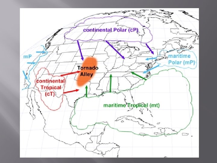
Air Masses The basis of weather systems in N. America. � They are large bodies of air in which temp and moisture content are fairly uniform. � Vary in size, from 100 – 1000 km across �
Major North American Air Masses Air Mass Temperature Moisture Content Where They Form Maritime Polar Cool Moist Over the North Pacific and Atlantic Oceans Continental Polar Cold Dry Over mid-polar regions of N. America Maritime Tropical Warm Moist Over the South Pacific and Atlantic Oceans Continental Tropical warm Dry Over mid-southern U. S. and northern Mexico
Maritime Polar Continental Polar Maritime Tropical Continental Tropical Maritime Tropical
Fronts A front is the leading edge of an air mass. � It is therefore also the boundary where different air masses meet. � There are 4 types of fronts: �
1. Cold Front - the leading edge of a cold air mass - When a mass of cold air pushes under a mass of warm air and pushes it upward, a cold front forms. - Active storms are sometimes associated with a cold front and followed by cool, fair weather.
2. Warm Front - Is the leading edge of a warm air mass. As it approaches the humidity will increase before it arrives. - It will be very high while its there, and will show a slight decrease after it leaves. Rain showers are associated with warm fronts.
3. Occluded Front - In most weather systems, the trailing cold fronts move more quickly than the leading warm fronts. Because cold fronts move more quickly, they often "catch" the warm front; an occluded front occurs. The warm is lifted above the Earth’s surface and is cut off (occluded) from the cooler air below. -
4. Stationary Fronts occur when two unlike air masses face one another, and there is little movement of air. - - On a weather map, a stationary front is drawn as a solid line with half-circles and triangles pointing in opposite directions. - The air on either side of a stationary front remains still for some time.
C B D A FRONTS
Depression ) Formation of a Low Pressure System (Depression (1) Front forms between cold and warm air masses (2) Jet stream pulls air up from both masses, leaves low pressure near ground (3) The low pressure attracts air near the surface (4) Rising air swirls (Coriolis) (5) Warm/moist air rises, condenses into cumulonimbus clouds (precipitation) (6) Occluded front forms (warm over cold) (7) Surface air stops drawing upward; precipitation slows, air pressure increases near the ground and the storm weakens.
� � � Cyclogenesis: the process of forming a cyclone Cyclone: a low pressure system that rotates counter-clockwise (in the N. Hemisphere) and usually brings cloudy, stormy weather. Anticyclone: a high pressure that rotates clockwise (in the N. Hemisphere) and brings clear skies.
Warm, high pressure systems: form at 30 o latitude , when air from equatorial convection currents moving north becomes “cooler” and descends. � Cold, high pressure systems: occur in central Canada and the Arctic, from cold, dry descending Arctic air. � Complete p. 549, # 1, 2, 3, 4 and 6. �
REGIONAL WEATHER
Regional air movement occurs in a small area and is caused by temperature differences between: � - day and night � - the air over land water � Usually created by warm air rising over cold and creating convection currents. �
Convection Currents � � occurs when air is heated air becomes less dense and rises on top rising air cools and falls, while the cool air below warms and rises a cycle is created known as a convection current
Thermals � � � Caused by the heating of the land by the sun. Mild winds in the morning. Moderate winds by mid-day. Winds die off in the evening. Birds use them to help them glide.
Sea Breezes Occur during the daytime. � The Sun warms the land faster than the water. � Air rises from the land is replaced by cooler air from above the water, creating a sea breeze. �
Land Breezes Occur during the evening/night. � The air above the land cools faster than the air above the water. � Warmer air above the water rises, and is replaced by the cooler air above the land creating a land breeze. � Complete an illustration of a sea and land breeze. �
Lake-Effect Snow � � When warm air masses move across a large body of water, they can absorb a lot of moisture. In winter, this air can cool rapidly when it hits land, and can quickly condense resulting in severe snow events.
Chinook Winds � � � Occur in Western Canada. Moist air proceeds up the west side of the Rockies. The air condenses quickly (moisture removed), which releases a lot of energy and warms the air. Warm, dry winds proceed down the east side of the Rockies, causing a drastic rise in temperature. Complete page 555, # 1 -3.
EXTREME WEATHER EVENTS