Scandinavia How much do we know about it

Scandinavia • How much do we know about it? Go to zzi. sh Type the code given by the teacher Click: join my class Enter your name and START!

The Vikings http: //grekamag. gr/wpcontent/uploads/2015/03/vikings_season 3_ca st. jpg

Who were they? • they came from a foreign land, they were not “civilized” in the local understanding of the word • In A. D. 793, an attack on the Lindisfarne monastery in northeastern England marked the beginning of the Viking Age • By the mid-ninth century, Ireland, Scotland England had become major targets for Viking settlement as well as raids • Viking armies remained active on the European continent throughout the ninth century (attacking areas in France, Spain, Italy) • In the ninth century, Scandinavians (mainly Norwegians) began to colonize Iceland. By the late 10 th century, some Vikings (including the famous Erik the Red) moved even further westward, to Greenland
 • Most of")
The Vikings • Seafaring warriors–known collectively as Vikings or Norsemen (“Northmen”) • Most of the Vikings whose activities are best known come from the areas now known as Denmark, Norway and Sweden, though there are mentions in historical records of Finnish, Estonian and Saami Vikings as well

Scandinavia • Scandinavia, the most northerly region in Europe, is made up of Ø Norway, Ø Sweden, Ø Denmark • Also included Ø Finland Ø Iceland Ø The Faroe islands

Population GDP: ’ 15/2005 -15 Level of internet access At risk of poverty Norway 5, 214, 000 1, 6 / 1, 3 97% 15% Sweden 9, 851, 000 4, 2 / 1, 8 94% 16% Denmark 5, 707, 000 1, 0 / 0, 3 94% 17, 7% Finland 5, 487, 000 0, 2 / 0, 4 92% 16, 8% Iceland 332, 000 4, 2 / 1, 8 13% Compared with Romania 19, 760, 000 3, 8 / 2, 7 72% 37, 4% Greece 10, 793, 000 -0, 2 / -2, 1 69% 35, 7% GDP per inhabitant in purchasing power: http: //ec. europa. eu/eurostat/web/cohesionpolicy-indicators/statistics-illustrated Electricity generated from renewable sources: http: //ec. europa. eu/eurostat/web/energy/statistics-illustrated Source: eurostat 2016

Unemployment Currency Area Norway 5% Norwegian krone 324, 220 km 2 Sweden 6, 8% Swedish krona 449, 964 km 2 Denmark 6, 2% Danish krone 43, 094 km 2 Finland 8, 7% Euro 337, 030 km 2 Iceland 2, 9% Icelandic króna 103, 000 km 2 EU: 8, 1% Romania 5, 4% Leu/Ron 229, 891 km 2 Greece 23% Euro 131. 957 km² B a s I c f a c t s

Sweden https: //www. world atlas. com/img/area map/da 0297 bf 249 f 6 a 609538 d 9 c 607 b 2 0 e 95. gif • Capital: Stockholm • dozens of rivers and an estimated 101, 000 lakes • Sweden's border with Norway is covered by the Scandinavian Mountains, or in Swedish, the Kolen (or Kjolen) Mountains.

Kjolen Mounts, Norway Stockholm http: //bit. ly/2 Rsx. QQB

Denmark • Capital: Copenhagen • highest natural point: Møllehøj, at 170. 86 m • lowest point: Lammefjorden, at 7 m below sea level. • average height above sea level is only 31 m • coastline is indented by many fjords Fjord: a long, narrow arm of the sea bordered by steep cliffs: usually formed by glacial erosion
 Limfjord:")
Denmark • • • Jutland peninsula over 440 named islands (Sjælland the largest) Limfjord: not a proper fjord in a geological sense drained by a dozen or so rivers longest river in Denmark is the Guden at 160 km (https: //www. mapsofworld. com/denmark/maps/denma rk-river-map. jpg) Peninsula: an area of land almost completely surrounded by water except for an isthmus connecting it with the mainland

Limfjord Copenhagen

The Little Mermaid: Copenhagen’s landmark

Norway • Capital: Oslo • the Bergen Peninsula • over 90% of Norway is occupied by mountains (The Galdhøpiggen is the highest point of Norway standing at about 2, 468 m) Fjords line much of the country’s coastline, where the Atlantic flows inland. The longest fjord, the Sognefjord, stretches for 127 miles and reaches a depth of more than 4, 290 feet. UNESCO has named as World Heritage sites two others, the Geirangerfjord and the Nærøyfjord, both in southern Norway. The fjords offer excellent fishing and views of glaciers, waterfalls and villages with wooden houses.

Geirangerfjord Nærøyfjord

Finland • Capital: Helsinki • innumerable islands, rivers and streams, as well as an estimated 188, 000 lakes (near 60, 000 of them measure more than 200 m wide. • 70% of it covered by thick forest

• To the north of the Arctic Circle, the terrain rises into the hills and low mountains of Lapland. (country's highest point, Haltiatunturi, at 1, 328 m, is on the border with Norway. • The Aland Islands (archipelago) sits in the middle of the Gulf of Bothnia between Finland Sweden. It contains almost 300 islands (80 inhabited), and over 6, 000 small (tiny) rocky islands.

Helsinki Archipelago National Park

Weather • Mild but varying depending on the region • Denmark, southern Sweden and west coast of Norway: marine west coast climate (west winds-winters not especially cold-mild summers) • Central part of Scandinavia (Oslo to Stockholm): more humid continental climate, gradually giving way to subarctic climate further north, (similar to the weather in Finland). • Parts of the Scandinavian mountains in Norway and Sweden: alpine tundra climate with very cold temperatures, especially in winter. • Further north, in the regions of Greenland Iceland: arctic climate with cold winters.

Fauna in Scandinavia moose

beaver wolverine otter Arctic fox

Scandinavia • The Land of the Midnight Sun In midsummer, the sun never sets, and there are 24 hours of daylight. During midwinter, the sun hardly rises and there are just a few hours of natural daylight. The darkness has an effect on some of the population, who suffer from seasonal affective disorder, or SAD.
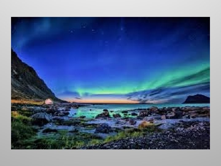

Scandinavia • Aurora When a solar storm comes toward us, some of the energy and small particles can travel down the magnetic field lines at the north and south poles into Earth’s atmosphere. There, the particles interact with gases in our atmosphere resulting in beautiful displays of light in the sky. Oxygen gives off green and red light. Nitrogen glows blue and purple.

Iceland • Capital: Reykjavik • Glaciers: cover 11. 5% of the total area of the country an arctic desert: mountains, glaciers, geysers, hot springs, volcanoes and waterfalls. March 21, 2010, the Eyjafjallajökull Volcano in southern Iceland erupted for the first time since 1821, forcing 600 people to flee their homes. Further eruptions in April forced hundreds of people to abandon their homes

Vatnajokull: largest glacier in Iceland

Eyjafjallajökull: volcano that erupted in 2010

Geysers in Iceland Geyser: a hot spring that intermittently sends up fountainlike jets of water and steam into the air

Hope you enjoyed the trip! And if you think you remember, let’s play! How about a map? Then go to https: //www. purposegames. com/game/o. R 4 x 7 m. DPr. Hj

References: • http: //www. history. com/topics/exploration/vikings-history • http: //ec. europa. eu/eurostat/data/browse-statistics-by-theme • http: //www. worldatlas. com/webimage/countrys/europe/lgcolor/secolor. htm • http: //www. worldatlas. com/webimage/countrys/europe/denmark/dkland. htm • http: //norwayvisit. weebly. com/major-landforms. html • http: //traveltips. usatoday. com/unique-geographical-features-landmarks-norway 104631. html • http: //www. worldatlas. com/webimage/countrys/europe/finland/filand. htm • https: //spaceplace. nasa. gov/aurora/en/ • http: //www. worldatlas. com/webimage/countrys/europe/iceland/island. htm • http: //www. dictionary. com

Images: http: //grekamag. gr/wp-content/uploads/2015/03/vikings_season 3_cast. jpg https: //upload. wikimedia. org/wikipedia/commons/1/12/Viking_Ship. jpg https: //upload. wikimedia. org/wikipedia/commons/9/9 f/Map_of_Scandinavia. png http: //www. worldatlas. com/img/areamap/da 0297 bf 249 f 6 a 609538 d 9 c 607 b 20 e 95. gif https: //live. staticflickr. com/5590/15138686641_b 43 a 6 d 29 cf_b. jpg http: //bit. ly/2 Rsx. QQB https: //live. staticflickr. com/3834/9568217715_cf 62626 b 5 b_b. jpg https: //p 2. piqsels. com/preview/543/688/8/adriatic-sea-channel-lim-turquoise. jpg https: //live. staticflickr. com/919/28435382407_1 fd 5 bb 96 f 3_b. jpg http: //bit. ly/2 qz. Aad. C https: //live. staticflickr. com/4088/4997436034_02811509 ee_b. jpg https: //cdn. pixabay. com/photo/2019/05/08/22/01/helsinki-cathedral-4189825_960_720. jpg http: //bit. ly/2 qr. NT 62 https: //commons. wikimedia. org/wiki/Alces_alces#/media/File: Male_Moose. jpg https: //storage. needpix. com/rsynced_images/spring-lake-4246520_1280. jpg https: //live. staticflickr. com/7183/6993254555_61844604 b 5_b. jpg https: //live. staticflickr. com/816/40931925062_806598 f 643_b. jpg http: //bit. ly/2 rou. Z 0 r https: //cdn. pixabay. com/photo/2019/06/21/10/51/midnight-sun-4289158_960_720. jpg https: //images. pexels. com/photos/3081835/pexels-photo-3081835. jpeg? cs=srgb&dl=aurora-borealis 3081835. jpg&fm=jpg https: //upload. wikimedia. org/wikipedia/commons/c/cf/Island_Vatnaj%C 3%B 6 kull_13. JPG http: //bit. ly/2 DWyb. Dm http: //bit. ly/38 i. Yyk. M
- Slides: 31