Satellite Remote Sensing of Particulate Matter Air Quality

 while utilizing")


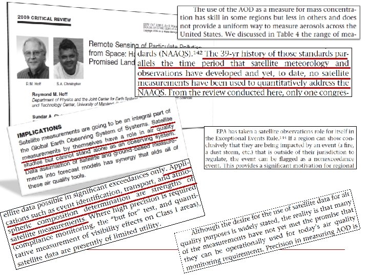
 -")


 underestimate high PM")


- Slides: 21
Satellite Remote Sensing of Particulate Matter Air Quality Pawan Gupta Originally presented at LADCO, March 12 -15, 2012 ARSET-AQ Applied Remote SEnsing Training A project of NASA Applied Sciences 1
OBJECTIVE Estimation of PM 2. 5 mass concentration at surface (µg m-3) while utilizing satellite derived Aerosol Optical Depth (AOD – unitless quantity) at a visible wavelength
What are we looking for ? Index Values Category Cautionary Statements PM 2. 5 (ug/m 3) PM 10 (ug/m 3) 0 -50 Good None 0 -15. 4 0 -54 51 -100 Moderate Unusually sensitive people should consider reducing prolonged or heavy exertion 15. 5 -40. 4 55 -154 101 -150 Unhealthy for Sensitive Groups Sensitive groups should reduce prolonged or heavy exertion 40. 5 -65. 4 155 -254 151 -200 Unhealthy Sensitive groups should avoid prolonged or heavy exertion; everyone else should reduce prolonged or heavy exertion 65. 5 -150. 4 255 -354 201 -300 Very Unhealthy Sensitive groups should avoid all physical activity outdoors; everyone else should avoid prolonged or heavy exertion 150. 5250. 4 355 -424
Satellite What Do Satellites Provides? Sun Column Satellite Measurement Seven MODIS bands 10 km are utilized to derive aerosol properties 0. 47, 0. 55, 0. 65, 0. 86, 1. 24, 1. 64, and 2. 13 µm 10 X 10 km 2 Ozone Rayleigh Scattering Water vapor + other gases (absorption) Particle size Composition Water uptake Vertical Distribution Aerosol Surface Satellite retrieval issues - inversion (e. g. aerosol model, background).
Measurement Techniques AOD – Column integrated value (top of the atmosphere to surface) - Optical measurement of aerosol loading – unitless. AOD is a function of shape, size, type and number concentration of aerosols PM 2. 5 – Mass per unit volume of aerosol particles less than 2. 5 µm in aerodynamic diameter at surface (measurement height) level
What satellites provide and how to get it?
MODIS-Terra True Color Images May 11, 2007 May 12, 2007 May 13, 2007 May 14, 2007 May 15, 2007 May 16, 2007 DRAFT
MODIS-Terra Aerosol Optical Thickness May 11, 2007 May 14, 2007 May 12, 2007 May 15, 2007 DRAFT May 13, 2007 May 16, 2007
AOT to PM
AOD to PM 2. 5 - Theoretical Hoff and Christopher, 2009
Two Variable Method 5 D + Multi. Variable Method 2 D + Artificial Neural Network MSC • 1 PM 2. 5 Estimation: Popular Methods Y=m. X + c AOT 1 D • + and Empirical Methods, Data Assimilation etc. are under utilized
AOT-PM Chu et al. , 2003 Wang et al. , 2003
AOT-PM 2. 5 Relationship Gupta, 2008
Limitation: Major Unsolved Issue All three Statistical models (TVM, MVM, ANN) underestimate high PM 2. 5 loadings
Vertical Distribution Engel-Cox et al. , Al-Saadi et 2006 al. , 2008
What Satellites can provide for vertical information? - CALIPSO Au g 1 7 Au g 1 8 Au g 1 9 Au Au Aug 2 Au 5 Aug 2 8 g 2 2 Au g 2 1 g 2 0 5 km 3 (courtesy of Dave Winker, P. I. CALIPSO)
Questions to Ask: Issues üHow accurate are these estimates ? üIs the PM 2. 5 -AOT relationship always linear? üHow does uncertainty in AOT retrievals affect estimation of air quality üDoes this relationship change in space and time? üDoes this relationship change with change in aerosol type? üHow does meteorology drive this relationship? üHow does vertical distribution of aerosols in the atmosphere affect these estimates?
Advantages of using reanalysis meteorology along with satellite TVM MVM
MODIS-Terra, July 1, 2007 Spatial Comparison n. Satellite-derived PM 2. 5 fills the gap in surface measurements TVM n. All three methods underestimate the higher PM 2. 5 concentrations. MVM Gupta et al. , 2010, to be submitted ANN
Combination of model and satellite observations van Donkelaar et al. , 2010