Satellite remote sensing in the classroom Tracking the
- Slides: 3

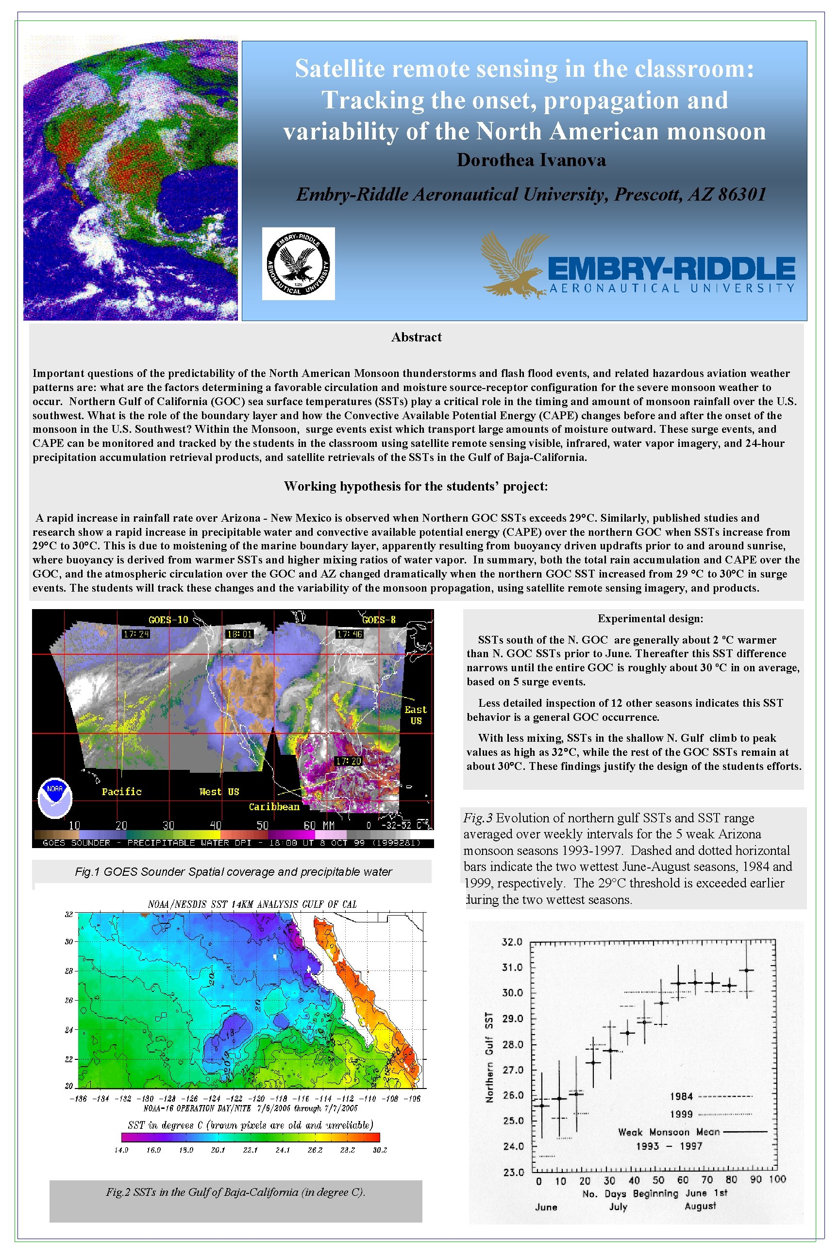
Satellite remote sensing in the classroom: Tracking the onset, propagation and variability of the North American monsoon Dorothea Ivanova Embry-Riddle Aeronautical University, Prescott, AZ 86301 Abstract Important questions of the predictability of the North American Monsoon thunderstorms and flash flood events, and related hazardous aviation weather patterns are: what are the factors determining a favorable circulation and moisture source-receptor configuration for the severe monsoon weather to occur. Northern Gulf of California (GOC) sea surface temperatures (SSTs) play a critical role in the timing and amount of monsoon rainfall over the U. S. southwest. What is the role of the boundary layer and how the Convective Available Potential Energy (CAPE) changes before and after the onset of the monsoon in the U. S. Southwest? Within the Monsoon, surge events exist which transport large amounts of moisture outward. These surge events, and CAPE can be monitored and tracked by the students in the classroom using satellite remote sensing visible, infrared, water vapor imagery, and 24 -hour precipitation accumulation retrieval products, and satellite retrievals of the SSTs in the Gulf of Baja-California. Working hypothesis for the students’ project: A rapid increase in rainfall rate over Arizona - New Mexico is observed when Northern GOC SSTs exceeds 29°C. Similarly, published studies and research show a rapid increase in precipitable water and convective available potential energy (CAPE) over the northern GOC when SSTs increase from 29°C to 30°C. This is due to moistening of the marine boundary layer, apparently resulting from buoyancy driven updrafts prior to and around sunrise, where buoyancy is derived from warmer SSTs and higher mixing ratios of water vapor. In summary, both the total rain accumulation and CAPE over the GOC, and the atmospheric circulation over the GOC and AZ changed dramatically when the northern GOC SST increased from 29 °C to 30°C in surge events. The students will track these changes and the variability of the monsoon propagation, using satellite remote sensing imagery, and products. Experimental design: SSTs south of the N. GOC are generally about 2 ºC warmer than N. GOC SSTs prior to June. Thereafter this SST difference narrows until the entire GOC is roughly about 30 ºC in on average, based on 5 surge events. Less detailed inspection of 12 other seasons indicates this SST behavior is a general GOC occurrence. With less mixing, SSTs in the shallow N. Gulf climb to peak values as high as 32 C, while the rest of the GOC SSTs remain at about 30 C. These findings justify the design of the students efforts. Fig. 1 GOES Sounder Spatial coverage and precipitable water Fig. 2 SSTs in the Gulf of Baja-California (in degree C). Fig. 3 Evolution of northern gulf SSTs and SST range averaged over weekly intervals for the 5 weak Arizona monsoon seasons 1993 -1997. Dashed and dotted horizontal bars indicate the two wettest June-August seasons, 1984 and 1999, respectively. The 29°C threshold is exceeded earlier during the two wettest seasons.

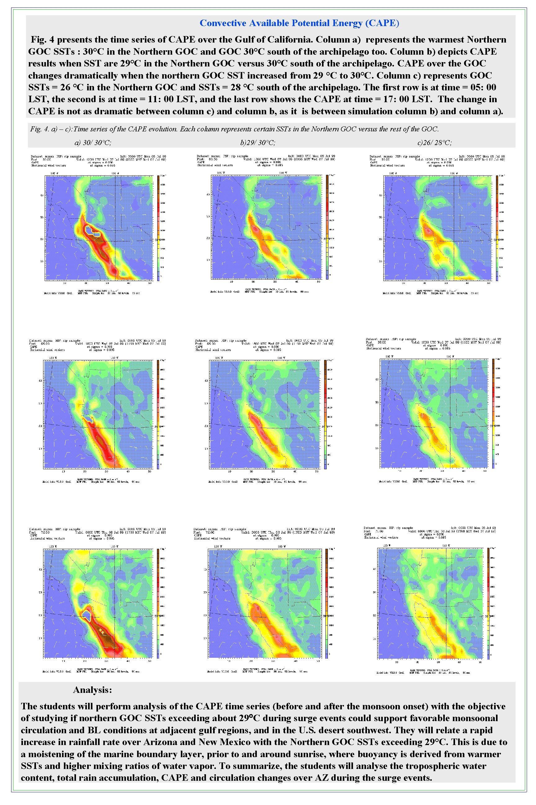
Convective Available Potential Energy (CAPE) Fig. 4 presents the time series of CAPE over the Gulf of California. Column a) represents the warmest Northern GOC SSTs : 30°C in the Northern GOC and GOC 30°C south of the archipelago too. Column b) depicts CAPE results when SST are 29°C in the Northern GOC versus 30°C south of the archipelago. CAPE over the GOC changes dramatically when the northern GOC SST increased from 29 °C to 30°C. Column c) represents GOC SSTs = 26 °C in the Northern GOC and SSTs = 28 °C south of the archipelago. The first row is at time = 05: 00 LST, the second is at time = 11: 00 LST, and the last row shows the CAPE at time = 17: 00 LST. The change in CAPE is not as dramatic between column c) and column b, as it is between simulation column b) and column a). Fig. 4. a) – c): Time series of the CAPE evolution. Each column represents certain SSTs in the Northern GOC versus the rest of the GOC. a) 30/ 30°C; b)29/ 30°C; c)26/ 28°C; Analysis: The students will perform analysis of the CAPE time series (before and after the monsoon onset) with the objective of studying if northern GOC SSTs exceeding about 29 C during surge events could support favorable monsoonal circulation and BL conditions at adjacent gulf regions, and in the U. S. desert southwest. They will relate a rapid increase in rainfall rate over Arizona and New Mexico with the Northern GOC SSTs exceeding 29°C. This is due to a moistening of the marine boundary layer, prior to and around sunrise, where buoyancy is derived from warmer SSTs and higher mixing ratios of water vapor. To summarize, the students will analyse the tropospheric water content, total rain accumulation, CAPE and circulation changes over AZ during the surge events.

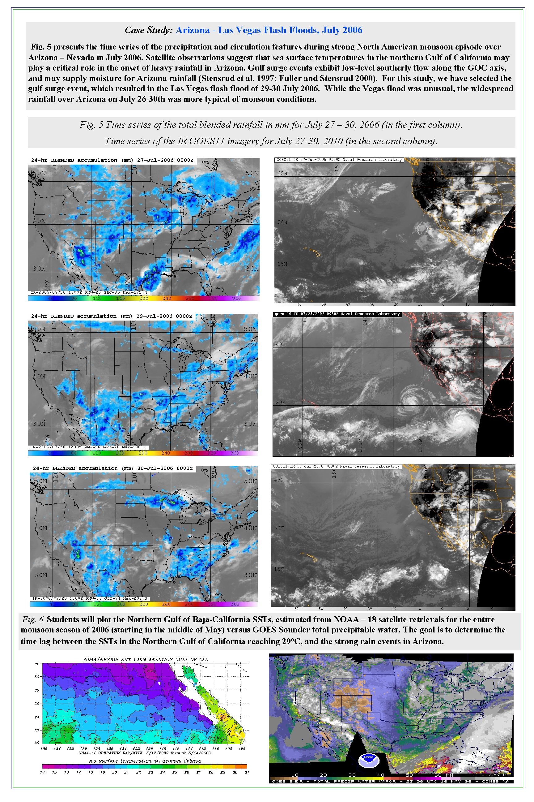
Case Study: Arizona - Las Vegas Flash Floods, July 2006 Fig. 5 presents the time series of the precipitation and circulation features during strong North American monsoon episode over Arizona – Nevada in July 2006. Satellite observations suggest that sea surface temperatures in the northern Gulf of California may play a critical role in the onset of heavy rainfall in Arizona. Gulf surge events exhibit low-level southerly flow along the GOC axis, and may supply moisture for Arizona rainfall (Stensrud et al. 1997; Fuller and Stensrud 2000). For this study, we have selected the gulf surge event, which resulted in the Las Vegas flash flood of 29 -30 July 2006. While the Vegas flood was unusual, the widespread rainfall over Arizona on July 26 -30 th was more typical of monsoon conditions. Fig. 5 Time series of the total blended rainfall in mm for July 27 – 30, 2006 (in the first column). Time series of the IR GOES 11 imagery for July 27 -30, 2010 (in the second column). Fig. 6 Students will plot the Northern Gulf of Baja-California SSTs, estimated from NOAA – 18 satellite retrievals for the entire monsoon season of 2006 (starting in the middle of May) versus GOES Sounder total precipitable water. The goal is to determine the time lag between the SSTs in the Northern Gulf of California reaching 29°C, and the strong rain events in Arizona.