Satellite Remote Sensing An Important Tool in Fisheries


 • 해양 광학 & 해색원격탐사실 한국 해양 연구원 http: //ocrl. kordi. re.")


- Slides: 26
Satellite Remote Sensing: An Important Tool in Fisheries Oceanography
Contents 1. Background 2. Fisheries applications of satellite remote sensing 3. Rationale for using satellite remote sensing data in fisheries oceanography 4. Satellite oceanography remote sensing cannot replace in situ measurements 5. Types of satellite data used in fisheries applications 6. Sources of satellite data • Examples of satellite remote sensing applications in fisheries research and management and protected species research 7. Potential for direct detection fish schools, fishing activities, and marine mammals using satellite remote sensing 8. Future needs of satellite remote sensing in fisheries oceanography
Contents • Sources of satellite data • Examples of satellite remote sensing applications in fisheries research and management and protected species research 1. Fish early life history and survival 2. Marine fish habitat and migration patterns 3. Stock assessment 4. Fisheries management 5. Protected species 6. Operational fishery oceanography in support of research cruises
Background • Satellite remote sensing – an extraordinarily effective and powerful tool • • • – fisheries oceanography research and fisheries management marine protected species research and management operational fisheries oceanography Significant stride, progress, and expansion a. increase in the availability and improvements in the access to satellite data b. the development of easy to use satellite data processing and display software packages combined with low cost computer hardware systems c. the increasing awareness of the successes in demonstrating the application of the technology to marine fisheries problems
Background • Satellite remote sensing – – – an extraordinarily effective and powerful tool Significant stride, progress, and expansion the use of satellite-derived ocean measurements to meet the operational fishery oceanography needs • • • tuna; salmon and albacore; lobster AVHRR; Sea. Wi. FS Fisheries applications of satellite remote sensing
Rationale for using satellite remote sensing data • Variations in marine environmental conditions affect the distribution, abundance and availability of marine fish populations: vulnerability and catchability of fish stocks a. To understand, model and predict the effects of ocean conditions on marine fish populations b. To efficiently harvest marine fish stocks, c. To effectively and rationally manage marine fisheries • ‘changing ocean’ and ‘average ocean’ – well-suited for measuring and monitoring the ‘changing ocean’ – large-scale synopticity, high spatial resolution, and frequent repeatability of
Rationale for using satellite remote sensing data • disadvantages – limited to the very near surface film of the ocean → representative of the those in the upper 100 -250 m – visual and infrared measurements are restricted to cloud-free areas → temporally averaged image; → new neural network methods → microwave and satellite sensors (altimetry, scatterometer, synthetic aperture radar, etc. ) not be replacements of in situ conventional measurements ships, data buoys, fixed and floating instrument arrays;
Types of satellite data used in fisheries applications • Infrared temperature and ocean color measurements – passive scanning radiometer systems measuring radiation in thermal and visible portion of the spectrum • • AVHRR; IR systems on NOAA polar-orbiting satellites CZCS the coastal zone color scanner; Nimbus-7 Sea. Wi. FS (Sea-viewing Wide Field-of-view Sensor); Sea. Star OCTS (Ocean Color and Temperature Sensor); ADEOS (Advanced Earth Observing Satellite) These data have been readily available a. After conversion to SST and chlorophyll or related optical data, the derived data measurements and products can be used directly in marine resource applications b. There is general understand confidence in the meaning of the satellite-derived data
Types of satellite data used in fisheries applications • Active microwave and radar satellite sensors – all weather – – ocean circulation patterns based on satellite altimetry SAR (Synthetic Aperture Radar) 합성개구 레이다 • • • – • • RADAR신호를 발생; 반사되어 돌아오는 신호 이용; 영상으로 복원하는 장치 기상조건에 거의 영향을 받지 않음; 구름이 많은 지역; 강우가 빈번한 지역 등 거리를 측정하는 기구인 레이다의 원리를 이용; 광학영상과는 다른 측면의 정보 가시광선대에서 얻을 수 없는 물체의 특성을 SAR영상에서 얻을 수 있음 detecting and monitoring fishing activities; fish schools; eddies, frontal structure, river plume scatterometer – wind structure ARGOS satellite location system GPS – fishing vessel monitoring systems (VMS); satellite networks; electronic ‘archival tags’
Sources of satellite data • • • real-time and near real-time AVHRR satellite data the NOAA Coast. Watch Program AVHRR HRPT (High Resolution Picture Transmission) Examples 1. 2. 3. 4. 5. 6. Fish early life history and survival Marine fish habitat and migration patterns Stock assessment Fisheries management Protected species Operational fishery oceanography in support of research cruises
Examples 1. Fish early life history and survival • combination of satellite-derived SST and surface chlorophyll distribution and advective transport of larval fishes, eggs. . TOPEX/POSEIDON satellite altimetry; geostrophic currents • • 2. Marine fish habitat and migration patterns 1. 2. 3. Stock assessment – environmental data 1. 2. 4. AVHRR and CZCS data eddy and fronts; SST fronts; chlorophyll direct application; standardization of CPUE or fishing effort variation built on an understanding of ocean processes and oceanic habitat Fisheries management
Examples 5. Protected species 1. AVHRR satellite imagery 1. 2. loggerhead turtles 1. 6. to reduce the impact of commercial trawl fishing on populations of threatened and endangered sea turtles to identify sea turtle habitat off the east coast of the USA satellite telemetry and satellite remotely sensed environmental data Operational fishery oceanography in support of research cruises 1. 2. 3. 4. AVHRR – guiding fisheries research vessel operations isotherm charts HRPT on APT (Automatic Picture Transmission) AVHRR satellite data NMFS; NOAA/NESDIS; GOES;
Potential • Direction detection of fish schools, fishing activities and marine mammals has not been possible – SAR signal modulation – convert radar images to pelagic fish school abundance of fishing effort estimates • the application of space-based radar systems for fisheries monitoring, control, and surveillance
Future needs • increased recruitment of trained scientists and technicians • sensors • the foraging habit of juvenile loggerhead turtles – – – ARGOS-derived turtle positions satellite-derived SST surface chlorophyll ocean currents archival tags
Commentary: Applications • The ocean is in a steady, rapid state of change • Currents cause constant changes in temperature and turbidity pattern • plankton blooms or red tides • mosaicking and interpolation approach – timeliness and synoptic • data cost • revisit frequency and region of coverage
References (web-info) • 해양 광학 & 해색원격탐사실 한국 해양 연구원 http: //ocrl. kordi. re. kr/ • 대한원격탐사학회 http: //www. ksrs. or. kr/ • 공공원격탐사센터 http: //krsc. kict. re. kr/ – 인공위성의종류와 특성 http: //krsc. kict. re. kr/CRA_RESEARCH/right_1_4. asp • REMOTE SENSING & GIS (김흥규) http: //myhome. shinbiro. com/~kimhk/ • The Basics of Satellite Oceanography http: //www. eeb. ucla. edu/test/faculty/nezlin/Satellite. Oceanogra phy 2009. html • Ocean Surface Topography http: //topexwww. jpl. nasa. gov/index. html
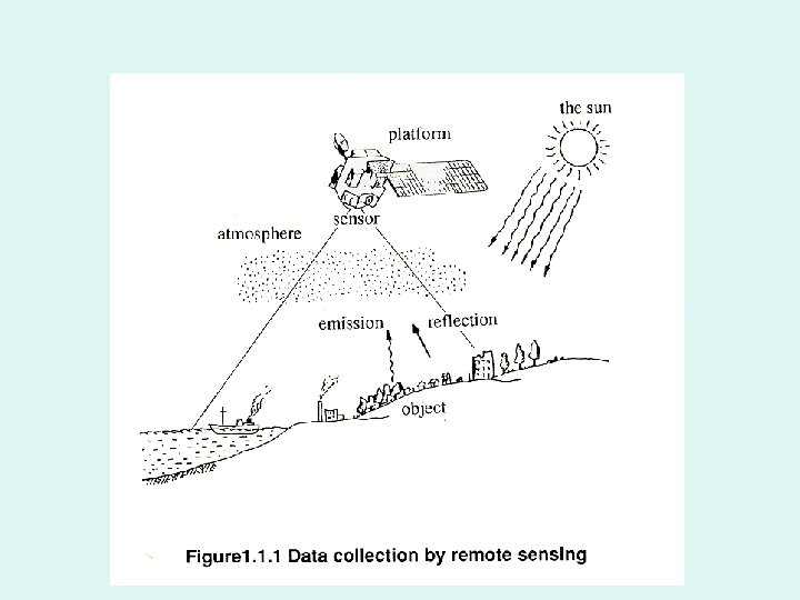
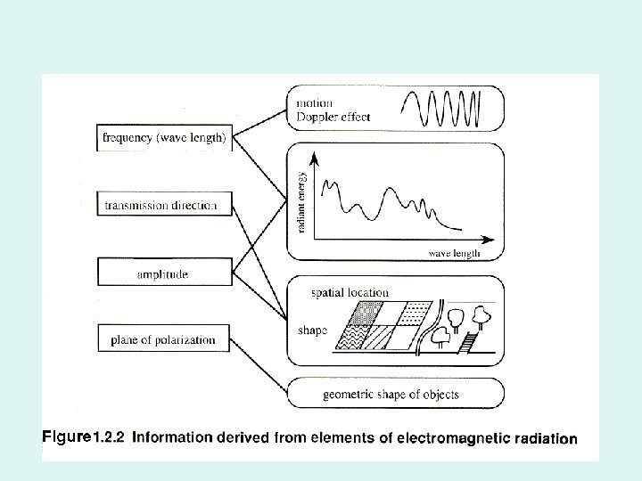
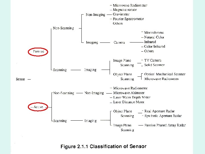
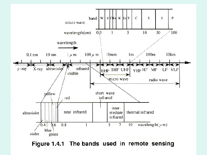
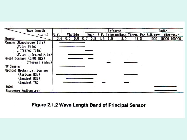
2. Sensors on satellites Passive sensors Wavelength Information Visible wavelength radiometers 400 nm - 1 m Solar radiation reflected by Earth surface Infrared (IR) radiometers about 10 m Thermal emission of the Earth Microwave radiometers 1. 5 - 300 mm Thermal emission of the Earth in the microwave Altimeters 3 - 30 GHz Earth surface topography Scatterometers 3 - 30 GHz Sea surface roughness Synthetic aperture radars 3 - 30 GHz Active devices Io. E 184 - The Basics of Satellite Oceanography. Sea surface roughness and 1. Satellites and movement Sensors
3. Satellite-to-Earth data transmission The information measured by sensors is - converted into digital format, - stored on magnetic media, and - transmitted to the ground receiving stations. HRPT (High Resolution Picture Transmission) format enables transmission of raw information to the receiving stations located on the Earth's surface. Each station includes receiving antenna and computer for processing and storage of information. HRPT format is used in IR sensors AVHRR (Advanced Very High Resolution Radiometer) and optical scanners (e. g. , Sea. Wi. FS). Io. E 184 - The Basics of Satellite Oceanography. 1. Satellites and Sensors
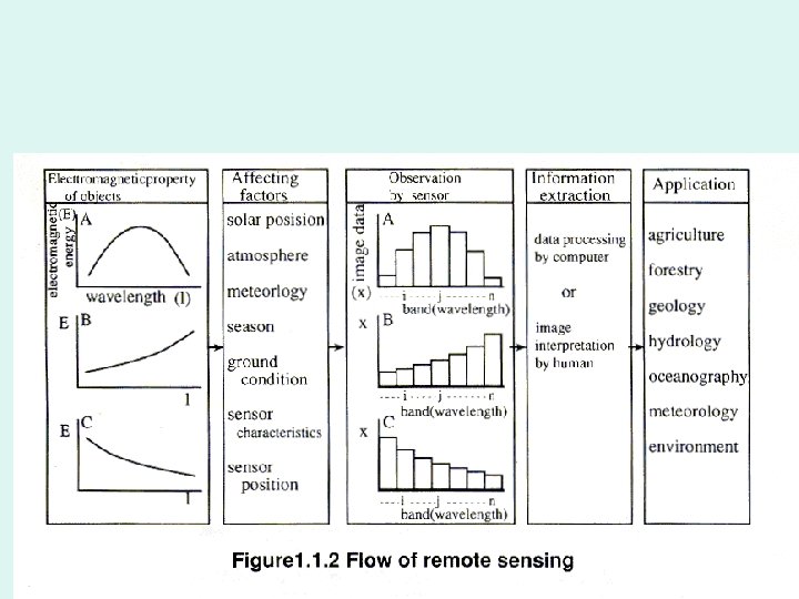
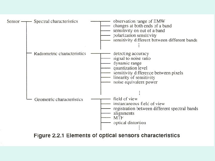
Remote sensing of the sea includes: 1. Sensor calibration 2. Atmospheric correction 3. Positional registration 4. Oceanographic sampling for "sea truth" 5. Image processing 6. Oceanographic applications of satellite remote sensing Io. E 184 - The Basics of Satellite Oceanography. 3. Remote Sensing of the Sea