Satellite Positioning Soviet Union Launches Sputnik October 4

Satellite Positioning Soviet Union Launches Sputnik October 4, 1957
 1964 -1973")
GLOBAL SATELLITE TRIANGULATION NETWORK (BC-4) 1964 -1973

ECHO 1 & 2/PAGEOS BALLOON SATELLITE TYPE PHOTOGRAPHED BY BC-4

BC-4 CAMERA PHOTOGRAPH PAGEOS SATELLITE AGAINST THE STAR BACKGROUND
 1959 First Successful Test")
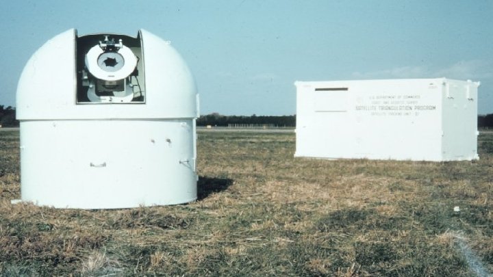
U. S. NAVY NAVSAT TRANSIT SATELLITE “Doppler” Prototype Launched (Failed) 1959 First Successful Test 1960 Operational 1964 (Military) Civilian Access 1967

Transit Geoceiver and VLBI Relative Positional accuracy ~ 2 -5 mm Relative Positional accuracy ~ 1 m

Global Positioning System GPS Block I § § § § GPS Block III February 22, 1978 - 1 st NAVSTAR Satellite launched July 17, 1995 - System Fully Operational May 1, 2000 - Selective Availability turned off September 26, 2005 - L 2 C band added May 28, 2010 - First L 5 Satellite added December 23, 2018 – First Block III launched 2023? - 10 -50 cm real-time accuracy -- NO GROUND CONTROL

Macrometer V-1000 GPS Receiver 1982 ~ appox. $250, 000 each
 – Coordinates derived from")
24 Horizontal Datums of the US Bessel Coordinates (1851– 1878) – Coordinates derived from locally defined astronomic observations – All computed on the Bessel 1841 Ellipsoid New England Datum (1879– 1900) – First to use Clarke 1866 ellipsoid, origin of coordinates station PRINCIPIO 1845 in Maryland U. S. Standard Datum (1900– 1913) North American Datum (1913– 1927) North American Datum 1927 (1927– 1986) Clarke 1866 ellipsoid Origin – MEADES RANCH 1891, Kansas Alaska Datums (14 Different 1890– 1954) Puerto Rico Datum (1901– 1986) Old Hawaiian Datum (1928– 1986) American Samoa Datum (1962 -1993) Guam Datum 1963 (1963– 1993) Clarke 1866 ellipsoid Origin – Local Astro station in each area North American Datum 1983 (1983–Present) – First to use GRS 80 ellipsoid, origin of coordinates at Earth Mass Center (Geocenter) 11

Positional Differences NAD 27 to NAD 83

Vertical Datums A set of fundamental elevations to which other elevations are referred. Datum Types Tidal – Defined by observation of tidal variations over some period of time (MSL, MLLW, MHW, MHHW etc. ) Geodetic – Either directly or loosely based on Mean Sea Level at one or more points at some epoch (NGVD 29, NAVD 88, IGLD 85 etc. )


National Water Level Observation Network http: //www. tidesandcurrents. noaa. gov Center for Operational Oceanographic Products and Services (CO-OPS) Water Level Sensors Plus: Wind Speed/Direction Barometric Pressure Air/Water Temp. Conductivity/Temp Tsunami/Storm Surge Data Transmission

Tidal Datums AL, AK, CA, CT, FL, GA, LA, MD, MS, NJ, NY, NC, OR, RI, SC, WA Privately Owned State Owned Uplands Tidelands Territorial Seas Contiguous Zone State Submerged Lands 3 n. mi. MHHW Federal Submerged Lands High Seas 12 n. mi. 200 n. mi. MHW MLLW Privately State Owned TX Exclusive Economic Zone Privately State Owned DE, MA, ME, NH, PA, VA Chart Datum
")
12 Vertical Datums of the US North American Vertical Datum 1988 (1991 – Present) National Geodetic Vertical Datum 1929 (1973 -1991) Sea Level Datum 1929 (1929 – 1973) Fourth General Adjustment (1912) Third General Adjustment (1907) Second General Adjustment (1903) First General Adjustment (1899) -- (A. K. A. Sandy Hook Datum) American Samoa Vertical Datum 2002 Puerto Rico Vertical Datum 2002 Northern Marianas Vertical Datum 2003 Guam Vertical Datum 2004 Virgin Island Vertical Datum 2009 17
 Original name: “ 1929 General Adjustment”")
NATIONAL GEODETIC VERTICAL DATUM OF 1929 (NGVD 29) Original name: “ 1929 General Adjustment” Later published as “Sea Level Datum of 1929” “Zero height” held fixed at 26 tide gauges Not all on the same tidal datum epoch (~ 19 yrs) Did not account for Local Mean Sea Level variations from the geoid Thus, not truly a “geoid based” datum Name changed to National Geodetic Vertical Datum of 1929 in 1973 by Federal Register Notice

The National Geodetic Vertical Datum of 1929 is referenced to 26 tide gauges in the US and Canada

The North American Vertical Datum of 1988 is referenced to a single tide gauge in Canada

Height Differences NGVD 29 and NAVD 88

NAVD 88 • Use of one fixed height removed local sea level variation problem of NGVD 29 • BM at Father Point (Pointe au Père), Rimouski, Quebec Selected because: a) It is also the origin of the International Great Lakes Datum of 1985 (IGLD 85) b) Height changes in the eastern U. S. would be minimized – this was important to USGS • The H=0 surface of NAVD 88 was supposed to be parallel to the geoid…(close again) 22

What You Can Not Do With GNSS-Derived Heights You can not currently achieve orthometric heights to national standards 1 st-, 2 nd-, or 3 rd-Order with GNSS observations

FEDERAL GEODETIC CONTROL SUBCOMMITTEE STANDARDS AND SPECIFICATIONS FOR GEODETIC CONTROL NETWORKS 1984 EXAMPLE 3 rd- Order Class 2 = 2 mm x √k For a 10 km / 6. 2 mi line = 2 mm x √ 10 = 2 mm x 3. 162 = 6. 3 mm / 0. 02 ft (95% confidence)
 84(G 1674) WGS redefinedwithrespectto")
WORLD GEODETIC SYSTEM 1984 DATUM = WGS 84 84(G 1150) 84(G 1674) WGS redefinedwithrespectto tothe WGS 84(G 1762) 84(G 730) --redefined RELEASED SEPTEMBER 1987 WGS 84(G 873) - redefined with respect to the 2000 2008 International Terrestrial Reference Frame THAN of 1992 BASED ON OBSERVATIONS AT MORE International Terrestrial Reference Frame of 1994 (ITRF 00) (ITRF 2008) (ITRF 92) 1900 DOPPLER STATIONS (ITRF 94) HOW MANY WGS 84 s HAVE THERE BEEN? ? GOOGLE “NGA_STND_0036” Table 2. 1, pg 2 -4

My Software Says I’m Working in WGS 84 Unless you’re doing autonomous point positioning you’re probably not in WGS 84 Project tied to WGS-84 control points obtained from the Defense Department -- Good Luck! Use ITRF/IGS coordinates and call them WGS 84 You’re really working in the same reference frame as your control points -- NAD 83?

If I think I really have WGS 84 Coordinates, what should I publish? Must know which realization WGS 84 (Transit) (1987 to June 28, 1994) WGS 84 (G 730) + Epoch of observation (June 29, 1994 to January 28, 1997) WGS 84 (G 873) + Epoch of observation (January 29, 1997 to January 19, 2002) WGS 84 (G 1150) + Epoch of observation (January 20, 2002 to February 7, 2012) WGS 84 (G 1674) + Epoch of observation (February 8, 2012 to October 15, 2013) WGS 84 (G 1762) + Epoch of observation (October 16, 2013 to Present) Which Geoid Model to use EGM 84, EGM 96, EGM 08 The epoch (decimal year) of the coordinates: January 20, 2020 = 2020. 066 (20/366 =. 055)

DATUM TRANSFORMATIONS 1. 2. 3. 4. 5. 6. WHAT DATUM ARE THE EXISTING COORDINATES ON? WHAT DATUM DO I WANT THE NEW COORDINATES ON? HOW LARGE AN AREA DO I WANT TO TRANSFORM AT ONE TIME? HOW MANY POINTS ARE COMMON TO BOTH DATUMS? WHAT IS THE DISTRIBUTION OF THE COMMON POINTS? HOW ACCURATE ARE MY EXISTING COORDINATES? 0. 05 ft. 4 ft 5 ft 7. HOW ACCURATE DO I WANT THE NEW COORDINATES?

Transform WGS 84 to NAD 27

DATUM TRANSFORMATIONS MOLODENSKY Converts latitude, longitude and ellipsoidal height to X, Y, Z Earth. Centered Coordinates. Applies a 3 -dimensional change in the origin (ΔX, ΔY, ΔZ) Applies a change in the size and shape of the reference ellipsoid Converts new X, Y, Z Earth-Centered Coordinates back to latitude, longitude and ellipsoidal height

Transform WGS 84 to NAD 27
 d. X")
Transform WGS 84 to NAD 83 ITRF 08 to NAD 83 (2011) d. X = 0. 99343 m d. Y = - 1. 90331 m d. Z = - 0. 52655 m r. X = 25. 91467 mas r. Y = 9. 42645 mas r. Z = 11. 59935 mas

Transform WGS 84/ITRF to NAD 83 HTDP http: //www. ngs. noaa. gov/TOOLS/Htdp. shtml

NADCON/NCAT DESIGNED TO SATISFY THE MAJORITY OF THE “IDEAL METHOD” DEFINED AS THE NATIONAL STANDARD. Federal Register Notice: Vol. 55, No. 155, August 10, 1990, pg. 32681 “Notice to Adopt Standard Method for Mathematical Horizontal Datum Transformation” DESIGN: v v v Provides consistent results, both forward and inverse Relies on over 150, 000 NGS archived stations existing in both NAD 27 and NAD 83 2 D transformation only – latitude/longitude Fast Not tied to NGS Data Base Accurate 15 cm in conterminous US: NAD 27 - NAD 83(1986) 5 cm per State/Region: NAD 83 (1986) – HPGN/HARN 1 -3 cm in conterminous US: HARN – NAD 83 (2007) & NAD 83 (2007) – NAD 83 (2010)

NADCON – Gridded Transformation Δλ = +0. 12344” Δθ = -1. 87842” Δλ = +0. 12249” Δθ = -1. 88963” Δλ = +0. 12399” Δθ = -1. 86547” Δλ = +0. 12354” Δθ = -1. 85943” Δλ = +0. 12423” Δθ = -1. 81246” Δλ = +0. 12568” Δθ = -1. 83364” Δλ = +0. 12449 Δθ = -1. 86905 Δλ = +0. 12431” Δθ = -1. 86296” Δλ = +0. 12441” Δθ = -1. 82879” Δλ = +0. 12499” Δθ = -1. 86543” Δλ = +0. 12640” Δθ = -1. 85407”

GOOD COORDINATION BEGINS WITH GOOD COORDINATES GEOGRAPHY WITHOUT GEODESY IS A FELONY
- Slides: 36