SAR Project Google Earth Assignment Missing w Male


- Slides: 27
SAR Project Google Earth Assignment
Missing! w Male boater w 15 foot one-man canoe w Blue/white color w Paddle propelled
Subject w 40 year old male w Experienced paddler but let’s face it - he’s seen better days. w Reported overdue on Friday, August 31 at 9 p. m.
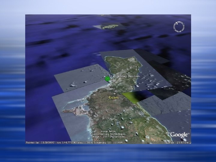
Last known position off Hospital Point - Friday 7 p. m.
Typhoon Fitow w Typhoon Fitow is approaching the Marianas waters. w Sea conditions are expected to become hazardous early Sunday morning, September 2.
Scramble! w Gather your team and devise a SAR plan to implement at first light. w You have an estimated 12 hours of search opportunity. w Consider all conditions for opportune success.
Assets w SAR Helo - HH-60 Jayhawk w USCG Coastal Patrol Boat - WPB 87 Marine Protector class.
SAR Conditions w Saturday, September 1 - 0700 w Seas increasing 3 -5 ft. w SAR area’s prevailing current is 1 knot to the north. w Wind blowing to the west at 5 knots. Expected to increase. w Overcast skies with intermittent showers.
SAR Search Area
Secondary SAR Area
SAR Terms w Datum - point, line, or area where object is expected to be located. The location probability decreases the further away from the datum. w Trackline - the path of the search vessel in a search pattern. Spacing of tracklines depends on conditions - most importantly visibility.
Spotting conditions Given the current SAR conditions…. w Assume search vessel speed to be limited to 10 knots. w Sea-level spotting is limited to 100 yards. w Helo spotting is limited to 0. 5 NM
SAR Search Patterns
Parallel track pattern
Parallel track pattern w Parallel track patterns are used when there is a probability that the search object could be anywhere in the search area. It is a good pattern to use when the approximate location of the search object is known and uniform coverage is desired. Parallel track patterns are the simplest of the search patterns. You steer straight courses on all legs. Each leg is one track spacing from the other. The legs are parallel to the long side or major axis of the search area.
Creeping line pattern
Creeping line pattern w The CS pattern is used when the probable location of the search object has been determined to be more likely at one end of the search area than at the other end. Creeping line search patterns are the same as parallel patterns, except that the legs are run parallel to the short side (minor axis) of the search area.
Sector pattern
Sector pattern w Sector search patterns are used when datum is established with a high degree of confidence, but the search object is difficult to detect, such as a person in the water. The search unit navigates through datum several times, each time increasing the chances of finding the search object. The pattern resembles the spokes of a wheel with the centre of the wheel at datum.
Square pattern
Square pattern w The square search pattern is used when the last known position of a search object has a high degree of accuracy, the search area is small, and a concentrated search is desirable.
Assignment w Devise a search plan that considers the present conditions. w Map two search patterns on Google Earth using the path tool: one for a helo search and one for a cutter. w Use different colors and a width of 4. 0 for your paths.
Assignment w Add placemarks marking the major turns of your search. Title each placemark with the estimated time in military format. (ie 0950) w If time permits, add spotting polygons to your search pattern. Use 50% opacity.
Assignment w Each team member needs to contribute to the effort. w Take turns adding paths, placemarks, or polygons. Save all in a SAR folder. w Be prepared to defend your SAR decisions. Keep a written record. w Problems may arise. Keep vigilant!
Good luck!
Credits w All images used are public domain. w Seach pattern diagrams and descriptions courtesy of the Canadian Coast Guard’s SAR Seamanship Reference Manual w http: //www. ccg-gcc. gc. ca/sar/nsm-msn/ichapter_11_e. htm