San Luis Obispo County Planning and Building Department

San Luis Obispo County Planning and Building Department GIS RURAL SUBDIVISION POTENTIAL ANALYSIS Jeff Legato Mapping and Graphics Specialist jlegato@co. slo. ca. us 805 -781 -5102

GIS Rural Subdivision Potential What? Why? How? -- Rural subdivision potential -- General Plan Update -- ESRI Model Builder

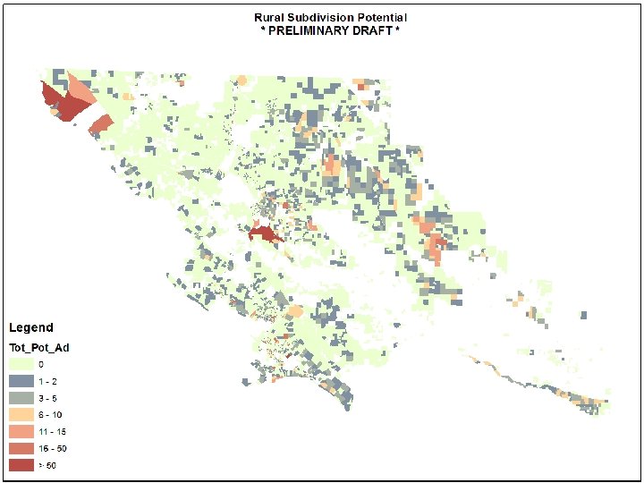
GIS Rural Subdivision Potential What is Rural Subdivision Potential?

Why subdivision potential? � County planning is updating the Land Use and Circulation Element of the General Plan www. slocounty. ca. gov/planning/LUCE_CAP. htm � Need understanding of: Potential housing units � Potential population � Water usage � Necessary land use acreage � Necessary park facilities � Police and fire requirements � Necessary school facilities � � etc

Build-out The possible amount of development allowed by the General Plan Traditional build-out analysis Add up all land use by type and divide by allowed density. Subtract out differing percentages for roads, vacancy rates etc. Not very realistic Relies on multiple gross general assumptions Doesn’t take into account existing lot sizes Can’t take into account multiple densities
 20 40 80 160 320 It all depends…")
Build-Out Multiple densities? Rural Land (RL) 20 40 80 160 320 It all depends… Rube Goldberg is the ® and © of Rube Goldberg, Inc. www. Rube. Goldberg. com
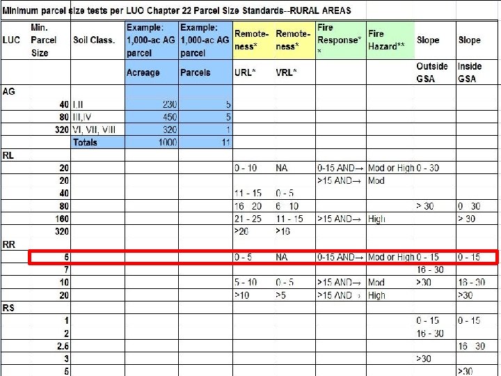

Build-Out Requires generation of data for inputs Separate models created for… Soil class acreage for each AG parcel by type Road miles to URL and VRL boundaries Fire hazard zones and response times Geologic Study Areas Average slope for each rural parcel

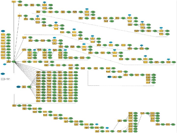
GIS to the Rescue! ESRI model builder Spatial Analyst Network Analyst

ESRI Model Builder Located in Arc. Catelog Click to bring Click to build up Arc. Toolbox new model

ESRI Model Builder Drag and drop processes and feature classes Connect the dots and run Click to connect processes

Recall Subdivision inputs Soil acreage by class for each AG parcel Average Slope for each parcel Remoteness in road-miles to URL and VRL Fire Hazard, Fire Response Time, and GSA
 Calculates crosstabulated areas between two")
Tools used Soil data Tabulate Area (Spatial Analyst Required) Calculates crosstabulated areas between two datasets and outputs a table. 14 planning areas Tip – Can’t add columns together if one of them has a null value
 Summarizes values of a")
Tools used Average Slope Zonal Statistics (SA Extension Req. ) Summarizes values of a raster (slope DTM) by zone (parcels)

Tools used Road Miles Network Analyst Extension Service Area polygons Needs points to route to How to create points from lines and polygons… Intersect roads with URL boundaries

Tools used Fire response/hazard and Geologic Study Area Select and calculate based on location
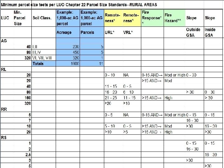

Tools used Select by attributes Simple matter of selecting parcels that meet the criteria and tagging them with the allowed density… ("avg_slope" > 30 AND ("GSA_FZ" IS NULL AND "GSA_LQLS" IS NULL)) OR ("avg_slope" <= 30 AND ("GSA_FZ" = 'GSA Seismic Hazard Area' OR "GSA_LQLS" = 'GSA Geologic Hazard Area')) OR ((( "VRL_RDMI" = '5 - 10' AND ( "URL_RDMI" = '20 - 25' OR "URL_RDMI" = '> 25')) OR ( "URL_RDMI" = '15 - 20' AND ( "VRL_RDMI" = '5 - 10' OR "VRL_RDMI" = '10 15' OR "VRL_RDMI" = '15 - 20' OR "VRL_RDMI" = '20 25' OR "VRL_RDMI" = '> 25' ))))
![Tip Subdivisions are whole numbers and are rounded down. 1 * INT ([ACRES] /](http://slidetodoc.com/presentation_image/2fc76f0cff9dc74be61aa3fab0a16048/image-20.jpg "Tip Subdivisions are whole numbers and are rounded down. 1 * INT ([ACRES] /")
Tip Subdivisions are whole numbers and are rounded down. 1 * INT ([ACRES] / 20) INT – Removes all decimal places leaving a whole number and rounds down.

San Luis Obispo County Planning and Building Department QUESTIONS ? Jeff Legato Mapping and Graphics Specialist jlegato@co. slo. ca. us 805 -781 -5102

GIS Constraints Analysis Groundwater Protected Resources Agricultural Other Public Safety Compilation
- Slides: 24