SAHARA AND SAHEL OBSERVATORY The Sahara and Sahel
 is a North-South solidarity")
SAHARA AND SAHEL OBSERVATORY The Sahara and Sahel Observatory (OSS) is a North-South solidarity partnership platform in the service of sustainable development in Africa

OSS Established in 1992, the OSS is an international organisation composed of 21 African countries, four European countries, four sub-regional African organisations, as well as United Nations specialised organisations, and NGO’s. The OSS has a rich heritage of experiences and actions laboriously acquired and achieved through scientific programmes in the service of circum-Saharan countries.

OSS action is focused on two major topics that are both strategic and of priority order for its members : 1 – Environmental monitoring, especially of desertification

2 - Water resources, in particular shared resources
 project intervenes in the framework of the programme")
The North-Western Sahara Aquifer System (NWSAS) project intervenes in the framework of the programme «Aquifer of the Major Sahel-Saharan Basins» initiated by OSS. The main objective of the Aquifers Programme is to promote the concept « basin awareness » , facilitating the implementation by the countries of appropriated strategies and tools for a sustainable management of shared water resources.

SAHEL-SAHARAN Great Basins Aquifers

NORTH WESTERN SAHARA AQUIFER SYSTEM SAHARA AND SAHEL OBSERVATORY

The North-Western Sahara Aquifer System or NWSAS refers to the overlapping of two deep aquifer layers: The formation of the Continental Intercalary, being the deeper one, and the formation of the Complexe Terminal, being slightly less in depth. This system overlies an area of onver one Million km 2, of which over 60% are in Algeria, a little less than 10% in Tunisia, and 30% in Libya.

Ground flows are manifested at surface level under the form of springs …

… and foggaras, which have been exploited for quite a long time, and which have given rise to the oases where the modes of living have remained long in perfect symbiosis with the Saharan eco-system. Timimoun Foggaras Collector Picture PNUD 1987

Photo: Ministry of Agriculture, Tunisia The modernisation of tapping systems has facilitated the multiplication of drilled wells, especially artesian
![Total Abstraction in the Saharan Aquifers [Billion of cubic metres/year] … and let to](http://slidetodoc.com/presentation_image/360413204b8037f69d4dd65af4b6c4d4/image-12.jpg "Total Abstraction in the Saharan Aquifers [Billion of cubic metres/year] … and let to")
Total Abstraction in the Saharan Aquifers [Billion of cubic metres/year] … and let to a high increase of exploitation …

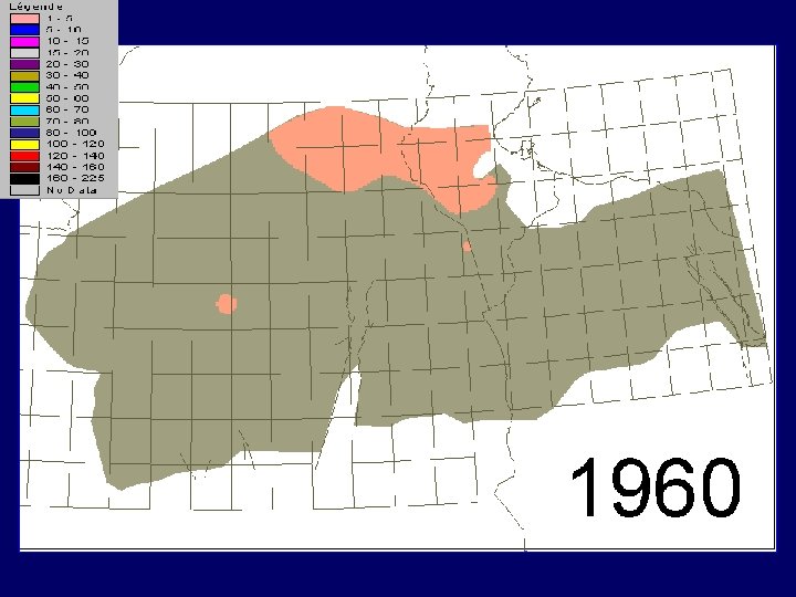
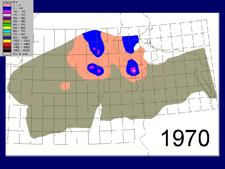
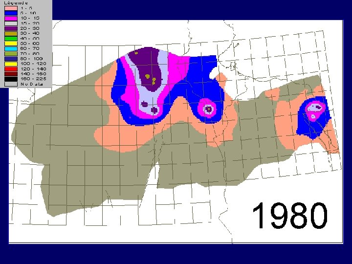
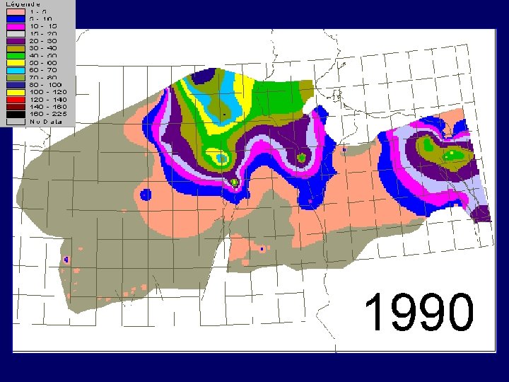
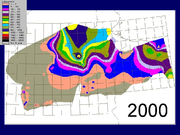
The increase in the number of drilled wells and of their exploitation flow reveals staggering rates for the past thirty years : from 0. 6 billion m 3/year in 1970, this exploitation now reaches: 2, 5 billion m 3/year

EXPLOITATION of NWSAS by DRILLED WELLS From 1960 to 2000

1960

1970

1980

1990

2000

NWSAS water points The Saharan Aquifer System is currently surveyed and exploited by about 9. 000 water points: drilled wells, springs and foggaras. These water points are distributed as follows: 6. 500 in Algeria, 1. 300 in Tunisia and 1. 200 in Libya.

TERMINAL COMPLEXE - MIZDAH INTERCALARY CONTINENTAL - KIKLAH The NWSAS constitutes a huge water reservoir containing Reserves whose volume is estimated as 30. 000 billion m 3. However, not all this water is usable.
![RAINFALL on NWSAS [mm/year] Being mostly of a desert character, this region receives very](http://slidetodoc.com/presentation_image/360413204b8037f69d4dd65af4b6c4d4/image-22.jpg "RAINFALL on NWSAS [mm/year] Being mostly of a desert character, this region receives very")
RAINFALL on NWSAS [mm/year] Being mostly of a desert character, this region receives very little rainfall, and the recharge of the aquifer system is only about one billion m 3 per year. It is a natural resource that is not quite renewable.

The issue addressed by the NWSAS is that of ensuring the best possible use of this water reservoir from a sustainability perspective, knowing that a certain number of problems are becoming more and more acute: 1. Due to pumping, the risk of increase in salinity is considerable; 2. The water level gradually decreases, and its cost is on the rise; 3. The natural outlets: springs and artesian wells, are drying up; 4. Interferences between the various water points of the basin are sometimes considerable.

INTERCALARY CONTINENTAL DRAWDOWNS 1950 2000

Legend meters

The leaders of the three countries are fully aware of these RISKS and have decided to undertake a major joint studies programme, while entrusting the OSS with the project management and with raising the funds necessary. In 1998, the OSS obtained assistance by the Swiss Cooperation, IFAD and FAO for a first three-year phase which started in July 1999. Other cooperation partners, subsequently joined the project.

The three components of NWSAS project HYDROGEOLOGY & INFORMATION SYSTEM MATHEMATICAL MODEL CONSULTATION MECANISM NWSAS objectives and activities are composed of three components : « Hydrogeology and information system » component, « mathematical model » component, and « consultation mechanism » component

DATA BASE ARCHITECTURE The development of the Information System has included a review of the current situation, the construction of the conceptual model, the establishment and the operating of a common data base. The scope of the task may be appreciated in view of the diversity and multiplicity of the operations carried out with regard to the 9. 000 water points inventioried : collection and homogenisation of the classification and identification systems, critical review, detection of erratic data, correction and validation.

Information System « SAGESSE » BD GIS Topographical map Water points layer hydrogeological layers Thematic layers Grid cells Factual Information Descriptive GIS data Time Series Socio-economic data Water points coordinates Water points relation Grid cells Digital data by grid cells Results by grid cell Numerical model The obtained Information system called « SAGESSE » allows the updating and addition of new data, statistical queries, graphs, DB – GIS – Model connections

Besides, the calculations made on the Model reveal that a mere continuation of the current abstractions, called « Scenario zero » would result in additional drawdowns in the two aquifers, in particular the Chotts basin. Such a situation would be unacceptable for the Complexe Terminal: any risk of percolation from the Chott to the aquifer would be fatal for the latter in terms of salinity. Here, it is necessary to envision a reduction of abstractions as a plausible scenario.

TERMINAL COMPLEXE ARTESIANISM TO CHOTTS 1950 2050 SCENARIO ZERO

legend Aquifer level inferior to Chott Aquifer level superior to Chott

Legend

legend

legend

legend

legend

legend

legend

legend

legend

legend

legend

IC Drawdowns , High Hypothesis Both the High Hypothesis and the Low Hypothesis would lead, in view of the obtained results, to unacceptable impacts on the future of the NWSAS

The simulations made based on the Model have highlighted the more vulnerable zones and allowed the establishment of the NWSAS RISKS MAP: In the Artesian basin, the expected additional drawdowns exceed 100 m; the flow of the Tunisian Outlet, which contributes in the recharge of the coastal aquifer of the Djeffara, must decrease; the Ghadames Basin in the IC presents drawdown risks.

The most exposed sector is the Chotts Basin. ² Along the Syrte coastline, the risk of marine intrusion would be seriously prejudicial to the Terminal Complexe and in Ferjan, major drawdowns are expected. There are possibilities of increasing the exploitation of the NWSAS, especially in the « new » and remote regions: Western Basin in the IC, Wadi Mya in the TC. However, there are still some uncertainties in this regard, which require further investigations.

NWSAS Risks Map Tunisian Outlet Chotts Syrte Artesian Basin Oued Mya Jufrah Ghadames Western Basin

Rome Workshop , December 20 th, 2002 What is the future outlook for NWSAS at the end of this investigation phase? The problems faced by the three NWSAS countries naturally induce to address these issues jointly: The practice of partnership conducted under the NWSAS project has built mutual confidence and trust, as well as the conviction that information sharing, which is the cornerstone for any solidarity, has become an activity that is not only possible, but also indispensable. Picture M. BESBES

Consultation Mechanism in its First Phase The three NWSAS countries decided to set up a permanent tripartite consultation mechanism for a joint management of the NWSAS. The Mechanism has assigned many missions that are focused on the production of monitoring indicators, the development of data bases and of models, the promoting of studies, research and training, as well as a consideration of the future of the mechanism itself.

NWSAS : ACTIVITIES of PHASE II MODELES REGIONAUX ASPECTS ENVIRONNEMENTAUX HUMID AREAS TC SUB MODEL BISKRA DJEFFARA PARTICULAR STUDY IC WESTERN BASIN NWSAS PHREATIC AQUIFER WATER QUALITY PROTECTION SALTED SOILS CHOTTS BASIN NWSAS SURVEY NETWORK NWSAS RECHARGE SAHARA WATER BANK NWSAS MODEL GHADAMES BASIN CONSULTATION MECHANISM PROCESS and OPTION of IRRIGATION VALIDATION of ABSTRACTION by USERS SOCIO ECONOMIC ASPECTS The implementation of the consultation mechanism has already started, in an experimental phase, within the OSS, as requested by the countries. The mechanism is sustained by a programme of in-depth studies and of sub-models. These studies take into consideration the socio-economic aspects and the environmental impacts; they should bring appropriate solutions to the problems and to multiple risks highlighted by the first phase of the SASS.

SYSTEME AQUIFERE SAHARA SEPTENTRIONAL OSS – May 2003 DU
- Slides: 57