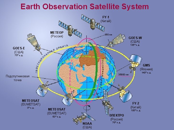
RUSSIAN HYDROMETEOROLOGICAL SATELLITE SYSTEM 850 METEOR 3 Oceanographical


 Resolution (km) MSU-MR")

 Siberia (Novosibirsk) Far-East (Khabarovsk)")
- Slides: 10
RUSSIAN HYDROMETEOROLOGICAL SATELLITE SYSTEM 850 км METEOR № 3 Oceanographical METEOR № 2 35600 км ELECTRO № 2 (14° E. ) ELECTRO № 1 (76° E. ) METEOR № 1
Russian Earth Observation Satellites Program 2006 -2015 Geostationary meteorological system 2006 2007 2008 2009 2010 2011 2012 2013 2014 2015 2016 2017 2018 2019 2020 ELECTRO № 1 (76°E) ELECTRO № 2 (location TBD) ELECTRO № 3 (76°E) R&D environmental satellites Polar-orbiting meteorological system METEOR № 1 METEOR № 2 METEOR № 3 (Oceanographical ) METEOR № 4 METEOR № 5 METEOR № 6 (Oceanographical ) KANOPUS-V № 1 KANOPUS-V № 2 RESURS-P № 1 RESURS-P № 2
ELECTRO-L General Design • Three-axis high-precision stabilization • In-orbit mass - 1500 kg • Payload mass - 370 kg • Lifetime - 10 years • Longitude - 76 E • Data dissemination format - HRIT/LRIT • Image repeat cycle – 30/15 min Mission objectives • Operational observation of the atmosphere and the Earth surface (MSU-GS) • Heliogeophysical measurements • Maintaining Data Collection System and COSPAS/SARSAT Service
MSU-GS Basic Performance Characteristics 1. Number of channels VIS IR 2. Spectral range at half maximum of spectral response function ( m) 10 3 7 0. 5 -0. 65; 0. 65 -0. 80; 0. 8 -0. 9; 3. 5 -4. 0; 5. 7 -7. 0; 7. 5 -8. 5; 8. 2 -9. 2; 9. 2 -10. 2; 10. 2 -11. 2; 11. 2 -12. 5 3. Image frame (deg x deg) 20 0. 5 x 20 0. 5 4. HRIT ground resolution in subsatellite point (km) 1. 0 (VIS); 4. 0 (IR) 5. S/N ratio for VIS channels 200 6. NE T at 300 K (K) in the band 3. 5 -4. 0 m in the band 5. 7 -7. 0 m in the band 7. 5 -12. 5 m 0. 8 0. 4 0. 1 -0. 2 7. Power (W) 150 8. Weight (kg) 88 9. Lifetime of basic and reserve units (years) 10
METEOR-M General Design • In-orbit mass – 2700 kg • Payload mass – 1200 kg • Lifetime – 5 years • Orbit – Sunsynchronous • Altitude – 830 km • Data dissemination format – HRPT/LRPT
METEOR-M Mission Objectives and Basic Instruments Application Spectral Band Swath-width (km) Resolution (km) MSU-MR Global and regional cloud cover mapping, SST, LST, … 0. 5 – 12. 5 m (6 channels) 3000 1 x 1 KMSS multichannel scanning unit Earth surface monitoring 0. 4 -0. 9 m (3 channels) 100 0. 06/0. 1 MTVZA imager/ sounder Atmospheric temperature and humidity profiles, sea surface wind 10. 6 -183. 3 GHz (26 channels) 2600 12 – 75 IRFS-2 advanced IR sounder * Atmospheric temperature and humidity profiles 5 -15 m 2000 35 Severjanin (SAR) Ice monitoring 9500 -9700 MHz 450 0. 4 x 0. 5 Radiomet* (radio occulation unit) Atmospheric temperature and pressure profiles. Instrument * - to be launched on board METEOR-M № 2
RESURS-DK General Design • In-orbit mass - 6570 kg • Payload mass - 1200 kg • Lifetime - 3 years • Orbit – elliptical, H=360 -604 km • Inclination – 70, 4° • Launched 15. 06. 2006 RESURS-DK Instruments Payload Swath Width - 28, 3 / 448 km Spectral Bands - 0, 58 -0, 8; 0, 45 -0, 5; 0, 55 -0, 59; 0, 65 -0, 68; 0, 72 -0, 75; 0, 75 -0, 78; 0, 78 -0, 9; 0, 9 -1, 1 m Resolution panchromatic system - 1 m multi spectral system - 2 -3 m
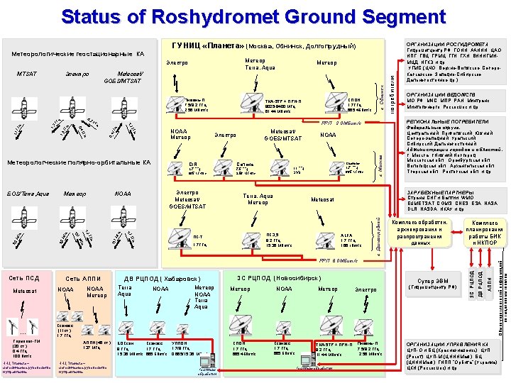
Roshydromet Satellite Ground Segment 3 Main centers: Europe (Moscow-Obninsk. Dolgoprudny) Siberia (Novosibirsk) Far-East (Khabarovsk) - 68 Local centers