RSGIS TECHNIQUES FOR REHABILITATION RECONSTRUCTION Disaster Rehabilitation Reconstruction

RS/GIS TECHNIQUES FOR REHABILITATION /RECONSTRUCTION

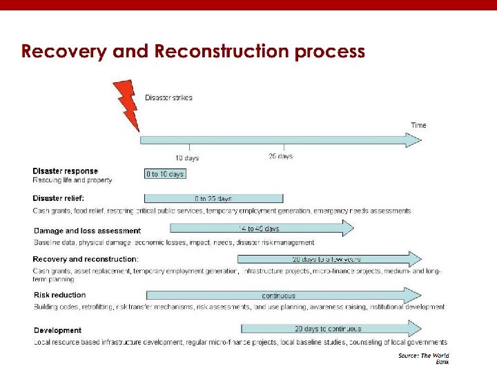
Disaster Rehabilitation/ Reconstruction • In common parlance, disaster rehabilitation involves methodical steps for bringing changes in the disaster affected site, with a view of ensuring long-term recovery. • Disaster rehabilitation may be considered a transitional phase between immediate relief and recovery. • It refers to actions taken in the aftermath of a disaster to enable basic services to resume functioning, assist victims’ self-help efforts to repair physical damages, revive economic activities; and provide support for the psychological and social well-being of the survivors. • Disaster rehabilitation/reconstruction involves both institutional arrangements and physical/structural repairing

Institutional Arrangements

INSTITUTIONAL ARRANGEMENTS - PRINCIPLES AND RECOMMENDATIONS Efficient Delivery Equity Put in place core institutional arrangement (nodal agencies) at federal and provincial levels– Clarity of roles in policy, coordination, M&E/reporting, fund flow/management and implementations Policy/strategy/criteria for equitable resource allocation among provinces/regions based on damages sustained and the associated disaster risks for reconstruction Transparency Pro-active program and strategic communications (disclosure) on Rehab and Reconstruction (RR), selection criteria, identification methodology, design standards, procurements, implementation and independent oversight and monitoring – public domain, Public Accounts Committee, civil society Accountability Enhanced fiduciary safeguards and risk mitigation capacities and measures – establish internal and external controls – country systems, special systems for RR projects building on what exists to meet donor requirement/harmonization – upfront challenge
, sectors and")
INSTITUTIONAL ARRANGEMENTS - PRINCIPLES AND RECOMMENDATIONS Coordination Effective coordination between agencies (donors), sectors and geographic areas, through sectoral, national, provincial and district level coordination fora Indiginizing best practices Fast-tracking procedures and systems for RR implementation – procurement, approvals and hiring of human resource and consultants – training to use existing and new fast tracking systems Subsidiarity Implementation responsibility, systems and capacities delegated to the lowest level of government – more ownership and accountability Socially responsive Timely and effective response to safeguards, grievances and complaints – to carry the additional RR load (individual and institutional

INSTITUTIONAL ARRANGEMENTS - PRINCIPLES AND RECOMMENDATIONS Planning and Budgeting Monitoring and Evaluation Realistic planning and budgeting – basic tools to fix responsibility for achieving results – weakest link Effective internal and external (third party) monitoring and evaluation of RR inputs, outputs, process and results – clearly defined roles at the federal and provincial levels and for outsourcing –built on and integrate with what we have

INSTITUTIONAL ARRANGEMENTS - PRINCIPLES AND RECOMMENDATIONS
")
Delineation & Monitoring the Rehabilitation of Breaches ( a case example)

Objectives • To Delineate breaches in flood protective infrastructure and observe the restoration process using satellite remote sensing technologies/GIS

Methodology • The methodology for delineation of breaches and mapping of embankments rehabilitation work consists of four phases: ü ü Satellite data and study area selection Pre-Floods Study: Identification of Breach Vulnerable Areas During-Flood Study: Delineation of Breaches Post-Flood Study: Validating the Breaches Rehabilitation Status

Methodology Flowchart

Satellite data and study area selection • The study area comprises Indus River flood plain affected by floods of 2010 ü Parameters considered for selecting satellite data; ü Satellite images, should not be elected of very next dates after the flood because it keeps on eroding due to the flash flow of water. ü It is necessary to compare pre-flood and post-flood images in order to ensure that the embankment is not already damaged. ü Selection of post-flood images in later dates after the decrease of water level
- Slides: 13