
ROYAL UNIVERSITY OF AGRICULTURE Faculty of Land Management

- Slides: 14
ROYAL UNIVERSITY OF AGRICULTURE Faculty of Land Management and Land Administration Topic: Assessment of Ambulance Response Times After Traffic Accidents by Using Network Analysis: Case Study Phnom Penh, Cambodia Team Members: Mr. Chea Chathav Ms. Keo Khenalen Mr. Mao Chhyfa Ms. Thea Chanthy Mr. Sorn Rithysak
Contents 1. Introduction 2. Methodology 3. Results 4. Discussion 5. References
Introduction 1. 8 million registered vehicles today. [7] 9. 6 million out of 15 million of the population is in between the driving age of 16 – 65 year olds. [7] Cambodia continues to experience rapid development and economic growth. [7] The estimated number of vehicles will reach 2. 6 million in 2018 and 3. 9 million in 2023. [7] With such rapidly growing numbers of vehicles, there is a risk of increasing number of fatal road accidents if the issue of emergency response is not addressed.
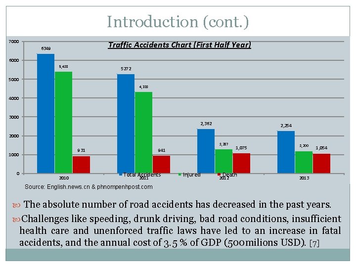
Introduction (cont. ) 7000 Traffic Accidents Chart (First Half Year) 6349 6000 5, 418 5272 5000 4, 331 4000 3000 2, 362 2, 254 2000 1, 287 1000 0 941 931 2010 Total Accidents 2011 Injured 1, 075 Death 2012 1, 200 1, 054 2013 Source: English. news. cn & phnompenhpost. com The absolute number of road accidents has decreased in the past years. Challenges like speeding, drunk driving, bad road conditions, insufficient health care and unenforced traffic laws have led to an increase in fatal accidents, and the annual cost of 3. 5 % of GDP (500 milions USD). [7]
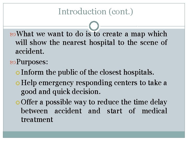
Introduction (cont. ) What we want to do is to create a map which will show the nearest hospital to the scene of accident. Purposes: Inform the public of the closest hospitals. Help emergency responding centers to take a good and quick decision. Offer a possible way to reduce the time delay between accident and start of medical treatment
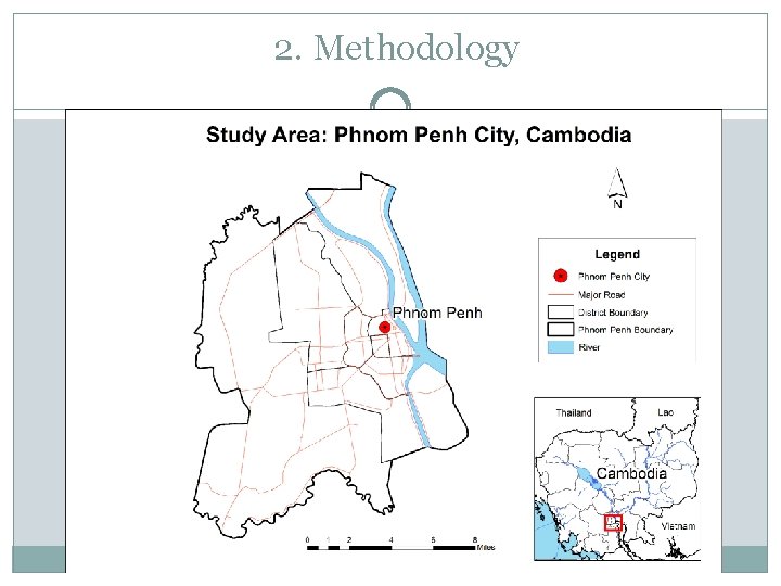
2. Methodology
2. Methodology (Cont. ) Data used: Road Dataset (Source: Openstreet. Map) Phnom Penh Hospitals (Source: OSM data, hand- held GPS) Only hospital which serve for ambulance service were added to analysis.
2. Methodology (Cont. ) v We will adopt the Network Analysis in Arc. GIS desktop to solve the problem. Step 1: o Assigning Topology rules for OSM road dataset Must Not Self-Overlap, Must Not Have Dangle o Fixing Topology errors in Arc. Map Step 2: o Fixing crossing errors (merge and split at intersections of road dataset)
2. Methodology (Cont. ) Step 3: Due to the time constraint, we did not mention some of road conditions such as One-way road, Turning, Restriction, etc. Although we assigned average Travel Speeds to road data according to road types as below: • 55 km/h for Primarily roads and Secondary roads • 50 km/h for Tertiary roads • 40 km/h for Residential roads Adding Travel Time to road data • ((([LENGHT] /1000) / [SPEED]) *60)
2. Methodology (Cont. ) • Step 4: • Creating Road Network Dataset Step 5: • Creating Hospital Service Areas using Travel Time (Minute) as impedance of the analysis setting, and break the value of 5, 10, 30 minutes.
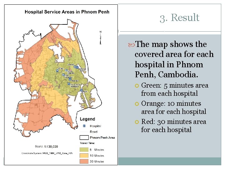
3. Result The map shows the covered area for each hospital in Phnom Penh, Cambodia. Green: 5 minutes area from each hospital Orange: 10 minutes area for each hospital Red: 30 minutes area for each hospital
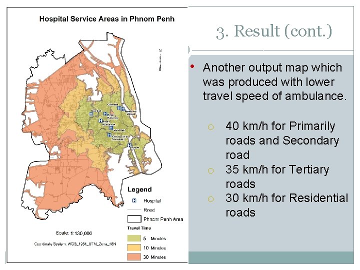
3. Result (cont. ) • Another output map which was produced with lower travel speed of ambulance. o 40 km/h for Primarily roads and Secondary road o 35 km/h for Tertiary roads o 30 km/h for Residential roads
4. Discussion Road data, We decided to use OSM data which is an open- source data. However, the quality and accuracy of data is still considerable. In the future, we hope to improve the results of this project by using more accurate travel times and data (e. g. road conditions, traffic density, one-way streets etc. ) It will take time and budget to cover more area in Cambodia.
5. References Chamreoun, S. (n. d. ). Define Optimal Path of Fire Response by Using GIS in Phnom Penh. Cambodia: Royal University of Agriculture. Tong, X. (2011, July 14). Road accidents claim over 940 lives in Cambodia in past 6 months. Retrieved July 24, 2013, from http: //news. xinhuanet. com/english 2010/world/2011 -07/14/c_13984385. html help. arcgis. com: Network Analyst. (2012, February 2). Retrieved July 24, 2013, from http: //help. arcgis. com/en/arcgisdesktop/10. 0/help// 004700000035000000 Openstreetmap. la: Cambodia road. (2013, July 1). Retrieved July 24, 2013, from http: //www. openstreetmap. la/downloads/cambodia/roads. shp. zip Kunthea, M. (2013, July 3). Road accidents drops in 2013. Retrieved July 24, 2013, from http: //www. phnompenhpost. com/national/roadaccidents-drop-2013 Wilson, K. (2013, May 20). Serious Efforts Are Needed to Tackle Cambodia ’s Traffic Issues. The Cambodia Daily. Retrieved from http: //www. cambod iadai ly. com