RIVER STUDIES The Changes downstream in a river


 - Corrosion Attrition Hydraulic Action - § is when the")


 F A E B")


- Slides: 67
RIVER STUDIES The Changes downstream in a river valley
The Hydrologic Cycle § Infiltration = Groundwater System § Runoff = Surface Water System
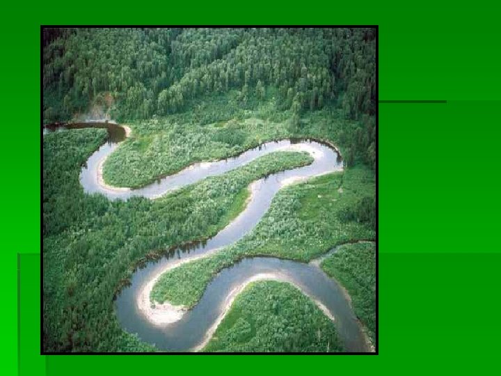
Satellite view of river drainage, Middle East What is this features?
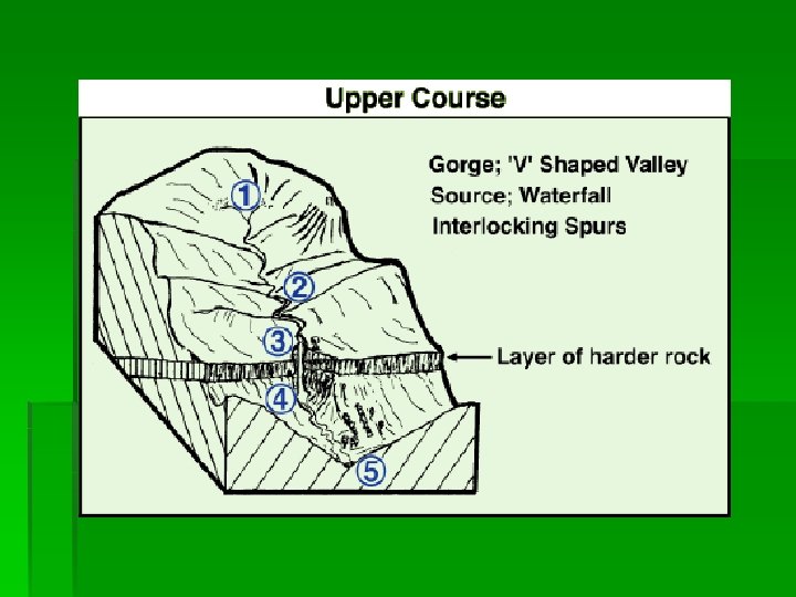
Upper valley characteristics
Upper valley characteristics
Upper valley characteristics “V”shape valley, vertical erosion dominant
Upper valley characteristics “V”shape valley, vertical erosion dominant Interlocking spurs
Upper valley characteristics “V”shape valley, vertical erosion dominant Interlocking spurs Slumping and landslides very active hill slopes
Upper valley characteristics “V”shape valley, vertical erosion dominant Interlocking spurs Slumping and landslides very active hill slopes Narrow, shallow channel, low velocity and discharge
Upper valley characteristics “V”shape valley, vertical erosion dominant Interlocking spurs Slumping and landslides very active hill slopes Narrow, shallow channel, low velocity and discharge Large bed load derived from upstream and from valley sides
Interlocking spurs, Robinson, Lake District A typical upper course valley with interlocking spurs, steep valley sides and active slope processes
River load in upper course Why are they rounded? Boulders are large and semi-rounded, due to attrition within the load and abrasion with the stream bed and banks
Rapids in the Upper Tees Valley WHAT IS A RAPID?
High Force waterfall, R. Tees WHAT IS A WATERFALL?
High Force waterfall, R. Tees Waterfall creates gorge as it recedes upstream by eroding the base and neck HOW IS A GORGE FORMED? What is this feature called? Plunge pool
Waterfall formation Look at the diagram, How is a waterfall formed?
High Force Waterfall R. Tees
Close-up of potholes How are these formed?
Potholes, human scale!!
Erosion Processes Abrasion (Corrasion) - Corrosion Attrition Hydraulic Action - § is when the river is loaded with material in suspension and scours away at the river banks. (Sandpaper effect) § is the shear force of the river impacting on the sides of the river banks. § is substances carried in solution such as acids. They dissolve rocks away over long periods of time. § is when bed load collides into each other with the current flow and breaks down into smaller particles.
Middle course, R. Tees HOW DOES THIS DIFFER FROM THE UPPER SECTION?
Middle course, R. Tees WHAT DO YOU THINK THE ARROWS POINT TO? Valley opens out, more gentle slopes, wider valley bottom First signs of meanders River channel wider, deeper, greater velocity and discharge
Meandering Rivers WHAT IS A MEANDER?
Formation of Meanders
Point bar deposits
Point Bar Deposits Point bar deposits grows laterally through time
Meander, R. Lavant, Chichester
Meander, R. Lavant, Chichester WHICH WAY IS THIS MEANDER MOVING? WHAT DO THE ARROWS POINT TO? Floodplain Slip-Off Slope Point bar deposits on the inner meander bend where there is low energy River Cliff
WHERE IS EROSION TAKING PLACE? Cut bank erosion (River Cliff) F A E B Point bar deposits C } Meander loop D WHERE IS DEPOSTION TAKING PLACE?
Meander on the R. Colorado WHY IS DEPOSITION OCCURING HERE?
How did these meanders form?
REVISION: What River features do you get here?
Migrating meanders, R. Gongola, Nigeria WHY ARE THEY MIGRATING?
What happens to the river when it moves to the middles course § Gradient becomes less steep § River continues to erode vertically but LATERAL erosion now occurs in MEANDERS § What is MEANDER MIGRATION ? § Name three effects it have on the valley? § What factors effect how much load is being carried?
Transportation § What are the four methods of transportation? § Traction - is when large particles roll along the river bed § Saltation - is when smaller particles bounce and collide in a leapfrog manner across the river bed. § Suspension - is when the river holds even smaller particles and carries them in its current. This is when the river appears to be murky. § Solution - is when dissolved material is carried.
Lower Course: Severn Valley
Lower Severn Valley Very wide floodplain Well developed meanders with bars in the channel indicating high Very gentle valley sediment load side gradients HOW DOES IT DIFFER FROM THE MIDDLE COURSE?
Flood Plains HOW DO YOU THINK THE TERRACES WERE FORMED? The entire floodplain can become covered with water during floods.
Ox Bow Lake Formation LOOK AT THE DIAGRAM & EXPLAIN THERE FORMATION
Formation of an Oxbow
Ox Bow lake on Mississippi
Levee formation
Levees WHAT DO YOU THING HUMANS MIGHT HAVE DONE TO THIS LEVEE?
Delta Formation WHAT IS A DELTA? DEPOSITON OF MATERIAL BY THE RIVER WHEN IT ENTERS THE SEA WHY DOES IT DROP ITS SEDIMENT
Mississippi Delta from Space MISSISSIPPI
The Nile Delta from space River Nile
Estuary Formation HOW DOES THIS DIFFER FROM A DELTA? RAISED VALLEY SIDES USING YOUR ATLAS FIND AN ESTUARY (LOOK AT THE RIVER THAMES) The Lower Course of a river valley has been DROWNED by a rise in sea level or a fall in the land level.
The Rhone Delta USING YOU ATLAS LOCATE THE RHONE DELTA
The Rhone Delta S. France Look at p 39 and identify the KEY FEATURES CAN YOU SEE IN THE SATELLITE PHOTO?
The Rhone Delta WHY HAS A DELTA FORMED HERE? LOOK AT P 39
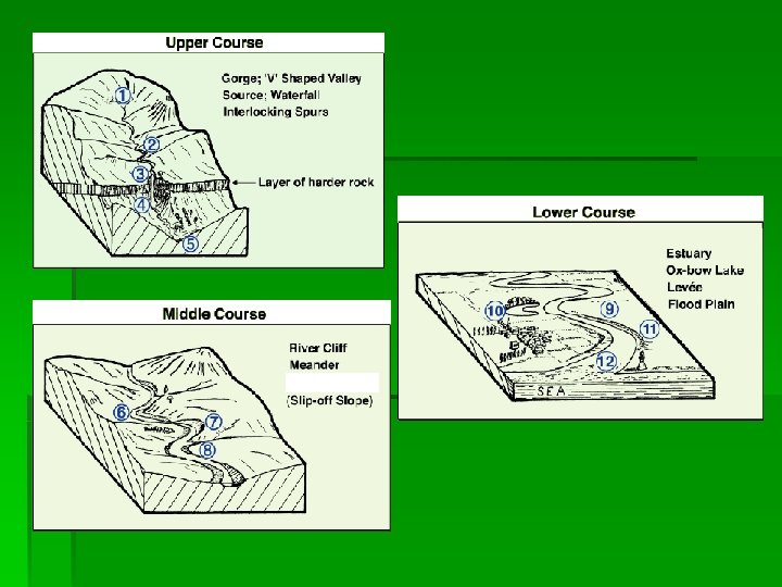
Summary of valley characteristics
The River Tees TRY AND FIND THE RIVER TEES IN YOUR ATLAS HINT LOOK AT THE MAP
Land Use in Drainage Basin of River Tees WHAT IS THE AREA IN EACH BOX?
Upper Tees COW GREEN RESERVOIR WHAT HUMAN INFLUENCES EXIST IN THE MAPS?
The Upper Tees Cronkley Scar WHAT ARE THE KEY GEOGRAPHCIAL FEATURES YOU CAN SEE IN THE PHOTOGRAPH MOORLAND STEEP VALLEY TURBULENT RIVER CHANNEL SLOPE DEBRIS WHAT LAND USES CAN YOU SEE IN THE PHOTO?
Upper Tees WHAT IS THE NAME OF THE WATERFALL?
The Lower Course Tees FLAT VALLEY FLOOR URBAN SETTLEMENT WIDE MEANDERS HOW HAS THE RIVER AND LAND USE CHANGED?
The Lower Tees TEESMOUTH ESTUARY WHAT LAND USE CAN YOU SEE IN THE PHOTOGRAPH?
The River meets the Sea
River Management WHAT IS THE FUNCTIONOF THE BARRAGE? LOOK AT P 42 WHAT DO YOU THINK THE PHOTOS SHOW?
Formation of the Mississippi River Delta More recent delta Modern sediments delta Early delta
Causes of Floods § A Flood can occur when a river exceeds its bank full stage and water will subsequently inundate the adjacent surrounding area. § Heavy rainfall - long periods of heavy rainfall will lead to an increase in surface runoff and increase in river level. § Snow melt and heavy rainfall - water in storage may be freed by Spring melts increasing surface runoff. § Deforestation - cutting down of trees leads to a reduction in interception rates and an increase in surface runoff. This may also lead to rapid erosion rates due to a lack of stability in the soil subsurface. § Urbanisation - tarmac and concrete surfaces are impermeable and lead to an increase in surface runoff.
Flood Control and Management § There a number of ways managing floods: § 1. Afforestation - planting trees increases interception rates and reduces surface runoff. § 2. Dams and Reservoirs - these hold back and regulate the flow of river water. Can be used as fresh water supply and generation of HEP. § 3. Diversion Channels - overflow channels which take surplus water out of a river in times of flood. § 4. Channel Straitening and Dredging - smoothens the channel to increase the speed (velocity) of the river and get water out of the drainage basin as quickly as possible. § 5. Artificial Levees - makes river banks higher therefore holding more water. § 6. Culverts - semi circular, smooth channels increase velocity and gets water away from urban areas as quickly as possible. § 7. Revetments and Channel Walls - strengthen river banks from erosion.