RIVER PROCESSES Introduction to Watershed Science Merritt College


- Slides: 47
RIVER PROCESSES Introduction to Watershed Science Merritt College Marc Epstein, Instructor
California River System
Major California Rivers and Topography
Drainage Basin Defined Every stream has a drainage basin. n A drainage basin is a spatial geomorphic unit occupied by a river system. n It is defined by ridges that form drainage divides; that is, the ridges are the dividing lines that control into which basin precipitation drain. n Drainage divides define a watershed. n
California Drainage Basins
Rivers and the Hydrologic Cycle Most rivers and streams begin as a result of precipitation n Precipitation will infiltrate into the ground water or flow on the surface n When sufficient water collects and flows in a uniform pattern, a stream is created n Most of California rivers begin from the melting of the snow pack n
Stream Flow n Stream Flow is potential energy converted to kinetic energy by gravity.
Measure of Stream Flow Q=wxdxv n Q = Discharge n w = channel width n d = channel depth n v = stream velocity n Expressed as cubic meters or cubic feet per second n
Calculating Discharge Compare the discharge of a stream whose measurements at a gauging station are: Width = 65 feet Average depth = 3 feet Velocity = 4. 2 feet/second
If the stream is the previous question passed through a more narrow channel of only 40 foot width, and we assume the same depth of 3 feet and the discharge remains constant, what will be the increased velocity?
If the stream in the preceding question achieves a deeper 4. 5 foot average depth at the site of the 40 foot width what will the new velocity be?
Suspension Streams transport material n Carrying capacity increases with velocity n Dissolved Load – Chemical solutions n Suspended Load – Fine grained clastic particles n Bed Load – Coarser materials dragged along the bed of the stream n
Velocity vs. Particle Size
Drainage Geometry
Characteristics Dendritic most common – From Greek word dendros meaning tree. n Small streams flow into larger ones. n Local geology will determine the geometry. n
Stream Evolution n Streams and rivers have an evolutionary pattern from initial formation to discharge into the ocean.
Stream Age
Initial Stream Development
Youthful Stream
Characteristics of Youthful Stream Steep gradient n Creates V shaped gorge or ravine n
Mature Stream
Characteristics of Mature Streams Reduced gradient n Sediment load = Load carrying capacity n
Old Age Stream
Characteristics of Old Age Stream Little gradient n Evidence of shifts in the river course is evident in the vicinity n
Stream Erosion n The erosional work of a stream carves and shapes the landscape through which it flows.
Types of Erosion Hydraulic Action – Is the work of turbulence in the water running. Water running causes hydraulic squeezing and release of action to loosen and lift rocks. n Abrasion – Is caused when debris move along, mechanically loosens and lifts rocks through grinding and carving of the streambed. n
Deposition n Whenever a streams velocity decreases, its ability to carry material is reduced. Consequently, some of the suspended particles begin to settle out.
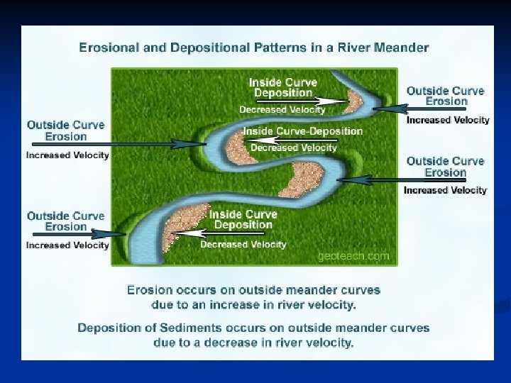
Meandering Stream n n n Where slopes are gradual, stream channels assume a snakelike form weaving across the landscape. The outer portion of each meandering curve is subject to greater velocity and erosive action and can be the site of steep bank called a cut bank. The inner portion of a meander is subject to less velocity and deposition forming a deposit called a point bar.
Meander Curve Formation
Floodplains
n Floodplains – The flat low lying area along a stream that is subjected to recurrent flooding. It is formed when the river overflows its channel during times of high flow. When floods occur, the floodplain is inundated. When the water recedes, deposits generally mask the underlying rock.
Floodplain Structure
Floodplain Terms
Floodplain Terms Defined n n n Natural Levee – On either bank of most streams, develop as a by-product of flooding. When flood water arrive, the river overflows it bank, loses velocity and spreads out, and drops a portion of its sediment load. Stream Terraces – Formation is a result of a stream cutting its floodplain to a lower elevation base level. River Delta – The mouth of a river is where it reaches its base level. The river’s forward velocity rapidly decelerates as it enters a larger body of water, resulting in deposition.
Examples of River Delta
Sacramento River Floodplain
Floods and River Management n Floods and floodplains are rated statistically for the expected intervals between floods. A ten year flood is expected to occur every 10 years, it has a 10% probability of occurring in any one year. A 50 or 100 year flood is of greater catastrophic consequence, but it is less likely to occur in any given year. These events will occur randomly over time.
Calculating Probabilities
Floodplain and Flood Maps
Human Impacts on Stream Processes Flood Control n Urbanization n
Flood Control Channelization – Process to straighten and deepen streams. n Reduce upstream flooding n Removes bank vegetation n Increases stream velocity n Increases stream flow n Promotes upstream erosion n Increases downstream flooding n Increases downstream depostion n Reduces habitat for aquatic wildlife n
Flood Control Building Levees or Floodwalls n Contain and accelerate stream flow n Increases water capacity to do damage downstream n Does not protect against unusually high and power floodwaters n
Natural Flood Control Preserve existing wetlands n Restore degraded wetlands n
Urbanization Covers land with buildings, asphalt, and concrete. n Greatly increases land area which is impervious to water. n Increases urban runoff during precipitation events. n Decreases groundwater recharge to local streams. n
Urbanization Mitigation Create green islands. n Storm drain retention basins. n
Climatic Change in California n n n Models indicate no change in precipitation amounts Precipitation to be more rain and less snow Reduced snow pack storage Increased frequency of flood events Less water available during the dry season