Review of the 2002 Grand Harbour Local Plan
 and the 2006 South Malta")
Review of the 2002 Grand Harbour Local Plan (Marsa) and the 2006 South Malta Local Plan (Luqa) as amended in 2011, and a Review of the 2006 Central Malta Local Plan for Qormi, as amended in 2013 and 2017; and of the provisions of PC 51/16 PRESENTATION TO THE PARLIAMENTARY STANDING COMMITTEE 10 TH JUNE 2020
 and the")
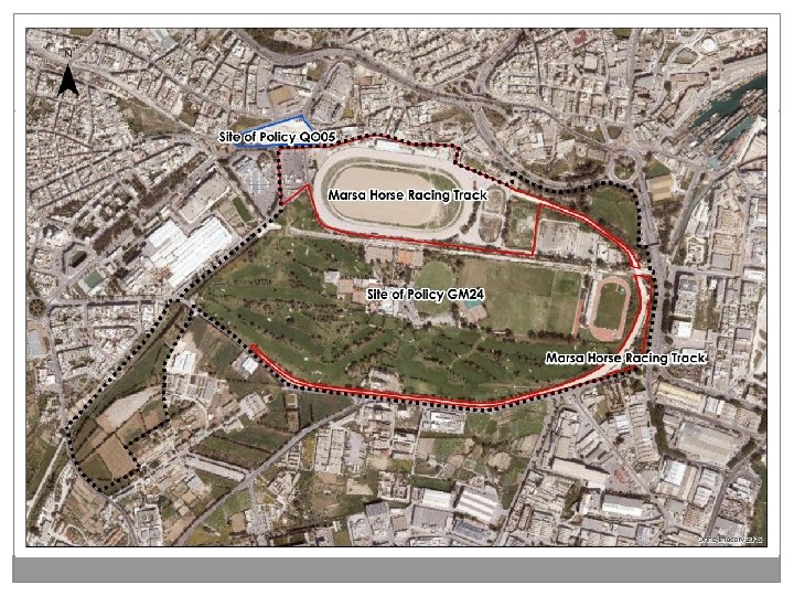
Objectives of the Review of the 2002 Grand Harbour Local Plan (Marsa) and the 2006 South Malta Local Plan (Luqa) as amended in 2011 Government is requesting the Authority to carry out a partial local plan review of the Grand Harbour Local Plan policy GM 24 with the following objectives: a) To remove the need for a development brief for the whole area; b) To designate a range of sub-zones within the area covered by policy GM 24 provided that the site indicated as the Marsa Horse Racing Track, shown in Figure 1 below, is designated as a unique and separate sub-zone for the development of the Horse Racing Track and supporting uses; c) To formulate a unique and separate development framework for the sub-zone of the Horse Racing Track and the other sub-zones; d) To carry out a re-apportionment of the total built footprint and the gross developable floorspace (GDF) established by policy GM 24 as approved in 2011 between the new sub-zones, provided that the built footprint of 60, 000 sqm and the GDF of 114, 000 sqm is not increased; e) To revise or delete any other provision of policy GM 24 which is deemed to prejudice the objectives set out under a) to d) above.

Objectives of the Review of the 2006 Central Malta Local Plan for Qormi, as amended in 2013 and 2017 The Central Malta Local Plan provisions for Qormi as detailed out in policy QO 05 and in PC 15/09 and PC 51/16 in relation to the site indicated in Figure 3 below need to be reviewed with the following objective: f) To amend the provisions of policy QO 05 and planning control applications 15 of 2009 and 51 of 2016 related to the maximum allowable height of buildings and delete the condition that the roof of the building below the level of Triq Hal Qormi (arterial road) should be allocated for soft landscaping to enable the increase of the allowable building heights to 11. 4 m above the upper road level.

PUBLIC CONSULTATION SUBMISSIONS

Summary of Representations on Objectives Rep. No. Author GHSM 001 Dr Edwin Mintoff GHSM 002 Environment and Resources Authority Late Submissions Kunsill Lokali Ħal Qormi Din l-Art Ħelwa

Dr Edwin Mintoff � Agrees with requirement for removal of Development Brief. � The footprint and GDF per sub- zone is however to be specified for each owner of any site within the area. � Request to zone site for retail, office and supporting leisure and catering uses over 10 floors. GHSM 001

Environment & Resources Authority � Any works for extension to the Golf Course proposed within the site of scientific importance are to be assessed in relation to adverse impacts on the geological significance of the site and the watercourse and its semi-natural banks are safeguarded. � No objection to the removal of the current development brief requirement (GM 24) as long as the whole area remains holistically planned through the individual sub-zones and their current frameworks. � The proposed re-apportionment of the total built footprint is to retain not only the limits on the built footprint of 60, 000 sqm and the Gross Development Floorspace of 114, 000 sqm but also the existing objectives in GM 24. � Objection to further intensification of the site of Policy QO 05 known as l-Istabal, due to the projected increase in noise pollution, air pollution and vehicular traffic. � Any new facilities are to be located underground; infrastructure is adequate and urban runoff is contained within the site without discharge into the watercourse. GHSM 002

SITE OF POLICY GM 24 POLICY BACKGROUND & SITE HISTORY
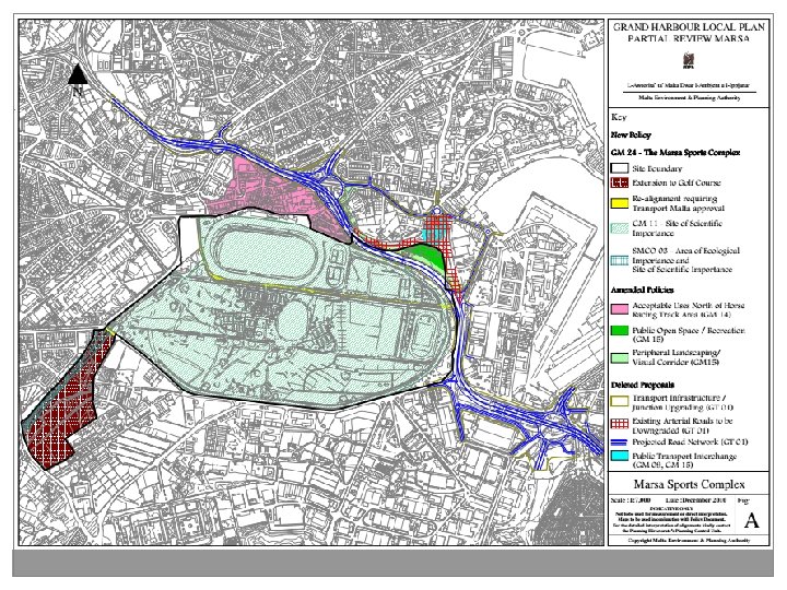

PROPOSED AMENDMENTS TO POLICY GM 24
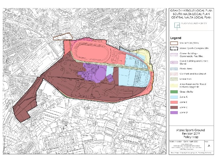

Apportionment of footprint and GDF Site Area – Total 704, 672 m 2 Zone A B C D Site Area/m 2 109, 587 179, 828 358, 609 56, 648 Total Built Footprint/m 2 32, 600 21, 000 2, 000 4, 400 Sports Uses/m 2 55% 50% Ancillary Uses/m 2 45% 30% 50% Not permitted 15% Not permitted 61, 600 43, 200 3, 500 5, 700 Sports Uses/m 2 65% 25% 60% 40% Ancillary Uses/m 2 35% 25% 40% 60% Not permitted 50% Not permitted Secondary Uses/m 2 Total GDF/m 2 Secondary Uses/m 2
")
Land Uses For the purpose of this policy, the gross developable floor area (GDF) is the total area which is internal and roofed over, including wall thickness (or in the case of party walls measured up to half the width of such walls) and also includes internal, completely enclosed, unroofed spaces. Service areas and parking areas are excluded from the GDF.

Land Uses � Ancillary uses to the primary/sports uses must operate in conjunction with the primary use, � Secondary uses can operate independently but take up a smaller proportion of footprint, � A variation not exceeding 5% in the allocated footprint and GDF within each zone may be considered provided that total footprint, GDF and the stipulated building heights within each zone are not exceeded and the urban design provisions in this policy are not compromised, � When applying the 5% variation policy, the Authority shall ensure that the GDF of the sports and ancillary uses combined shall remain higher than the GDF for the secondary uses.

Apportionment of footprint and GDF Site Area – Total 704, 672 m 2 Zone A B C D Site Area/m 2 109, 587 179, 828 358, 609 56, 648 Total Built Footprint/m 2 32, 600 21, 000 2, 000 4, 400 Sports Uses/m 2 55% 50% Ancillary Uses/m 2 45% 30% 50% Not permitted 15% Not permitted 61, 600 43, 200 3, 500 5, 700 Sports Uses/m 2 65% 25% 60% 40% Ancillary Uses/m 2 35% 25% 40% 60% Not permitted 50% Not permitted Secondary Uses/m 2 Total GDF/m 2 Secondary Uses/m 2

Zone A The land uses within this zone may include any of the following primary facilities: � Facilities for gymnastics, weightlifting, squash, athletics, football, handball, softball, rugby and both indoor and outdoor archery; � Indoor pool; and � High performance training centre with a multipurpose stadium. Ancillary Uses to the sports activities within this zone may include: � Spectator stands; � Class 3 A and 3 B tourism accommodation; � Class 4 A offices; � Article 4 B clubhouses; and � Class 4 C and 4 D food and drink outlets. Any buildings within this zone shall have an overall building height not exceeding 20 m above mean sea level, with the highest buildings within the zone being located at the periphery of the zone, in the vicinity of Triq Aldo Moro. Short distance and strategic views are to be respected and the visual amenity of the zone enhanced through the design of buildings of high architectural quality.


Apportionment of footprint and GDF Site Area – Total 704, 672 m 2 Zone A B C D Site Area/m 2 109, 587 179, 828 358, 609 56, 648 Total Built Footprint/m 2 32, 600 21, 000 2, 000 4, 400 Sports Uses/m 2 55% 50% Ancillary Uses/m 2 45% 30% 50% Not permitted 15% Not permitted 61, 600 43, 200 3, 500 5, 700 Sports Uses/m 2 65% 25% 60% 40% Ancillary Uses/m 2 35% 25% 40% 60% Not permitted 50% Not permitted Secondary Uses/m 2 Total GDF/m 2 Secondary Uses/m 2

Zone B The land uses within this zone may include the following primary facilities: � International standard facilities for horse racing (trotter and flat) and equestrian sports (polo, show jumping, dressage), training areas and stables Ancillary uses within this zone may include: � Grandstand; � Article 4 B clubhouses; � Class 3 C assembly and leisure; � Class 4 C and 4 D food and drink outlets; and � Betting shops. An area in Zone B shown in Map A as “Corner Building” is designated for commercial facilities to accommodate secondary uses, which shall only include: � Class 2 C (a) childcare facilities; � Class 4 A offices; and � Class 4 B retail outlets.

Zone B In addition, an area in Zone B as shown in Map A, � Constituting a footprint of 9, 000 m 2 over and above the allocated built footprint and GDF in Table 1 for this sub-zone, is designated as a multi-storey car park and bus depot. � The ground floor level is to retain a minimum of 3, 000 m 2 for the use as a bus depot. � The use of the roof level for photovoltaic panel installation is encouraged. � Vertical green wall screening across the facades, with the appropriate maintenance agreements in place is required.


Apportionment of footprint and GDF Site Area – Total 704, 672 m 2 Zone A B C D Site Area/m 2 109, 587 179, 828 358, 609 56, 648 Total Built Footprint/m 2 32, 600 21, 000 2, 000 4, 400 Sports Uses/m 2 55% 50% Ancillary Uses/m 2 45% 30% 50% Not permitted 15% Not permitted 61, 600 43, 200 3, 500 5, 700 Sports Uses/m 2 65% 25% 60% 40% Ancillary Uses/m 2 35% 25% 40% 60% Not permitted 50% Not permitted Secondary Uses/m 2 Total GDF/m 2 Secondary Uses/m 2

Zone C The land uses within this zone may include the following primary facilities: � Golf facilities; and � Golf academy. Ancillary uses to golfing activities within this zone may include: � Article 4 B clubhouses; � Class 4 A offices; and � Class 4 C and 4 D food and drink outlets. The provisions of South Malta Local Plan general policy SMCO 03 related to the Area of Ecological Importance and Site of Scientific Importance shall remain applicable.

Apportionment of footprint and GDF Site Area – Total 704, 672 m 2 Zone A B C D Site Area/m 2 109, 587 179, 828 358, 609 56, 648 Total Built Footprint/m 2 32, 600 21, 000 2, 000 4, 400 Sports Uses/m 2 55% 50% Ancillary Uses/m 2 45% 30% 50% Not permitted 15% Not permitted 61, 600 43, 200 3, 500 5, 700 Sports Uses/m 2 65% 25% 60% 40% Ancillary Uses/m 2 35% 25% 40% 60% Not permitted 50% Not permitted Secondary Uses/m 2 Total GDF/m 2 Secondary Uses/m 2

Zone D The land uses within Marsa Sports Club may include the following primary facilities: � Facilities for tennis, squash and cricket. Ancillary uses to the sports activities within this zone may include: � Article 4 B clubhouses; � Class 4 A offices; and � Class 4 C and 4 D food and drink outlets.

Other provisions Transportation � An area to the north-east as shown in Map A is to be reserved for road network upgrading as part of the project to improve traffic flow along Triq Aldo Moro. � Any proposal to severe the existing Ta’ Ceppuna link road or Marsa Road needs to ensure that third party access rights are safeguarded. � Lorry and horse trailer parking facilities are to be provided in Zone B as supporting facilities to the Marsa Horse Racing Track. � Where this policy intensifies any site within each zone, this is to be supported by studies which show the projected number of car parking spaces required and the measures taken to support the increase in demand. Urban Design � No built structure shall be higher than 20 m above mean sea level. A higher landmark building may only be favourably considered if the Planning Authority is convinced of its essential contribution to the overall design strategy, that it relates well to existing and planned taller buildings in the area and that it will enhance the image of the site and its surroundings.

Other provisions Environmental Sustainability � The scheme adopts environmental sustainability features such as: � conservation of energy and water, � renewable energy generation and reduction of waste, and � minimizes impacts on hydrology, ecology, biodiversity and cultural heritage. Planning Gain � A planning gain contribution of € 25/m 2 of commercial uses 4 A, 4 B, 4 C and 4 D as defined in the Use Classes Order, is to be made towards the Development Planning Fund solely for the development of the linear park and picnic area.

Other provisions Utilities � Any development is to ensure that the storm water channel is not negatively affected, but that it remains operational at all times. � Development on the south-westernmost part of the site must not prejudice the 200 m and 300 m groundwater safeguard buffer zone. Green Infrastructure � Existing ecological corridors and mature habitats are to be protected and restored. Being a bird sanctuary, any landscaping is to protect the habitat without inhibiting migratory patterns.

SITE OF POLICY QO 05 PC 51/16

Objectives of the Review of the 2006 Central Malta Local Plan for Qormi, as amended in 2013 and 2017 The Central Malta Local Plan provisions for Qormi as detailed out in policy QO 05 and in PC 15/09 and PC 51/16 in relation to the site indicated in Figure 3 below need to be reviewed with the following objective: f) To amend the provisions of policy QO 05 and planning control applications 15 of 2009 and 51 of 2016 related to the maximum allowable height of buildings and delete the condition that the roof of the building below the level of Triq Hal Qormi (arterial road) should be allocated for soft landscaping to enable the increase of the allowable building heights to 11. 4 m above the upper road level.

POLICY BACKGROUND & SITE HISTORY

PC 51 /16 on site of CMLP Policy QO 05

PROPOSED AMENDMENTS TO THE PROVISIONS OF PC 51/16

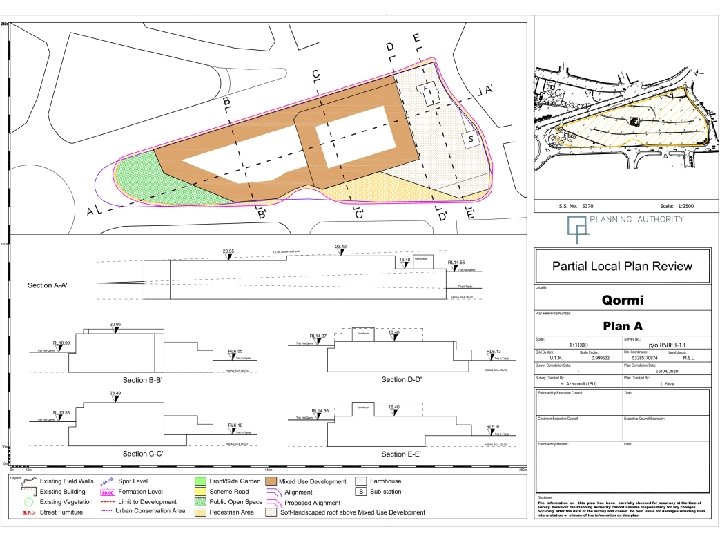
Amendments to PC 51/2016 – Site of QO 05 Conditions 1, 2, 3, 5, 9 and 10 of PC 51/2016 are superseded by the following conditions: A. The part of the site that is designated for development as indicated in Plan A the development of the following land uses will be considered: � Class 4 A, 4 B, 4 C, 4 D – Commercial � Class 3 C - Sports and Recreation Facilities � Car Parking Provision B. The designated public open space as identified in Plan A shall be made accessible to the public. Continuing protection and maintenance of such spaces will be secured by development control conditions. The public open space to be satisfactorily landscaped as per relevant guidelines. C. The developer shall at his own expense construct, implement and maintain the public open space indicated on Plan A. Alternatively, the developer may financially contribute Euro 210, 000 over and above any other rates established by LN 356/10 as amended by LN 163/16 for implementation of the public open spaces indicated on Plan A. These monies shall be administered by the Urban Improvement Fund and shall be allocated for the implementation of the public open space indicated on Plan A. D. A planning contribution of EUR 25/sqm of additional GDF shall be imposed and used to fund projects within the locality.

Amendments to PC 51/2016 – Site of QO 05 E. Development should not exceed a building height of 11. 4 m (inclusive of 1 m parapet wall) above the upper road level at Triq Hal Qormi as indicated in Plan A. The profile of development on site is not to extend beyond the development profile as indicated on section on Plan A. The section shall only be used for the interpretation of the building heights and setbacks. The section does not prejudice the road alignment. The form and treatment of the elevations of the development should provide both detailed and largescale visual interest and shall enhance the streetscape and the surrounding environment through high quality design. F. The built footprint for the levels above Triq Hal Qormi shall follow Plan A. The part of the site with no further development is to be soft-landscaped and shall pertain to the area around the reconstructed farmhouse, as shown in Plan A. This plan supersedes PC 51/16/48 B. G. No direct vehicular or pedestrian access on Triq Hal Qormi (arterial road) shall be permitted to the building; and adequate pedestrian access is to be permitted to the soft-landscaped area to be situated on the upper levels of the existing development. All other conditions in the PC are to remain unchanged.

2 nd Public Consultation During the meeting of the 5 th of May 2020, the Executive Council endorsed this review for a public consultation period of 6 weeks, from the 29 th May 2020 to the 10 th July 2020. Representations are to be made in writing to The Director of Planning, Planning Authority, 2020 Partial Review of the Marsa Sports Ground and PC 51/16 P. O. Box 200, Marsa GPO 01 or on the email ghlp@pa. org. mt.
- Slides: 39