Review 1 Briefly describe three stages of thunderstorm

Review

1) Briefly describe three stages of thunderstorm development. All updrafts Updrafts & Downdrafts All downdrafts
2) What is required for a thunderstorm to be considered severe? If it is severe, who releases warnings and/or surveys the damage for storm ratings? How are tornadoes rated? • Severe: 58 mph winds, 1 inch hail, tornado/funnel • NWS releases warnings, surveys damage • Tornadoes currently rated on the Enhanced Fujita scale, based on damage accounting for different construction types to estimate wind speeds
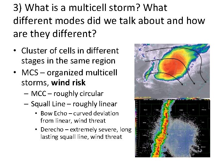
3) What is a multicell storm? What different modes did we talk about and how are they different? • Cluster of cells in different stages in the same region • MCS – organized multicell storms, wind risk – MCC – roughly circular – Squall Line – roughly linear • Bow Echo – curved deviation from linear, wind threat • Derecho – extremely severe, long lasting squall line, wind threat
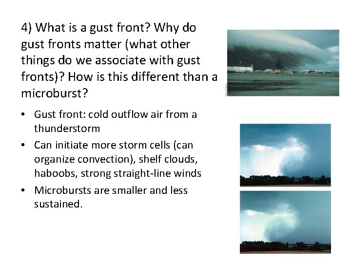
4) What is a gust front? Why do gust fronts matter (what other things do we associate with gust fronts)? How is this different than a microburst? • Gust front: cold outflow air from a thunderstorm • Can initiate more storm cells (can organize convection), shelf clouds, haboobs, strong straight-line winds • Microbursts are smaller and less sustained.
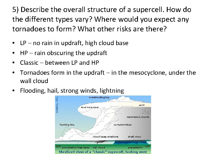
5) Describe the overall structure of a supercell. How do the different types vary? Where would you expect any tornadoes to form? What other risks are there? LP – no rain in updraft, high cloud base HP – rain obscuring the updraft Classic – between LP and HP Tornadoes form in the updraft – in the mesocyclone, under the wall cloud • Flooding, hail, strong winds, lightning • •
6) How can you tell the distance to a lightning flash? • Count the seconds between visible flash and thunder • Divide by 5 • Results in the miles to the flash
7) Briefly describe the stages of a tornado. What are most tornadoes rated? Which do the most damage? • • • Organizing – funnel and debris cloud Mature – peak intensity, often largest Rope/Dissipating – rope-like, lose of warm buoyant air Most tornadoes: EF 0 -EF 1 Most damage: EF 4 -EF 5
8) What scale is used to rate tornadoes? What are some of its limitations? • Enhanced-Fujita scale • EF scale measures the structure damage, NOT the wind speeds • Limitations: – – – Tornadoes don’t always hit structures Building codes vary Debris may damage structures too, not just the wind Surveyors are subjective Can’t verify the ratings with wind speed data, need mobile radars for this
9) Briefly describe the weather forecasting methods we discussed. • Persistence – tomorrow = today • Climatology – tomorrow = what average weather for tomorrow’s date is • Trend – whatever is upstream will be advected downstream (short term forecasts) • Analog – whatever most similarly happened in the past will happen again • NWP – computation of equations to determine forcings and resulting weather
10) What are the steps in running a weather model? What does each one give us? What are the main error sources? • Data assimilation – find the most likely state given observations and previous model • NWP – calculates the equations of state at each grid point • Post processing – creates images, statistics from the model output • Interpretation – the human factor, how well did the model do? • Error: physics, initial conditions
11) What are some of the steps/tools forecasters use in the weather analysis phase? What do these different tools reveal to a forecaster? • Observations • Weather maps (surface and aloft) • Reveal what is ‘actually’ going on, so they don’t rely just on models • How are the models currently different from reality? Says something about if the model is realistic or not
12) What are some of the ways we can investigate past climates? What are some of the larger natural impacts on climate? What about anthropogenic? • Tree rings, ice bubbles, carbon dating, sediment • Natural: Solar cycles, volcanic activity, current disruption, movement of plate and land surfaces • Anthropogenic: Urban heat island, land surface changes, emissions
Chapter 11 • Needed for intense thunderstorms: instability, lifting, wind shear • Most thunderstorms – weak single/multi-cell • Highest concentration of severe threats – supercells • Lifecycle – Cumulus – updrafts – Mature – both updrafts and downdrafts – Dissipating – downdrafts
• Severe requirements – 58 mph winds – 1 in hail – Tornado/funnel • Mesoscale Convective Systems – wind produces – Squall line – Mesoscale Convective Complex • Gust front – cool, outflow air – Shelf cloud, haboobs – Can aid in the production of new cells • Downburst – localized downdraft • Microburst – small, short-lived downdraft
Supercells • Most intense land-based convection • Characterized by mesocyclone (rotating updraft) and strong vertical wind shear • Abundant severe-weather producers • Overshooting top –clouds above the tropopause due to a strong updraft • Tropopause co-located with the anvil • Wall cloud – lowering in the updraft due to inflow into the storm, occurs in the “hook” of the storm
Supercells • Characterized by amount of precip around the updraft – High precipitation: obscured base, obscured tornadoes, scud clouds, hail – Low precipitation: rain-free base, typical of drier environments (dryline, upslope), low tornado threat – Classic: between Low and High precip supercells
• Floods – largest toll on life, more rain for longer time = more likelihood of flooding • Lightning – Charging in cloud from collisions of different precip particles, especially when ice is involved – Stepped leader – initial part of a flash – Return stroke – occurs if leader reaches the ground • Thunder – the shock wave from the pressure changes associated with the high temperature of the lightning • Distance to lightning (miles) = seconds between flash and thunder / 5 • Bolt from the Blue – lightning that strikes the ground from the side of the cloud, not the bottom • More IC’s than CG’s
Tornadoes • Violently rotating column of air in contact with the ground • Funnel – one that does not reach the ground • Most formed by supercells in a lowering of the wall cloud, short-lived, less than 1 mile wide • Tri-state Tornado – longest path recorded (MO, IL, IN) • El Reno – largest diameter recorded • Largest outbreak – SE in late April 2011 • Joplin, MO 2011 - costliest
Tornadoes • Stages – Organizing – funnel + debris cloud – Mature – peak intensity, typically largest size – Shrinking / Rope – lose warm inflow • Typically cannot be seen with the national radars – they show the mesocyclone not tornadic circulations due to their resolution • Tend to form in storms moving to the right of average motion
Tornadoes • Fujita scale – developed to rank tornados based on max damage observed – most tornadoes rated as weak (F 0 -F 1) – Most deaths in violent tornadoes (F 4 -F 5) • Enhanced-Fujita scale (2007) – takes different types of structures into account before ranking the damage • Tornado Alley – region in the Southern Plains were the highest concentration of tornadoes occur on average
Tornadoes • Dixie Alley – region with the most tornado deaths on average – Harder to spot – typically in HP supercells, hills and trees – Happen more often overnight than in other locations – Fast moving – High population density as compared to the plains – Large number of manufactured homes
• Tornado structure – low pressure at center, strong inflow at surface, upward motion in vortex, can have multiple vortexes around the periphery • Highest threat – flying debris • Watch – favorable conditions for given weather (hours before) • Warning – given weather indicated or observed, immediate action • Safest place – indoors, underground, away from walls/windows • Landspout – non-supercell tornado, usually short-lived, rapidly formed • Waterspout – non-supercell rotation over water
Chapter 13 • Persistence forecast – uses repeat of today’s weather • Climatology forecast – uses average weather for a given day of the year • Trend forecast – uses direct advection of upstream weather • Analog forecast – uses historic, similar case • Nowcasting – forecasting immediate weather changes (few hours), observation based • Numerical Weather Prediction – computer models, solutions of governing equations
NWP • Analysis – Combination of previous forecast and observations (data assimilation) – Tries to find the most likely state of the atmosphere • Prediction – Solutions to equations at grid points – High use of computing power – Deterministic: single forecast – Probabilistic: many deterministic forecasts ran, ensemble (mean and probabilities) used, expresses the uncertainty of the analysis and the solution – Errors: initial conditions and physics of the model
NWP • Post-processing – Graphics – Statistical bias of model (MOS – model output statistics) • Eventually human interpretation • Comparing to observations – know what data / interpretations of the atmosphere we can use
Chapters 14/15/16 • Climate – lots of controlling factors! • Classified on the Koppen Scheme (temperature pattern, when rainfall happens) – Lubbock is midlatitude, steppe, semi-dry – Globally these line up with the global wind pattern • Changed throughout history, our ability to monitor it has improved greatly in the past hundred years
• Past climates and how / why they change studied through things like ice cores, fossils, sediment, tree rings, pollen, radiocarbon dating • Natural impacts – Orbit (Milankovitch cycles – precession, obliquity, eccentricity) – Solar changes – Tectonics (movement of the crust) – Volcanic activity (aerosols can reflect incoming radiation) – Asteroids – Sea levels and disruption of currents
• Anthropogenic concerns – Enhanced greenhouse effect (CO 2) – global warming • Increasing Earth temperatures • Increased CO 2 since Industrial Revolution • We help produce CO 2 that wouldn’t be in the environment otherwise • We can model impacts to prove that it is likely that extra human production of CO 2 has aided in the increased temperature • We cannot create another Earth and test theory just like we cannot change the entire atmosphere to create/destroy a tornado, so there is uncertainty in these models, but they describe things to the best of our current understanding – Air pollution – acid rain – Land surface changes • Desertification • Urban heat island
• IPCC – Intergovernmental Panel on Climate Change: developed different scenarios / mitigations and researched possible impacts globally • Impacts if temperatures increase by a few degrees globally – Elevated extinction threats of species – Less redistribution of energy from meridional motion – Higher probability of extreme events (large heat waves, etc. ) but no conclusion on hurricane activity
• Mitigation – limiting emissions to lessen the worst case scenario • Adaption – adjusting our society to better handle changes in climate • Kyoto Protocol – attempt to limit emissions • Copenhagen Accord – attempt to limit warming to 2 C • Carbon trading – limits overall emission • Carbon tax – charges per unit of emission • Interest in Green Renewable Energy (Wind, Water, Solar) • Geoengineering – anthropogenically modifying the environment to counteract anthropogenic changes
- Slides: 31