
Reservoir Characteristics and Gas Production Potential of Woodford
- Slides: 22
Reservoir Characteristics and Gas Production Potential of Woodford Shale in the Southern Midcontinent John B. Comer Indiana Geological Survey Indiana University 812 -855 -2687 jcomer@indiana. edu
Distribution of Devonian Black Shale Modified from Juergen Schieber, 2004
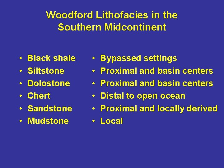
Woodford Lithofacies in the Southern Midcontinent • • • Black shale Siltstone Dolostone Chert Sandstone Mudstone • • • Bypassed settings Proximal and basin centers Distal to open ocean Proximal and locally derived Local
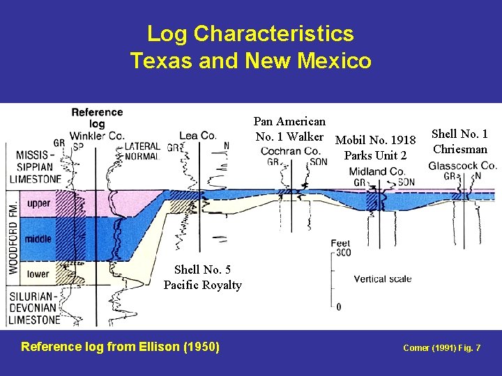
Log Characteristics Texas and New Mexico Pan American No. 1 Walker Mobil No. 1918 Parks Unit 2 Shell No. 1 Chriesman Shell No. 5 Pacific Royalty Reference log from Ellison (1950) Comer (1991) Fig. 7
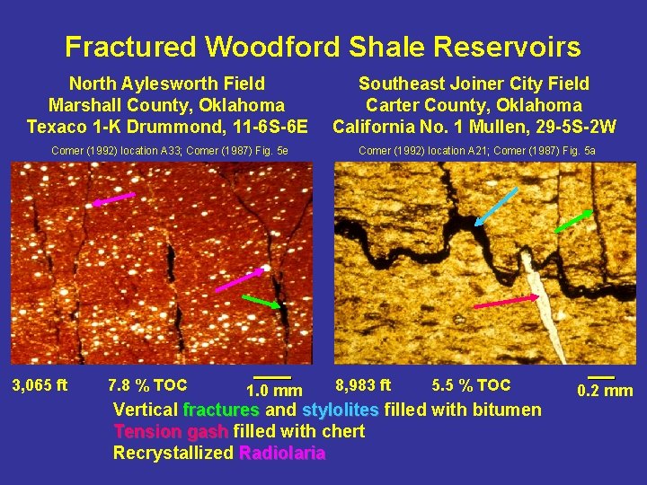
Fractured Woodford Shale Reservoirs North Aylesworth Field Marshall County, Oklahoma Texaco 1 -K Drummond, 11 -6 S-6 E Southeast Joiner City Field Carter County, Oklahoma California No. 1 Mullen, 29 -5 S-2 W Comer (1992) location A 33; Comer (1987) Fig. 5 e Comer (1992) location A 21; Comer (1987) Fig. 5 a 3, 065 ft 7. 8 % TOC 1. 0 mm 8, 983 ft 5. 5 % TOC Vertical fractures and stylolites filled with bitumen Tension gash filled with chert Recrystallized Radiolaria 0. 2 mm
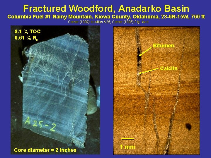
Fractured Woodford, Anadarko Basin Columbia Fuel #1 Rainy Mountain, Kiowa County, Oklahoma, 23 -6 N-15 W, 760 ft Comer (1992) location A 25; Comer (1987) Fig. 4 a-d 8. 1 % TOC 0. 61 % Ro Bitumen Calcite Core diameter = 2 inches 1 mm
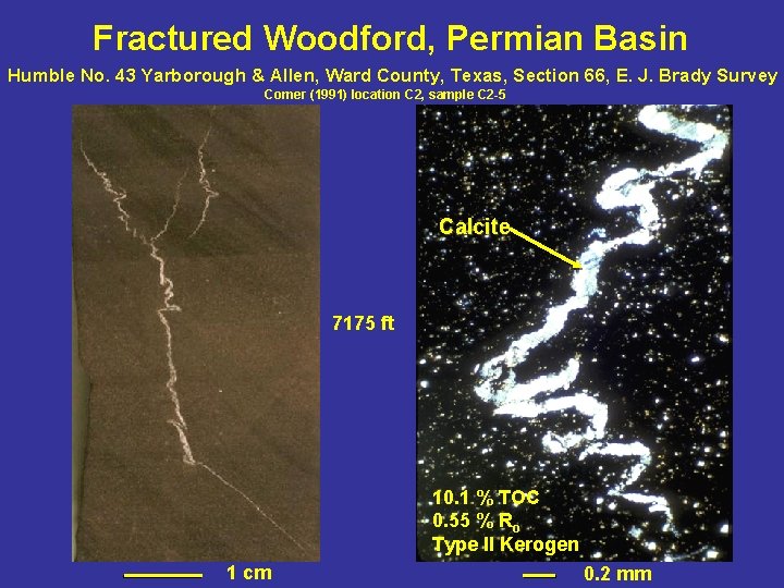
Fractured Woodford, Permian Basin Humble No. 43 Yarborough & Allen, Ward County, Texas, Section 66, E. J. Brady Survey Comer (1991) location C 2, sample C 2 -5 Calcite 7175 ft 10. 1 % TOC 0. 55 % Ro Type II Kerogen 1 cm 0. 2 mm
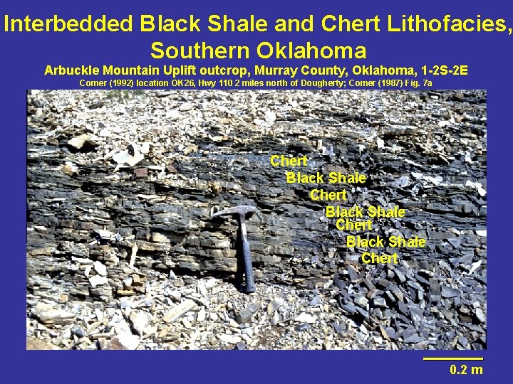
Interbedded Black Shale and Chert Lithofacies, Southern Oklahoma Arbuckle Mountain Uplift outcrop, Murray County, Oklahoma, 1 -2 S-2 E Comer (1992) location OK 26, Hwy 110 2 miles north of Dougherty; Comer (1987) Fig. 7 a Chert Black Shale Chert 0. 2 m
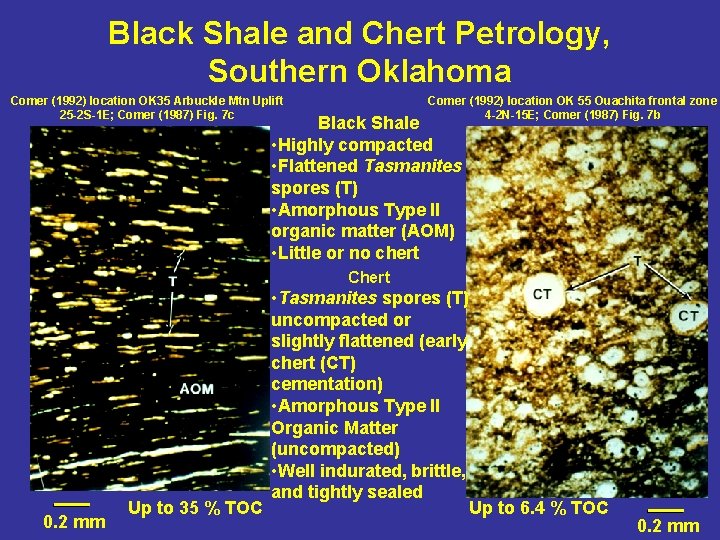
Black Shale and Chert Petrology, Southern Oklahoma Comer (1992) location OK 35 Arbuckle Mtn Uplift 25 -2 S-1 E; Comer (1987) Fig. 7 c Comer (1992) location OK 55 Ouachita frontal zone 4 -2 N-15 E; Comer (1987) Fig. 7 b Black Shale • Highly compacted • Flattened Tasmanites spores (T) • Amorphous Type II organic matter (AOM) • Little or no chert Chert 0. 2 mm Up to 35 % TOC • Tasmanites spores (T) uncompacted or slightly flattened (early chert (CT) cementation) • Amorphous Type II Organic Matter (uncompacted) • Well indurated, brittle, and tightly sealed Up to 6. 4 % TOC 0. 2 mm
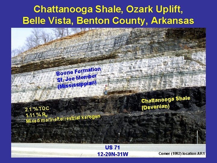
Chattanooga Shale, Ozark Uplift, Belle Vista, Benton County, Arkansas ation m r o F e n Boo ember M e o J. t S pian) p i s s i (M 2. 1 % TOC 1. 11 % Ro l kerogen ia tr s e rr e /t e n ri a Mixed m US 71 12 -20 N-31 W ale Chattanooga Sh (Devonian) Comer (1992) location AR 1
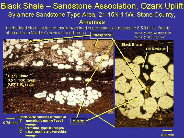
Black Shale – Sandstone Association, Ozark Uplift Sylamore Sandstone Type Area, 21 -15 N-11 W, Stone County, Arkansas Interbedded black shale and medium-grained supermature quartzarenite 8. 5 ft thick; Quartz inherited from Middle Ordovician sandstones Comer (1992) location AR 9 Phosphate Comer (1987) Fig. 3 a-c Black Shale Oil Residue Black Shale 3. 5 % TOC (avg) 0. 83 % Ro (avg) Black Shale consists of zones of (1) amorphous marine Type II 0. 75 mm kerogen (2) terrestrial Type III kerogen (3) mixed marine and terrestrial kerogen Quartz 0. 2 mm
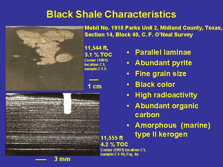
Black Shale Characteristics Mobil No. 1918 Parks Unit 2, Midland County, Texas, Section 14, Block 40, C. F. O’Neal Survey 11, 544 ft, 3. 1 % TOC Comer (1991) location C 1, sample C 1 -5 1 cm • • • Parallel laminae Abundant pyrite Fine grain size Black color High radioactivity Abundant organic carbon • Amorphous (marine) type II kerogen 11, 555 ft 4. 2 % TOC 3 mm Comer (1991) location C 1, sample C 1 -10, Fig. 4 a
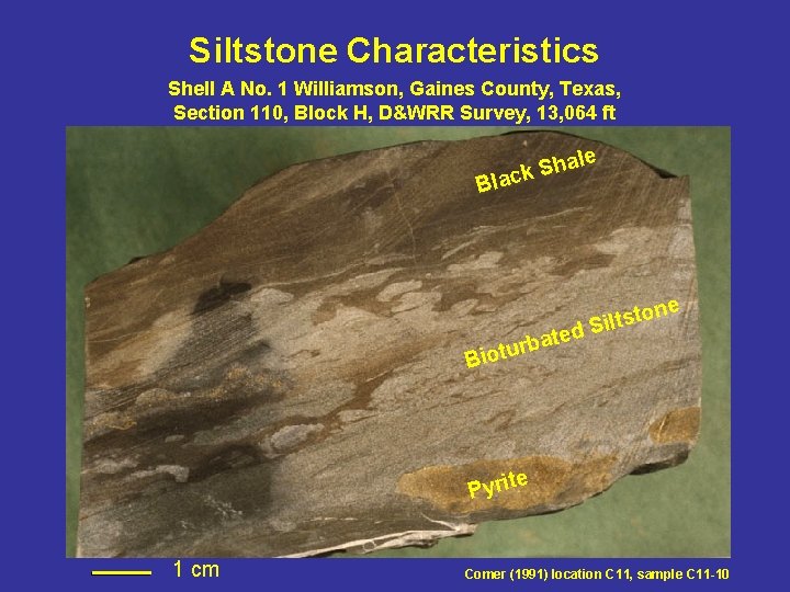
Siltstone Characteristics Shell A No. 1 Williamson, Gaines County, Texas, Section 110, Block H, D&WRR Survey, 13, 064 ft Bla al h S ck d bate r u t Bio e ne o t s t Sil e Pyrit 1 cm Comer (1991) location C 11, sample C 11 -10
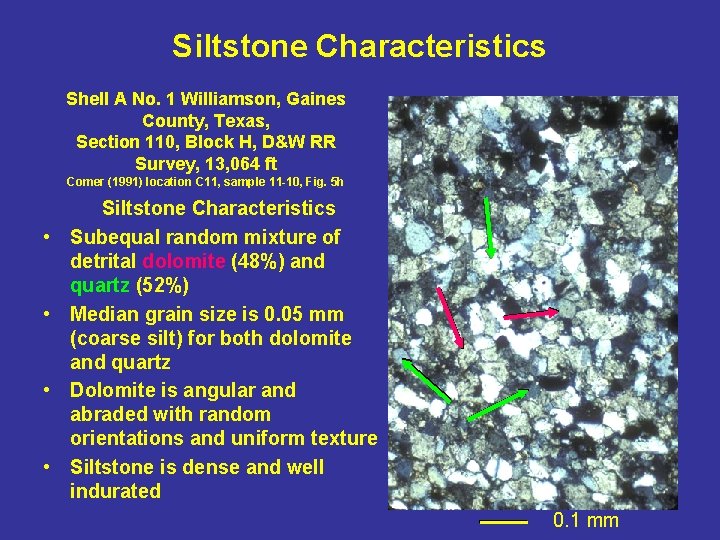
Siltstone Characteristics Shell A No. 1 Williamson, Gaines County, Texas, Section 110, Block H, D&W RR Survey, 13, 064 ft Comer (1991) location C 11, sample 11 -10, Fig. 5 h • • Siltstone Characteristics Subequal random mixture of detrital dolomite (48%) and quartz (52%) Median grain size is 0. 05 mm (coarse silt) for both dolomite and quartz Dolomite is angular and abraded with random orientations and uniform texture Siltstone is dense and well indurated 0. 1 mm
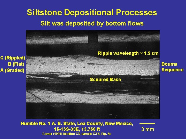
Siltstone Depositional Processes Silt was deposited by bottom flows C (Rippled) B (Flat) A (Graded) Ripple wavelength ~ 1. 5 cm Bouma Sequence Scoured Base Humble No. 1 A. E. State, Lea County, New Mexico, 16 -15 S-33 E, 13, 768 ft Comer (1991) location C 3, sample C 3 -5, Fig. 5 e 3 mm
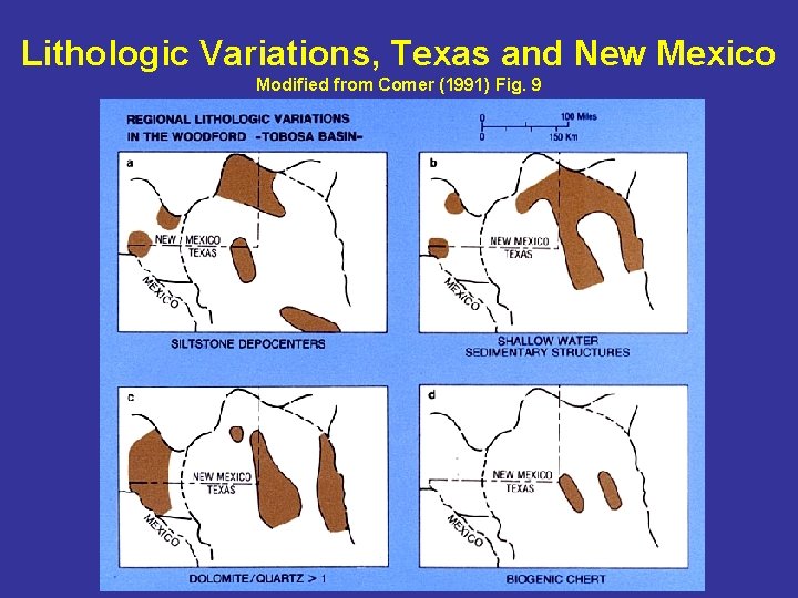
Lithologic Variations, Texas and New Mexico Modified from Comer (1991) Fig. 9
Woodford Resource Potential Modified from Comer (2005)
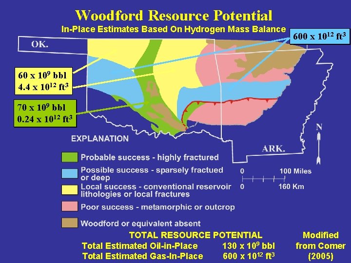
Woodford Resource Potential In-Place Estimates Based On Hydrogen Mass Balance 600 x 1012 ft 3 60 x 109 bbl 4. 4 x 1012 ft 3 70 x 109 bbl 0. 24 x 1012 ft 3 TOTAL RESOURCE POTENTIAL Total Estimated Oil-in-Place 130 x 109 bbl Total Estimated Gas-In-Place 600 x 1012 ft 3 Modified from Comer (2005)
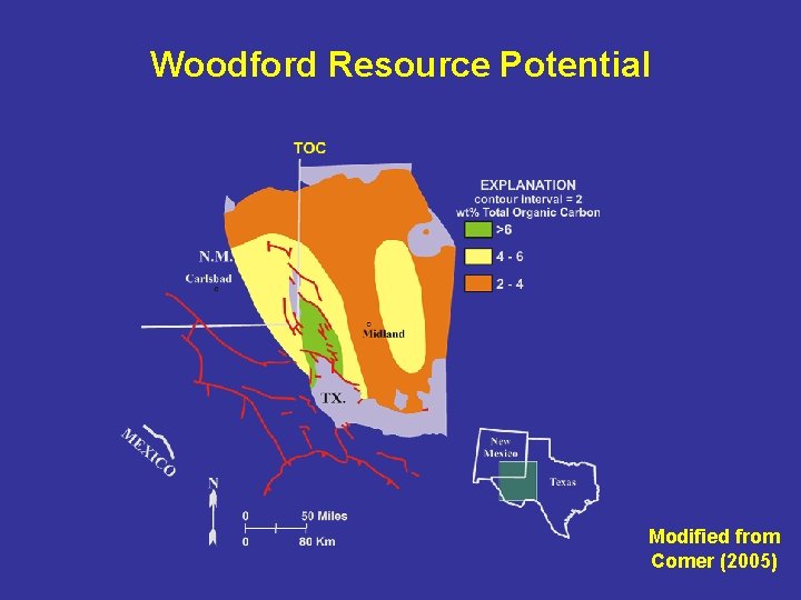
Woodford Resource Potential Modified from Comer (2005)
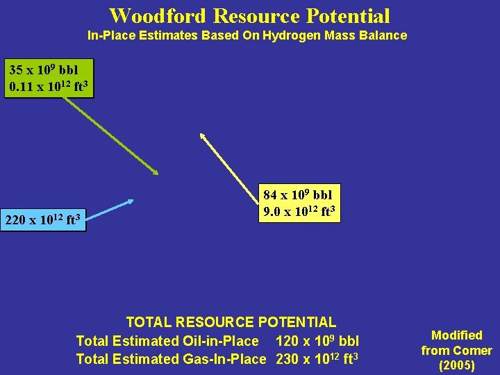
Woodford Resource Potential In-Place Estimates Based On Hydrogen Mass Balance 35 x 109 bbl 0. 11 x 1012 ft 3 220 x 1012 ft 3 84 x 109 bbl 9. 0 x 1012 ft 3 TOTAL RESOURCE POTENTIAL Total Estimated Oil-in-Place 120 x 109 bbl Total Estimated Gas-In-Place 230 x 1012 ft 3 Modified from Comer (2005)
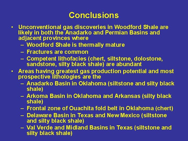
Conclusions • Unconventional gas discoveries in Woodford Shale are likely in both the Anadarko and Permian Basins and adjacent provinces where – Woodford Shale is thermally mature – Fractures are common – Competent lithofacies (chert, siltstone, dolostone, sandstone, silty black shale) are abundant • Areas having greatest gas production potential and most prospective lithologies are the – Anadarko Basin in Oklahoma (siltstone and silty black shale) – Arkoma Basin in Oklahoma and Arkansas (silty black shale) – Frontal zone of Ouachita fold belt in Oklahoma (chert) – Delaware Basin in Texas and New Mexico (siltstone and silty black shale) – Val Verde and Midland Basins in Texas (siltstone and silty black shale)
Key References • Comer, J. B. , 1991, Stratigraphic analysis of the Upper Devonian Woodford Formation, Permian Basin, West Texas and southeastern New Mexico: Austin, Texas, Bureau of Economic Geology, Report of Investigations 201, 63 p. • Comer, J. B. , 1992, Organic geochemistry and paleogeography of Upper Devonian formations in Oklahoma and northwestern Arkansas, in K. S. Johnson, and B. J. Cardott, eds. , Source Rocks in the Southern Midcontinent, 1990 Symposium: Norman, Oklahoma Geological Survey, Circular 93, p. 70 -93. • Comer, J. B. , 2005, Facies distribution and hydrocarbon production potential of Woodford Shale in the southern Midcontinent, in B. J. Cardott, ed. , Unconventional Energy Resources in the Southern Midcontinent, 2004 Symposium: Norman, Oklahoma Geological Survey, Circular 110, p. 51 -62. • Comer, J. B. , and H. H. Hinch, 1987, Recognizing and quantifying expulsion of oil from the Woodford Formation and age-equivalent rocks in Oklahoma and Arkansas: American Association of Petroleum Geologists Bulletin, v. 71, p. 844 -858. • Ellison, S. P. , 1950, Subsurface Woodford black shale, west Texas and southeast New Mexico: Austin, Texas, Bureau of Economic Geology, Report of Investigations 7, 20 p.