Remote Sensing Supervised Image Classification Supervised Image Classification


 0, 0")


 distribution of the")


")


- Slides: 38
Remote Sensing Supervised Image Classification
Supervised Image Classification ► An image classification procedure that requires interaction with the analyst
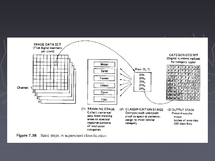
1. General Procedures ► Training stage - The analyst identifies the representative training areas (training set) and develops summary statistics for each category ► Classification stage - Each pixel is categorized into a land cover class ► Output stage - The classified image is presented in GIS or other forms
http: //aria. arizona. edu/slg/Vandriel. ppt
Training
Classifiers ► Minimum distance classifier ► Parallelepiped classifier ► Gaussian maximum likelihood classifier
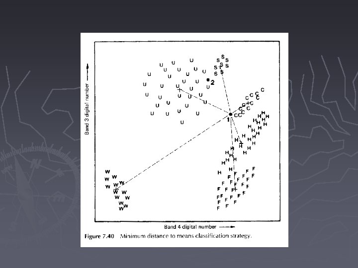
2. Minimum Distance Classifier ► Calculates mean of the spectral values for the training set in each band for each category ► Measures the distance from a pixel of unknown identify to the mean of each category ► Assigns the pixel to the category with the shortest distance ► Assigns a pixel as "unknown" if the pixel is beyond the distances defined by the analyst
(40, 60) 0, 0
Minimum Distance Classifier. . ► Advantage computationally simple and fast ► Disadvantage insensitive to differences in variance among categories
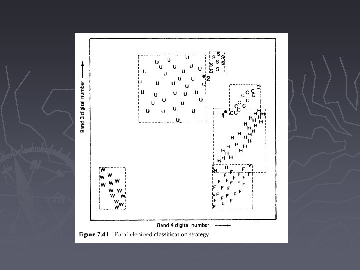
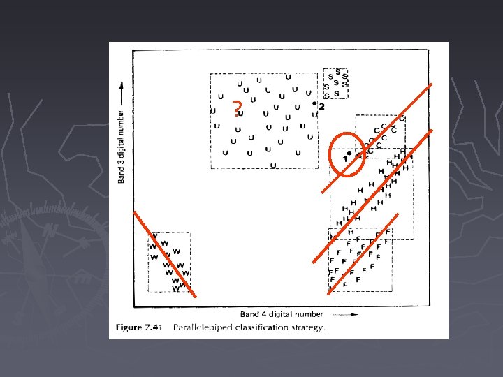
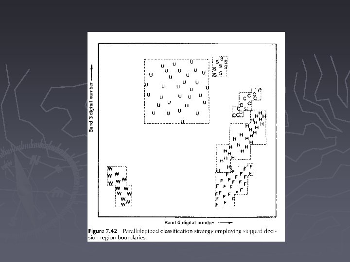
3. Parallelepiped Classifier ► Forms a decision region by the maximum and minimum values of the training set in each band for each category ► Assigns a pixel to the category where the pixel falls in ► Assigns a pixel as "unknown" if it falls outside of all regions
Parallelepiped Classifier. . ► Advantage computationally simple and fast takes differences in variance into account ► Disadvantage performs poorly when the regions overlap because of high correlation between categories (high covariance)
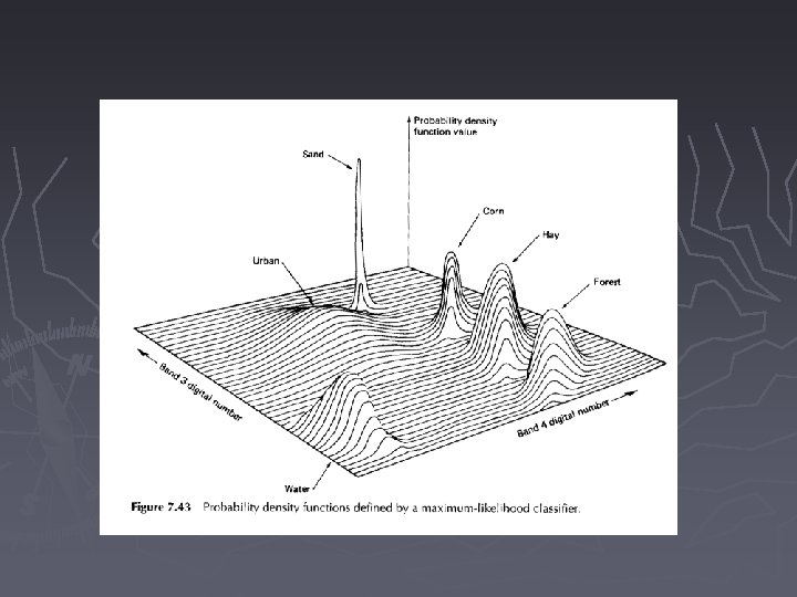
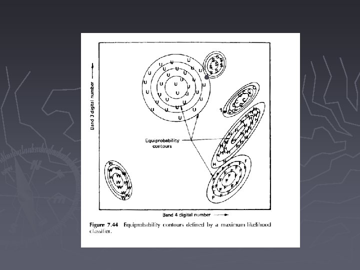
4. Gaussian Maximum likelihood Classifier ► Assumes the (probability density function) distribution of the training set is normal ► Describes the membership of a pixel in a category by probability terms ► The probability is computed based on probability density function for each category
Gaussian Maximum likelihood Classifier. . ► A pixel may occur in several categories but with different probabilities ► Assign a pixel to the category with the highest probability
Gaussian Maximum likelihood Classifier. . ► Advantage takes into account the distance, variance, and covariance ► Disadvantage computationally intensive
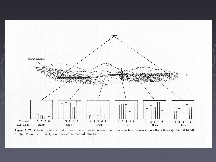
5. Training ► Collect a set of statistics that describe the spectral response pattern for each land cover type to be classified ► Select several spectral classes representative of each land cover category ► Avoid pixels between land cover types
Training. .
Training. . ► A minimum of n+1 pixels must be selected (n=number of bands) ► More pixels will improve statistical representation, 10 n or 100 n are common ► Spatially dispersed training areas throughout the scene better represent the variation of the cover types
6. Training Set Refinement ► Graphic representation ► Quantitative expression ► Self-classification
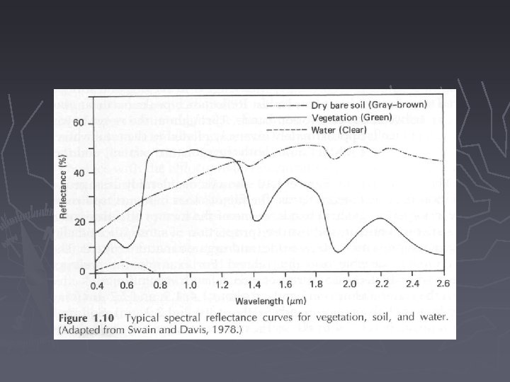
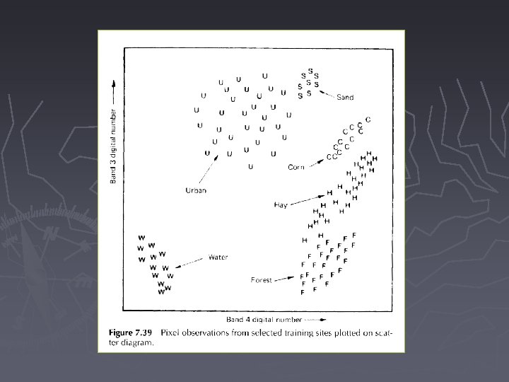
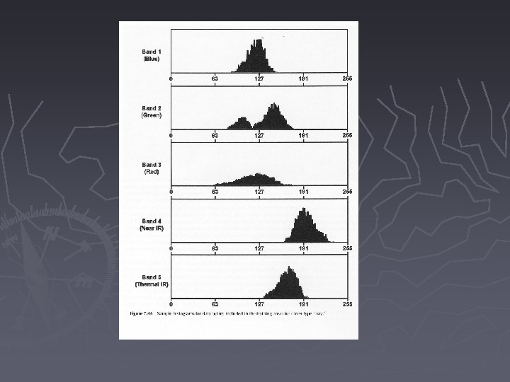
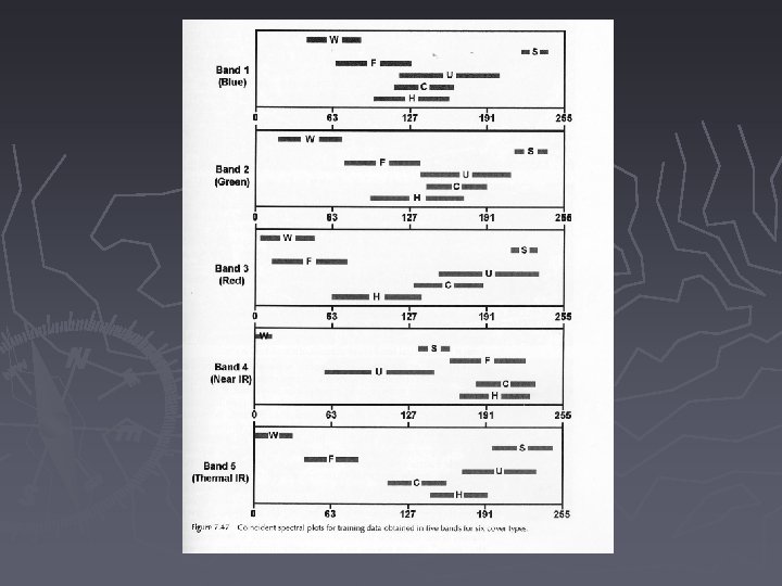
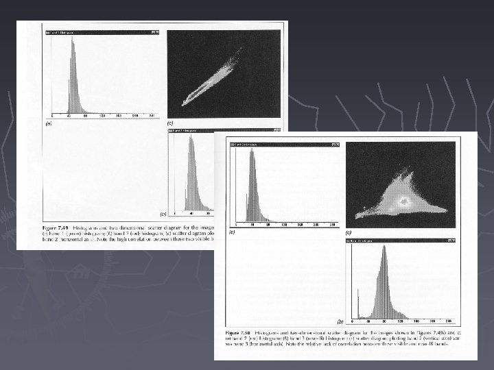
Training Set Refinement. . Graphic representation ► It is necessary to display histograms of training sets to check for normality and purity ► Coincident spectral plot with 2 std dev from the mean is useful to check for category overlap ► 2 -D scatter gram is also useful for refinement
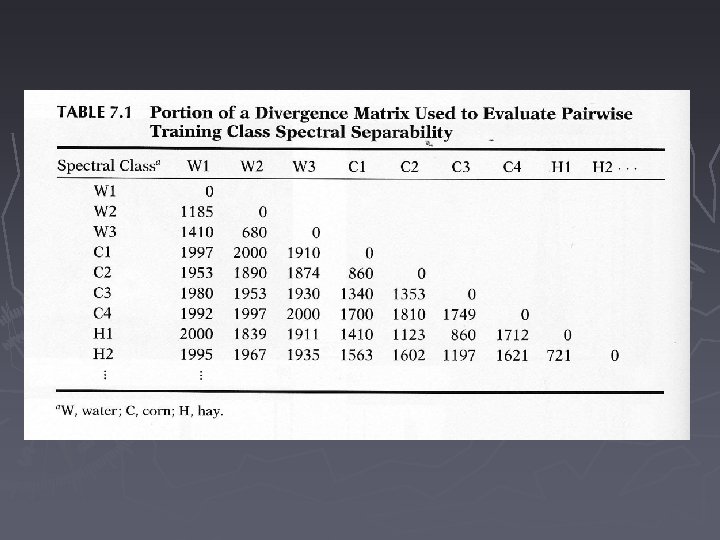
Training Set Refinement. . ► Quantitative expression divergence matrix, higher values indicate greater separability
Training Set Refinement. . ► Training set self-classification - interactive preliminary classification - use simple and fast classifier to classify the entire scene ► Representative sub-scene classification
1. Post-Classification Smoothing ► Majority filter: use a moving window to filter out the “salt and pepper” minority pixels ► By assigning the majority category of the window to the center pixel of the window
Readings ► Chapter 7