Remote Sensing in Geology Highlights of Lesson 8

: Supervised Minimal distance to means")


, also")


 • Domes")

")
")
")


- Slides: 25
Remote Sensing in Geology
Highlights of Lesson 8 Image processing (image classification): Supervised Minimal distance to means Parallelepiped Maximal likelihood & Bayesian Unsupervised Hybrid
Lesson № 9
Geological applications • Scope of Geological applications: • Surveying Geology • Mineral exploration • Explorations in Engineering Geology & Hydrogeology • Other related environmental explorations (Land Use, Land Cover Vegetation…)
Surveying Geology • Criteria • Geomorphological • Tone & color • Vegetation • Derived criteria • Spectral manipulations (spectral stratigraphy)
Surveying Geology • Geomorphological • The relief is reflection of geological setting – different landforms imply different bedrock The object is the surface of the Earth and the phenomena upon it. Since the surface features, shapes, patterns &c. are governed by the internal and external factors, the present surface of the landscape is considered as a temporal function: F(processes, properties, time) Since it varies significantly even over small area it must be due to the properties i. e. to the geological setting share.
Surveying Geology • Geomorphological • Changes in morphological pattern within the same process Changes in drainage pattern density or shape, changes in steepness of the landforms • Landforms are separate units Quaternary sediments represented by different accumulation or erosion forms or recent volcanism
Surveying Geology • Different drainage patterns indicate different features (structural or lithological), also different level of development of those patterns reflects the texture properties of rocks (coarse vs. fine grained for example)
Surveying Geology • Drainage patterns • dendritic • rectangular & angulate • parallel • trellis • annular & radial • meandering • distributary • anastomotic • deranged • braided • barbed • linear
Surveying Geology • Tone & color • Color directly corresponds to the chemical (mineralogical) content of the unit, while tone expresses structural features (e. g. grain size) Content of felsic (pale) and mafic (dark) minerals is fair indication for the color expression. • Abrupt changes of tone (due to shadow effect) and color indicate structures
Surveying Geology • Vegetation types are reflection of the environmental conditions, hence geological bedrock as well. • Vegetation distribution delineates the structures with pronounced hydrological function (faults) especially if contrasting the surroundings.
Surveying Geology • Derived criteria • Feature extracted by specific or several criteria utilizes interpreter to involve it in further analysis. Bedding, derived after differences in resistivity and/or tone and vegetation alternation becomes typical criteria for a certain layered unit. Other structural elements as well (joints, faults, folds &c)
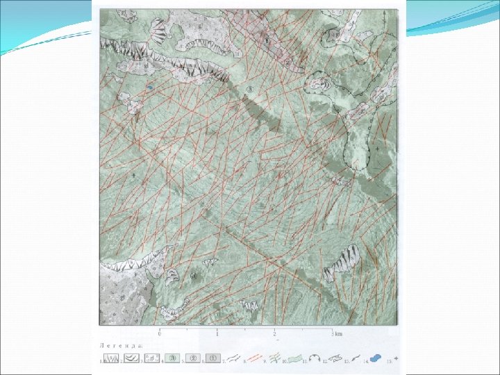
Surveying Geology • Structures: • Rupture elements • Plicative elements • Lithological units
Surveying Geology - Structures • Rupture elements • Beddings • Foliations • Faults • Joints • Circular & radial features
Surveying Geology - Structures • Rupture elements • Spatial and relative disposition (V-rule model) • Character
Surveying Geology - Structures • Plicative elements • Folds (synclines, anticlines) • Domes & bassins
Surveying Geology – Lithological units • Rock types • Sedimentary • Igneous • Metamorphic • Quaternary units
Surveying Geology – Lithological units • Sedimentary: Sandstones (humid & arid)
Surveying Geology – Lithological units • Sedimentary: Limestones (humid & arid)
Surveying Geology – Lithological units • Igneous: Intrusive (granitic)
Surveying Geology – Lithological units • Igneous: Volcanic
Surveying Geology – Lithological units • Metamorphic
Surveying Geology – Lithological units • Quaternary
Surveying Geology – Interpretation • Structure analysis • Lithological analysis