Remote Sensing Aerial Photographs Interpretation 1 Aerial Photo


- Slides: 26
Remote Sensing Aerial Photographs Interpretation
1. Aerial Photo Interpretation ► Three kinds of knowledge required - subject - geographic region - remote sensing system
1. Aerial Photo Interpretation Three issues unique to image interpretation - perspective: overhead view - spectrum: beyond visible - scale and resolution: different appearance ►
2. Elements of Image Interpretation Shape ► Size ► Pattern ► Tone ► Texture ► Shadow ► Site ► Association ►
2. Elements. . ► Shape - form, configuration, outline, or height
2. Elements. . ► Size - relative size to other objects
2. Elements. . ► Pattern - - arrangement of objects into distinctive and recurring forms
2. Elements. . ► Tone - B/W photo: different shades of gray, color for color photo - image tone can be affected by illumination condition and film processing - human interpreter is less sensitive to subtle change in tone
2. Elements. . ► Texture - frequency of tonal change, roughness - human interpreter is good at subtle change in texture - illuminating angle affects texture
2. Elements. . ► Shadow - reveals size and shape of objects - feature within shadows are difficult to discern
2. Elements. . ► Site - topographic, geographic positions
2. Elements. . ► Association - characteristic occurrence of objects relative to others
Color Aerial Photographs
NIR Aerial Photographs Photo taken as part of the NAPP mission in color IR at a scale of 1: 40, 000. (1”=3, 333’). This image has been enlarged by x factor.
Aerial Photographs
Aerial photographs Stephen Hutcheon October 25, 2006 - 12: 40 PM Google Earth spotters have discovered a strange rock formation in the prairies of central Canada that resembles a native American in headdress listening to an i. Pod. The rock formation is in Alberta, Canada about 300 km southeast of Calgary, near the border with Saskatchewan. Dubbed the Alberta Indian, the formation was discovered by a Google Earth spotter nicknamed Supergranny. The area is situated in one of Canada's key gas fields. The nearest urban centre is Medicine Hat, a town of 56, 000 known as "The Gas City" which claims to be Canada's sunniest spot. The rock formation's "face" measures about 255 m across and its about 225 m long. The feature which resembles an i. Pod earphone is actually a road leading up to what one Google Earth spotter who is knowledgeable about the region says is a natural gas wellhead. In the Google Earth forum, the person names the well as Piper Medhat 6 -20 -12 -1. Another Google Earth spotter who appears to have some knowledge of geology write that the figure "seems to consist of an area naturally eroded out of the south side of a flat-topped mesa". (According to the Macquarie Dictionary, a mesa is a land form having a relatively flat top and bounded wholly or in part with steep rock walls, common in arid and semi-arid parts of the world. ) "I can see no sign of it having been created by modern or ancient people. In generally, the shapes making up the Alberta Indian conform to the sort of cursive, fractal erosion features found all around that part of Alberta, " the spotter called Lo. Rez. Flyer writes on the Google Earth forum. Google Earth - a program which combines satellite and aerial photography - offers armchair explorers a new frontier of discovery. http: //www. theage. com. au/articles/2006/10/25/1161743788326. html
3. Purposes of Image Interpretation ► Three purposes of interpretation - view the photograph - measurement (e. g. coordinates and height) - mapping (e. g. orthophoto, DEM)
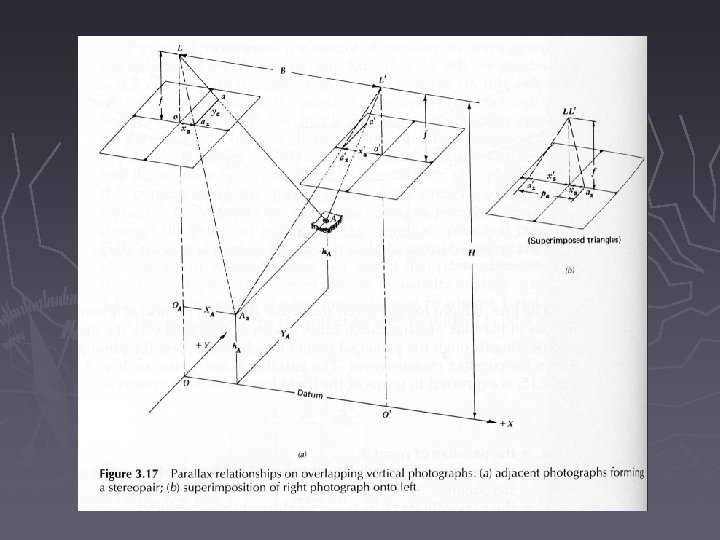
Measurement Overlapping photos ► Forward overlap: 50 -60% along flight line; sidelap: 5 -15% ►
Measurement
Measurement
Mapping - Orthophotographs ► Aerial photographs without geometric errors introduced by tilt or relief displacement ► Orthophotomaps and digital orthophoto Quarter Quad (DOQQ) - show correct planimetric position and consistent scale - a source to cerate DEM
Orthophotographs
4. Sources of Aerial Photography ► EROS Data Center - Sioux Falls, SD, operated by USGS ► Two programs related to aerial photos: 1. National Aerial Photography Program 2. National High Altitude Photography Program http: //nationalmap. gov/viewer. html
4. Sources of Aerial Photography ► Two sources for the NY state GIS data including DOQs http: //cugir. mannlib. cornell. edu/ http: //www. nysgis. state. ny. us/
Readings ► Chapter 3