Regions of Texas The Great Plains p 61


- Slides: 10
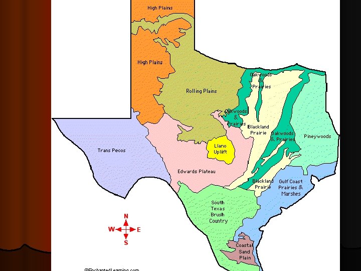
Regions of Texas The Great Plains p. 61 - 65
l This The Real “Old West” region is found east of the Rocky Mountains. The Caprock Escarpment divides the Great Plains to the east. l The Great Plains – often called “a sea of grass” – were once home to immense herds of buffalo and nomadic Native Americans. l Today much of the land is used to grow cotton and wheat. l Located far from the moist Gulf winds, the Great Plains region is a dry area. l Droughts are often a problem; only irrigation from underground water sources and new techniques make farming possible.
The Real “Old West” l Because of its high elevation, the Great Plains often have cooler summers than other parts of Texas, and the winters are cold. l 3 geological subsections lie within this region: l Edwards Plateau l Llano Basin l High Plains
The Edwards Plateau l It has a thin layer of soil making most of the area ill-suited for farming. l Almost the entire region is covered with weeds and tree foliage which provide food for sheep. l The economy of the area depends largely on cattle, goat and sheep raising.
The Edwards Plateau l This section is among the nations most important wool-producing areas. l Del Rio is the area’s largest city. l As the Edwards Plateau nears the Caprock Escarpment, it becomes a hilly area of eroded limestone called the Hill Country.
The Llano Basin l Smallest geographic section l l Smallest geographic section in Texas. The land is lower here because of erosion. The terrain consists of rolling plains broken up by hills. Part of the area is occupied by large lakes and reservoirs on the Colorado River. The combination of lakes and hills has given this section the name Highland Lakes Country.
The High Plains l Occupies most of the Panhandle. l The land is mostly flat except for 2 areas that have quite different characteristics: l Canadian Breaks – rugged area that follows the Canadian River. l Palo Duro Canyon – rugged area that has been carved by the Red River. l The High Plains section is divided into 2 major parts: l North Plains – wheat and grain sorghum produced l South Plains – World’s largest cottonseed producing industry.
Using your pencil or pen, shade the Great Plains region on your map.