Regional Geography Revision Ms V Redmond Presentation Wexford


/ Belgium GAELTACHT")
 Flanders (North) - Wallonia (South) - German Enclave")


 Only")


- Slides: 76
Regional Geography Revision Ms. V. Redmond, Presentation Wexford, 2011
Types of Region: • CLIMATIC REGIONS • PHYSICAL REGIONS • ADMINISTRATIVE REGIONS • CULTURAL REGIONS • SOCIO-ECONOMIC REGIONS I. E. CORE/PERIPHERY, INDUSTRIALLY DECLINED REGIONS • URBAN REGIONS
Definition to learn: • A Region is an area on the earth’s surface which is different to all areas around it. It has different characteristics e. g. physical (climate soils, rocks, drainage), cultural, administrative, economic, human.
World Climatic Regions
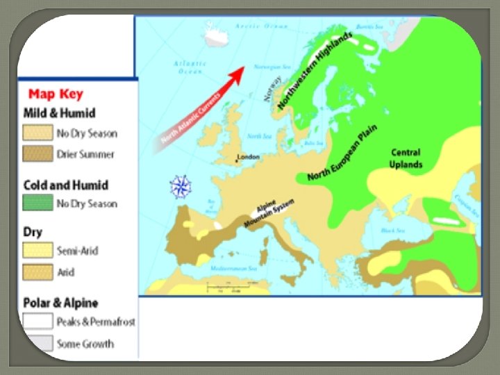
COOL TEMPERATE OCEANIC Climate • Where: Western Europe - From Northern Norway to North West Spain (including Ireland) • Temperatures: Summer average 15 - 17 (can go to 23) Degrees, lower averages along coasts, higher inland (South Westerlies=Trade winds / North Atlantic Drift=warm current). Winter average 4 - 5 Degrees - Moderating influences of S. Westerlies / North Atlantic Drift current. • Precipitation: all year round - Cyclonic and Relief Rainfall but with Winter Maximum 750 mm (Rain Shadow Dublin)- 2, 600 mm (West) • Effects: Positive (irrigation) and negative (leaching) effects of precipitation on soils
PHYSICAL REGIONS CASE STUDY - THE BURREN • Upland terraced limestone region with beds of rock dipping gently • • • to South and covered by shale in some parts - KARST LANDSCAPE Formed when African and European Plates collided - Munster mountains were folded at this time also (Armorican Foldings) Soil cover eroded by glaciers and early farmers and strong coastal winds Large expanses of Limestone Pavements (Clints & Grikes) containing Swallow Holes, Uvalas, Poljes and few surface streams Underground Passages and Caverns Unique Flora and Fauna 7
CARBONATION • Underground and Surface features result from the process of CARBONATION H 2 O + CO 2 � ¨ H 2 CO 3 [carbonic acid] which dissociates to: H 2 CO 3 � ¨ H+ + HCO 3 - and the proton reacts with calcite: Ca. CO 3 (s) + 2 H+ (aq) � ¨ Ca++ (aq) + CO 2 (g) + H 2 O
ADMINISTRATIVE REGIONS CASE STUDIES IRELAND & FRANCE • IRELAND - SINGLE TIER SYSTEM Central Government County Councils/City Councils/ Boroughs 9
Administrative Units - Ireland • Dates back to Norman times 12 th Century • By mid 13 th Century we had 8 counties • 1606 - 1994 26 counties • 1994 Dublin subdivided into 3 new counties Dublin, Fingal, Dun Laoghaire - Rathdown • Many county boundaries are distinguished by natural physical boundaries eg River Slaney/ Wicklow Mountains
Dublin's Administrative Regions Jim Ryan SPC 11
Urban Based Administrative Units • CITY COUNCILS - 5 - Dublin, Cork, Waterford, Galway, Limerick - The suburbs of these areas have grown so much that in some cases they are spreading into neighbouring councils eg Limerick into Clare County Council • BOROUGH & TOWN COUNCILS BOROUGH COUNCILS -The 5 medium sized towns below the city councils eg Wexford Town TOWN COUNCILS - 75 of these eg New Ross • REGIONAL ADMINISTRATIONS - Not an effective Regional level of admin in Ireland. We have Regional Authorities but they really only cater for specific elements eg Health and Tourism Jim Ryan SPC 12
FRANCE - ADMINISTRATIVE SYSTEM Multiple Tier System Central Government 22 Regional Governments 92 Departments
Departments & Regional Govts. • System dates back to French Revolution after which the pattern • • • of local government based on the department was developed. These were all approximately the same size in terms of area and population and also ensured that all areas within them had the same focus on culture Responsible for a number of functions - social services/coordinating urban and regional planning Prefet is the administrative officer and is centrally appointed One main town is the focus for each department Aftre World War 2 (1955) 22 Regional Centres were formed but had little power 1970 - Policy of Decentralisation to give them more power Regional Assemblies and Direct Elections Helped develop cities such as TOULOUSE
Cultural Regions Mostly defined by distinctive Language/Religion Language Regions - Gaeltacht (Ireland)/ Belgium GAELTACHT 1. 6 Million claim to speak Gaeilge! Only used everyday in Fior Gaeltacht 1925 ( Commission for Irish Speaking Districts) - Broken into Fior Gaeltacht and Breac Gaeltacht Regions reducing in size (2002 Census 86, 500 people) Why? Government system of Positive Discrimination in Gaeltacht Region - Grants/Incentives • • •
Language Regions - Belgium (Independence 1830) Flanders (North) - Wallonia (South) - German Enclave • Flanders • Flemish speaking, culturally • • linked to Netherlands Historically poor - Prospered since 1960’s attracting growth industries to places such as Antwerp Brussels is the capital of Belgium and located here but is Bilingual • Wallonia • Mainly French speaking • During 1800’s became prosperous • based on coal & steel in Sambre. Meuse Valley Collapse of these industries in 1950’s led to massive decline (Maladjusted Region) • German Enclave • Territory received from Germany after WW 1
Tensions Caused by Cultural Differences in Belgium • Flanders has received much industrial investment but still • • • feels under threat from the more dominant French language in the south Possible break up of Belgium has been averted many times This led to fundamental governmental reforms and the creation of a Federal Government which recognises all three regions - each has a certain amount of Autonomy Flemish display a defensive attitude over the spread of French and have created a new Pro Flemish political party - Vlaams Belang
REGIONS IN IRELAND c. CCC 18
CORE - PERIPHERY MODEL • A model that helps explain differences in • • • economic development Economic development does not affect all areas in the same way. Some regions develop strongly because of a number or factors eg. Raw materials/strategic location for trade Other areas may not develop to the same extent because of poor resources/unfavourable environments/poor access to trade routes
Regions shown on maps depends on scale Large scale shows a large area but little detail e. g. world map – 1: 1, 000 cm Small scale shows a small area but a lot of detail e. g. street map of Dublin – 1: 16000
Jim Ryan SPC 21
CHARACTERISTICS OF A REGION • All regions have different chacteristics but some characteristics are the same. AREA: Regions occupy an area of the earths surface that is different from all other areas around it. BOUNDARIES: Regions are seperated by boundaries from surrounding regions. Some boundaries are clear e. g. mountain ranges, rivers. Some boundaries are not clear e. g. local government boundaries e. g. Mayo co. council v Castlebar Town Council. IMAGE: By naming a region people can conjure up an idea of a place e. g. France – Eiffel Tower, Garlic , USA – Mc. Donalds, Disneyland, Gaeltacht – Aran sweaters, Thatched cottages. CHANGE: Regions change over time e. g. Dublin –Why? – Transport, Industry. Urban Sprawl, Satellite Towns, Suburbs, Commutor Belts.
REGIONAL DEFINITIONS • CORE REGIONS - A core region is the wealthiest part of an area of land. It is the centre of economic, political and administrative life in a region e. g. Dublin, Paris Basin, Manchester-Milan-Berlin axis = core of EU. • Usually the capital of a country is in the core region.
PERIPHERAL REGIONS • A peripheral region is a region which is distant from the core and lacks economic, political and administrative investment e. g. BMW, Mezzogiorno, Greece, Scottish Highlands • Usually the poorest part of the country. • Usually will have negative aspects to its physical geography eg drought, boggy soils
MALADJUSTED REGIONS OF INDUSTRIAL DECLINE: These are regions which were once dependent on an industry or natural resource which is now in decline or has declined e. g. Sambre - Meuse (coal), Greater Cork Area
Core - Periphery Model Ireland • CORE - South & East • Periphery - BMW Study under these headings • Physical Processes • Economic Processes • Human Processes
Regional Contrasts in Ireland BMW - SOUTH & EAST
Human Processes – Topics to Include in an Answer • • Migration – Causes and Consequences Birth Rates/Death Rates Rural Depopulation Urbanisation – Positives/Negatives Openess to Change Education Opportunities Employment Opportunities
• • • BMW – Human Processes Population Decline since Famine Times – Migration Aprx. 50% of total area but 27% of population Few large urban areas – Galway biggest @ 50, 000 (Dominant Urban Area) Lack of Education Facilities – One of the seven Universities – Most young students leave for education and do not come back Low rates of natural increase due to low birth rates due to so few young people left – Ageing Population Gaeltacht areas find it very difficult to attract FDI (Foreign Direct Investment) Some In migration during 1996 -2006 due to Celtic Tiger Economy Population decrease = Decpletion of Infrastructure Tradition = Extensive Agriculture = Poor Development
CORE REGION - PARIS BASIN
Jim Ryan SPC
• • • PARIS BASIN – Human Processes Population of the City of Paris (Ile de France) doubled between 1921 -2004 to aprx. 12 Million but the Greater Urban area has a population of 22 Million- 1/3 of French population (Huge suburbs and New Towns – Evry/Marne-lá-Valée) Ile de France – High density/Birth Rate 15 per 1, 000 – Death Rate 7 per 1, 000 - Natural Increase of 0. 8% means an increase in population before migration is taken into account Contrast with France in general- Birth Rate 12 per 1, 000 and death rate of 9 per 1, 000 Outskirts of the Paris Basin are experiencing net Emmigration while Ile de France is experiencing net Immigration 40% of all foreign migrants in France live in Paris Region 13% of the region's population are migrants – mostly from North and West Africa (Former Colonies) and Portugal
PARIS BASIN – Human Processes cntd. • • Lack of jobs and stricter migration control has slowed migration into the region in past ten years Many French people have left parts of the Ile de. France and some of these areas have been replaced by migrant ghettos Unemployment has led to ethnic instability and Paris riots in early 2000's Rise of Islamic Fundamentalism – Dress codes in schools Overcrowding/High Cost of living/Inner city decline/deindustrialisation = Major Human problems Urban Renewal projects have tried to improve parts of the city – Develipment of 8 Nodes (centres) in the greater Paris region (modern housing/employment opportunities/improved services) Example of one is Lá Defense Also New Towns built outside the Ile de France with populations of over 100, 000/good range of services and employment eg. Evry/Marne-le-Vallée)
REGIONS OF INDUSTRIAL DECLINE • Ireland - Greater Cork Area • Belgium - Sambre-Meuse Valley • United Kingdom - South Wales
Case Study 1. Sambre - Meuse Valley • Core Region of Belgium has changed from Wallonia - Flanders • 1750 - 1950’s major coal and steel/associated industries base • • • around major coalfields of the area - Kampen/Liege/Sambre- Meuse Engineering/chemicals/iron and steel Decline due to new cheaper imports/decline in coal and steel/new cheaper sources of energy (oil/gas)/ new technologies = DEINDUSTRIALISATION Flow of people to North/Loss of industry to North led to Flanders becoming the new core of Belgium Wallonia became an Objective 2 Region - Attempts by government and EU to REINDUSTRIALISE the region eg. Charleroi Airport/Caterpillar Since 1960 Flanders has experienced significant economic growth Antwerp/Zelzate
Sambre-Meuse Valley - A Response to Industrial Decline? • • • EU designated the area Objective 2 (Convergence Region) – Structural Funds from The Common Regional Policy Investment in transport network -motorways to Randstad/Rhur/Paris Development of new Industrial Estates near citiies such as Charleroi/La Louviere Upgrading of airports to International standard eg. Charleroi (Ryanair Hub) Cleaning up of derelict landscape to make it more attractive for investment Jim Ryan SPC 37
Case Study 2 Greater Cork Area • 1973 - Ireland joined EEC - Began process of INDUSTRIALISATION • Verholme Shipyard/Oil Refinery/Ford/Dunlop/Irish Steel/Sunbeam • • • Textiles added to traditional industries eg processing - Cork became a Growth Centre for the National Economy 1980’s Recession - Industrial decline hit the Cork area. Long established industries closed down. MNC’s eg. Ford & Dunlop closed the branch plants in Cork - DEINDUSTRIALISATION Massive unemployment 1990’S - REINDUSTRIALISATION - due to booming world economy Lots of FDI (Foreign Direct Investment) led by IDA PFIZER/JOHNSON&JOHNSON/WYETH/APPLE/BOSTON SCIENTIFIC Unlike Wallonia Cork has recovered Jim Ryan SPC 38
Urban Regions - Case Study Dublin • 60% of Irish people live in cities and towns - Dublin has by far the • • • largest proportion - Primate City Ireland - One of least urbanised in Europe (European Average 80%) Dublin’s development traced back to Vikings - Site. Woodquay, Christchurch/ Lowest bridging point -Further developed by Nornans and Plantations Situation - Deep sheltered bay on East Coast development of infrastructure focused here/Liffey Valley providing access to central lowlands/ Agricultural Hinterland - Market City Large population - led to development of Industries and Services eg Guinness/Intel - IFSC/Transport system centralised in Dublin Urban Sprawl - Eastwards and Jim Northwards and along coast but Ryan SPC restricted by Irish Sea and Dublin/Wicklow mountains 39
PERIPHERAL REGION MEZZOGIORNO Jim Ryan SPC 40
Mezzogiorno/Gulf of Metapontino/Tarranto 2 Drainage Features Agri/Sinni Rivers flowing into Gulf of Metapontino Jim Ryan SPC 41
MEZZOGIORNO- Land of Midday Sun 40% of Italy's territory • 36% of population • 25% of GDP • 50% of agricultural employment • Jim Ryan SPC 42
THE MEZZOGIORNO Primary Activities • Pre 1950's – most employed in • • • Post 1950 land reform/Casa per Farming/Fishing Very Low incomes – 50% of average Latifundia – Extensive Farming-Hiltops Only 1/4 owned own land 70% of holdings smaller than 3 Hectares of poor land Minifundia – overgrazing/overcultivation= soil erosion • • • il Mezzogiorno Land redistribution larger holdings 5 -50 hectares Retraining = more Intensive farming-new machinery/new crops-citrus and olives/vines(cash crops) for large EU market- 2 seasons Irrigation eg Gulf of Metapontino(was malaria swamp)-5 rivers (coastal lowlans now the most successful area) Jim Ryan SPC 43
THE MEZZOGIORNO Primary Activities • Pre 1950's – most employed in • • • Post 1950 land reform/Casa per Farming/Fishing Very Low incomes – 50% of average Latifundia – Extensive Farming-Hiltops Only 1/4 owned own land 70% of holdings smaller than 3 Hectares of poor land Minifundia – overgrazing/overcultivation= soil erosion • • • il Mezzogiorno Land redistribution larger holdings 5 -50 hectares Retraining = more Intensive farming-new machinery/new crops-citrus and olives/vines(cash crops) for large EU market- 2 seasons Irrigation eg Gulf of Metapontino(was malaria swamp)-5 rivers (coastal lowlans now the most successful area) Jim Ryan SPC 44
• Between 1960 -2000 workforce Mezzogiorno-Secondary Sector almost tripled to • By 1950's only 17% of Italian • • workforce in Mezzogiorno Government help-Casa per il. Mezzogiorno/Grants/Tax. Reli ef Infrastructure developed. Autostrada/Ports/Airports State companies 80% of new investment Development of Industrial Zones-Brindisi/Palermo/Bari/ Naples 1. 4 ml/reduction on Primary sector dependance • 75% 0 f new jobs in Steel /Chemicals/Engineering – located on coast • Inland areas remain depressed • Most successful area= Bari/Brindisi/Taranto Deep water port@ Taranto=Oil Refining/Steel. Mill • Car Assembly@ Latina. Fronsione 16, 000 workers • Oil Refining/Potash@Siracusa Jim Ryan SPC 45
• • • Mezzogiorno Tertiary Sector Traditionally very poorly developed – Fascist regime of Mussolini and Mafia influence didn't help Under Casa major investment in transport system – Autostrada del Sol running from Swiss Border to toe of Calabria. Also other large motorway connecting West to East of Mezzogiorno. Both help to connect it to the Core Port developments in South West have improved accessibility – Taranto/Bari/Brindisi Long hot dry summers thanks to anticyclone settling over the South has helped develop tourist numbers Also the historical Roman sites, expansive underdeveloped beaches and coastal scenery have helped develop the tourist sector Cheaper than other Italian holiday areas eg. The Northern Lakes and Amalfi coast Jim Ryan SPC 46
• • • Mezzogiorno – Tertiary Sector cntd. Over 12 Million tourists now visit the Mezzogiorno annually 9 Million come from other parts of Italy – Need to further develop foreign tourists to help bring in further revenue Geomorphological sites are very popular eg. Mt Vesuvius near Naples and Mt. Etna in Sicily Herculaneum and Pompeii and the Isle of Capri are hugely popular with tourists and bring valuable revenue to this area The area is not overly commercialised unlike high profile tourist areas of Spain, Portugal and France so still has a natural feel to it The tourist season in the Mezzogiorno should be able to overcome seasonality which is a problem in other areas. This is due to warm weather for large parts of the year particularly in the East which also receives less rainfall due to the rain shadow of the Apennines Jim Ryan SPC 47
Subcontinental Region - India Jim Ryan SPC 48
India – A Sub Continental Region
India A Subcontinental Region - Physical Jim Ryan SPC 50
INDIA - BASIC STATISTICS Geographical Location: Between latitudes 804’ and 3706’ North and longitudes 6807’ and 97025’ East. Land Area: 3. 29 Million Square Kilometers. Climate: Mainly tropical with temperatures ranging from 100 C – 400 C in most parts of the country. Capital: New Delhi. Population: 1. 147 Billion (estimated as at March 2008). Population growth rate: 1. 606% per annum. Population density: 348 persons / square kilometer. (Population / land area in sqkm) Life expectancy at birth: 66. 28 years, male; 71. 17 years, female. Literacy rate: 65. 47% (as per 2001 Census). Languages spoken: Eighteen principal languages; majority speak Hindi; business language: English. Major religions: Hinduism, Islam, Christianity, Sikhism, Buddhism and Jainism. International Airports: Ahmedabad, Amritsar, Bangalore, Chennai, Dabolim, Guwahati, Hyderabad, Kochi, Kolkata, Mumbai, Nagpur, New Delhi, Shrinagar and Thiruvananthapuram. Major Seaports: Chennai, Ennore, Haldia, Kandla, Kochi, Kolkata, Marmagao, Mumbai, New Mangalore, Paradip, Tuticorin and Vishakhapatnam.
India Physical Processes • • • 3 Main Regions – Northern Mountains/Indus-Ganges Plain/ Southern Plateau NORTHERN MOUNTAINS Extremely high and separate India from neighbours Extend from Hindu Kush in North West to Himalayas in North East containing Mt Everest and next 23 highest peaks in world Formed by tectonic collision of Eurasian Plate (Continental) and Indian Plate (Oceanic) Collision caused uplifting at the convergent boundary and formed fold mts approx. 35 Million years ago (Alpine Fold System)
India Physical Processes cntd. • • Indus-Ganges Plain A huge depression formed south of the fold mts. . Follows the Indus river valley from Pakistan through Ganges valley and ends in Bangladesh as a double Delta – Ganges/Brahmaputra Covered in thousands of metres of rich Alluvial soils washed down by Indus Ganges and Brahmaputra which are swollen by summer meltwater from these rivers causing flooding of their floodplains Flooding is positive from soil formation point of view but negative as valuable land can be destroyed
India Physical Processes cntd. • • • Southern Plateaux: The south is made up of a number of plateaux Largest is Deccan Plateau which tilts from West to East 2 mountain ranges – Western Ghats/Eastern Ghats, border narrow coastal ranges Both mountain ranges have an effect on onshore winds and the amount of rainfalling on the peninsula area of India
INDIA - Climate
India Physical Processes cntd. • • CLIMATE Tropical Continental Monsoon – most of India is in the Tropics Frost only happens in mountains of North and North West Temperatures are generally high all year round but summer maximum inland can reach 40 c+ 2 Seasons: Dry Monsoon/Wet Monsoon DRY MONSOON October-February cool winds blow outwards from area of high pressure in centre of Asia. Dry winds bringing freezing temperatures and snow to North March-June these winds become warmer and can bring temperatures up to 49 c to Ganges Valley
India Physical Processes cntd. • • • WET MONSOON Mid June-September warm ocean winds are sucked in to a low pressure area – 2 winds First wind is a South-West monsoon from Arabian Sea. Air rises to come in over Western Ghats and falls as intense relief rain Second wind blows from Bay of Bengal and goes northwards along Brahmaputra and Ganges river valleys – Can give up to 10, 000 mm over a six week period The further west along the Ganges valley they go the lighter the rains become. By the time they get to extreme North West they have become dry and lead to Desert conditions Monsoons bring essential water supplies to India and if they are late or do not arrive at all can bring widespread famine to the country as crops fail
PRIMARY ACTIVITIES - Agriculture • • • India has the same amount of cultivated land as in the whole of the EU Cereal production is the main type of farming Holdings are small aprx. 0. 5 Hectares – some have no land at all 2/3 of India's population depend directly on the land ¼ of agricultural land owned by less than 5% Intensive subsistence Rice is main crop – also wheat and millet in drier Northern areas Very labour intensive – most done by hand Double-Cropping is widespread. Rice grown in wet season and other cereals grown in dry season
PRIMARY ACTIVITIES Agriculture cntd. • • • The population is ever increasing which means output also needs to increase – huge demand Genetically Modified varieties of rice/wheat giving high yields and resistant to disease/pests have been introduced - This is the 'Green Revolution' and has led India to become a net exporter of some foods Largest livestock numbers in the world but of poor quality. Slaughter of cows is outlawed in many states of India due to religious beliefs (Hindu) Most beef comes from malnourished cattle who have died of old age and is not very nutritious Agriculture totally dependent on the arrival of the 2 Monsoon periods Jim Ryan SPC 59
PRIMARY ACTIVITIES - Mining • • Large reserves of Iron Ore and Copper Also Bauxite which makes Aluminium, Zinc/Gold/Silver Oil reserves in the Arabian Sea and brought to shore in Mumbai Coal produced in West Bengal and Bihar Jim Ryan SPC 60
SECONDARY ACTIVITIES • • • Independence achieved in 1947 and only 2% of labour force was employed in Industry at that time Most industry concentrated on main cities (colonial legacy) – Kolkata/Mumbai/Chennai due to large cheap labour force/large home market and natural resources(coal & iron) New Indian govt focused on: 1. Agri-Industry – Food Processing/Fertilisers 2. Craft Industries – employing large amounts of people with traditional skills 3. Rural Community based projects to reduce migration from rural areas to cities 4. High tech industries – Computers/Engineering – located mostly in Kolkata/Mumbai/Chennai/Bangalore
INDIA Secondary Sector New growth sectors include call centres in cities such as Mumbai and Bangalore
Jim Ryan SPC
SECONDARY ACTIVITIES cntd. • • • New Capital City set up after independence – New Delhi- a new urban centre to attract economic development Major growth areas were also developed in the established cities – shift focus from Industries developed during British occupation MUMBAI: Electronics/Pharmaceuticals (to add to traditional industries such as food processing and textiles) CHENNAI: Computer Software (to add to textiles and light engineering) KOLKATA: Cotton /Clothing/Jute/Heavy engineering had always been here(British) but it became enhanced with the development of the Indian owned TATA IRON AND STEEL COMPANY
INDIA – Tertiary Activities • Very poorly developed and typical of a poor population with little money to spend on services • • 2 Types of Services: 1. Regular Services for Wealthy members of society (5% of population) 2. The Informal Sector (Black Market? ) Unlicensed vendors/street traders/organised begging rackets/prostitution/drug dealing • • Transport Very poor road infrastructure – most of rural India does not have access to tarred roads suitable for cars and other vehicles Many rural communities depend on dirt-tracks and cattledrawn carts •
INDIA – Tertiary Sector cntd. Tourism: India has such a vast and diverse landscape that it could offer much for potential tourists: • Mountain Climbing/Trekking – Himalayas/Ghats • Religious temples – Hindu/Buddhist/Sikh/Muslim • Rivers – Transport/Adventure/Spirituality. Ganges/Brahmaputra/Indus • Wide variety of wildlife The problem is that the poor development of the country's infrastructure and safety issues in cities along with racial/religious tensions in areas such as Kashmir restrict the potential of tourism Poverty and disease can be off putting for potential tourists
INDIA – Human Processes Population: 1. 2 billion (1/4 of everyone on planet) Only a quarter of them have access to clean water Half are illiterate Jim Ryan SPC 67
INDIA – Human Processes Population cntd. • • • Natural Increase – 1. 6% per year -ie its population increases by aprx. 16 Million per year! This will continue as a trend as India's population is very young Estimates suggest the Indian population could reach 2 Billion by 2040 Death Rates are quite high despite improvements in healthcare Large rural families due to social reasons (looking after parents)/religious/cultural beliefs Food supply is becoming a major challenge Insufficient jobs for this population growth = further poverty Rural-Urban migration is almost out of control India has only recently entered the third stage of the 'POPULATION CYCLE' Population distribution is uneven. High population densities in the Ganges river valley/coastal lowlands but low population densities in the interior regions – areas such as Thar Desert/Mountainous regions
INDIA – Human Processes - Culture Jim Ryan SPC
INDIA - Culture • • India's culture has been influenced by: Migration of Indo-Europeans Spread of Islam British Colonialism India has over 1, 600 languages and dialects (Disunity) Schools teach 58 different languages National newspapers printed in 87 different languages These languages/dialects can be arranged into 2 Main Groups: 1. Indo-European 2. Dravidian Hindi is the official state language – resented by other language groups
INDIA – Human Processes Religion • • • HINDUISM: Multi-layered CASTE system – Highest ranked such as priests (Brahmins) at the top. The bottom are the unclean (Untouchables) It is frowned upon to socialise or marry outside your own caste – happening somewhat now in large urban centres Hindus regard cow as sacred The dominant religion ISLAM: Introduced by traders 200 Million muslims in India Most common in Indus/Ganges river basins Not common in peninsular India A growing religion – accepts converts disillusioned with other religions
INDIA – Human Processes Religion cntd. • • Sikhism: Founded in 15 th century No caste system Powerful cultural group Focal area is the Punjab region Buddhism: A minority religion in India Christianity: A minority religion in India
Jim Ryan SPC
Jim Ryan SPC 74
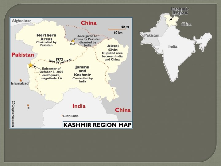
Conflict In Kashmir 1947 – Creation of the two countries Secular, mostly Hindu India Muslim nation of Pakistan Conflict between Hindus and Muslims in Kashmir dates back to British rule before partition. India and Pakistan are technically still waiting for a UN decision on where the final border between the two countries will be. Civil war has erupted repeatedly and sporadic fighting continues along the boundary line. Both India and Pakistan have nuclear weapons.