Regional Geography of the Western Pacific BI 201

Regional Geography of the Western Pacific BI 201 Natural History of Guam Class Presentation 03

n Most of the geographic features of the western Pacific are submarine, with little emergent land Map of the Pacific Ocean floor, showing principal trenches, ridges, and basins.

n There are three major geographic features of the region: • submarine ridges n n Submarine ridges generally are long, elevated areas that may rise 100 s to 1000 s m above the sea floor There are two general types 1) submarine ridges without emergent islands are more common 2) submarine ridges with emergent islands are less common

• submarine trenches Trenches are elongated depressions of the ocean floor n They tend to be parallel to volcanic island chains (i. e. , island arcs) or continental margins n Trenches are very small in area, typically only 50– 100 km wide, but they may be thousands of kilometers long n Trenches are the deepest areas of the ocean; up to 11 km deep n

• oceanic basins Basins include the ocean floor in those parts of the ocean floor that are >2000 m deep n Basins occupy the greatest area of the geographic features of the western Pacific n Basins account for ca. 75% of the Pacific Ocean floor n

n Andesite Line • The most significant regional distinction in the Pacific is the andesite line n The andesite line separates the deeper, basic igneous rock [i. e. , formed by the cooling of magma or lava] of the Central Pacific Basin from the partially submerged continental areas of acidic igneous rock on its margins


• The andesite line is the boundary between the Pacific Ocean and the continental land masses n n It circumscribes the Pacific Ocean It follows the western edge of the islands off California and passes south of the Aleutian arc, along the eastern edge of the Kamchatka Peninsula, the Kuril Islands, Japan, the Mariana Islands, the Solomon Islands, and New Zealand It continues northeastward along the western edge of the Albatross Cordillera along South America to Mexico, returning then to the islands off California Indonesia, the Philippines, Japan, New Guinea, and New Zealand—all eastward extensions of the continental blocks of Australia and Asia—lie outside the Andesite Line

• The andesite line forms the structural boundary between the Pacific Ocean and the Philippine Sea A series of trenches and ridges links the Japan Trench down to the Yap Trench n Within the closed loop of the andesite line are most of the deep troughs, submerged volcanic mountains, and oceanic volcanic islands that characterize the Central Pacific Basin n

• The andesite line also forms a petrographic boundary, i. e. , rock boundary The sea floor is composed primarily of andesitic basalt in the Philippine Sea n The sea floor is composed primarily of olivine basalt in Pacific Ocean n

• The andesite line is also an active volcano zone n n n This volcanism is associated with island building Outside the andesite line, volcanism is of the explosive type, and the so-called Pacific ring of fire is the world’s foremost belt of explosive volcanism Within the central Pacific basin, basaltic lavas gently flow out of rifts to build huge dome-shaped volcanic mountains whose eroded summits form island arcs, chains, and clusters

• The andesite line is also an active seismic zone, i. e. , a zone of earthquakes n Earthquakes of both deep (30– 700 km) and shallow (<30 km) focus are common along the andesite line • N. B. : only shallow earthquakes are associated with the mid-ocean ridges

n Geography of the Mariana Archipelago • The Mariana Islands consist of two island arcs
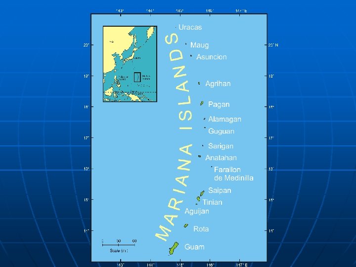

• southern Mariana Islands: n = 6 n general characteristics: • all are inactive volcanoes; there has been no volcanism since the Miocene (5 Mybp) • their volcanic age is much older than the northern arc n the oldest rocks in the southern islands are 42 – 43 Mybp, with a range of 9 – 43 Mybp • all are capped with emergent limestone n therefore, all have been submerged in the geological past • they are offset toward Pacific Ocean
 n n n Guam: area")
• southern arc islands (with area and elevation) n n n Guam: area = 637 km 2; highest elevation = Mt. Lamlam @ 404 m Rota: 85. 2 km 2; highest elevation = Mt. Sabana @ 491 m Agiguan: area = 7. 2 km 2; highest elevation = 168 m Tinian: area = 101. 7 km 2; highest elevation = 178 m Saipan: area = 120. 6 km 2; highest elevation = Mt. Tagpochau @ 765 m Farallon de Medinilla: = 0. 9 km 2; highest elevation = 81 m

• northern Mariana Islands: n = 9 n general characteristics: • all are active volcanoes, including submergent ones; i. e. , all have erupted within the last 1, 000 yr their volcanism is very young (<1. 4 Mybp) n there is no uplifted limestone capping the islands n they are offset towards the Philippine Sea [offset is 22 – 35 km] n
 Anatahan: area = 32. 3")
• northern arc islands (with area and elevation) Anatahan: area = 32. 3 km 2; highest elevation = 788 m n Sarigan: area = 5. 0 km 2; highest elevation = 549 m n Zealandia Bank: two emergent rocks ca. 0. 8 km apart; highest elevation = 0. 8 m n Guguan: area = 4. 2 km 2; highest elevation = 301 m n Alamagan: area = 11. 2 km 2; highest elevation = 744 m n

Pagan: area = 47. 7 km 2; highest elevation = 569. 9 m n Agrihan: area = 44. 0 km 2; highest elevation = 965 m n Asuncion: area = 7. 3 km 2; highest elevation = 891 m n Maug: consists of three islets: North Island = 227 m, East Island = 215 m, West Island = 178 m n Farallon de Pajaros [a. k. a. Uracus]: area = 2. 04 km 2; highest elevation = 334 m n

n You can visit the northern islands, virtually, online at the Volcano World web site: http: //volcano. und. nodak. edu/vwdocs/volc_i mages/southeast_asia/mariana/basic_geolo gy. html
- Slides: 20