Randleman Lake A Regional Partnership Piedmont Triad Regional

 – 12, 000")
 1986 PTRWA formed under NC Chapter 162 A")
 l 1987 USACE abandoned as active project upon")


 – 102 feet above streambed –")


- Slides: 28
Randleman Lake – A Regional Partnership Piedmont Triad Regional Water Authority
Project History l 1937 - US Army Corps of Engineers (USACE) – 12, 000 acres – flood control & recreation l 1968 - USACE – project authorized by Congress
Piedmont Triad Regional Water Authority (PTRWA) 1986 PTRWA formed under NC Chapter 162 A to facilitate water supply arrangements of project l Six (6) Member Governments –Cities of Archdale, Greensboro, High Point, Randleman, Town of Jamestown, & Randolph County l Seats on Board of Directors determined by percent ownership in the Authority l
Piedmont Triad Regional Water Authority (PTRWA) l 1987 USACE abandoned as active project upon determination that cost of project would outweigh the flood control benefits l 1987 PTRWA Member Governments entered into Interlocal Agreement to pursue as solely a water supply project
Randleman Lake Interlocal Agreement l Ultimate Water Allocation - Based on % Ownership - l Greensboro – 25. 5 MGD High Point – 9. 1 MGD Randolph County – 8. 75 MGD Archdale – 2. 45 MGD Jamestown – 1. 2 MGD Randleman – 1. 0 MGD Interbasin Transfer - 28. 5 MGD to Haw River Basin – 2. 0 MGD to Yadkin River Basin
Randleman Lake Project l 6000 acre project – 3, 000 acre reservoir – 3, 000 acre conservation buffer l Over 100 miles of protected shoreline
Permitting History l l l Permitting process for reservoir took over 10 years – multiple lawsuits 1991 - State Environmental Impact Statement, Interbasin Transfer Permit, Eminent Domain 1997 - Draft Federal Environmental Impact Statement, Request for reclassification as water supply 1998/1999 – Critical Water Supply (WS-IV)/Randleman Rules Declaration, Section 401 Water Quality Certification 2000 – Final Federal Environmental Impact Statement 2001 – USACE 404 d Permit issued
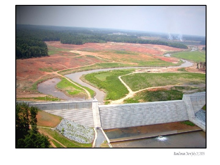
Aug. 7, 2001 – Dam Groundbreaking
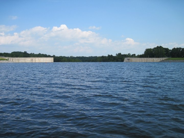
Dam Construction l Methodology – Roller-Compacted Concrete (RCC) – 102 feet above streambed – 2, 090 feet in length (1, 000 feet RCC section) – Ogee spillway – no ability to store and release
Reservoir Filling l Dam construction completed in 2003 l Staged filling of reservoir began in August 2005 l Reservoir completely filled by summer 2007
Other Project Components l Roads and Bridges – 25 total projects – realignment, closures, new construction
Other Project Components Roads and Bridges l Wetland Mitigation – 600 acres Cypress Swamp – Nature Conservancy – 121 acres restoration/ creation (5 sites) l Reservoir Clearing l
Other Project Components l l l Roads and Bridges Wetland Mitigation Reservoir Clearing Transmission Lines High Point Eastside Discharge Relocation
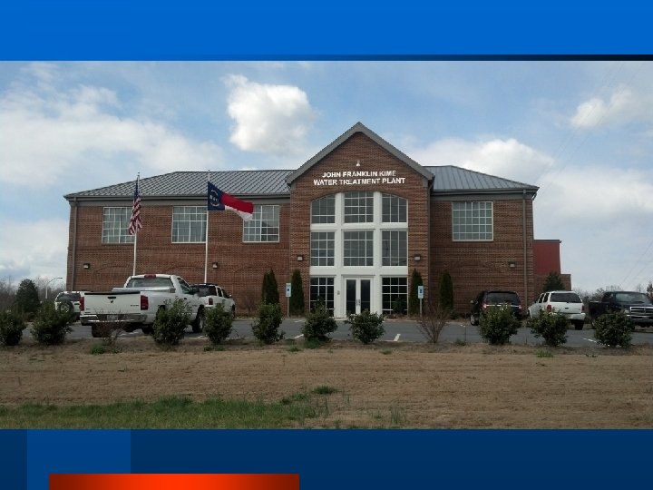
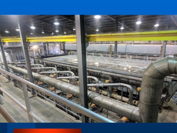
Water Treatment Plant l Initially Sized for 12 MGD – Expandable to 48 MGD – Current production capacity of 14. 7 MGD – Future expansions will be based on partners’ needs l State of the Art Filtration Technology – triple barriers of protection – concerns about High Point’s Eastside WWTP & Seaboard Chemical Site – Awarded State AWOP Certification in 2015, 2016 & 2017 l Solely a water wholesaler – No retail customers l Onsite Certified Laboratory – routine water quality sampling – contract testing
Recreation l Randleman Lake Marina – boating and pier fishing only recreational uses allowed – Southwest Park – electric and self-propelled boats only – Approaching 20, 000 visitors per year l Marina is a 100% self-funded operation l Marina is open March through November – Monday & Tuesday closed – available for Special Events – Operation North State Fishing Festival l Gaining recognition as one of the best lakes in the region for large mouth bass and crappie fishing
Buffer & Lake Management l 2006 received law enforcement authority to regulate activities on PTRWA property l 1 Full-time and 5 Part-time lake wardens – Enforce protection of no impact buffer zone (ATV’s, bank fishing, hunting, encroachment) – Regulate fishing activities at marina and on the lake – Oversee security for all PTRWA property and facilities – Manage aquatic weeds and native aquatic plant reintroduction program in cooperation with the State
On-going Lake Management l Regulating Buffer Encroachment – conducting on-going surveillance program l Stormwater Education and Pollution Prevention – Educating citizens and businesses on stormwater issues – Partner in Keep Randolph Beautiful – awarded Source Water Protection Award in 2017 l Buffer Reforestation Project – targeted planting around reservoir to enhance natural progression l Emergency response to pollution incidents
Credit – Floyd Austin
Credit – Floyd Austin
Credit – Floyd Austin
Long Range Planning l The Authority works to meet the needs of all the members individually and cooperatively while ensuring the strength and vitality of the organization and all the partners as a whole – Establish Capital Improvement Plan and funding for long term renewal and replacement of the system – Plan for future expansions that allow for the most flexibility in capacity while balancing potential future regulatory requirements – Manage the health and viability of the reservoir while meeting downstream flow requirements and planning for increased withdrawals
Cooperation and Planning l Establish a Drought Contingency Plan that balances the needs of all the partners with each individual system’s interdependencies while maintaining permit and contractual requirements l Piedmont Water Supply Partners Meetings Communication – Quarterly meeting amongst all interconnected water systems in the region – Began as coordination meetings for converting all primary interconnected systems to chloramines and has grown into a quarterly technical update for common regulatory concerns, water quality issues and system wide events
Keys to Our Success l Partnership in working to meet the long-term needs of the citizens we all serve l Allowing for flexibility within the master agreement to meet the evolving needs of the partners l Planning from a regional perspective while accounting for the individual needs of each of our partners
Contact Information l PTRWA • • • Gregory Flory, PE Executive Director gflory@ptrwa. org (336) 498 -5510 www. ptrwa. org