RANCHI MOBILITY FOR ALL Shreya Gadepalli Regional Director

RANCHI MOBILITY FOR ALL Shreya Gadepalli Regional Director

PROMOTING SUSTAINABLE AND EQUITABLE TRANSPORTATION WORLDWIDE

Promoting sustainable and equitable transportation worldwide Trans. Milenio in Bogota, Columbia

OUR PROGRAMME AREAS 1. Developing modern, attractive mass rapid transport systems 2. Creating safer walking and cycling environment 3. Encouraging pedestrian and transit-oriented planning 4. Reducing congestion through parking management 5. Drafting policies to promote sustainable mobility 6. Training and communication on best practices Janmarg, Ahmedabad

2 decades in India Delhi Ahmedabad Ranchi Nashik Pune Coimbatore Chennai

Ranchi Transport Study

RANCHI KAISE CHALTI HAI? 12 SURVEYS 0 0 0 11, PE T N I OPLE D E W E I V ER

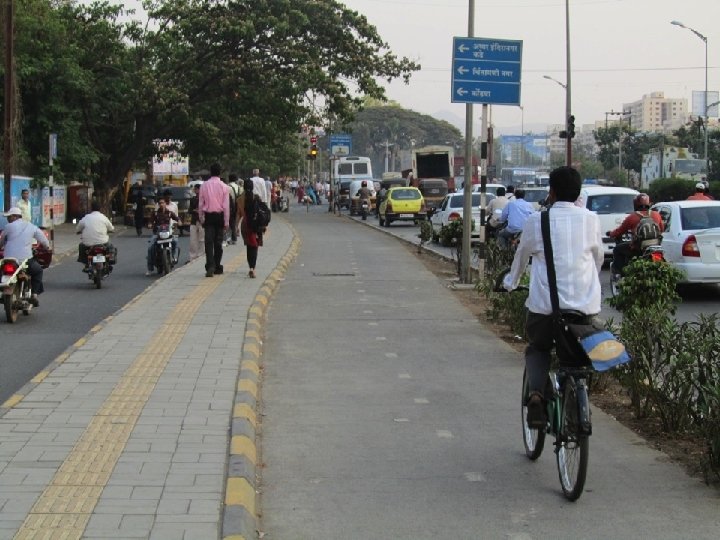
37% people on foot BUT NO FOOTPATHS

33% trips on public transport BUT NO PUBLIC TRANSPORT

WOMEN 90% USE Share autos or walk

Cars & Motorcycles 21% TRIPS 99% budget

CYCLISTS 60% MORE THAN CAR USERS

How Ranchi residents travel

Modes vs. Gender
 61% 91 %")
M F Feel unsafe on share auto (late in the evening) 61% 91 % Consider moving from share auto to two wheeler 32% 9% Consider cycling in place of share auto 12% 1% Cyclists who find lonely roads to be a problem 26% Cyclists who are teased 0% 59 % 46 %

The alternatives before Ranchi In status quo, • Personal motor vehicle trips will quadruple. • Pollution will increase. Street fatalities will increase. • Movement will come to a standstill.

KEY RECOMMENDATOINS…

1. Footpaths and safe street crossings: Walking is the most fundamental mode of mobility. Everybody except the physically weaker or handicapped people can walk. Wheelchair accessible footpaths can satisfy mobility needs of such people to a large extent. 2. Cycling facilities: Cycles provide pollution free and healthy mobility. They are the most energy efficient mode of transport. They are accessible to people of all ages, including children, and are a key means of transport for the economically weaker sections. 3. Public transportation: If accessible, it addresses mobility needs of physically handicapped also. Free or subsidized travel can address mobility of poor people. 4. Intermediate public transport: Taxis, auto-rickshaws & cycle rickshaws fulfill important needs of a city’s transport system by providing point to point mobility when needed urgently. They also provide last mile connectivity for public transport trips, extending the catchment area of public transport service.

Peak hour trips by walk and cycle WALK CYCLE

Footpaths and safe street crossings: What we have

Footpaths and safe street crossings: What we need

Roads that need footpaths Name of the road Description Length in kms NH- 75 Birsa Chowk - NIFFT Chowk - Ring Road 8. 5 Tatisilwai to Khelgaon 8. 0 Circular Road Jail More - Lalpur 1. 5 NH-23 Lalpur - Booty More 5. 5 Ghutuwa Rd – Kathal Chowk - Piska More 8. 0 Kantoli to Ormanjhi 18. 0 Chutia – Namkum Road Ranchi - Purulia Road to IINRG Campus 3. 1 Ring Road Kanke to Kamre 10. 0 Ranchi-Purulia Road Namkum Railway Station - Tatisilwai - Angara 16. 0 Chutia Main Road Bahu Bazar to Chutia Namkum Road 4. 0 Bariatu Road Kanke Road - Governor House - Booty More 8. 0 Paramahansa Yogananda Path Bahu Bazar Chowk – Kantatoli Chowk – Kokar Chowk 3. 5 Tata Road IINRG Campus - Rampur 7. 0 Kanke Road Ratu Road – Kanke Chowk 6. 5

Roads that need footpaths Name of the road Description Length in kms Argora Dugdugia Toli – Argora Chowk - Ashok Nagar Main Road 5. 0 Cart Sarai Road, Lalji Hirji Road NH-75 to Main Road 1. 5 Church Road Main Road to Bahu Bazar Road 1. 5 Club Road Main Road to Paramahansa Yogananda Path 1. 0 St Francis School Road Lala Lajpat Rai School - St Francis School - NH-75 2. 5 Junction of Ring Road – Kathal Chowk – Argora Chowk 7. 0 NH-23 Piska More – Kutchery Chowk - Jail More 3. 5 Line Tank Road Jail More – Karamtoli Chowk 1. 0 Radium Road ---- 0. 5 Main Road Kutchery Chowk - Albert Ekka Chowk – Birsa Chowk 7. 5

Roads that need footpaths Name of the road Description Length in kms NH-23 and Circular Road Firayalal - Lalpur - Dangratoli 2. 0 Purulia Road Between Main Road and Dangratoli 2. 0 NH-33 Dangratoli - Kantatoli - Namkum Railway Station 4. 5 Total 159. 1
 Residential zone 1. 8 m + 1. 5 m Commercial zone")
Footpaths Standards (IRC) Residential zone 1. 8 m + 1. 5 m Commercial zone 2. 5 m + 2. 5 m High-intensity commercial zone 4. 0 m + 2. 5 m

Frontage zone Pedestrian zone Furniture zone Chennai

FRONTAGE ZONE PEDESTRIAN ZONE FURNITURE ZONE

Street design elements Traffic lane Parking Off street public parking Pedestrian zone Organised vending Cycle track

A complete street…. . NMT Lane A street that provides separate spaces for walking and cycling, and, dedicated lanes for public transport.

Cycling facilities: Proposed network of cycle tracks

Proposed cycle tracks Name of the road Description Length in kms NH-75 Birsa Chowk - NIFFT Chowk - Ring Road 8. 0 Tatisilwai to Khelgaon 8. 0 Lala Lajpat Rai School - St Francis School - NH-75 2. 5 Junction of Ring Road – Kathal Chowk – Argora Chowk 7. 0 NH-23 Ghutuwa Rd – Kathal Chowk - Piska More 8. 0 Chutia - Namkum Road Ranchi - Purulia Road to IINRG Campus 3. 0 Kanke Road Kanke to Ratu Road junction 8. 5 NH-23 Kantatoli to Ormanjhi 18. 0 Ranchi-Purulia Road Namkum Railway Station - Tatisilwai - Angara 16. 0 Chutia Main Road Bahu Bazar to Chutia Namkum Road 4. 0 Tata Road IINRG Campus - Rampur 7. 0 Ring Road Kanke to Kamre 10. 0 St Francis School Road TOTAL 100

8% on cycle

Cycle tracks should be continuous and shaded with a minimum clear width of 2 m Shaded and continuous lane Buffer zone Concrete 2 m wide cycle track Delhi

Green ways Open spaces and canals developed as NMT corridors Long-distance commuting as well as recreational uses.

Need for effective parking management

Managing Parking, especially in high demand areas, should be regulated and charged • Parking fee should reflect the cost of the land it occupies. • On-street parking should be more expensive than off-street parking. • Parking fee payment and enforcement should be electronic to control wrong-parking and revenue leakage. Footpath with on-street parking
")
Albert Ekka Chowk (junction improvements)

Harmu River Greenway
")
Greenways (Contd. )
")
Bada Talaab (Lakefront / Public Spaces)

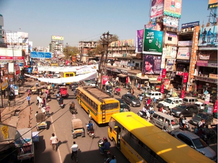
Public transport now

Public transport now

“Build Metro with Buses!!!” Public transport of the future

Public transportation: What we need Multi-modal integration Short, direct walking paths for transferring passengers, Minimal level differences, Adequate clear space to prevent bottlenecks, Protection from sun and rain, Public information

Interface like Metro/LRT | Safe | Fast Step-less entry into bus| Accessible for all

High quality stations | Real-time information Smart fare collection at stations | Dependable

High quality public transport for everyone, not just for those with lower incomes.

Metro-Bus System üHigh quality üHigh speed üHigh capacity A modern transport system for SMART CITIES, not an old bus running in a bus lane!

Can we just expand the roads? Existing conditions 3 -lane carriageway Status quo scenario 2 lanes + elevated road Cost: ₹ 60 -100 cr. /km Capacity: 1. 5 times > Even if all main roads have elevated corridors on top, they will be full in five years!

A better alternative Existing conditions 3 -lane carriageway Sustainable scenario 2 -lanes + 1 lane metro-bus Cost: ₹ 15 cr. /km Capacity: 10 times > BRT can accommodate not only 2023 demand but also take care of future growth for many decades

Buses carry more across the world

What will ₹ 1, 000 crore accomplish? Underground metro: 2. 5 km Elevated metro: 5. 0 km Monorail: 6. 7 km BRT: 67 km

Commercial speeds BRT system Metro rail

Metrobus on streets

Monorails occupy more space than Metrobus

Developing a high quality public transport system in Ranchi can reduce congestion and pollution The public transport network in 2 tiers: • One tier offering rapid, very high quality and reliable mobility, i. e. a Mass Rapid Transit (MRT) system, • Second tier providing feeders to and extensions of the first tier

Ranchi BRT system Phase 1: • Ratu Road from Piska More to Kutchery Chowk • Main Road from Kutchery Chowk to Dhurva • NH-75 from Ratu Road to Birsa Chowk • Purulia Road from Firayalal to Namkum Railway Station Phase 2: • • • Kanke Road from Pahad colony to Reliance Market Hazaribagh Road from Main Road to Kabristan Nagri Road from Piska More to Lalghutuwa Pathiyatola Road from Jail More to Beda Chowk Lodhma Road from Doranda to J. M. Chowk

Main Road Metrobus

4, 500 Cr. 5% of trips Infra Walking and Cycling Bus and BRT Rs. Cr. 700 1050 Others 50 TOTAL 1800 85% of trips 1, 800 Cr.

Next steps… • Establish an SPV: Creating an empowered urban transport implementing agency is a key step toward ensuring rapid and effective implementation of public transport and other initiatives. • Begin on-street parking management and enforcement: A robust on-street parking management system will support NMT improvements and public transport operations by ensuring that carriageways, footpaths, and cycle tracks remain free of encroachment by parked vehicles and providing critical funding for sustainable transport initiatives. • Seek funding for DPRs: Government of Jharkhand/RMC should initiate the process of preparing DPRs for specific projects and identifying funding sources.
- Slides: 62