
RAMOTSWA PROJECT Hydrogeology report Yvan Altchenko IWMI 2
- Slides: 28
RAMOTSWA PROJECT Hydrogeology report Yvan Altchenko IWMI 2 nd Regional Meeting on Tools for the Sustainable Management of Transboundary Aquifers 28 November – 02 December, Johannesburg, South Africa
Presentation outline • • Objectives Methodology Geology Hydrogeology • • Aquifer description Aquifer properties Flow direction Aquifer dynamics • Groundwater quality • Conclusion and Recommendations
Hydrogeology report - Objectives • This report covers the hydrogeological assessment of the Ramotswa Transboundary Aquifer Area (RTBAA) located around the international border, which covers a small part of Botswana and South Africa in the Limpopo River Basin • It is a status of knowledge based on existing data and collected data during the project • It is a complementary report to the baseline report • It presents: § the climatic conditions § the surface and sub-surface geology § the hydrogeological characteristics • It is linked with the GRECHLIM project (Groundwater Recharge in the Limpopo Basin)
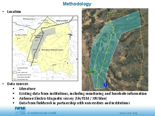
Methodology • Location • Data sources § Literature § Existing data from institutions, including monitoring and borehole information § Airborne Electro-Magnetic survey (Sky. TEM / XRI blue) § Data from fieldwork in partnership with universities and institutions
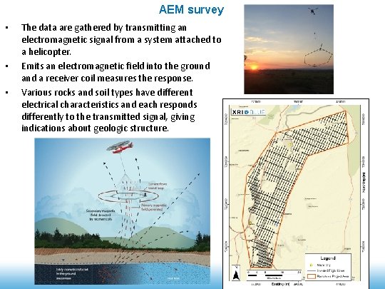
AEM survey • • • The data are gathered by transmitting an electromagnetic signal from a system attached to a helicopter. Emits an electromagnetic field into the ground a receiver coil measures the response. Various rocks and soil types have different electrical characteristics and each responds differently to the transmitted signal, giving indications about geologic structure.
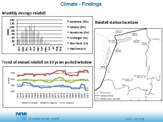
Climate - Findings 140 120 100 80 60 40 20 0 Gaborone (BW) Lobatse (BW) Ramotswa (BW) Witkleigat (SA) Boschrand (SA) Oct Nov Dec Jan Feb Mar Apr May Jun Jul Aug Sep (mm) Monthly average rainfall Madikwe(SA) Trend of annual rainfall on 10 years period window 500 300 1931 1934 1937 1940 1943 1946 1949 1952 1955 1958 1961 1964 1967 1970 1973 1976 1979 1982 1985 1988 1991 1994 1997 2000 2003 (mm) 700 m. min 10 m. max 10 m. av 10 Rainfall station locations
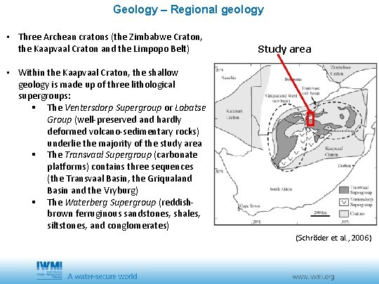
Geology – Regional geology • Three Archean cratons (the Zimbabwe Craton, the Kaapvaal Craton and the Limpopo Belt) Study area • Within the Kaapvaal Craton, the shallow geology is made up of three lithological supergroups: § The Ventersdorp Supergroup or Lobatse Group (well-preserved and hardly deformed volcano-sedimentary rocks) underlie the majority of the study area § The Transvaal Supergroup (carbonate platforms) contains three sequences (the Transvaal Basin, the Griqualand Basin and the Vryburg) § The Waterberg Supergroup (reddishbrown ferruginous sandstones, shales, siltstones, and conglomerates) (Schröder et al. , 2006)
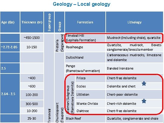
~2. 72 -2. 05 Thickness (m) ~450 -1500 10 -150 Pretoria Group (Segwagwa) Age (Ga) Supergroup Geology – Local geology Formation Lithology Timeball Hill (Lephala Formation) Mudrock (including shale), quartzite Rooihoogte Quartzite, mudrock, Bevets conglomerate/breccia member Duitschland Carbonaceous mudrocks, limestone and dolomite 2. 5 Penge (Ramotswa Formation) Banded ironstone ~600 100 -200 10 -200 25 -30 Transvaal 300 -500 Chuniespoort (Taupone) 2. 64 - 2. 5 Malmani Subgroup (Ramotswa Dolomite) ~400 Frisco Chert-free dolomite Eccles Dolomite and chert Littleton Chert-poor dolomite Monte Christo Chert-rich dolomite Oaktree Chert-free dolomite Black Reef Quartzite, conglomerate and shale
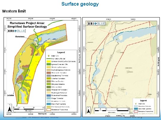
Surface geology Western limit
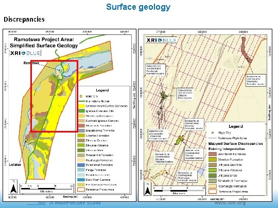
Surface geology Discrepancies
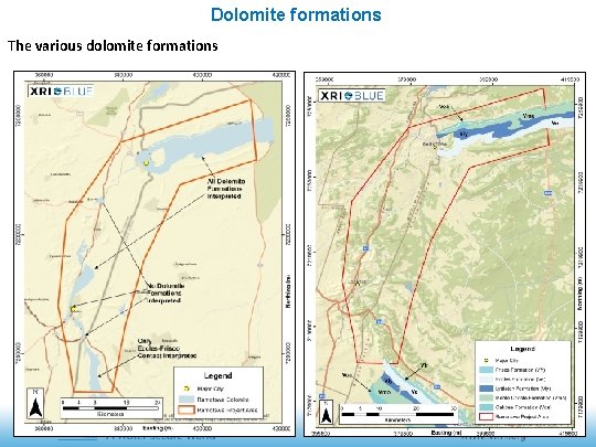
Dolomite formations The various dolomite formations
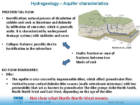
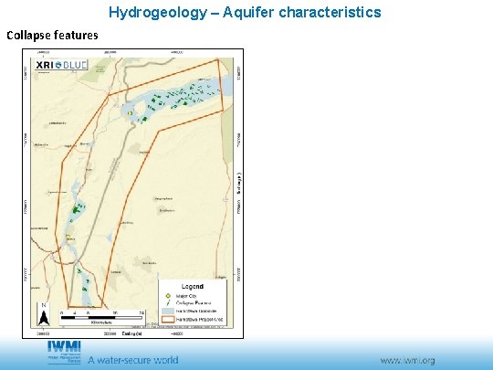
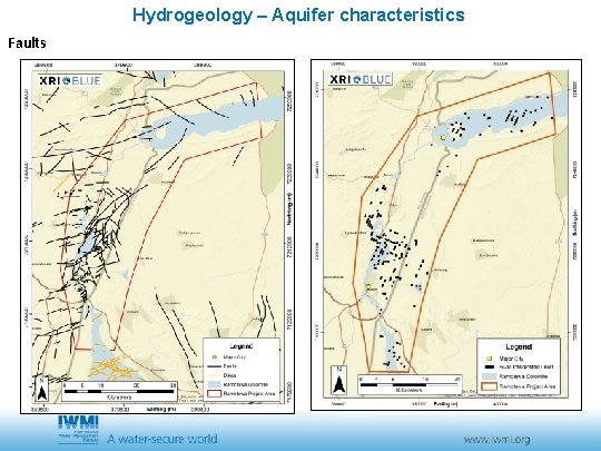
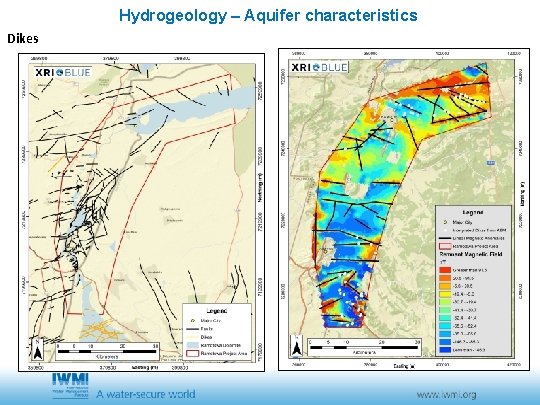
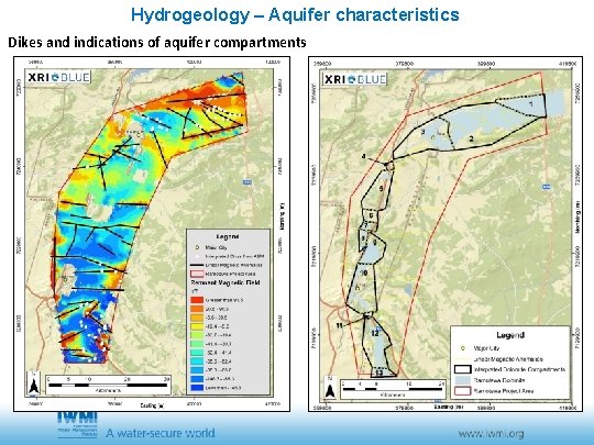
Hydrogeology – Aquifer characteristics PREFERENTIAL FLOW • Karstification: natural process of dissolution of soluble rock such as limestone and dolomite by infiltration of rainwater, which is generally acidic. It is characterized by underground drainage systems with sinkholes and caves • Collapse features: possibly due to karstification in the subsurface Runkel et al. , 2003 • Faults: fracture or zone of fractures between two blocks of rock NO-FLOW BOUNDARIES • Dike: § The aquifer is criss-crossed by impermeable dikes, which affect groundwater flow. § Vertical to near vertical dolerite dike swarms (mafic subvolcanic intrusions) with low permeability that act as barriers to groundwater The dike groups strike North-South, North-West and East-West, depending on the age of the dike. Not clear what North-West means.
Hydrogeology – Aquifer characteristics Collapse features
Hydrogeology – Aquifer characteristics Faults
Hydrogeology – Aquifer characteristics Dikes
Hydrogeology – Aquifer characteristics Dikes and indications of aquifer compartments
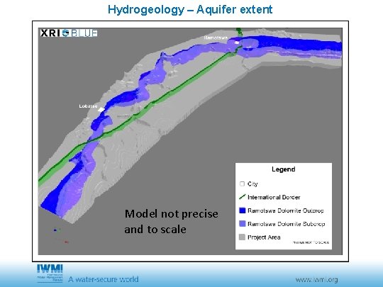
Hydrogeology – Aquifer extent Model not precise and to scale
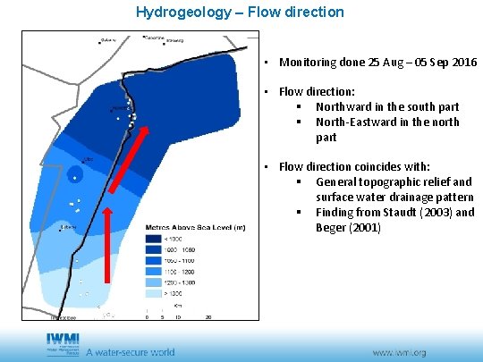
Hydrogeology – Flow direction • Monitoring done 25 Aug – 05 Sep 2016 • Flow direction: § Northward in the south part § North-Eastward in the north part • Flow direction coincides with: § General topographic relief and surface water drainage pattern § Finding from Staudt (2003) and Beger (2001)
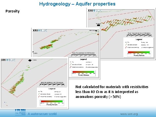
Hydrogeology – Aquifer properties Porosity Not calculated for materials with resistivities less than 40 Ω-m as it is interpreted as anomalous porosity (> 50%)
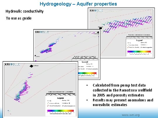
Hydrogeology – Aquifer properties Hydraulic conductivity To use as guide • • Calculated from pump test data collected in the Ramotswa wellfield in 2005 and porosity estimates Results may present anomalous and unrealistic estimates
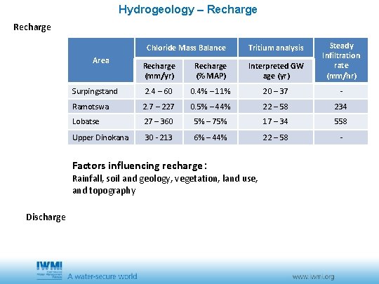
Hydrogeology – Recharge (mm/yr) Recharge (% MAP) Interpreted GW age (yr) Steady Infiltration rate (mm/hr) Surpingstand 2. 4 – 60 0. 4% – 11% 20 – 37 - Ramotswa 2. 7 – 227 0. 5% – 44% 22 – 58 234 Lobatse 27 – 360 5% – 75% 17 – 34 558 Upper Dinokana 30 - 213 6% – 44% 22 – 58 - Chloride Mass Balance Area Factors influencing recharge: Tritium analysis Rainfall, soil and geology, vegetation, land use, and topography Discharge
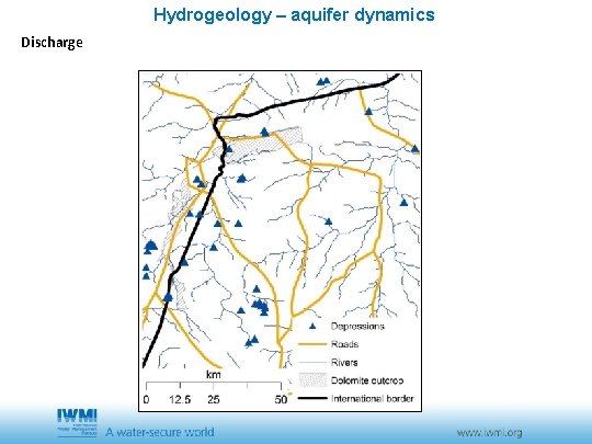
Hydrogeology – aquifer dynamics Discharge
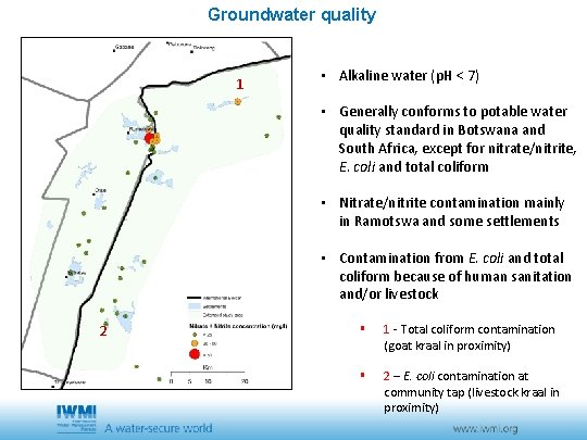
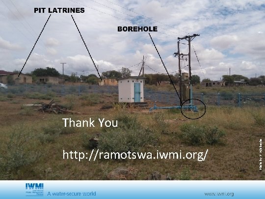
Groundwater quality 1 • Alkaline water (p. H < 7) • Generally conforms to potable water quality standard in Botswana and South Africa, except for nitrate/nitrite, E. coli and total coliform • Nitrate/nitrite contamination mainly in Ramotswa and some settlements • Contamination from E. coli and total coliform because of human sanitation and/or livestock 2 § 1 - Total coliform contamination (goat kraal in proximity) § 2 – E. coli contamination at community tap (livestock kraal in proximity)
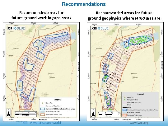
Recommendations Recommended areas for future ground work in gaps areas Recommended areas for future ground geophysics where structures are
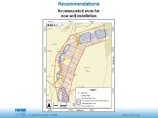
Recommendations Recommended areas for new well installation
Conclusions • There are two aquifers in the study area (the Lephala Aquifer and the Ramotswa Dolomite) but the geology is complex. Ramotswa the most extensive and important • The Ramotswa Dolomite corresponds to five dolomite formations referred to as either “chert-free” (poor aquifer) or “chert-rich” (main water-bearing aquifer) but the five formation were not always identified by AEM • Dikes create barriers and sometimes compartments within the Ramotswa Dolomite • Groundwater is contaminated with nitrate/nitrite, E. coli and coliforms from human activities (pit latrines, livestock) BUT there is need to: • Better constrain the aquifer characteristics (porosity, hydraulic conductivity, storativity, yield) • Better understand the recharge and discharge mechanisms and areas • Understand the rainfall-groundwater-river interactions (floods) • Implement long-term groundwater monitoring (water level, water quality)
References • Altchenko, Y. , Lefore, N. , Villholth, K. G. , Ebrahim, G. , Genco, A. , Pierce, K. , Woolf, R. , Mosetlhi, B. B. T. , Moyo, T. , Kenabatho, P. , and Nijsten, G. (2016). Resilience in the Limpopo basin: the potential role of the transboundary Ramotswa aquifer. Baseline report. 15 June 2016. • Beger, K. 2001. Environmental Hydrogeology of Lobatse; South East District, Rebublic of Botswana: Department of Geological Survey, Environmental Geology Division. • IGRAC (2015) Tranboundary aquifers of the World -Special Edition for the 7 World Water Forum http: //www. unigrac. org, • Runkel, A. C. , Tipping, R. G. , Alexander, E. C. , Jr. , Green, J. A. , Mossler, J. H. and Alexander, S. C. (2003) Hydrogeology of the Paleozoic bedrock in southeastern Minnesota: Minnesota Geological Survey, Report of Investigations 61, 105 p. , 1 map in pocket. • Schröder, S. ; Lacassie, J. P. ; Beukes, N. J. 2006. Stratigraphic and geochemical framework of the Agouron drill cores, Transvaal Supergroup (Neoarchean–Paleoproterozoic, South Africa). South African Journal of Geology, June, 109: 23 -54 • Staudt, M. 2003. Environmental hydrogeology of Ramotswa; South East District, Republic of Botswana, s. l. : Department of Geological Survey. Botswana: Environmental Geology Division. • UNESCO/ISARM (2001). Internationally Shared (Transboundary) Aquifer Resources Management – Their significance and sustainable management. A framework document, IHP-VI, Series on Groundwater No 1. • http: //ramotswa. iwmi. org/ • RIMS: https: //ggis. un-igrac. org/ggis-viewer/ramotswa/public/default
http: //ramotswa. iwmi. org/ Photo by Y. ALtchenko Thank You