R 1 R 9 Review In the Back

R 1 -R 9 Review In the Back of your Book!!! • MAP PROJECTIONS

THE LAW OF MAPS • You cannot unfold a GLOBE equally!!! • There will always be some degree of distortion!!! • Types of Distortion: Shape , Size (Area), Distance, or Direction

For each of the following Map Projections consider… 1. What does this map look like? 2. Why is this Map type useful or valuable? 3. Why is this Map distorted or flawed?
?")
Mercator Projection • What country is located at the Prime Meridian? (90 longitude)?

Robinson Projection

Fuller/Dymaxion Projection

Azimuthal Projection

Contour Lines

DOT MAP

Isoline Map

Choropleth Map

Choropleth Map

Cartogram Map

World Map of Political Borders

Cartogram Map – World Population • Borders/Area distorted to show data
 • Borders/Area distorted to show data")
Cartogram Map • Transforms Space (of political unit) • Borders/Area distorted to show data • Greatest value for some type of data becomes largest mass of area

Cartogram Map • Challenge

Cartogram Article Cartogram Project www. worldmapper. org

What is scale? • ratio between distances portrayed on a map and actual distances on the earth's surface • Large Scale- Map that presents smaller space (Ex. City Map) • Small Scale- Map that presents larger space (Ex. World Map)

Map Overview A map which transforms the bordered physical space of any country into space reflecting some data element, distorting the physical borders is called a this kind of a map. • a) a cognitive map • b) a Mercator projection • c) a cartogram • d) an isoline map • e) a treasure map
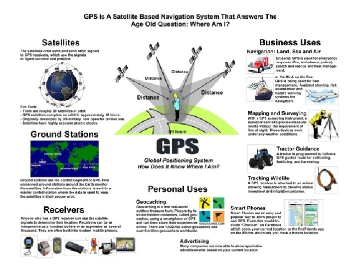
 • Global Positioning System (GPS)")
• Geographic Information Systems (GIS) • Global Positioning System (GPS)

Geographic Information Systems- A system designed to capture, store, manipulate, analyze, manage, and present all types of geographically referenced data in layers

Park Safety for Children

• Food Desert GIS: http: //www. usccr. gov/pubs/IL-Food. Deserts -2011. pdf

Remote Sensing • Remote Sensing technology used to create maps, without having to physically touch the territory being described. • Often deployed from a plane or satellite. • Can be used to help develop and inform GPS
- Slides: 26