QABATIA STORM WATER SEWER SYSTEM Jamal Nazzal Diaa

QABATIA STORM WATER SEWER SYSTEM - Jamal Nazzal - Diaa Tamimi - Ahmad Amarni

PROJECT OBJECTIVES • understand the problem of Qabatia rainfall-runoff process. And • Improve the current stormwater routing structures. By • Using Storm. CAD software to design and expand the current network.

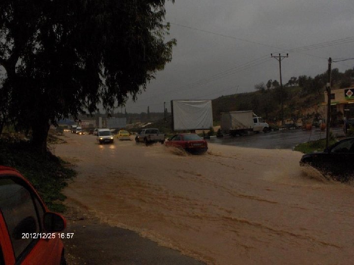
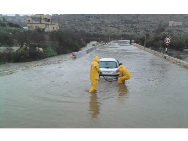
GENERAL DESCRIPTION OF QABATIA • Located 9 kilometers south-west of Jenin. • 300 meters above sea level. • Its area is 6000 donums. • A valley surrounded by mountains. • Around 30000 capita occupy the area of Qabatia.

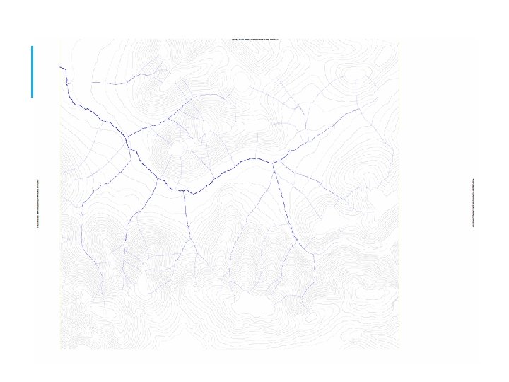
CATCHMENT AREA • A catchment can be defined as the total area of land that drains to a particular point along a stream. • Water flows perpendicular to contour lines in the direction of the slope. • Flow paths, and divides were drawn. • Main flow paths were determined. • Civil 3 D was used.
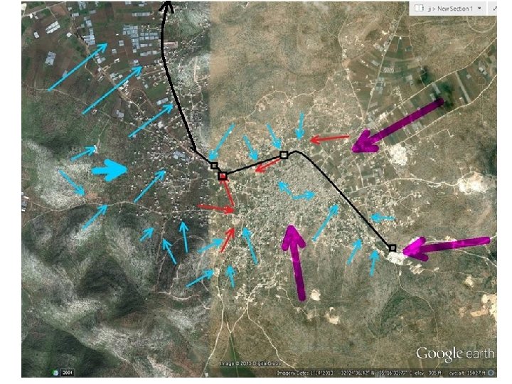

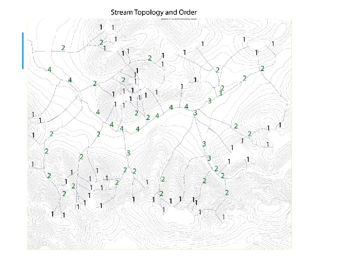
STREAM TOPOLOGY AND ORDER Stream topology and order helps the designer understand predict the locations and dimensions of various hydraulic structures.

THE IDF CURVES Using the measurements from short duration rainfall, a series of rainfall curves (IDF curves) are prepared for practical use in engineering work. Different stations are Located, and are given weight with respect to that area.

THE IDF DATA FOR NABLUS CITY, USED FOR QABATIA

Annual Rainfall Hyetograph 700 600 500 400 300 200 100 0 1 1996 1997 1998 1999 2000 2001 2002 2003 2004 2005 2006 2007 2008 2009 2010 2011 2012

THEORY AND METHODS OF COMPUTATION §Manning’s Equation §Darcy-Weisbach Equation §Hazen-Williams Equations §The Rational Method § § Morgali and Linsley Method Kirpich Method Kerby-Hatheway Method The Federal Aviation Administration equation §Shreve

THE RATIONAL METHOD

BASIC ASSUMPTIONS OF THE RATIONAL METHOD • The max. runoff rate at any location is a function of the average rainfall rate during the time of concentration for that location. • The max. rainfall rate occurs during the time of concentration.

RUNOFF COEFFICIENT C Type of surface Concrete, asphalt, solid rock Gravel Farmland, parks Woodland C 0, 8 -0, 9 0, 4 -0, 6 0, 2 -0, 4 0, 1 -0, 2

TIME OF CONCENTRATION T C • The flow time from the most remote point in the drainage area to the point in question. • Usually is equal to an overland flow time plus a channel flow time. • channel flow time estimation = channel length / avg. full-flow velocity

METHODS FOR COMPUTING THE OVERLAND TC • Morgali and Linsley Method • Kirpich Method • Kerby-Hatheway Method • The Federal Aviation Administration equation

MORGALI AND LINSLEY METHOD 1965

NOTES ON MORGALI’S The Morgali and Linsley equation is implicit in that it cannot be solved for tc without i. So, iteration is required. Solution can be achieved by combining Morgali’s with the intensity equation Then solving using a numerical method (such as a calculator solver). The solution of the two equations yields both tc and i.

KIRPICH METHOD 1940

KERBY-HATHEWAY METHOD 1959

A COMBINATION • Overland flow rarely occurs for distances exceeding 1200 feet. • So, if the watershed length exceeds 1200 feet, then a combination of Kerby’s equation (Overland Flow) and the Kirpich equation (channel tc) may be appropriate. • Values for Kerby’s roughness parameter N are presented on the following table

THE FEDERAL AVIATION ADMINISTRATION EQUATIONS 1965

TIME OF CONCENTRATION T C It is recommended that tc be less than 300 minutes and greater than 10 minutes The concept is that estimates of i become unacceptably large for durations less than 5 or 10 minutes For long durations (such as longer than 300 minutes), the assumption of a relatively steady rainfall rate is less valid.

STREAM ORDER

OPEN CHANNEL FLOW AND ENERGY LOSSES EQUATIONS • Manning’s equation • Darcy-Weisbach equation • Hazen-Williams equation

MANNING’S EQUATION • Gravity full flow occurs at that condition where the conduit is flowing full, but not yet under any pressure • Analysis of open-channel flow in a closed conduit is no different than any other type of open-channel flow. • In gravity flow conditions, manning's discharge formula is applicable for the discharge of pipes and culverts. • Q is Discharge • n is Manning’s coefficient • A is the cross-sectional area • R is the hydraulic radius • S is the slope of the pipe

• Due to the additional wetted perimeter and increased friction that occurs in a gravity full pipe, a partially full pipe carries greater flow. • For a circular conduit the peak flow occurs at 93 percent of the height of the pipe, and the average velocity flowing one-half full is the same as gravity full flow.

DARCY-WEISBACH EQUATION

MOODY DIAGRAM

HAZEN-WILLIAMS EQUATION V=CHR 0. 63 S 0. 54 CH= the hazen-willliams coefficient


: Part full. Flow from higher to lower")
ASSUMPTIONS 1 - Gravity flow (manning’s eqn): Part full. Flow from higher to lower elevation.

ASSUMPTIONS 2 - Rational Method for surface discharge: Q=Ci. A Rainfall is uniform along the entire catchment area. Rainfall intensity is constant. The discharge rate assumes that every point in the catchment contributes to the outfall.

ASSUMPTIONS 3 - Time of concentration: Method used: FAA equation Convert tc from hrs to mins

ASSUMPTIONS 4 - Surface flow: All streets are surrounded by high-curb sidewalks Water doesn’t cross from streets to land or vice-versa All surface discharge enters the catch basin at the lowest point
 Circular Minimum diameter =")
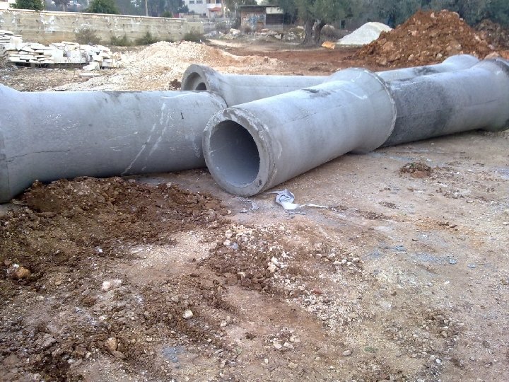
DEFINITION OF NETWORK ELEMENTS 1 - Pipes: Concrete (n=0. 013) Circular Minimum diameter = 16” (400 mm)

DEFINITION OF NETWORK ELEMENTS 2 - Catch basins: Location: in sag Desired sump depth = 2 m Clogging factor = 20% Shape: sqaure Structural width = 0. 9 m Grate width = 0. 8 m

DEFINITION OF NETWORK ELEMENTS 3 - Manholes: Diameter = 36” Serves as a point of intersection of two or more pipes Where there’s change in alignment or slope

DEFINITION OF NETWORK ELEMENTS 4 - Catchment areas: Drawn using the positions of catch basins C values were determined for each catchment Tc values were determined using FAA method For urban areas increase Tc<5 to 5

DEFINITION OF NETWORK ELEMENTS 5 - IDF Data The data used was for a return period= 5 years

DEFINITION OF NETWORK ELEMENTS 6 - street-crossing culverts Shape: box Material : concrete (n=0. 013) Depth = 30 cm Width range: [30 cm-180 cm]

NETWORK LAYOUT CONSIDERATIONS Loops are prohibited; only 1 downstream pipe On street paths, directed to open channel Catch basins are appointed where there’s water accumulation

NETWORK LAYOUT CONSIDERATIONS Street-crossing culverts are assigned to allow flow streams to cross the street section and reach the nearest catch basin Or wherever its uneconomical to appoint a catch basin and connect it to the network
![DESIGN CONSTRAINTS Velocity: Pipes: [0. 6 – 6] m/s Culverts: [0. 6 – 8]](http://slidetodoc.com/presentation_image_h/11f7a53d01f8ecf666000d175acdd178/image-48.jpg "DESIGN CONSTRAINTS Velocity: Pipes: [0. 6 – 6] m/s Culverts: [0. 6 – 8]")
DESIGN CONSTRAINTS Velocity: Pipes: [0. 6 – 6] m/s Culverts: [0. 6 – 8] m/s Slope = [1 – 10] % While 0. 5% is allowable Cover: [0. 8 – 5] m Water depth: Pipes: 75% Street culverts: 50%


RESULTED ERRORS 1 - Cover exceeded: Change pipe paths 2 - Velocity exceeded: Use drop manholes

RESULTED ERRORS Drop manholes profile
")
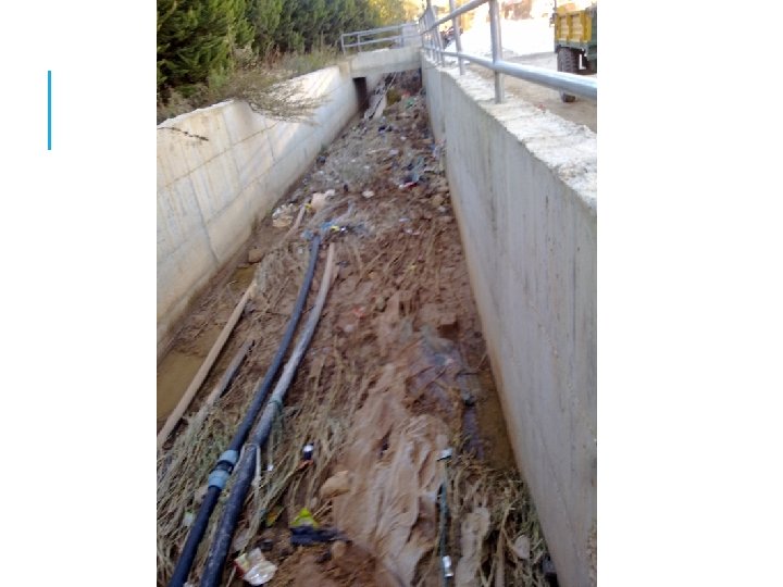
RESULTED ERRORS 3 - Main open channel (impractical depth)

RESULTED ERRORS Profile for that section

RESULTED ERRORS Alternative path; box conduit in land

RESULTS Layout
 – Existing channel depth")
RESULTS Excavation = (GL – Invert elevation according to profiles) – Existing channel depth
![RESULTS 1 - Conduits: Diameter range: [400 mm-2250 mm] Velocity:](http://slidetodoc.com/presentation_image_h/11f7a53d01f8ecf666000d175acdd178/image-57.jpg "RESULTS 1 - Conduits: Diameter range: [400 mm-2250 mm] Velocity:")
RESULTS 1 - Conduits: Diameter range: [400 mm-2250 mm] Velocity:

RESULTS Cover: Slope
![RESULTS 2 - Street-crossing culverts Thickness = 30 cm Span range: [30 – 180]](http://slidetodoc.com/presentation_image_h/11f7a53d01f8ecf666000d175acdd178/image-59.jpg "RESULTS 2 - Street-crossing culverts Thickness = 30 cm Span range: [30 – 180]")
RESULTS 2 - Street-crossing culverts Thickness = 30 cm Span range: [30 – 180] cm Velocity

RESULTS Slope High slopes are acceptable since velocities are within range, and there aren’t any links that could be damaged

RESULTS 3 - Catchments surface discharge

RESULTS 4 - Outfall discharge Q= 44. 49 m 3/s Less than sum of catchments discharge because of the accumulation of Tc with pipe lengths

RECOMMENDATIONS Covering the open channel but leaving openings for maintenance and to preserve open flow conditions. Opening manhole covers in case of a storm event of a return period>5 to allow streams to reach the next catch basin.

RECOMMENDATIONS Use of bars at the opening of a street culvert in addition to a depression at the opening to retain large solids. Use of reinforced concrete around street culverts’ parameters. Use of anchors or rings around steep-slope culverts

THANK YOU
- Slides: 70