Principles of Remote Sensing Digital Image Processing Image


 • Computer software v")


 certain frequencies and pass (emphasize) others. Ø Filters")

 is applied to imagery")

- Slides: 23
Principles of Remote Sensing Digital Image Processing
Image Restoration and Image Processing • • The scope of digital image processing Digital images Image processing systems Image restoration Image Enhancement Image Classification Image data-set merging and fusion 1/8/2022 ESR 421 Principles of Remote Sensing 2
The scope of digital image processing • • What is a Digital Image? Image restoration (pre-processing) Image enhancement Image classification (information extraction) • Data-set merging and image fusion 1/8/2022 ESR 421 Principles of Remote Sensing 3
What Is A Digital Image? It is a rectangular array of horizontal lines. Each line is made of picture elements called pixels. Each pixel has a digital number called DN value. The DN value represents the EM energy that was sensed by a sensor in a certain spectral band (range) from an area (ground spatial resolution cell) on the earths surface. Lines Pixel What your computer sees… What you see… 70 53 41 64 84 85 81 88 91 87 79 77 45 38 59 77 84 86 85 85 80 82 69 44 32 45 72 86 82 78 88 79 86 87 65 40 41 75 79 78 93 86 93 106 84 56 43 58 75 104 100 101 95 91 83 51 39 56 105 110 97 88 84 85 87 77 59 44 96 103 89 79 79 75 77 79 74 72 87 93 97 90 82 76 70 67 61 71 79 81 88 97 93 85 78 74 70 72 81 75 78 85 94 97 92 84 80 72 • Digital numbers (DNs) typically range from 0 to 255; 0 to 511; 0 to 1023, 1023 etc. • These ranges are binary scales: 28=256; 29=512; 210=1024.
What Is A Digital Image? 70 53 41 64 84 85 81 88 91 ba nd 87 Lines or rows (y) 70 77 53 41 64 84 85 81 88 91 87 79 45 38 59 77 84 86 85 85 70 53 41 64 84 85 81 88 91 87 79 77 45 38 59 77 84 86 85 85 80 82 69 44 32 45 72 86 82 78 70 53 41 64 84 85 81 88 91 87 79 77 45 38 59 77 84 86 85 85 91 80 82 6970 4453 3241 4564 7284 8685 8281 7888 88 79 86 87 65 40 41 75 79 78 79 77 45 38 59 77 84 86 85 85 70 53 41 64 84 85 81 88 80 82 69 44 32 45 72 86 82 78 85 88 79 8679 8777 6545 4038 4159 7577 7984 7886 93 106 84 56 43 58 75 80 82 69 44 32 45 72 86 82 78 79 77 45 38 59 77 84 86 88 79 86 87 65 40 41 75 79 78 82 106 69 82 93 86 9380 106 8444 5632 4345 5872 7586 104 100 101 95 91 83 51 39 56 88 79 86 87 65 40 41 75 79 78 80 106 82 106 69 44 32 45 72 86 93 84 56 43 58 75 88 101 79 79 104 100 9586 9187 8365 5140 3941 5675 105 110 97 88 84 85 87 77 59 44 93 86 93 106 84 56 43 58 75 88 101 79 86 87 65 40 41 75 104 100 95 91 83 51 39 56 106 87 106 7784 58 105 110 9793 8886 8493 85 5956 4443 96 103 89 79 79 75 77 79 74 72 104 100 101 95 91 83 51 39 56 93 86 93 106 87 106 77 84 56 43 105 110 97 88 84 85 59 44 104 79 100 75 101 7795 39 96 103 89 7991 7483 7251 87 93 97 90 82 76 70 67 61 71 105 110 97 88 84 85 87 77 59 44 104 79 100 75 101 77 95 91 83 51 96 103 89 79 74 72 105 90 110 8297 59 87 93 97 7688 7084 6785 6187 7177 79 81 88 97 93 85 78 74 70 72 96 103 89 79 79 75 77 79 74 72 105 90 110 82 97 88 84 85 87 77 87 93 97 76 70 67 61 71 103 9389 74 79 81 8896 97 8579 7879 7475 7077 7279 81 75 78 85 94 97 92 84 80 72 87 93 97 90 82 76 70 67 61 71 96 103 93 89 79 79 75 77 79 79 81 88 97 85 78 74 70 72 61 81 75 7887 8593 9497 9790 9282 8476 8070 7267 79 81 88 97 93 85 78 74 70 72 87 93 97 90 82 76 70 67 81 75 78 85 94 97 92 84 80 72 79 81 88 97 93 85 78 74 70 81 75 78 85 94 97 92 84 80 72 79 81 88 97 93 85 78 74 81 75 78 85 94 97 92 84 80 81 75 78 85 94 columns (x) (Pixles) 97 92 84 s( 87 91 85 87 85 78 85 82 78 78 79 75 78 58 56 75 39 44 56 59 72 44 74 71 72 61 72 71 70 72 72 80 72 z)
Greyscale vs. RGB Greyscale is typically used to display a single band… RGB (“Red”, “Green”, “Blue”) images can display 3 bands, corresponding to the Red, Red Green and Blue phosphors on a monitor. Computer monitor colors are additive red + green + blue = colors. + + =
BLUE TM-Band 1 GREEN TM-Band 2 TCC 3 R 2 G 1 B RED TM-Band 3
IR Band 4 GREEN Band 2 FCC 4 R 3 G 2 B RED Band 3
Image processing systems requirements • Computer hardware (e. g. PC) • Computer software v Operating system (e. g. Windows/NT) v Image processing software (e. g. ERDAS) • Operator (e. g. you) 1/8/2022 ESR 421 Principles of Remote Sensing 9
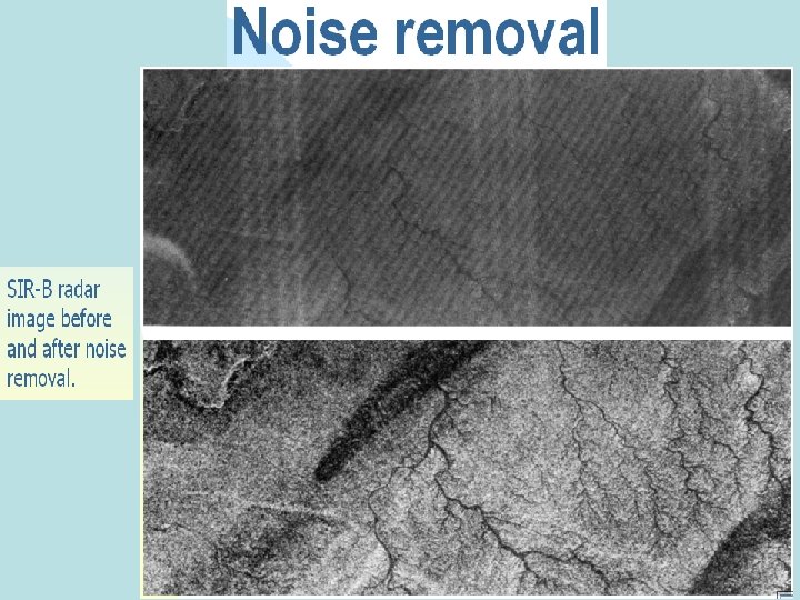
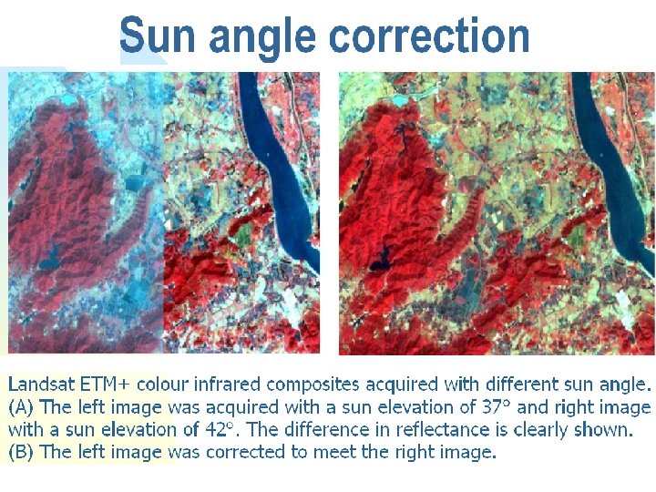
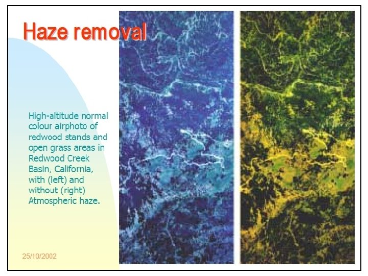
Image restoration • Types of errors and distracting effects in digital images: v Geometric distortions v Noise patters • • • Detector Response error Stripping Salt and pepper v Variations in solar illumination angle v Atmospheric haze. 1/8/2022 ESR 421 Principles of Remote Sensing 10
Radiometric corrections • Noise correction v Electronic noise – both random and periodic • Sun-angle correction v For comparison and mosaic images acquired from different time of the year • Correction for atmospheric scattering v Subtract the haze DN values from different bands DN 1/8/2022 ESR 421 Principles of Remote Sensing 11
Effects of seasonal change on solar elevation angle. (The solar zenith angle is equal to 90 o minus the solar elevation angle)
Image Enhancement • Is the process of making an image more interpretable for a particular application q Radiometric Enhancement q Spatial Enhancement q Spectral Enhancement 1/8/2022 ESR 421 Principles of Remote Sensing 16
Radiometric Enhancement • Enhancing images based on the values of individual pixels q Contrast Stretch q Haze Reduction 1/8/2022 ESR 421 Principles of Remote Sensing 17
Spatial Enhancement • Enhancing images based on the values of individual and neighboring pixels. q Convolution (moving window) q Image Filtering q Low-pass filters q High-pass filters 1/8/2022 ESR 421 Principles of Remote Sensing 18
Spectral Enhancement • Enhancing images by transforming the values of each pixel on a multi -band basis. q Ratioing (Indices) q PCA (Principal Component Analysis) q Decorrolation Stretch 1/8/2022 ESR 421 Principles of Remote Sensing 19
Spatial Filtering Filter: they suppress (de-emphasize) certain frequencies and pass (emphasize) others. Ø Filters that pass high frequencies, and hence emphasize fine detail and edges, are referred to as high-frequency filters. Ø Low-frequency filters suppress the highfrequency content of the imagery while emphasizing gradual changes. 1/8/2022 ESR 421 Principles of Remote Sensing 20
Smoothing Low-Frequency filtering in the spatial domain image enhancement that de-emphasize or block the high spatial frequency detail are low-frequency or low-pass filters (LPF) INPUT Kernel 3 x 3 5 x 5 7 x 7 1/8/2022 Image OUTPUT New brightness value that is the mean of this convolution ESR 421 Principles of Remote Sensing 21
Sharpening High-frequency filtering in the spatial domain. High-pass filtering (HPF) is applied to imagery to remove the slowly varying components and retain only the highfrequency local variations (multiplication & sum) 1/8/2022 ESR 421 Principles of Remote Sensing 22
Edge Enhancement Geologist map faults, joints, lineaments, etc… Geogrpahers map man-made linear features, highways, what the eyes see as pictorial edges are simply sharp changes in brightness value between two adjacent pixels. 1/8/2022 ESR 421 Principles of Remote Sensing 23