PRESERVATION and PROGRESS IN THE DRAGON RUN ZONING

 includes: a. Tidal wetlands;")


 Boundary Definition The boundary between the DRC and other")
 Permitted Uses 1. The construction and maintenance of non-commercial")


- Slides: 21
PRESERVATION and PROGRESS IN THE DRAGON RUN ZONING FRAMEWORK PARADIGM DESIGN APRIL 26, 2005 Work Session
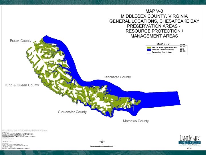
CHESAPEAKE BAY PROTECTION ORDINANCES 1. The Resource Protection Area (RPA) includes: a. Tidal wetlands; b. Non-tidal wetlands connected by surface flow and contiguous to tidal wetlands or water bodies with perennial flow; c. Tidal shores; and d. A vegetated buffer area not less than 100 feet in width located adjacent to and landward of the components listed in subsections a. through c. above, and along both sides of any water body with perennial flow. 2. The Resource Management Area (RMA) includes: a. The 100 year floodplain; b. Non-tidal wetlands not connected by surface flow and contiguous to tidal wetlands, water bodies with perennial flow or other tidal waters; c. Highly erodible and highly permeable soils; d. Slopes in excess of fifteen (15) percent; and e. Where none of the above features exist, the RMA will be one hundred fifty (150) foot linear distance from the landward side of the RPA. Source: Middlesex County Zoning Ordinance, 2004
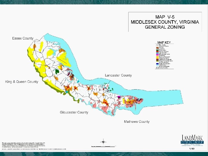
CHESAPEAKE BAY PROTECTION ORDINANCES COUNTY DEFINITION of RPA DEFINITION of RMA Essex 100 ft buffer from designated environmentally sensitive areas All Areas of the County outside the RPA Gloucester 100 ft buffer from designated environmentally sensitive areas All areas of the County outside the RPA 100 ft buffer from designated environmentally sensitive areas A minimum of 250 distance ft. landward of the RPA and any areas of highly permeable, erodible and/or hydric soils (outside the RPA) 100 ft buffer from designated environmentally sensitive areas A minimum of 150 distance ft. landward of the RPA and any areas of 100 -year floodplain, highly permeable and erodible soils, slopes greater than 15% and nontidal wetlands connected to tidal wetlands, tributary streams or tidal waters (outside the RPA) King & Queen Middlesex
DRAGON RUN CONSERVATION DISTRICT (DRCD) Boundary Definition The boundary between the DRC and other zoning districts shown on the Official Zoning Map shall consist, for the purpose of this ordinance, of those areas of Kinston-Bibb Complex and Pocaty soils adjacent to the boundary line between Middlesex County and the county or counties of Gloucester, King and Queen, and Essex, plus an additional 100 foot buffer strip measured horizontally from the inland most boundary of these soil types. However, when there is a rise in elevation of 10 feet or greater within 50 feet (horizontally measured) from the edge of Kinston-Bibb Complex and Pocaty soils, then the 100 foot buffer strip shall be measured from the highest point of elevation within said 50 feet.
DRAGON RUN CONSERVATION DISTRICT (DRCD) Permitted Uses 1. The construction and maintenance of non-commercial catwalks, piers, fences, and duckblinds, provided that such structures are so constructed on pilings as to permit the reasonably unobstructed flow of the tidal areas, or natural flow in nontidal areas, and to preserve the natural contour of marshes, swamps and water courses. 2. The cultivation and harvesting of shellfish and worms for bait. 3. Non-commercial outdoor recreational activities, including hiking, boating, trapping, hunting, fishing, shellfishing, horseback riding, swimming, and skeet and trap shooting; provided that no structure shall be constructed except as permitted in subscription (1) of this section. 4. Conservation, repletion, education, and research activities of the Virginia Marine Resources Commission, the Virginia Institute of Marine Science, the Commission of Game and Inland Fisheries, and other related conservation agencies. 5. The normal maintenance, repair, or addition to existing roads, highways, or the facilities of any person, firm, corporation, utility, or government abutting on or crossing wetlands or swamps, provided that no waterway is altered and no additional wetlands or swamps are covered or drained. 6. Governmental activity on wetlands or swamps owned or leased by the Commonwealth of Virginia or by Middlesex County. 7. The normal maintenance of existing man-made drainage ditches, provided that no additional wetlands or swamps are covered or drained and provided further that this paragraph shall not be deemed to authorize construction of any new drainage ditch. 8. Agricultural management activities must incorporate the application of Best Management Practices (BMPs) in a plan approved by the local Soil and Water Conservation District. 9. Forestry management activities must incorporate the application of Best Management Practices in a plan approved by the Virginia Department of Forestry.
DRCD
OPTIONAL ZONING APPROACHES Land Use-Based Provisions Advantages of Land Use-Based Provisions: · Widespread benefits to water quality, wildlife habitat and natural resource conservation are generally considered to derive from maintaining a pattern of low intensity uses and low population densities in an area. · Rural areas with low intensity uses have a tendency to maintain a tradition of large parcels and stable ownership patterns, which limits fragmentation of the landscape into smaller separate tracts, and thus can result in more extensive undisturbed corridors and patches that aid significantly in wildlife conservation. · Under rural land uses and zoning, there are generally lower pressures for recreational use of waterways and lower potentials for stream degradation (e. g. from littering & dumping) in the general area around streams and sensitive environmental areas.
OPTIONAL ZONING APPROACHES Performance-Based Provisions Advantages Performance-Based Provisions: · Performance-based provisions generally allow more flexibility than land-use based provisions. They are “useneutral” and, consequently, allow a variety of creative solutions to achieve a landowner’s needs while meeting the provisions of a performance-based code. · Performance-based provisions are often more effective in directly addressing the causes of pollution and stream degradation. To the extent that environmental threats can be pinpointed in an area, performance standards can target only those practices, such as septic disposal systems or construction and grading, that directly affect stream quality.
OPTIONAL ZONING APPROACHES A. EXTEND AND SIMPLIFY THE DRCD · Change the way that the Dragon Run Conservation District is defined, from a definition based on soils and elevations, to a simple distance of 300 feet from the main stream course of the Dragon Run. · Expand the Purpose and intent of the district to include considerations for water quality, erosion control, overall habitat conservation and protection of rare species. · Link the purpose of the ordinance to the implementation of policies in the new Dragon Run Compatible Economic Development and Preservation Model District in the County Comprehensive Plan
OPTIONAL ZONING APPROACHES B. UPGRADE THE DRCD TO INCLUDE PERFORMANCE STANDARDS · Add performance standards to the DRCD to supplement the land use provisions. · Because of the comprehensiveness and complexity of the Chesapeake Bay standards that are already in place, refrain from adding another layer of new standards for the DRCD – instead, simply extend the provisions of the Chesapeake Bay RPA to the new 300 -foot DRCD buffer. · Variations on this approach include minor refinements to the Chesapeake Bay provisions, such as requiring BMP’s for all forestry practices in the entire 300 foot buffer and for all farming practices (still subject to the 75 foot and 50 foot encroachment provisions as in the Chesapeake Bay requirements), or extending the RMA in the County to a wider area (not relevant in Gloucester or Essex Counties).
OPTIONAL ZONING APPROACHES C. ESTABLISH A WATERSHED-WIDE OVERLAY DITSRICT THAT ADDRESSES BASIC LAND USES · Create a new overlay zone for the watershed that would modify, but not completely replace the schedule of permitted use provisions in the underlying zoning districts. · Include a land use table in the new zone that would redefine permitted and permissible uses (permitted uses are those that are permitted “by right” - permissible uses are those that are permitted by Special Use or Special Exception). · In general, this table would include almost all the existing uses in the current underlying county zoning districts. However, it would eliminate some extremely intense uses, such as auto graveyards and landfills, and it would put a larger category of more intense uses, such as commercial and industrial uses, in the “permissible” category.
OPTIONAL ZONING APPROACHES D. ESTABLISH A WATERSHED-WIDE OVERLAY DISTRICT THAT ADDRESSES RESIDENTIAL DENISTIES · Incorporate residential density provisions into the new zoning overlay district. The counties in the watershed currently have zoned residential densities in the area ranging from 1 to 5 acre lots. However, the subdivision regulations in each county limit development to a handful of lots (as minor subdivisions) on a tract, without rezoning to a higher district. · In order to provide consistency between the intent of the subdivision and zoning provisions and the comprehensive plan in each county, revise the base residential density in the overlay zone to very low densities, such as one unit per 20 or 25 acres. · A refinement to this approach would be “sliding-scale” zoning, which would allow more density on smaller parcels and less density on larger parcels. · A further refinement would be to have mandatory open space provisions that would require a percentage (usually 50%-85%) of newly developed lots to be protected as open space by a conservation easement.
RECOMMENDED APPROACH to apply an overlay zone that covers the entire watershed, requires only minor changes to existing standards at the watershed scale, while extending the streamside protection provisions of the DRCD and the CBPO to a simplified buffer from the main stream course.
RECOMMENDED APPROACH Watershed-Wide provisions: · Provide a land use table that defines permitted uses, conditional use and prohibited uses. This table would mostly reinforce the existing permitted uses in the base agricultural zoning districts of the counties, but would make most more intensive uses conditional on a special use permit. It would also eliminate a few very intense uses. · Provide a residential density table that would establish an overall base density in the watershed of 1 unit per 25 acres. Exceptions would be made for family subdivisions and parcels smaller than 25 acres and the zone would not change the subdivision provisions for major and minor subdivisions in each county.
RECOMMENDED APPROACH Streamside Provisions · Within the new overlay district, establish a new streamside buffer zone that supercedes the DRCD with a simple 300 -foot buffer zone from the main stream channel of the Dragon Run. The new buffer zone would include the same list of permitted uses as the current DRCD. · The buffer zone provisions would also automatically extend the Chesapeake Bay RPA standards to apply within the whole 300 -foot buffer. This would provide a greater level of protection, especially for wildlife habitat and rare species without adding a new layer of administrative and enforcement complexity to each county’s codes. · Similar to the Chesapeake Bay provisions, the new buffer zone would also require forestry BMP’s in the entire 300 foot buffer area. It would also require Farming BMP’s, as in the Chesapeake Bay provisions, for encroachments of 50 and 75 feet into the buffer area.
QUESTIONS “Achieve consistency across county boundaries among land use plans and regulations in order to maintain farming and forestry and to preserve natural heritage areas by protecting plants, animals, natural communities, and aquatic systems. ” • What standard(s) should we apply to achieve consistency? • What standards best protect traditional industries? • What standards best protect natural resources? • What is the best framework for a model overlay district?