Presentation Plus Glencoe World Geography Copyright by The

Presentation Plus! Glencoe World Geography Copyright © by The Mc. Graw-Hill Companies, Inc. Developed by FSCreations, Inc. , Cincinnati, Ohio 45202 Send all inquiries to: GLENCOE DIVISION Glencoe/Mc. Graw-Hill 8787 Orion Place Columbus, Ohio 43240

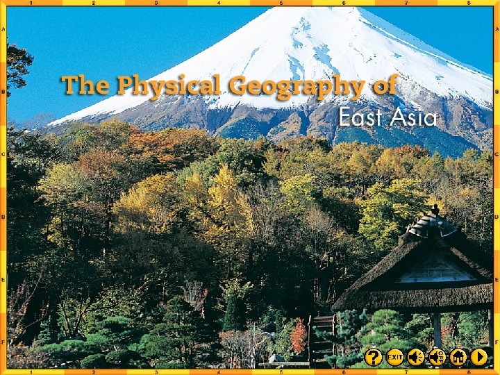
Chapter Introduction Section 1 The Land Section 2 Climate and Vegetation Chapter Summary & Study Guide Chapter Assessment Click on a hyperlink to view the corresponding slides.

Chapter Objectives • Identify East Asia’s varied landforms, water systems, and natural resources. • Explain the factors that influence East Asia’s diverse climates and vegetation. Click the mouse button or press the Space Bar to display the information.

As you read this chapter, use your journal to note the landforms and climate regions of East Asia. Write a series of descriptive paragraphs about these geographic features. Be sure to create a vivid, detailed description of each feature.

The Land Objectives • Describe how East Asia’s landforms are affected by the region’s location on the Ring of Fire. • Compare the landforms of China with those in the rest of East Asia. • List the important natural resources that are present in East Asia. Click the mouse button or press the Space Bar to display the information.

The Land Terms to Know • archipelago • tsunami • loess Click the mouse button or press the Space Bar to display the information.

The Land Places to Locate • Mongolia • Tarim Basin • Hong Kong • Taklimakan Desert • Macau • Gobi • South China Sea • Yellow River (Huang He) • Korean Peninsula • Japan • Pamirs • Himalaya • Plateau of Tibet (Plateau of Xizang) Click the mouse button or press the Space Bar to display the information. • Yangtze River (Chang Jiang) • Xi (West) River

Click the Speaker button to listen to the audio again.

Japan is a chain of more than 3, 000 islands running from Hokkaido in the north to the distant Ryukyu Islands in the south. Four main islands–Honshu, Hokkaido, Shikoku, and Kyushu–account for more than 98 percent of the total land area. At their greatest length from the northeast to southwest, the main islands stretch about 1, 200 mi (1, 900 km) and span 900 miles (1, 500 km) from east to west. Japan has over 18, 000 miles of coastline, but its total size is less than that of California.

Land Sea • China covers about 80 percent of East Asia’s land area and has the world’s largest population–more than 1. 25 billion people. • The rest of East Asia is shared by Japan, Taiwan, North and South Korea, and Mongolia. (pages 645– 647) Click the mouse button or press the Space Bar to display the information.
 • Peninsulas, Islands, and Seas Along the coast of East")
Land Sea (cont. ) • Peninsulas, Islands, and Seas Along the coast of East Asia, many peninsulas and islands dot the westernmost Pacific Ocean. • The South China Sea, stretching from Taiwan to the Philippines and the peninsula of Southeast Asia, carries one -third of the world’s shipping traffic. (pages 645– 647) Click the mouse button or press the Space Bar to display the information.
 • The Ring of Fire The islands of Japan and")
Land Sea (cont. ) • The Ring of Fire The islands of Japan and Taiwan are part of the Pacific Ring of Fire, a circle of volcanoes bordering the Pacific Ocean. • Plate movements there cause frequent, violent earthquakes and volcanic eruptions. • Japan has more than a thousand minor earthquakes every year. (pages 645– 647) Click the mouse button or press the Space Bar to display the information.
 • Japan is also vulnerable to tsunamis generated by underwater")
Land Sea (cont. ) • Japan is also vulnerable to tsunamis generated by underwater earthquakes. • These high tidal waves crash over the land can cause great destruction and loss of life. (pages 645– 647) Click the mouse button or press the Space Bar to display the information.
 (pages 645– 647) Click the Speaker button to listen to")
Land Sea (cont. ) (pages 645– 647) Click the Speaker button to listen to the audio again.
 Given its location on the Ring of Fire, why does")
Land Sea (cont. ) Given its location on the Ring of Fire, why does Japan have such a large population? Japan is a highly developed country that has learned to adapt to the environment. (pages 645– 647) Click the mouse button or press the Space Bar to display the answer.

Mountains, Highlands, and Lowlands Mountain ranges and highlands mark inland regions of East Asia. Lowlands stretch through eastern and coastal areas. (pages 647– 648)
 • East Asian Mountains - From an area")
Mountains, Highlands, and Lowlands (cont. ) • East Asian Mountains - From an area of high peaks known as the Pamirs, the Kunlun Shan and Tian Shan ranges extend across western China. - The Himalaya, the world’s highest mountains, separate China from South Asia. - Japan and Taiwan have mountainous interiors surrounded by coastal plains. - Mount Fuji is a dramatic peak rising above the central plains of Honshu, Japan’s biggest island. (pages 647– 648) Click the mouse button or press the Space Bar to display the information.
 • China’s Plateaus, Basins, and Deserts - The")
Mountains, Highlands, and Lowlands (cont. ) • China’s Plateaus, Basins, and Deserts - The Plateau of Tibet in southwest China is East Asia’s highest plateau region with an elevation of about 15, 000 feet (4, 600 m). - The Mongolian Plateau consists mainly of grassy pastures ideal for grazing. - Broad, flat highlands include the Tarim Basin between China’s far inland mountain ranges; the Taklimakan Desert to its west; and the Gobi, a desert area located in the north. (pages 647– 648) Click the mouse button or press the Space Bar to display the information.
 - The Sichuan Basin, a huge, fertile area")
Mountains, Highlands, and Lowlands (cont. ) - The Sichuan Basin, a huge, fertile area between the Plateau of Tibet and the North China Plain, is one of China’s most important agricultural areas. - It has a mild climate and a long growing season. (pages 647– 648) Click the mouse button or press the Space Bar to display the information.
 Where do most people in the region live?")
Mountains, Highlands, and Lowlands (cont. ) Where do most people in the region live? Why? The Sichuan Basin has a large population because it is fertile farmland. (pages 647– 648) Click the mouse button or press the Space Bar to display the answer.

River Systems • China’s Rivers - China’s major rivers originate high in the Plateau of Tibet and flow eastward to the Pacific Ocean. - The Yellow River, or Huang He, gets its name from the tons of yellowish topsoil blown by winds from the western deserts. - Carried eastward and deposited by the river, this rich soil makes the North China Plain an agriculturally productive area. - Throughout history, flood waters have also killed hundreds of thousands of people. (pages 648– 649) Click the mouse button or press the Space Bar to display the information.
 (pages 648– 649) Click the Speaker button to listen to")
River Systems (cont. ) (pages 648– 649) Click the Speaker button to listen to the audio again.
 - Central China’s Yangtze, or Chang Jiang, is Asia’s longest")
River Systems (cont. ) - Central China’s Yangtze, or Chang Jiang, is Asia’s longest river at 3, 965 miles (6, 380 km). - It flows through gorges and plains and empties into the ocean at Shanghai. - The Xi, or West, River is southern China’s most important river. - It flows into the South China Sea, where it has created a huge, fertile delta. - The Grand Canal–the world’s longest artificial waterway–connects Hangzhou in the south to Beijing in the north. (pages 648– 649) Click the mouse button or press the Space Bar to display the information.
 • Rivers in Japan and Korea have short, swiftly flowing")
River Systems (cont. ) • Rivers in Japan and Korea have short, swiftly flowing rivers with spectacular waterfalls. • These rivers provide hydroelectric power. • North Korea’s Amnok, or Yalu, River forms its border with China. (pages 648– 649) Click the mouse button or press the Space Bar to display the information.
 • The Power of Wind and Water The Chinese concept")
River Systems (cont. ) • The Power of Wind and Water The Chinese concept of feng shui guides architects, contractors, and decorators to design and build structures that harmonize with surrounding landforms. (pages 648– 649)
 Why do the Chinese apply feng shui to architecture? Possible")
River Systems (cont. ) Why do the Chinese apply feng shui to architecture? Possible answer: When buildings fit harmoniously with their settings, the structures are more conductive to human activities, and the occupants gain peace of mind. (pages 648– 649) Click the mouse button or press the Space Bar to display the answer.

Natural Resources • China’s large land area contains the greatest share and widest range of mineral resources, including iron ore, tungsten, tin, and gold. • The Taklimakan Desert has large oil deposits. Northeastern China and the Korean peninsula have an abundance of coal. • Only 10 percent of China’s land is suitable for farming, but China is nonetheless the world’s leading producer of rice. (pages 649– 650) Click the mouse button or press the Space Bar to display the information.
 • South Korea’s prime farmland produces two crops a year")
Natural Resources (cont. ) • South Korea’s prime farmland produces two crops a year of rice and barley. • Mongolia and Japan have very limited farmland poor soil. • In Taiwan, about one-fourth of the land is farmable. • Taiwan’s most important resources are its hardwood forests. (pages 649– 650) Click the mouse button or press the Space Bar to display the information.
 • Japan, South Korea, Taiwan, and coastal China support the")
Natural Resources (cont. ) • Japan, South Korea, Taiwan, and coastal China support the world’s busiest deepsea fishing industries. • Seafood farming also has become a major industry in East Asia. (pages 649– 650) Click the mouse button or press the Space Bar to display the information.
 (pages 649– 650) Click the Speaker button to listen to")
Natural Resources (cont. ) (pages 649– 650) Click the Speaker button to listen to the audio again.
 Given Japan’s limited space and poor soil, how have the")
Natural Resources (cont. ) Given Japan’s limited space and poor soil, how have the Japanese been able to survive? Possible answer: They have made efficient use of limited farmland to grow food. They have depended on the sea for foods such as fish and seaweed. (pages 649– 650) Click the mouse button or press the Space Bar to display the answer.

Checking for Understanding Define Match each definition in the left column with the appropriate term in the right column. __ A 1. a group or chain of islands A. archipelago __ C 2. fine, yellowish-brown topsoil made up of particles of silt and clay, usually carried by the wind B. tsunami __ B 3. Japanese term used for a huge sea wave caused by an undersea earthquake Click the mouse button or press the Space Bar to display the answers. C. loess

Critical Thinking Comparing and Contrasting How are East Asia’s coastal, island, and peninsula areas similar? How do they differ from inland areas? The areas are similar in that they are close to the sea. The are different in that there are no long rivers and less farmland on islands. Click the mouse button or press the Space Bar to display the answer.

Critical Thinking Drawing Conclusions How does the technique of feng shui reflect East Asian beliefs about humans and their environment? Humans are a part of their environment and should be in harmony with it. Click the mouse button or press the Space Bar to display the answer.

Critical Thinking Predicting Consequences What consequences do you think will result from East Asia’s use of its ocean resources? Possible answer: Current practices will result in overfishing or depletion of ocean resources. Click the mouse button or press the Space Bar to display the answer.

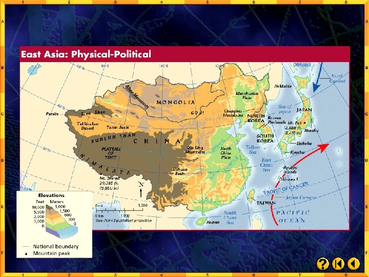
Analyzing Maps Place Study the physical-political map below. How does the elevation of the North China Plain compare with that of the Plateau of Tibet? Click the mouse button or press the Space Bar to display the answer.
 above sea")
Analyzing Maps The North China Plain, at 0 -1000 feet (0300 m) above sea level, is at a much lower elevation than the Plateau of Tibet. This feature is located at 10, 000 feet (3, 000 m) above sea level.

Applying Geography Soil Building Describe the soil-building process that takes place in northern China’s Yellow River basin. How does this process influence the natural environment, the people, and economy of the area?

Close Reread “A Geographic View” on page 645 of your textbook. Write a description of an East Asian land or water feature that intrigues you, as if you were seeing it in person for the first time.

Climate and Vegetation Objectives • State the reasons for East Asia’s wide variety of climates. • Explain how winds, ocean currents, and mountains influence the climates of East Asia. • Identify the conditions that cause the extreme climates in much of China. • List the kinds of natural vegetation that are found in East Asia’s varied climate regions. Click the mouse button or press the Space Bar to display the information.

Climate and Vegetation Terms to Know • monsoon • Japan Current • typhoon Click the mouse button or press the Space Bar to display the information.

Climate and Vegetation Places to Locate • Taiwan • Hainan • Qin Ling Mountains Click the mouse button or press the Space Bar to display the information.

Click the Speaker button to listen to the audio again.

Mongolia is surrounded by land on all sides. It borders Russia to the north and China to the east, south, and west. About 80 percent of Mongolia’s land consists of pastures and meadows. As a result, most Mongolians are engaged in agriculture, primarily as herders. Mongolians grow some wheat and barley, but the mainstay of the economy is raising livestock.

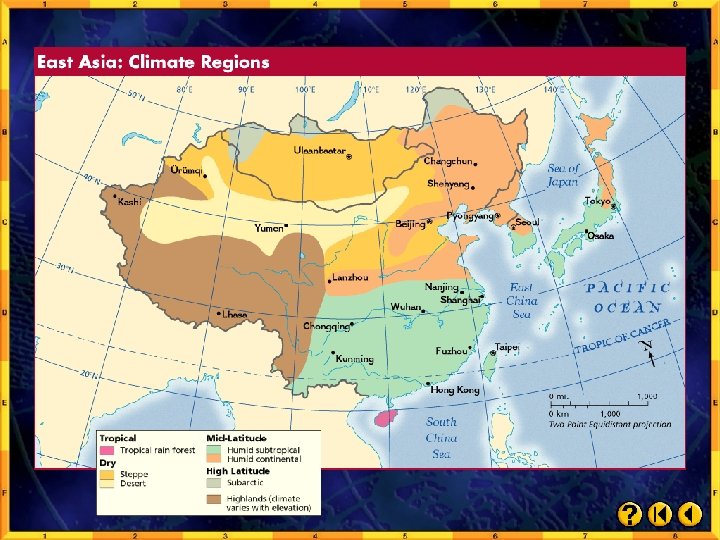
Climate Regions Dry highlands and grasslands dominate East Asia’s north and west, with humid and temperate forests to the south and east. • Mid-Latitude Climates - The southeastern quarter of East Asia has a humid subtropical climate. - Summers are warm, and rains are heavy. - The northeastern quarter has a humid continental climate, with cold, snowy winters. (pages 651– 654)
 - In the eastern half of the region, forests consist")
Climate Regions (cont. ) - In the eastern half of the region, forests consist of evergreen and deciduous trees. - Bamboo grows abundantly in warmer areas and is the only food source for rare mammals, such as giant and red pandas. - People in the region use bamboo in numerous ways, from medicines to material for bridges. - Tea and mulberry leaves also play a major role in the culture and economy of East Asia. (pages 651– 654) Click the mouse button or press the Space Bar to display the information.
 • Desert and Steppe Climates Mongolia and inland northern China")
Climate Regions (cont. ) • Desert and Steppe Climates Mongolia and inland northern China are very dry because the surrounding mountains block the rain. • Gobi and Taklimakan desert areas are often cold and windy. • Temperatures in this climate region vary greatly. (pages 651– 654) Click the mouse button or press the Space Bar to display the information.
 • Highlands Climates The higher the elevation in the mountains,")
Climate Regions (cont. ) • Highlands Climates The higher the elevation in the mountains, the colder the temperature. • The Plateau of Tibet has an average high temperature of only 58ºF (14ºC). • Tropical Rain Forest Climate Hainan, an island off of China’s southern coast, shares a rain forest climate with Taiwan. • The temperatures are always warm, and the summer is very rainy. (pages 651– 654) Click the mouse button or press the Space Bar to display the information.
 • The Roots of Rice and Soy The Chinese have")
Climate Regions (cont. ) • The Roots of Rice and Soy The Chinese have cultivated rice and soybeans for seven thousand years. • These are two of their staple foods. (pages 651– 654) Click the mouse button or press the Space Bar to display the information.
 (pages 651– 654) Click the Speaker button to listen to")
Climate Regions (cont. ) (pages 651– 654) Click the Speaker button to listen to the audio again.

Monsoons • Monsoon winds bring seasonal weather patterns to East Asia. • Summer monsoons blow from southeast to northwest, causing soaking rains from April to October. • Winter monsoons blow in the opposite direction, bringing icy winds from November to March. • Farmers depend on the summer monsoon rains for their crops. (pages 654– 655) Click the mouse button or press the Space Bar to display the information.

Ocean Currents • The warm Japan Current flows northward toward southern Japan, bringing moisture and warm temperatures. • The cold Kuril Current flows southwest from the Bering Sea, bringing cold winds and lower temperatures to Japan’s northern islands. (page 655) Click the mouse button or press the Space Bar to display the information.
 • The interaction of ocean currents and monsoon winds can")
Ocean Currents (cont. ) • The interaction of ocean currents and monsoon winds can give rise to violent typhoons. • Typhoons form in the Pacific Ocean and blow across coastal East Asia. • They tend to be most severe between late August and October. (page 655) Click the mouse button or press the Space Bar to display the information.
 How are monsoons both beneficial and detrimental? Monsoons bring changes")
Ocean Currents (cont. ) How are monsoons both beneficial and detrimental? Monsoons bring changes in temperature and humidity. Summer monsoons bring precipitation. Farmers depend on the rain that the monsoons bring. Monsoons also bring destructive floods. (page 655) Click the mouse button or press the Space Bar to display the answer.

Checking for Understanding Define Match each definition in the left column with the appropriate term in the right column. __ B 1. a warm-water ocean current that adds moisture to the winter monsoons __ A 2. in Asia, seasonal wind that brings warm, moist air from the oceans in summer and cold, dry air from inland in winter __ C 3. a violent tropical storm that forms in the Pacific Ocean, usually in late summer Click the mouse button or press the Space Bar to display the answers. A. monsoon B. Japan Current C. typhoon

Critical Thinking Analyzing Information Why is Mongolia more suitable for herding than for farming? Mongolia’s vegetation is mainly grassland, a natural food source for herd animals, but it is too dry for farming. Click the mouse button or press the Space Bar to display the answer.

Critical Thinking Predicting Consequences What economic effects would occur if the summer monsoon arrived months late in China? A drought and crop failure could occur if the summer monsoon arrived months late. Click the mouse button or press the Space Bar to display the answer.

Critical Thinking Identifying Cause and Effect How do ocean currents affect East Asia’s climate? Clashing cold Kuril (Oyashio) and warm Japan (Kuroshio) currents cause cold and warm winters, respectively. Click the mouse button or press the Space Bar to display the answer.

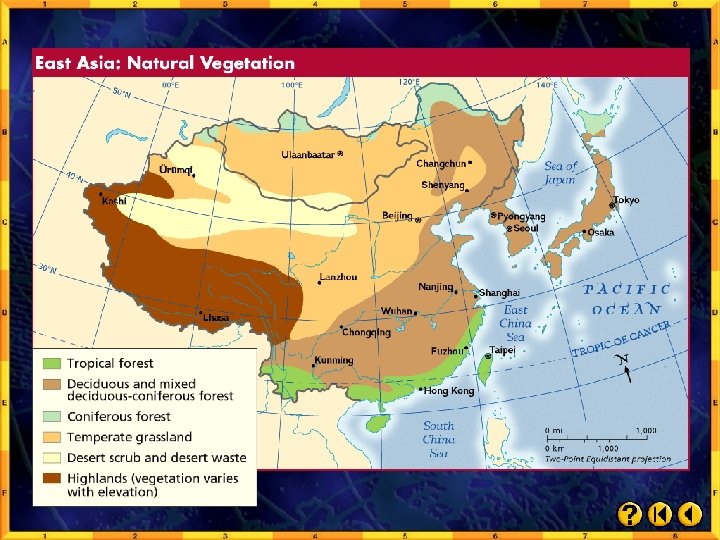
Analyzing Maps Region Compare the maps on the right. What kinds of vegetation characterize high latitude climates? Click the mouse button or press the Space Bar to display the answer.

Analyzing Maps The region’s higher latitudes have grassland, desert scrub and desert waste, and some forest.

Applying Geography Effects of Elevation Write a paragraph analyzing how mountains, plateaus, and lowlands affect East Asia’s climate and vegetation.

Close Name an East Asian country, and have your classmates identify its climate types and vegetation.

 Key Points • East Asia’s location at")
Section 1: The Land (pages 645– 650) Key Points • East Asia’s location at the meeting point of tectonic plates leaves the region vulnerable to earthquakes, volcanic eruptions, and tsunamis. • The region of East Asia consists of China, Mongolia, and North and South Korea on the Asian continent, plus the island countries of Japan and Taiwan. • East Asia’s rivers provide important transportation systems and support fertile farmlands. Click the mouse button or press the Space Bar to display the information.
 Key Points • East Asia is rich")
Section 1: The Land (pages 645– 650) Key Points • East Asia is rich in minerals, but they are unevenly distributed. • Limited farmlands, long coastlines, and large populations have made the region dependent on the sea for food. Click the mouse button or press the Space Bar to display the information.
 • East Asia’s natural")
Section 2: Climate and Vegetation Key Points (pages 651– 655) • East Asia’s natural vegetation tends to parallel the region’s climate zones. • East Asian countries rely on seasonal winds known as monsoons. The summer monsoons bring more than 80 percent of the region’s rainfall. • Ocean currents affect the climates of coastal and island regions. Powerful typhoons form in the Pacific and blow across coastal East Asia in later summer and early fall. Click the mouse button or press the Space Bar to display the information.
 • East Asia’s varied")
Section 2: Climate and Vegetation Key Points (pages 651– 655) • East Asia’s varied vegetation includes needleleaved and broad-leaved evergreen trees, tropical plants, bamboo, tea, mulberry trees, and grasses as well as tropical rain forest vegetation.


Reviewing Key Terms Insert the key term that matches the definition below. archipelago monsoon Japan Current tsunami loess typhoon 1. __________ large, fast-moving wave tsunami caused by an undersea earthquake 2. __________ chain or group of islands archipelago 3. __________ seasonal wind monsoon typhoon 4. __________ powerful, hurricane-like storm generated in the western Pacific Click the mouse button or press the Space Bar to display the answers.

Reviewing Key Terms Insert the key term that matches the definition below. archipelago monsoon Japan Current tsunami loess typhoon 5. __________ warm-water stream that Japan Current affects the climate in Japan 6. __________ fine, windblown topsoil loess Click the mouse button or press the Space Bar to display the answers.

Reviewing Facts Section 1: The Land On what landform are North and South Korea located? They are located on the Korean Peninsula. Click the mouse button or press the Space Bar to display the answer.

Reviewing Facts Section 1: The Land What is the largest and most densely populated of the Japanese islands? Honshu is the largest and most densely populated of the Japanese islands. Click the mouse button or press the Space Bar to display the answer.

Reviewing Facts Section 1: The Land Describe the natural hazards that result from East Asia’s location at the meeting point of three tectonic plates? Volcanoes, earthquakes, and tsunamis result from East Asia’s location at the meeting point of three tectonic plates. Click the mouse button or press the Space Bar to display the answer.

Reviewing Facts Section 1: The Land From which part of China do most of the region’s great mountain ranges extend? The region’s great mountain ranges extend from the Pamirs area in western China. Click the mouse button or press the Space Bar to display the answer.

Reviewing Facts Section 1: The Land What are China’s four major river or waterway systems? China’s four major river or waterway systems are the Yellow River, Yangtze River, Xi River, and the Grand Canal. Click the mouse button or press the Space Bar to display the answer.

Reviewing Facts Section 2: Climate and Vegetation Which economically important plants thrive in East Asia’s mid-latitudes? Bamboo, tea bush, and the mulberry tree thrive in East Asia’s mid-latitudes. Click the mouse button or press the Space Bar to display the answer.

Reviewing Facts Section 2: Climate and Vegetation What climate factor influences East Asia in seasonal cycles? Summer and winter monsoons influence East Asia in seasonal cycles. Click the mouse button or press the Space Bar to display the answer.

Reviewing Facts Section 2: Climate and Vegetation How are economic activities affected by climate in East Asia? The economy depends on monsoons to bring rains for the cops. Crops may fail if there is too much or too little rain. Click the mouse button or press the Space Bar to display the answer.

Reviewing Facts Section 2: Climate and Vegetation Which ocean current brings cold winters to Hokkaido? The Kuril (Oyashio) current brings cold winters to Hokkaido. Click the mouse button or press the Space Bar to display the answer.

Critical Thinking Making Generalizations How has the uneven distribution of natural resources most likely affected the economies of countries in the region? Possible answers: Smaller countries, such as Japan, Taiwan, and Korea, import and conserve limited resources, thus relying on trade. Abundant resources may enable China to be independent or to profit from exporting natural resources. Click the mouse button or press the Space Bar to display the answer.

Critical Thinking Analyzing Information Why might the countries surrounding the South China Sea compete for control of its waters? It is an important shipping area. Click the mouse button or press the Space Bar to display the answer.

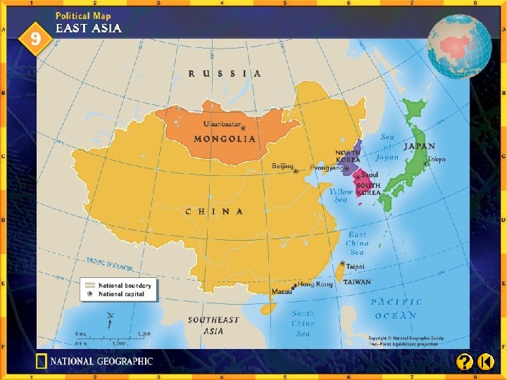
Locating Places Match the letters on the map with the physical features of East Asia. __1. Yellow River C __2. Yangtze River G __3. Mongolia E __4. Honshu A __5. Yellow Sea B __6. Plateau of Tibet F __7. Himalaya H __8. South Korea D __9. Taiwan I __10. North China Plain J Click the mouse button or press the Space Bar to display the answers.

Which country’s border is farthest north: Japan, China, or Mongolia? China’s border is farthest north. Click the mouse button or press the Space Bar to display the answer.

Explore online information about the topics introduced in this chapter. Click on the Connect button to launch your browser and go to the Glencoe World Geography Web site. At this site, you will find interactive activities, current events information, and Web sites correlated with the chapters and units in the textbook. When you finish exploring, exit the browser program to return to this presentation. If you experience difficulty connecting to the Web site, manually launch your Web browser and go to http: //geography. glencoe. com

Choose the best answer for the following multiplechoice question. If you have trouble answering the question, use the process of elimination to narrow your choices.

1. If you were to hike straight up Hsinkao Shan, what would be the most gradual route to take? A From the west B From the south C From the north D From the east Test-Taking Tip On a contour map, the closer the lines that show elevation (isolines), the faster the terrain rises and the steeper the topography. Where lines are far apart, the change in elevation is more gradual. To answer the question correctly, first find Hsinkao Shan on the map. Determine the side of the mountain where the lines seem farthest apart. Then choose the answer that best describes your observation. It also may be helpful to notice where the map lines are closest. You can then eliminate these choices from the answers. Click the mouse button or press the Space Bar to display the answer.

Bamboo grows more rapidly than any other living thing. Near Kyoto, Japan, scientists measured one bamboo culm, or stem, that grew almost 4 feet (1. 2 m) in 24 hours.

Mountains cover one-third of China. Only 14 mountain peaks in the world are higher than 26, 400 feet (8, 000 m). Of these, 9 are in China or along its southeastern border.

Mongolia With an average of over 257 cloudless days per year, Mongolia is known as the “Land of Blue Sky. ” Winters are bitter cold, but with air so dry that very little snow falls.

Mongolia Language: Population: Khalkha Mongol 2, 400, 000 4 per square mi. 2 per square km Landmass: 604, 826 square mi. 1, 566, 499 square km Currency: Tugrik Government: Republic Major Export Major Import Copper Fuels

Click the Speaker button to listen to the audio again.

Developing Multimedia Presentations You can take advantage of all available technologies and media forms to create classroom presentations. A multi-media presentation can engage the senses and capture the attention of your audience.

Developing Multimedia Presentations Learning the Skill A multimedia presentation uses several types of media to present information. These media may include audio, text, and graphics, such as slides, transparencies, animation, or videos. Any multimedia presentation should have a definite purpose. Before you begin to develop a presentation, state the purpose briefly in one or two sentences. Identifying the purpose will guide your research and help you select the media to use. Choosing the appropriate media from those available will help you communicate information most effectively. Showing a videotape of a graph during a presentation will probably not capture your audience’s attention. An overhead transparency might be a better tool for displaying a graph. To prepare a presentation on the recent migration patterns of East Asians, for example, you might display a combination of maps and photos showing past and present migrations.

Developing Multimedia Presentations Learning the Skill Use these questions to develop multimedia presentations: • What is my purpose? • Which forms of media will best show the kind of information I want to present? • Which media are available? • What computer software programs do I need, if any? • Does my computer support these software programs? Click the mouse button or press the Space Bar to display the information.

Developing Multimedia Presentations Practicing the Skill Answer the following questions about developing multimedia presentations. 1. What media tools would be most effective for a presentation about an important leader in East Asia? Graphics would be most effect, such as slides or video. 2. What media tools would be most effective for explaining population changes in East Asia? Transparencies would be most effect, including graphs, tables, or maps. Click the mouse button or press the Space Bar to display possible answers.

Developing Multimedia Presentations Practicing the Skill Answer the following questions about developing multimedia presentations. 3. What are some possible advantages and disadvantages of showing a Web site during a multimedia presentation? Web sites are colorful, dynamic, and engaging, but they may contain unwanted messages, may be difficult to see if the screen is small, and there may be technical difficulties. Click the mouse button or press the Space Bar to display possible answer.

Maps East Asia: Physical-Political East Asia: Climate Regions East Asia: Natural Vegetation Click on a hyperlink to view the corresponding slide.

Click the mouse button or press the Space Bar to display the answer.

Chengdu Click the mouse button or press the Space Bar to display the answer.

End of Custom Shows WARNING! Do Not Remove This slide is intentionally blank and is set to auto-advance to end custom shows and return to the main presentation.

- Slides: 110