Presentation Plus Glencoe World Geography Copyright by The

Presentation Plus! Glencoe World Geography Copyright © by The Mc. Graw-Hill Companies, Inc. Developed by FSCreations, Inc. , Cincinnati, Ohio 45202 Send all inquiries to: GLENCOE DIVISION Glencoe/Mc. Graw-Hill 8787 Orion Place Columbus, Ohio 43240

Chapter Introduction Section 1 The Land Section 2 Climate and Vegetation Chapter Summary & Study Guide Chapter Assessment Click on a hyperlink to view the corresponding slides.

Chapter Objectives • Describe the diverse landforms and natural resources of Australia, Oceania, and Antarctica. • Discuss the wide range of climates and vegetation throughout the region. Click the mouse button or press the Space Bar to display the information.

As you read this chapter, imagine that you are visiting interesting and beautiful locations in Australia, Oceania, and Antarctica. Write journal entries, using vivid details to explain why these places are appealing.

The Land Objectives • Describe how mountains, plateaus, and lowlands differ in Australia and New Zealand • Explain how volcanoes and continental shelves formed the islands of Oceania • Discuss why the physical geography of Antarctica attracts scientists Click the mouse button or press the Space Bar to display the information.

The Land Terms to Know • artesian well • coral • atoll • krill • lagoon Click the mouse button or press the Space Bar to display the information.

The Land Places to Locate • Australia • Great Dividing Range • Micronesia • Nullarbor Plain • New Zealand • Murray River • North Island • Darling River • South Island • Oceania • Antarctica • Melanesia Click the mouse button or press the Space Bar to display the information. • Polynesia

Click the Speaker button to listen to the audio again.

Rock climbing and mountain climbing are popular sports in Australia, even though most of the landscape is flat. The Great Dividing Range and the craggy island of Tasmania, among other places, provide many climbing opportunities. Even the city of Sydney boasts a rock climbing club and over 140 crags in its immediate area, ranging from breathtaking ocean cliffs to crags tucked into the suburbs. Within a two-hour drive of the city are more spectacular world-class climbing locations such as the Blue Mountains, Nowra, and Point Perpendicular.

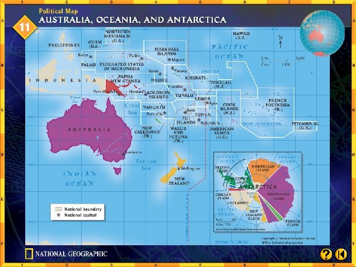
Australia: A Continent and a Country Australia is the only country in the world that covers an entire continent. Surrounded by water, Australia is really an island, but it is called a continent because of its tremendous size. • Mountains and Plateaus The Great Dividing Range is a chain of hills and mountains along the eastern coast of Australia’s otherwise flat landscape. (pages 793– 796) Click the mouse button or press the Space Bar to display the information.
 • The Western Plateau, or outback,")
Australia: A Continent and a Country (cont. ) • The Western Plateau, or outback, covers almost two-thirds of the continent. • This area includes three deserts. • South of the deserts lies the barren Nullarbor (“no tree”) Plain, which ends in cliffs overlooking the Indian Ocean. (pages 793– 796) Click the mouse button or press the Space Bar to display the information.
 (pages 793– 796) Click the Speaker")
Australia: A Continent and a Country (cont. ) (pages 793– 796) Click the Speaker button to listen to the audio again.
 • Central Lowlands This expanse of")
Australia: A Continent and a Country (cont. ) • Central Lowlands This expanse of grassland desert separates the Great Dividing Range from the Western Plateau. • Infrequent rains are heavy and fill the area’s usually dry lakes and rivers. • Below the surface lies the Great Artesian Basin, a source of underground water that ranchers use for livestock. (pages 793– 796) Click the mouse button or press the Space Bar to display the information.
 • Great Barrier Reef Lying off")
Australia: A Continent and a Country (cont. ) • Great Barrier Reef Lying off the eastern coast of Australia, this string of about 2, 500 coral reefs has been designated a national park and World Heritage Site. • The Great Barrier Reef provides a home for many species of tropical fish and sea creatures. (pages 793– 796) Click the mouse button or press the Space Bar to display the information.
 • Natural Resources Only 10 percent")
Australia: A Continent and a Country (cont. ) • Natural Resources Only 10 percent of Australian land is arable, but farmers use their resources efficiently. • The country’s major agricultural crops are wheat, barley, fruit, and sugarcane. • Arid areas are home to a livestockranching industry. (pages 793– 796) Click the mouse button or press the Space Bar to display the information.
 • Mineral resources include bauxite, coal,")
Australia: A Continent and a Country (cont. ) • Mineral resources include bauxite, coal, iron ore, lead, zinc, gold, nickel, and petroleum. • Australia is also a major producer of opals. (pages 793– 796) Click the mouse button or press the Space Bar to display the information.
 What do these geographical facts suggest")
Australia: A Continent and a Country (cont. ) What do these geographical facts suggest to you about where most Australians live? Possible answers: Since such a small percentage of the land is arable, the population is probably largely urban. The huge expanses of desert and barren plains would not be home to many people. Probably a fair number of people live and work on farms and ranches in the interior, but the population density there is likely to be low. (pages 793– 796) Click the mouse button or press the Space Bar to display the answer.

Oceania: Island Lands Oceania is a group of thousands of islands, some separated by great distances, that were formed by colliding tectonic plates millions of years ago. • Island Clusters The three main island clusters are Melanesia to the north and east of Australia; Micronesia to the north of Melanesia; and Polynesia, extending from Midway Island to New Zealand. (pages 796– 797) Click the mouse button or press the Space Bar to display the information.
 • Island Types High islands such as Fiji and")
Oceania: Island Lands (cont. ) • Island Types High islands such as Fiji and Tahiti feature volcanic mountains, some still active, and coastal plains. • Low islands such as the Marshall Islands are atolls–each a ring of land around a lagoon, the result of the buildup of coral reefs on a submerged volcano. • Continental islands include Papua New Guinea and New Caledonia. (pages 796– 797) Click the mouse button or press the Space Bar to display the information.
 • They feature rugged interior mountains and plains, swamps,")
Oceania: Island Lands (cont. ) • They feature rugged interior mountains and plains, swamps, and rivers along coastal areas. (pages 796– 797)
 (pages 796– 797) Click the Speaker button to listen")
Oceania: Island Lands (cont. ) (pages 796– 797) Click the Speaker button to listen to the audio again.
 Which type of island do you think is the")
Oceania: Island Lands (cont. ) Which type of island do you think is the least populated? Why? The low islands or atolls are the least populated, because they are made of coral rather than soil. People wouldn’t be able to farm, and there is probably little vegetation. (pages 796– 797) Click the mouse button or press the Space Bar to display the answer.

New Zealand: A Rugged Landscape • New Zealand’s two largest islands are called North Island South Island. • Both islands feature mountains, fertile soil, sparkling lakes, and scenic coastlines. • North Island includes hot springs and active volcanoes. • South Island features the Southern Alps and the fertile Canterbury Plains. (pages 797– 798) Click the mouse button or press the Space Bar to display the information.
 • About 55 percent of New Zealand’s")
New Zealand: A Rugged Landscape (cont. ) • About 55 percent of New Zealand’s land supports crops and livestock. • The country’s sheep and wool products dominate exports, and its forests yield valuable timber. • Most power is hydroelectric or geothermal (from water heated underground by volcanoes). • Several varieties of fish populate the coastal waters. (pages 797– 798) Click the mouse button or press the Space Bar to display the information.
 (pages 797– 798) Click the Speaker button")
New Zealand: A Rugged Landscape (cont. ) (pages 797– 798) Click the Speaker button to listen to the audio again.
 Would New Zealand’s environment be different if")
New Zealand: A Rugged Landscape (cont. ) Would New Zealand’s environment be different if New Zealanders used nuclear power plants or coal-burning power plants? The islands of New Zealand are not large; the ecology of the islands would probably be damaged. (pages 797– 798) Click the mouse button or press the Space Bar to display the answer.

Antarctica: A White Plateau • Antarctica is twice the size of Australia. • About 98 percent of Antarctica is covered by a massive ice cap that holds 70 percent of the world’s freshwater. • Activity on Antarctica is limited to scientific research. • Fishing boats sail coastal waters to harvest krill, a plentiful and protein-rich sea creature that may help alleviate world hunger. (page 798) Click the mouse button or press the Space Bar to display the information.
 Why do you think the countries of")
Antarctica: A White Plateau (cont. ) Why do you think the countries of the world have agreed not to permit mining and exploitation of Antarctica’s natural resources? Disturbing the unpolluted environment could put at risk the valuable scientific research being done there. (page 798) Click the mouse button or press the Space Bar to display the answer.

Checking for Understanding Define Match each definition in the left column with the appropriate term in the right column. __ 1. shallow pool of water at the D center of an atoll A. artesian well __ 2. tiny shrimplike sea animals that E live in cold Antarctic oceans C. atoll __ 3. ring shaped island formed by C coral building up along the rim of an underwater volcano __ 4. Wells from which pressurized A water flows to the surface __ 5. The limestone skeletons of a B tiny sea animal Click the mouse button or press the Space Bar to display the answers. B. coral D. lagoon E. krill

Critical Thinking Predicting Consequences What group of people would be most affected if Australia’s artesian wells dried up? Why? Ranchers would be most affected if the artesian wells dried up because they use the salty water to from the wells to water livestock. Click the mouse button or press the Space Bar to display the answer.

Critical Thinking Comparing and Contrasting Identify similarities and differences between New Zealand’s two main islands and a high island such as Tahiti. Possible answer: Similarities between New Zealand’s two main islands and a high island such as Tahiti could include the mountains, coastal plains, and active volcanoes. A difference is that New Zealand islands are larger and support more people. Click the mouse button or press the Space Bar to display the answer.

Critical Thinking Decision Making Of the three types of islands found in Oceania, which type would you choose for a home? Explain why.

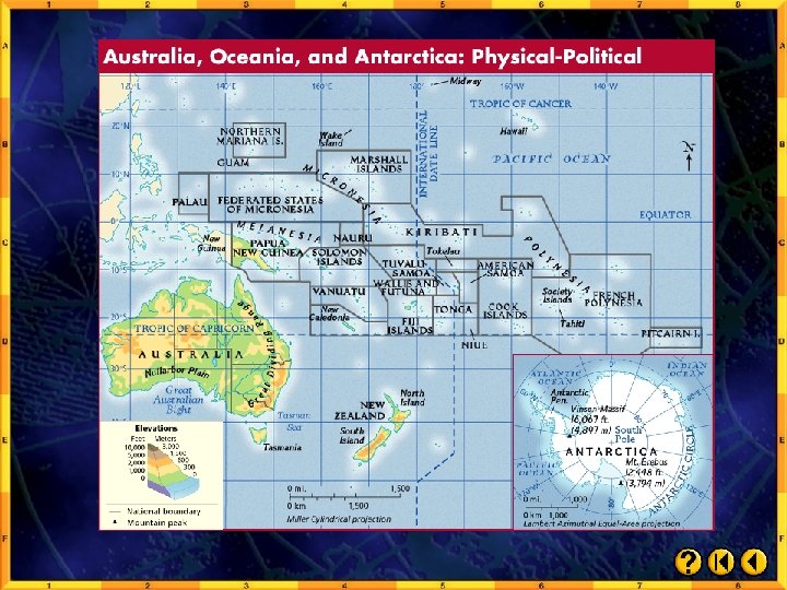
Analyzing Maps Location Study the physical-political map below. To which island region does Papua New Guinea belong? Click the mouse button or press the Space Bar to display the answer.

Analyzing Maps Papua New Guinea belongs to the island region of Melanesia.

Applying Geography Effects of Location Consider the location of Oceania’s islands in relation to other parts of the world. Write a paragraph explaining how this location might affect the development of natural resources.

Close Discuss ways in which the different lands in this region are alike and ways in which they are different. Aim to be as specific as possible.

Climate and Vegetation Objectives • Examine how variations in rainfall affect Australia’s climate and vegetation • Consider how elevation affects climate patterns in New Zealand • Identify what vegetation survives in the cold, dry Antarctic climate Click the mouse button or press the Space Bar to display the information.

Climate and Vegetation Terms to Know • wattle • doldrums • typhoon • manuka • lichen • crevasse Click the mouse button or press the Space Bar to display the information.

Climate and Vegetation Places to Locate • Papua New Guinea • Antarctic Peninsula Click the mouse button or press the Space Bar to display the information.

Click the Speaker button to listen to the audio again.
")
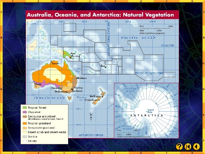
Eucalyptus trees are impressive in size, growing as tall as 300 feet (90 m) in their natural habitat of Australia. Aborigines have used the oil from eucalyptus leaves as an antiseptic to prevent infections and reduce fevers. Europeans began harvesting eucalyptus trees in the 1850 s. By the early 1900 s, Australia monopolized world trade in eucalyptus oil, used as a medicine (inhalant, antiseptic), in industry (oils, solvents), and in flavorings and perfumes. Today Australia exports only about 5 to 10 percent of the oil on the world market; China dominates production because of its low labor costs.

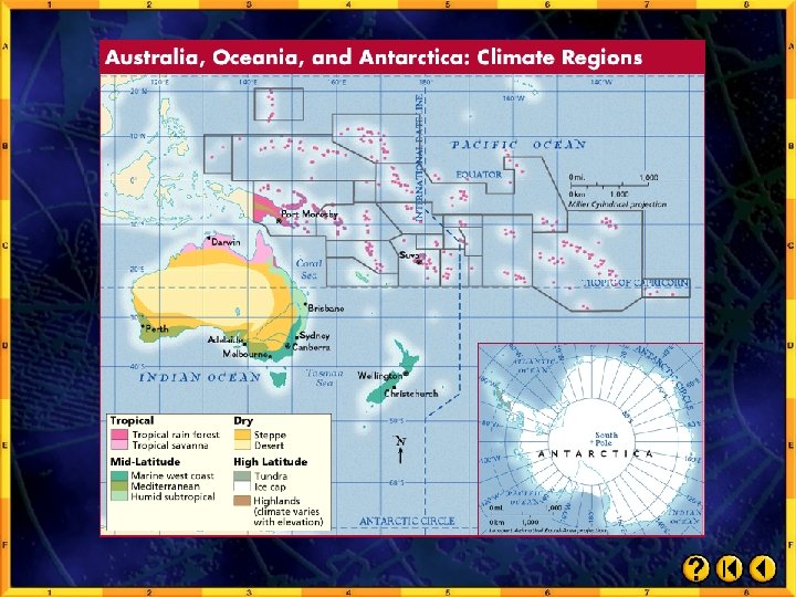
Australia • The Western Plateau is scorched by the sun during the day, but temperatures are much colder after dark. • The area receives less than 10 inches (25 cm) of rain annually, and its sparse vegetation does not support grazing. • The steppe climate in the area around the desert features more rainfall, so there is more vegetation. (pages 799– 801) Click the mouse button or press the Space Bar to display the information.
 • Annual rainfall during the wet season is between 10 and")
Australia (cont. ) • Annual rainfall during the wet season is between 10 and 20 inches (between 25 and 51 cm). • The area is ideal for grazing and can support some agriculture. • Coastal areas of Australia have moister climates. • These areas include most of the country’s farmland. (pages 799– 801) Click the mouse button or press the Space Bar to display the information.
 Which geographical features account for Australia’s great interior desert? Air masses")
Australia (cont. ) Which geographical features account for Australia’s great interior desert? Air masses block Pacific Ocean winds that would bring precipitation to the area. (pages 799– 801) Click the mouse button or press the Space Bar to display the answer.

Oceania • Most of Oceania features a tropical rain forest climate. • Temperatures are always warm except on some high mountain peaks, where the snow never melts. • Seasons alternate between wet and dry. • High islands get a lot of rain; low islands get very little. Oceania is vulnerable to typhoons. (page 802) Click the mouse button or press the Space Bar to display the answer.
 Why does snow remain on some mountaintops year-round? The higher the")
Oceania (cont. ) Why does snow remain on some mountaintops year-round? The higher the elevation, the colder the temperature. Some of the mountains are so high that the temperatures at their peaks are below freezing at all times. (page 802) Click the mouse button or press the Space Bar to display the answer.

New Zealand • New Zealand has a marine west coast climate, with cool summers and mild winters. • North Island’s central plateau is warm and sunny in summer, but mountaintops may be covered with snow year-round. • New Zealand averages 25 to 60 inches (64 to 152 cm) of rain yearly, but South Island’s Southern Alps receive as much as 315 inches (800 cm) annually. (pages 802– 803) Click the mouse button or press the Space Bar to display the information.
 Why are summers cool and winters mild in a marine")
New Zealand (cont. ) Why are summers cool and winters mild in a marine west coast climate? Ocean winds warm the land in winter and cool it in summer. (pages 802– 803) Click the mouse button or press the Space Bar to display the answer.
 (pages 802– 803) Click the Speaker button to listen to")
New Zealand (cont. ) (pages 802– 803) Click the Speaker button to listen to the audio again.

Antarctica • Antarctica is the world’s highest, driest, coldest, and windiest continent. • Temperatures may drop to – 129ºF (– 89ºC) in winter. • Snowfall varies from 2 to 24 inches (5 to 61 cm) annually. (pages 803) Click the mouse button or press the Space Bar to display the information.
 • Only the hardiest vegetation survives in Antarctica–mosses, algae, and lichens.")
Antarctica (cont. ) • Only the hardiest vegetation survives in Antarctica–mosses, algae, and lichens. • A small area on the Antarctic Peninsula, which is warmer than the rest of the continent, is home to Antarctica’s only two species of flowering plants. • Antarctica’s ice cap is frozen, but its weight causes it to move toward the coasts. • As it moves, the ice breaks into pieces. (pages 803) Click the mouse button or press the Space Bar to display the information.
 Why is there so little precipitation in Antarctica? Air loses its")
Antarctica (cont. ) Why is there so little precipitation in Antarctica? Air loses its moisture as it travels over Antarctica’s plateau. (pages 803) Click the mouse button or press the Space Bar to display the answer.

Checking for Understanding Define Match each definition in the left column with the appropriate term in the right column. __ 1. huge, deep crack that forms E in the thick ice or snow A. doldrums __ 2. small shrubs that grow in C plateau regions of New Zealand C. manuka __ 3. a frequently windless area A near the Equator B. typhoon D. wattle E. crevasse F. lichen __ 4. sturdy small plants that grow F like a crust on rocks or tree trunks __ 5. a violent tropical storm that forms in the B Pacific Ocean, usually in late summer __ 6. a woven framework made from acacia D saplings by early Australian settlers to build homes Click the mouse button or press the Space Bar to display the answers.

Critical Thinking Making Inferences What type of climate does most of New Zealand have? Why might it appeal to settlers? Possible answer: The marine west coast climate might appeal to settlers because of the cool summers and mild winters. Click the mouse button or press the Space Bar to display the answer.

Critical Thinking Problem Solving What problems might researchers encounter in Antarctica, and how could these conditions be overcome? Possible answer: As you answer the question, include well-reasoned ideas for overcoming the remote location, harsh climate, and barren landscape. Click the mouse button or press the Space Bar to display the answer.

Critical Thinking Identifying Cause and Effect How do Pacific ocean currents and winds affect the climate of Oceania? How do they affect vegetation? Possible answer: Pacific Ocean winds cool atolls and the windward sides of higher islands. Also, when larger, higher islands give off moisture-laden air, it mixes with cool ocean breezes and causes heavy rainfall. Rain forests thrive where heavy rains fall. Click the mouse button or press the Space Bar to display the answer.

Analyzing Maps Human-Environment Interaction Study the vegetation map on page 801 in your textbook. What type of vegetation is suitable for raising livestock, and where in Australia is it found? Click the mouse button or press the Space Bar to display the answer.

Analyzing Maps The grasslands circling the interior desert, and in the southeast are suitable for raising livestock.

Applying Geography Understanding Climate Maps Note the climate regions on the map on page 800 of your textbook. Write a paragraph explaining how climate relates to the way farmers operate in New Zealand Australia. Dry climates in much of Australia make irrigation of crops or use of artesian water for watering livestock necessary. New Zealand’s marine west coast climate, with its mild temperatures and greater rainfall, is more suitable to agriculture. Click the mouse button or press the Space Bar to display the answer.

Close Think of one original question and answer that you would add to the Section 2 Assessment.
 Key Points • Australia, both a country")
Section 1: The Land (pages 793– 798) Key Points • Australia, both a country and a continent, encompasses mountains, central lowlands, and expansive deserts. Rich mineral deposits and productive farms and ranches contribute to the Australian economy. • Oceania’s thousands of islands extend across the southern Pacific Ocean. The islands of Oceania were formed either directly or indirectly by volcanic activity. Click the mouse button or press the Space Bar to display the information.
 Key Points • New Zealand’s main features")
Section 1: The Land (pages 793– 798) Key Points • New Zealand’s main features are two large islands with mountain ranges, rivers, and lakes. The country boasts rich soil and timberland. • Antarctica is an ice-covered continent. While Antarctica may have important mineral resources, its key resource is the information it offers to scientists. Click the mouse button or press the Space Bar to display the information.
 • Australia generally has")
Section 2: Climate and Vegetation Key Points (pages 799– 803) • Australia generally has a hot, dry climate. Along the edges of the vast interior desert, the steppe receives sufficient rainfall for raising livestock. Only the coastal climates provide enough rainfall for growing crops without irrigation. • Oceania enjoys a warm, moist tropical climate. Most islands have wet and dry seasons. The amount of rain during the wet season determines whether shrubs and grasses or dense rain forests will grow. Click the mouse button or press the Space Bar to display the information.
 • New Zealand’s marine")
Section 2: Climate and Vegetation Key Points (pages 799– 803) • New Zealand’s marine west coast climate provides year-round rainfall, with temperatures that vary without being extreme. • Antarctica’s extremely cold and windy climate supports primarily lichens and mosses. Click the mouse button or press the Space Bar to display the information.

Reviewing Key Terms Define Match each definition in the left column with the appropriate term in the right column. __ 1. limestone skeleton of a tiny sea A. artesian well C animal B. atoll __ 2. windless area near the Equator C. coral E __ 3. shrimplike animal F __ 4. small, sturdy plant H __ 5. well, from which pressurized A water flows to the surface __ 6. huge crack in an ice cap D __ 7. small shrub that grows in New I Zealand Click the mouse button or press the Space Bar to display the answers. D. crevasse E. doldrums F. krill G. lagoon H. lichen I. manuka J. typhoon

Reviewing Key Terms Define Match each definition in the left column with the appropriate term in the right column. __ 8. pool of water inside an atoll G A. artesian well __ 9. violent Pacific Ocean storm J B. atoll __ 10. low, ring–shaped island B C. coral D. crevasse E. doldrums F. krill G. lagoon H. lichen Click the mouse button or press the Space Bar to display the answers. I. manuka J. typhoon

Reviewing Facts Section 1: The Land What formation lies just off Australia’s northeastern coast? The Great Barrier Reef is the formation that lies just off Australia’s northeastern coast. Click the mouse button or press the Space Bar to display the answer.

Reviewing Facts Section 1: The Land Name three types of islands that are found in Oceania. The three types of islands found in Oceania include high islands, low islands, and continental islands. Click the mouse button or press the Space Bar to display the answer.

Reviewing Facts Section 1: The Land What is New Zealand’s main natural resource? New Zealand’s main natural resource is land. Click the mouse button or press the Space Bar to display the answer.

Reviewing Facts Section 1: The Land List the local resources that help to meet New Zealand’s energy needs. Rivers and dams produce hydroelectric power and underground water heated by volcanoes produces geothermal energy. Click the mouse button or press the Space Bar to display the answer.

Reviewing Facts Section 2: Climate and Vegetation What climate supports most of Australia’s agricultural lands? A humid subtropical climate supports most of Australia’s agricultural lands. Click the mouse button or press the Space Bar to display the answer.

Reviewing Facts Section 2: Climate and Vegetation Describe the factor that prevents temperature extremes in New Zealand. Ocean winds warm the land in the winter and cool it in the summer. Click the mouse button or press the Space Bar to display the answer.

Reviewing Facts Section 2: Climate and Vegetation What causes the motion of the Antarctic ice cap? The weight of the ice cap causes the motion of the Antarctic ice cap. Click the mouse button or press the Space Bar to display the answer.

Critical Thinking Making Inferences Based on the information in Section 1, would you infer that Australia does or does not have an even distribution of population across the continent? Australia does not have an even distribution of population because of its mountains and deserts, where few people settle. Click the mouse button or press the Space Bar to display the answer.

Critical Thinking Comparing and Contrasting How are Oceania’s islands similar? Different? Oceania’s islands are similar because many were formed by volcanoes or many have active volcanoes. The islands are different in size, origin (i. e. from volcanoes or a rising ocean floor), and landforms (i. e. mountains, flat, or atolls). Click the mouse button or press the Space Bar to display the answer.

Locating Places Match the letters on the map with the physical features of Australia and New Zealand. __1. Great Barrier G Reef __2. Great Victoria A Desert __3. Great Dividing F Range __4. Tasmania D __5. Cape York C Peninsula __6. Great Australian E Bight Click the mouse button or press the Space Bar to display the answers.

Locating Places Match the letters on the map with the physical features of Australia and New Zealand. __7. Coral Sea J __8. Lake Eyre B __9. North Island I __10. South Island H Click the mouse button or press the Space Bar to display the answers.

Are rabbits native to New Zealand, or were they brought there by people? How do you know? Before people arrived, the only land mammals that could reach New Zealand were those that could fly. Therefore, rabbits had to be brought by people. Click the mouse button or press the Space Bar to display the answer.

Explore online information about the topics introduced in this chapter. Click on the Connect button to launch your browser and go to the Glencoe World Geography Web site. At this site, you will find interactive activities, current events information, and Web sites correlated with the chapters and units in the textbook. When you finish exploring, exit the browser program to return to this presentation. If you experience difficulty connecting to the Web site, manually launch your Web browser and go to http: //geography. glencoe. com

Use the chart below to choose the best answer for each of the following multiple-choice questions. If you have trouble answering the questions, use the process of elimination to narrow your choices.

1. If tourists were traveling to Australia in January and wanted to avoid both excessive heat and heavy rainfall, to which city should they travel? A Melbourne B Brisbane C Darwin D Sydney Test-Taking Tip Read the chart and become familiar with the information it contains before you answer the questions. Do not, however, study the chart in depth. The quickest way to answer both question 1 and question 2 is to read through each answer choice and use the process of elimination to get rid of those that you think are wrong. Click the mouse button or press the Space Bar to display the answer.

2. What information in the chart shows that the Australian cities are in the Southern Hemisphere? F July’s temperatures are higher than January’s. G January’s temperatures are higher than July’s. H The cities have abundant rain. J The cities have a dry season. Test-Taking Tip Read the chart and become familiar with the information it contains before you answer the questions. Do not, however, study the chart in depth. The quickest way to answer both question 1 and question 2 is to read through each answer choice and use the process of elimination to get rid of those that you think are wrong. Click the mouse button or press the Space Bar to display the answer.

Antarctica Scientists Click on a hyperlink to view the corresponding slide.

Antarctica, the world’s coldest and highest place, has mountains, valleys, and lowlands under its ice cap.

Scientists use satellites to learn about Antarctica. For example, satellite data confirm that the weight of Antarctica’s ice flattens the earth at the South Pole. As a result, the earth is actually pear shaped rather than round.

Lake Eyre is Australia’s largest lake and the lowest point on the continent. It fills with water only every five to ten years. During wet periods, the lake becomes a habitat for creatures and birds for about two years before returning to its dry state.

HISTORY In 1820 a Russian sea captain was the first person to record seeing Antarctica, and in 1898 Belgian sailors were the first people to spend a winter along Antarctica’s coast. There is no daylight for months during an Antarctic winter. The ship’s log tells how the prolonged darkness affected the sailors. “One seaman had fits…Another went mad. ”

Making Inferences You see a police car stopped behind another car by the roadside. The emergency lights are flashing on the police car. You infer, or conclude, that the driver was speeding based on the information you already have from similar circumstances. Making an inference means using information to draw a conclusion.

Making Inferences Learning the Skill When you hear about a country or an event in news reports or read about it in magazines and books, you may still have questions afterwards. Most sources do not contain all the information on a subject, but they may offer enough information for you to infer, or figure out, the answers to your questions. Different sources present information in different forms. Statistical charts, for example, often compare information from which you might infer differences, similarities, or trends over time. The steps on the following slides will help you make inferences from a chart. Click the mouse button or press the Space Bar to display the information.

Making Inferences Learning the Skill • Read the title and other labels to know what information the chart presents. • Determine whether the chart provides detailed information about one topic, compares two or more topics, or shows changes over time. Some charts may give several different types of information. • Make a list of the information that is not given in the chart, or the questions that arise from it. • Infer answers to your questions. Make logical inferences based on the facts given. Click the mouse button or press the Space Bar to display the information.

Making Inferences Practicing the Skill A tourist traveling to the Solomon Islands might use a chart to learn about the country. Answer the following questions by making inferences from the information in the chart on page 804 of your textbook. 1. Given the information in the chart on the first Practicing the Skill slide, is it more likely that the form of government in the Solomon Islands is a parliamentary democracy or a communist state? Explain. It is a parliamentary democracy because it was under British rule. Click the mouse button or press the Space Bar to display the answer.

Making Inferences Practicing the Skill A tourist traveling to the Solomon Islands might use a chart to learn about the country. Answer the following questions by making inferences from the information in the chart on page 804 of your textbook. 2. What can you infer about the health of the people in the Solomon Islands? Explain. Their health is generally good since life expectancy is a relatively high 67 years. Click the mouse button or press the Space Bar to display the answer.

Making Inferences Practicing the Skill A tourist traveling to the Solomon Islands might use a chart to learn about the country. Answer the following questions by making inferences from the information in the chart on page 804 of your textbook. 3. What can you infer about the animal life on the Solomon Islands? Explain. Animals would include species typical of a tropical rain forest environment. Click the mouse button or press the Space Bar to display the answer.

Making Inferences Practicing the Skill A tourist traveling to the Solomon Islands might use a chart to learn about the country. Answer the following questions by making inferences from the information in the chart on page 804 of your textbook. 4. What sorts of activities might a tourist enjoy in the Solomon Islands? Explain. Possible answers: Tourists visiting Solomon Islands might enjoy swimming, boating, fishing, or nature walks. Click the mouse button or press the Space Bar to display the answer.

Maps Australia, Oceania, and Antarctica: Physical. Political Australia, Oceania, and Antarctica: Climate Regions Australia, Oceania, and Antarctica: Natural Vegetation Click on a hyperlink to view the corresponding slide.

Click the mouse button or press the Space Bar to display the answer.

July, August, and September are three coldest months. Click the mouse button or press the Space Bar to display the answer.

End of Custom Shows WARNING! Do Not Remove This slide is intentionally blank and is set to auto-advance to end custom shows and return to the main presentation.
- Slides: 110