Preliminary Results from the TOPAZ Ozone Lidar Deployment

")


- Slides: 9
Preliminary Results from the TOPAZ Ozone Lidar Deployment at the CABOTS Campaign C. J. Senff, A. O. Langford, R. J. Alvarez II, G. H. Kirgis, A. M. Weickmann NOAA/ESRL/CSD & CU/CIRES • Instrument & data overview, boundary layer ozone dynamics (Chris) • STT ozone (Andy) 3 rd Annual TOLNet Workshop, 28 Jun 2016
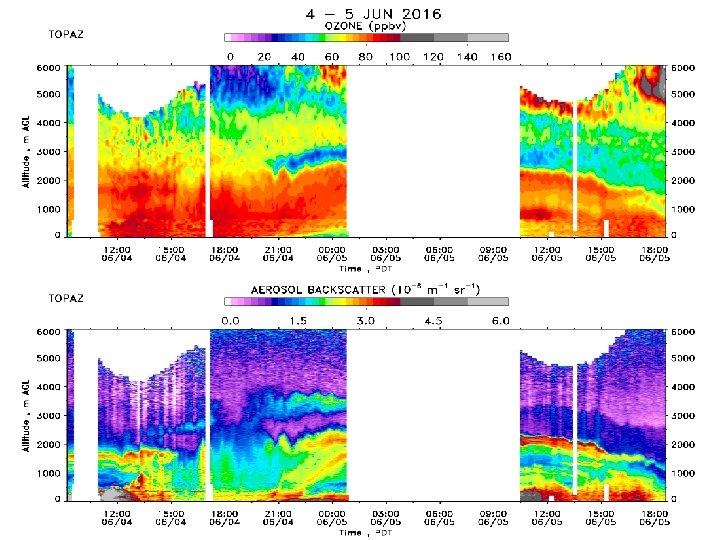
NOAA TOPAZ Ozone Lidar (TOPAZ = Tunable Optical Profiler for Aerosol and o. Zone) • Compact, tunable UV ozone DIAL Airborne: 2006 - 2010 • Ozone and aerosol backscatter profiles from ~ 15 m up to 8 km AGL Truck-based: 2011 - 8 km 90° 20° 6° Composite vertical O 3 and aerosol profiles every 8 min 2° TOLNET www-air. larc. nasa. gov/missions/TOLNet/ JPL ESRL GSFC UAH La. RC
TOPAZ lidar @ CABOTS Objective: Understand to what extent trans-Pacific long-range transported ozone mixes down to the surface and affects air quality in the San Joaquin Valley. Visalia Municipal Airport TOPAZ Hwy 99 SJVAPCD Wind Profiler 29 May – 18 Jun, 2016 1 st TOPAZ deployment ✔ 18 Jul – 7 Aug, 2016 2 nd TOPAZ deployment
TOPAZ lidar @ CABOTS NASA Ames Alpha Jet UC Davis / Sci. Aviation Mooney Photo Credit: Will von Dauster TOPAZ Truck
211 hours on 21 days
Complex wind flow pattern and low summertime BL heights play an important role in the transport and distribution of pollutants in the San Joaquin Valley Summertime low-level wind flow patterns in California’s Central Valley Bao, J. -W. et al. , 2008: Observed and WRF-Simulated Low. Level Winds in a High-Ozone Episode during the Central California Ozone Study, J. Appl. Meteor. Climatol. , 47, 23722394. Annual variability of BL height in California’s Central Valley Bianco, L. et al. , 2011: Diurnal Evolution and Annual Variability of Boundary-Layer Height and Its Correlation to Other Meteorological Variables in California’s Central Valley, Boundary-Layer Meteorol. , 140, 491 -511.
3