PREDICTING THE ONSET OF THE NORTH AMERICAN MONSOON


- Slides: 24

PREDICTING THE ONSET OF THE NORTH AMERICAN MONSOON AND PROGRESS TOWARD A MECHANISTIC UNDERSTANDING 2. 4. David L. Mitchell 1, Dorothea Ivanova 1, Beth Hall 1, Miguel F. Lav n 2, and Affonso S. Mascarenhas, Jr. 3 1. Desert Research Institute, Reno, Nevada, USA 2. Centro de Investigaci n Cient fica y de Educaci n Superior de Ensenada (CICESE), 3. Ensenada, Baja California, Mexico 3. Instituto de Investigaciones Oceanologicas, Universidad Autonoma de Baja California, 5. Ensenada, Baja California, Mexico

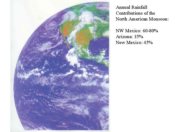
Annual Rainfall Contributions of the North American Monsoon: NW Mexico: 60 -80% Arizona: 35% New Mexico: 45%


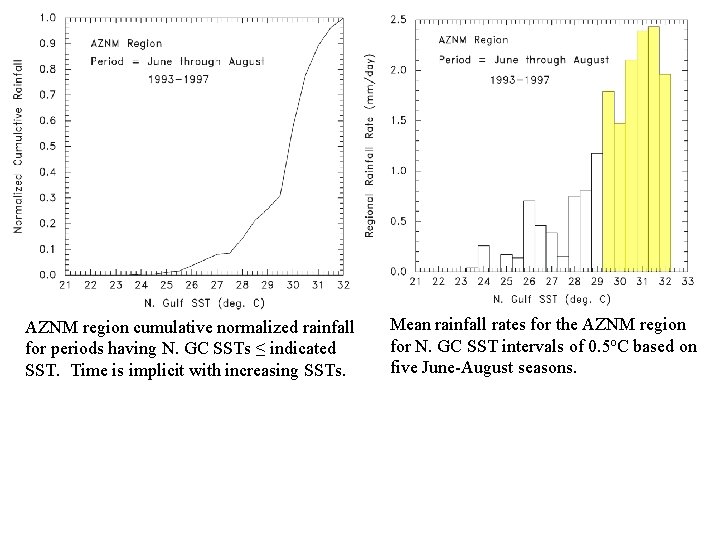
AZNM region cumulative normalized rainfall for periods having N. GC SSTs ≤ indicated SST. Time is implicit with increasing SSTs. Mean rainfall rates for the AZNM region for N. GC SST intervals of 0. 5 o. C based on five June-August seasons.

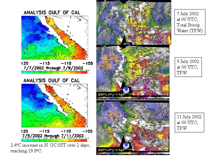
7 July 2002 at 00 UTC, Total Precip. Water (TPW) 9 July 2002 at 00 UTC, TPW 11 July 2002 at 00 UTC, TPW 2. 4 o. C increase in N. GC SST over 2 days, reaching 29. 8 o. C.

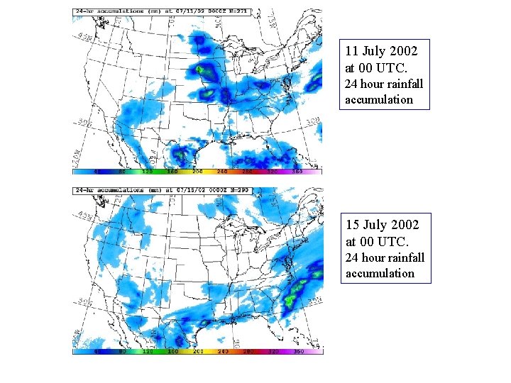
11 July 2002 at 00 UTC. 24 hour rainfall accumulation 15 July 2002 at 00 UTC. 24 hour rainfall accumulation

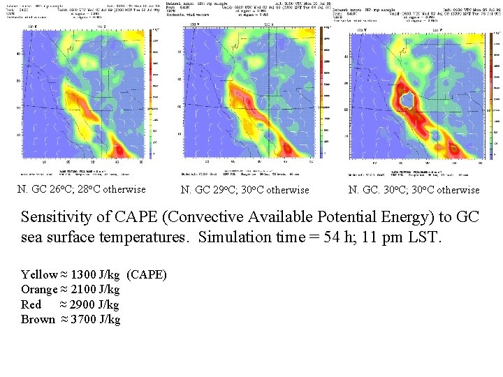
N. GC 26 o. C; 28 o. C otherwise N. GC 29 o. C; 30 o. C otherwise N. GC. 30 o. C; 30 o. C otherwise Sensitivity of CAPE (Convective Available Potential Energy) to GC sea surface temperatures. Simulation time = 54 h; 11 pm LST. Yellow ≈ 1300 J/kg (CAPE) Orange ≈ 2100 J/kg Red ≈ 2900 J/kg Brown ≈ 3700 J/kg

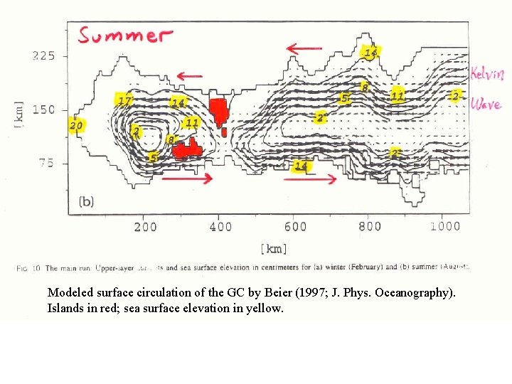
Modeled surface circulation of the GC by Beier (1997; J. Phys. Oceanography). Islands in red; sea surface elevation in yellow.

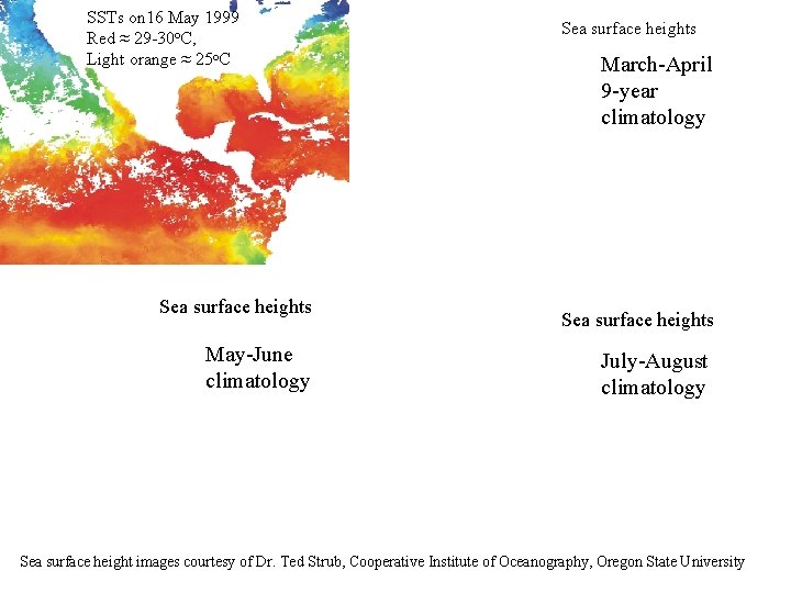
SSTs on 16 May 1999 Red ≈ 29 -30 o. C, Light orange ≈ 25 o. C Sea surface heights May-June climatology Sea surface heights March-April 9 -year climatology Sea surface heights July-August climatology Sea surface height images courtesy of Dr. Ted Strub, Cooperative Institute of Oceanography, Oregon State University

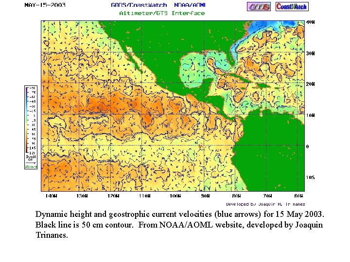
Dynamic height and geostrophic current velocities (blue arrows) for 15 May 2003. Black line is 50 cm contour. From NOAA/AOML website, developed by Joaquin Trinanes.

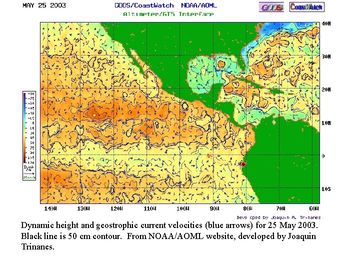
Dynamic height and geostrophic current velocities (blue arrows) for 25 May 2003. Black line is 50 cm contour. From NOAA/AOML website, developed by Joaquin Trinanes.

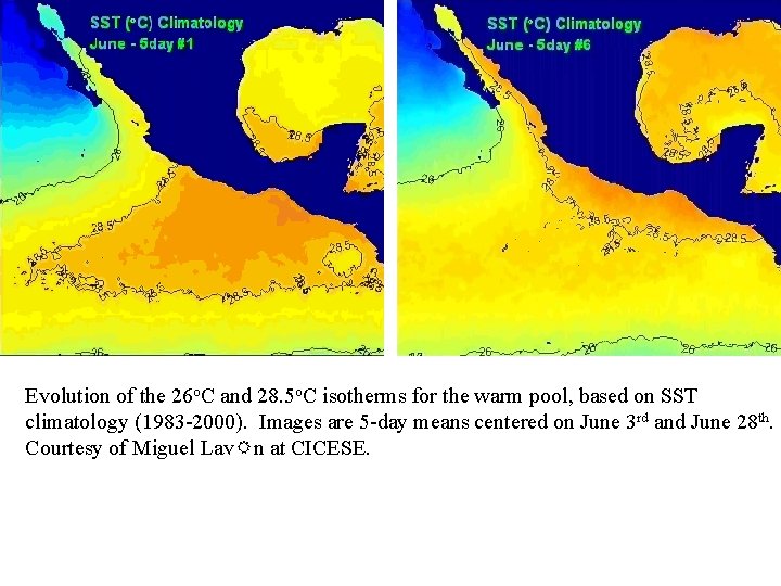
Evolution of the 26 o. C and 28. 5 o. C isotherms for the warm pool, based on SST climatology (1983 -2000). Images are 5 -day means centered on June 3 rd and June 28 th. Courtesy of Miguel Lav n at CICESE.

Based on 10 seasons of TOPEX/POSEIDON satellite altimeter data. Preliminary analysis relating the May SHA Index to the onset of the 29. 5 o. C N. GC SST. Sea height anomaly (SHA) index based on anomalies in 3 coastal and 1 open ocean region. Coastal: GC entrance, between the “Cape” and GC entrance, and southern Mexico Open Ocean: Off southern Mexico (the “dome”) 1 rating point = | 3 cm sea surface height | Negative coastal ratings: SHA Index = |coastal rating – 1. 5| + off-shore rating Positive coastal ratings: SHA Index = off-shore rating – coastal rating


Statewide AZ June-August rainfall amounts, 1983 -2002, vs. N. GC 29. 5 o. C onset date, using 18 or 14 km weekly SSTs from JPL or NOAA. Zero and negative values are prior to July 1 st. Horizontal line = median rainfall value.

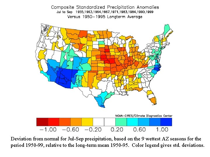
Deviation from normal for Jul-Sep precipitation, based on the 9 wettest AZ seasons for the period 1950 -99, relative to the long-term mean 1950 -95. Color legend gives std. deviations.

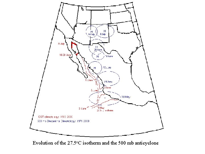
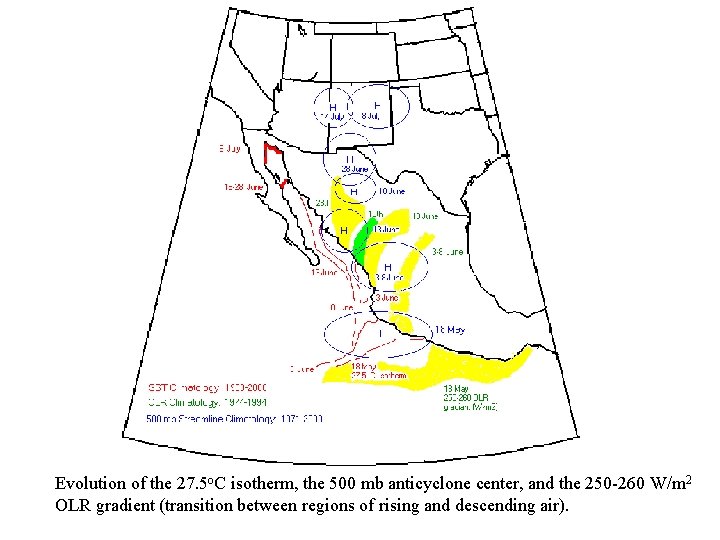
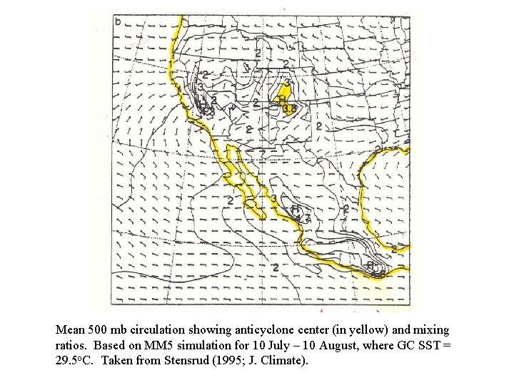
Poleward Migration of the North American Anticyclone: Working Hypothesis 1. As warm SSTs ( > 26 o. C) move up the Mexican coast, deep convection is triggered as shown previously and in earlier work. 2. The poleward advance of deep convection over the Sierra Madre Occidental is accompanied by a branch of descending air aloft to the north of the deep convection. This may position the center of the anticyclone. 3. The observed SST-rainfall relation implies the anticyclone’s position depends on the poleward extent of the warm SSTs. 4. The mid-level monsoon moisture supply is largely governed by this anticyclone, with moist tropical air often to the south and west of the anticyclone center. The summer circulation over North America is dominated by this anticyclone.

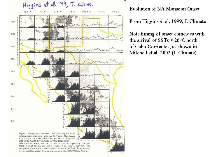
Evolution of NA Monsoon Onset From Higgins et al. 1999, J. Climate Note timing of onset coincides with the arrival of SSTs > 26 o. C north of Cabo Corrientes, as shown in Mitchell et al. 2002 (J. Climate).

Evolution of the 27. 5 o. C isotherm and the 500 mb anticyclone

Evolution of the 27. 5 o. C isotherm, the 500 mb anticyclone center, and the 250 -260 W/m 2 OLR gradient (transition between regions of rising and descending air).

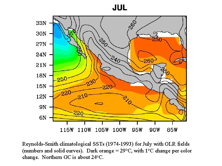
MM 5 simulations of the anticyclone at 600 mb for July, using 3 convection schemes: (a) Betts. Miller-Janjic, (b) Kain-Fritsch and (c) Grell. Taken from Gochis et al. 2002, Sensitivity of the Modeled North American Monsoon Regional Climate to Convective Parameterization, Mon. Wea. Rev. , Vol. 130, 1282 -1298. Simulations based on Reynolds-Smith SST data (optimum interpolation method), which underestimate the GC SSTs by 2 -6 o. C during July, especially in the northern GC. The position of the anticyclone below US-Mexico border is consistent with hypothesis that its position depends on the latitude of the warmest coastal SSTs.

Reynolds-Smith climatological SSTs (1974 -1993) for July with OLR fields (numbers and solid curves). Dark orange = 29 o. C, with 1 o. C change per color change. Northern GC is about 24 o. C.

Mean 500 mb circulation showing anticyclone center (in yellow) and mixing ratios. Based on MM 5 simulation for 10 July – 10 August, where GC SST = 29. 5 o. C. Taken from Stensrud (1995; J. Climate).

SUMMARY 1. Previous work based on satellite observations and modeling reveal the existence of a threshold SST of about 29. 5 o. C for the northern GC that triggers widespread and relatively heavy rainfall in Arizona. Moreover, the incremental advance of SSTs > 26 o. C up the Mexican coast appears necessary for the northward advance of the monsoon. 2. The extremely warm water in the GC appears primarily due to advection of warm pool water into the GC during May-July, resulting in a dramatic reconfiguration of the warm pool 28. 5 o. C isotherm (based also on earlier studies from UABC and CICESE). More research is needed to confirm this. 3. The onset of relatively heavy rainfall in AZ may be forecast 1 -2 months in advance, based on a relationship linking sea surface topography with the arrival of N. GC SSTs 29. 5 o. C. The timing of this onset indicates whether AZ ( the Midwest) is likely to be average-to-wet (average-to-dry) or whether AZ is likely to be average-to-dry during the period June-August. A more rigorous analysis is needed to confirm these results. 4. Satellite SST and OLR data, and reanalysis data, suggest that the poleward migration of the North American 500 mb anticyclone during spring/summer may depend on the poleward advance SSTs > 26 o. C up the Mexican coast. This corroborates well with MM 5 modeling results, that show the mean July position of the anticyclone is much farther south when unrealistically cool GC SSTs are used. This anticyclone dominates the summer mid-level circulation over North America.