Political Geography Transition Zones Until recently many boundaries

Political Geography

Transition Zones • Until recently many boundaries were not sharp, clearly defined lines, but were zones called marchlands • Frontiers - area between two states or between inhabited and uninhabited areas – Now rare since most modern govts. have technology and want to exploit all territory to the fullest

Boundary Processes • definition: negotiate a treaty to establish a border • delimitation: cartographers (mapmakers) then draw the boundary on a map • demarcation: physically representing the border on the Earth’s surface

Boundaries and Borders Origins: • Antecedent – Existed in prehistoric times before human settlement affects cultural landscape – Usually align with physical boundaries – Cultural groups spread toward border but don’t cross • South Asia/East Asia = Himalayas • Sino-Tibetan vs. Indo. Aryan/Dravidian • Always existed but now forms border

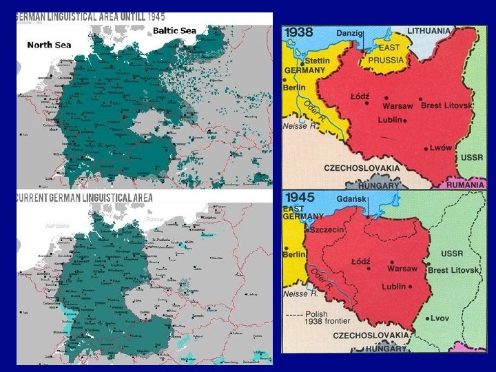
Boundaries and Borders Origins: • Antecedent • Subsequent – Resulting from changes brought on by conflict or culture • Post WWI and Post-WWII Europe

Boundaries and Borders Origins: • Antecedent • Subsequent • Superimposed – Lines laid down for political reasons disregarding cultural boundaries • the Scramble for Africa

Boundaries and Borders Origins: • Antecedent • Subsequent • Superimposed • Relic – Former boundary that still has meaning • East and West Germany – divided into 2 states during Cold War – border now obsolete one Germany – but still has meaning economically and politically

Boundaries and Borders Types: • Physical – Natural geography like rivers, lakes, oceans, mountains or deserts • Cultural – Human features (language, religions, other) • “isogloss” • Geometric – Survey lines usually along lines of latitude and longitude • Borders extend in a plane above and below the Earth

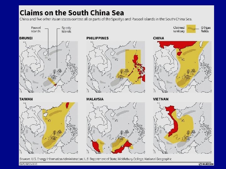
Boundary Disputes • Definitional – Treaties are interpreted two different ways. – What are the precise legal definitions of the borders? • If we are drawing a border at the midpoint of a river are we doing that at high tide or low tide” • Locational – When the border moves (ie: a river changes course) – overlaps with “definitional” – How do you address a change in a border such as a river bed or lake drying up? • Operational – Border is recognized, but how to pass through it becomes problematic – Immigration/trade/paperwork, etc. • Allocational – When a resource lies on two sides of a border who gets what?

Water Boundaries at Sea • Est. by the UN Conference on the Law of the Seas (ratified 1994) – Territorial • Sovereignty extends 12 nautical miles from shore • All national laws apply • Beyond 12 mi. = high seas, admiralty law applies – Exclusive Economic Zone (EEZ) • Exclusive economic rights extend 200 nautical miles from shore • Natural resources, fishing, etc. • If overlap, generally split halfway, but many areas are under dispute

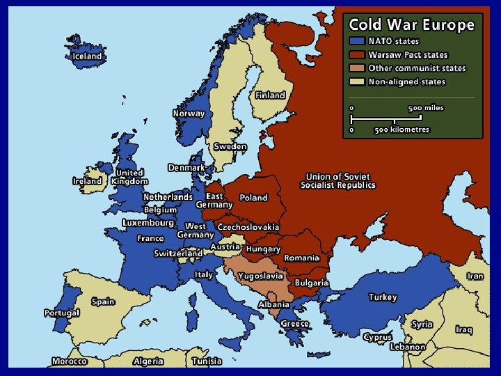
Transition Zones • Until recently many boundaries were not sharp, clearly defined lines, but were zones called marchlands • Frontiers - area between two states or between inhabited and uninhabited areas – Now rare since most modern govts. have technology and want to exploit all territory to the fullest • Buffer state — independent but weak country lying between two powerful countries – Mongolia—lies between Russia and China – Afghanistan- between Russian Empire and British India • Satellite state -- a state that falls under the domination of another (usually neighboring) and loses much of its independence (aka: puppet state) – Eastern European countries under Soviet domination during the Cold War
- Slides: 14