Political Geography Key Issue 3 Key Issue 3


- Slides: 55
Political Geography Key Issue 3
Key Issue 3 Why Do Boundaries Cause Problems?
CLICK TO LEARN MORE Boundaries vs. Frontiers • A state is separated from its neighbors by a boundary, an invisible line the marks the extent of a state’s territory. • Historically, frontiers- zones where no state exercises complete political control- rather than boundaries separated states.
Making Boundaries • Boundary definition – determining the boundary by a treaty-like agreement through actual points, latitude/longitude, or landscape • Boundary delimitation – the boundary is drawn on the map • Boundary demarcation – the boundary is physically established by steel posts, concrete pillars, fences, etc. to mark the boundary on the ground
Three Types Of Physical Boundaries Desert Boundaries- effectively divide two states, because deserts are hard to cross and sparsely inhabited. Mountain Boundaries- effectively divide two states, if the mountains are difficult to cross. Useful boundaries because of their permanent quality and tendency to be sparsely populated. Water Boundaries- include rivers, lakes, and oceans. Less permanent overall than mountain boundaries because of tendencies of water levels to change in bodies of water and river channels to move over time.
RLEs Mountain boundaries Water boundaries most common!
Types of Cultural Boundaries Geometric Boundaries • Straight lines drawn on a map. • 2, 100 -kilometer (1, 300 -mile) straight line along 49º north latitude that separates the U. S. and Canada Ethnic Boundaries • Boundary coincides with differences in ethnicity, especially language and religion. • Language differences influenced the boundaries in England, France, Portugal, and Spain before the 19 th century in Europe.
Geometric Boundary • The Aouzou strip was defined for the first time in the discussions between France and Italy after World War I, in relation to an award to Italy for the victory in that war.
Antecedent Boundaries existed before the area was settled. People knew in advance when they moved into a region which side of the border they were living on.
Subsequent Boundaries are established after an area has been settled. • Consequent boundaries are drawn to accommodate religious, ethnic, language differences. (because of) • RLEs Northern Ireland Pakistan/Bangladesh • Superimposed boundaries ignore existing cultural aspects of a region. • RLE continent of Africa Tribal Boundaries Political Boundaries
Cyprus’s Green Line • The zone/division is product of, tension simmered between Greek and Turkish Cypriot communities. • The buffer zone is 110 miles long, and is controlled by United Nations peacekeepers. • The “Green Line” buffer zone takes up about three percent of the island.
Relic Boundary A “relic” on the landscape. It no longer exists, but its impact is still felt. The Berlin Wall and the border separating East and West Germany no longer exists, but it is still felt economically and culturally.
Boundary Disputes • Since Word War II, almost half of the world’s sovereign states have been involved in border disputes with their neighbors. • The more neighbors a state has… the greater the likelihood of conflict.
Definitional Boundary Disputes • occur when states argue about where the already-agreed-on border is located. • RLE The boundary between Argentina and Chile follows the crest of the Andes Mountains AND the watershed, which do not always coincide.
Locational Boundary Disputes • disagreement over the demarcation or delimitation of a border • arise over the ownership of a region, usually around mutual borders. RLE Ethiopia and Somalia: the border was drawn wrong on a map
Allocational Boundary Disputes Involve natural resources that lie in border areas. May include: • mineral deposits • fertile farmland • rich fishing groups RLEs • U. S. and Canada: fishing rights • China and Japan: natural gas deposits
Operational Disputes • when neighboring states cannot agree on policies that apply in a border area. • RLE the ongoing immigration debate between the U. S. and Mexico
States: Size and Shapes
Site and Situation… Absolute And Relative Location The significance of size and shape as factors in national well-being can be modified by a state’s location, both absolute and relative.
Size of States Size alone is not critical in determining a country’s power and stability, but it is a contributing factor.
Large States Advantages • Although it depends on location, large size increases the chances of having important natural resources • mineral ores • fertile soil Disadvantages • Location can affect accessibility of natural resources. • So far north that much of their land is frozen • Parts of the countries impossible to do farming or mining • Examples: Russia and Canada
Small States Advantages • They are more likely to have a homogeneous population so conflict is minimized. • They may also wield power beyond their size. • Example: Britain, with its many natural and human resources
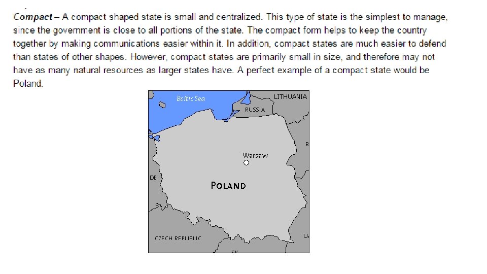
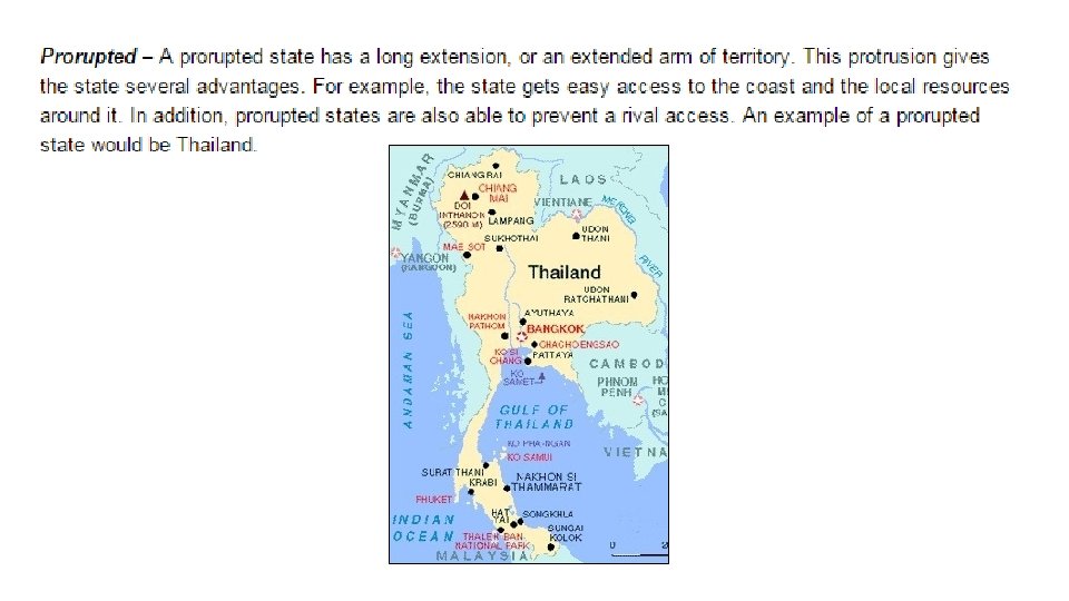
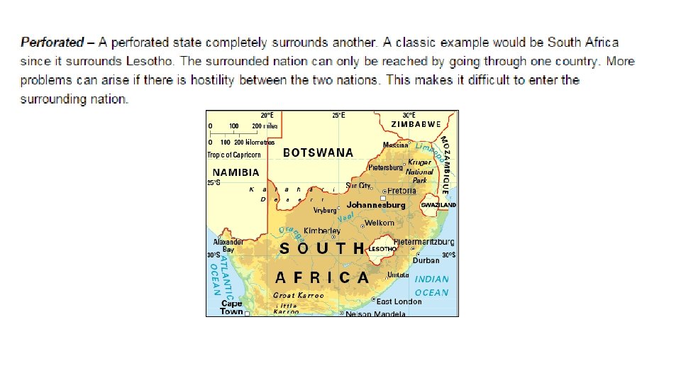
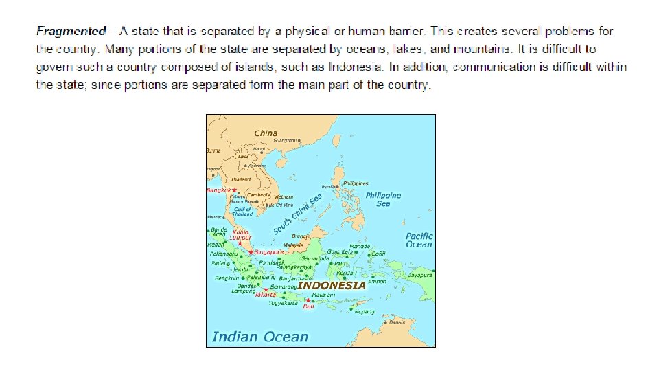
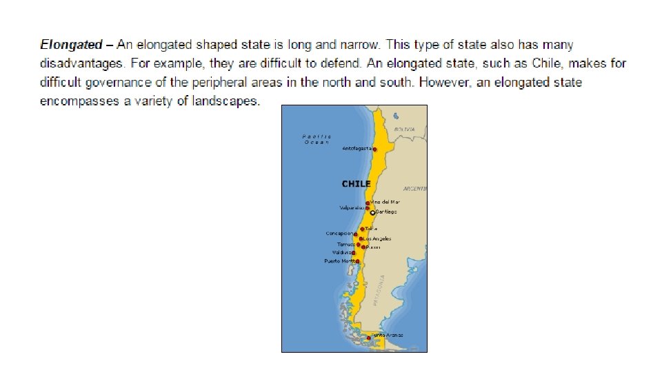
State Morphology: Shapes of States START HERE! CLICK FOR PREZI
Thinking Like A Geographer • Is one shape better than another? • What other factors lead to the success of a state?
Why Care? Shapes of States… • Control the length of its boundaries with other states. • Affect the potential for communication and conflict with neighbors. • Are a part of a country’s unique identity. • Influences the ease or difficulty of internal administration and can affect social unity.
Landlocked States • The prevalence of landlocked states in Africa is a remnant of the colonial era, when Britain and France controlled extensive regions. • Direct access to an ocean is critical to states because it facilitates international trade. • • To send and receive goods by sea, a landlocked state must arrange to use another country’s seaport.
Enclaves • a "hole" in a political territory created by a sovereign or semi-sovereign entity (like a state, tribal homeland, or Indian reservation) or by a fragment of a foreign country
Exclaves • a bit of a state that is separated from the rest of the state, • Alaska (a U. S. exclave) • Kaliningrad (a Russian exclave bordering Lithuania and Poland on the Baltic Sea) Kaliningrad Exclave of Russia
Watch and Learn!
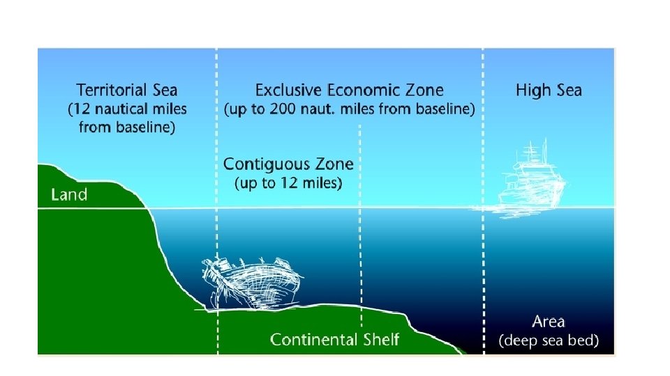
Maritime Boundaries: Law of the Sea International treaty that sets environmental and commercial terms for use of the world's oceans. • protects the ocean from environmental degradation • establishes guidelines for businesses that depend on the sea for resources • defines maritime zones, and preserves freedom of navigation. 162 nations have signed and ratified this treaty= but NOT the United States (but we voluntarily obey the terms of the treaty. )
162 Countries… But NOT the USA CLICK TO SEE EACH POV
January 2016
The Geography of Government and Politics
capitalism feminism terrorism communism fascism racism socialism Top 7 Looked-Up Words 2015
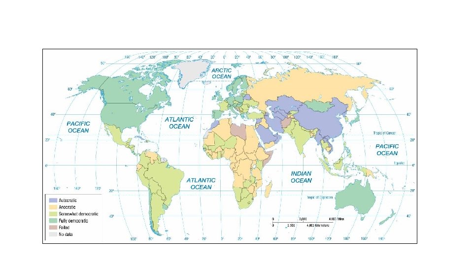
3 Categories of Governments National governments can be classified as democratic, autocratic, or anocratic. • A democracy is a country in which citizens elect leaders and can run for office. (USA, Norway, Australia) • An autocracy is a country that is run according to the interests of the ruler rather than the people. (Cuba, Saudi Arabia, China) • An anocracy is a country that is not fully democratic or fully autocratic, but rather a mix of the two. (Cambodia, Russia, Nigeria)
Draw a Graph Democracies Selection of Leaders Citizen Participation Checks and Balances RLEs Autocracies
Democracies vs. Autocracies Citizen Participation • Democracies: executive power is limited by written law. • Autocracies: citizens’ participation restricted or suppressed. Selection of Leaders • Democracies: citizens vote • Autocracies: leaders are selected from within the political elite. Checks and Balances: • Democracies: guarantee civil liberties to all citizens. • Autocracies: leaders exercise power with no meaningful checks from government or civil institutions.
CLICK FOR INTERACTIVE DATA
Who Has the Power?
CLICK FOR DATA The world has become more democratic since the 19 th century.
CLICK FOR DATA
Electoral Geography • Boundaries separating 435 legislative districts within the U. S. and other countries are redrawn every 10 years to ensure each has about the same population. • Process of redrawing legislative boundaries for the purpose of benefits the party in power is called gerrymandering.
Gerry’s Salamander- 1812 CLICK to WATCH
CLICK to WATCH 3 Ways to Use Gerrymandering 1. Cracked/Wasted vote spreads opposition supporters across many districts but in the minority. 2. Packed/Excess vote concentrates opposition supported into a few districts. 3. Stacked vote links distant areas of like-minded voters through oddly shaped boundaries. U. S. Supreme Court ruled gerrymandering illegal in 1985 but did not require dismantling of existing oddly shaped districts.
Cracked Stacked Packed
Texas Congressional Districts CLICK FOR DATA
CLICK to WATCH Redistricting in Texas SCOTUS will rule on this case in 2016
Political Geography End of Key Issue 3