Political Geography Evolution of the contemporary political pattern


 to gain power")
 AN ORGANIC STATE • “The state")
 Germ. • Ideas used by Nazi party")
 English geographer • Believed the greatest")

 agreed that Eurasia was the likely base")


 disputes")
 disputes")


- Slides: 42
Political Geography Evolution of the contemporary political pattern Territoriality – how Earth’s surface should be organized
Debra Troxell, NBCT
19 th Cent. Geo. Politics • Colonization • Mercantilism • Imperialism • White Man’s Burden • Manifest • Monroe Destiny Doctrine
Remember “The White Man’s Burden”? ? ? Which one do you think is more accurate?
• Alfred T. Mahan – US (1? ? 0 -1914) to gain power must control sea lanes
The German School • Friedrich Ratzel (1844 -1904) AN ORGANIC STATE • “The state resembles a biological organism whose life cycle extends from birth through maturity and, ultimately, decline and death. To prolong its existence, the state requires nourishment, just as an organism needs food. Such nourishment is provided by the acquisition of territories belonging to less powerful competitors” -lebensraum. (de. Blij 245) • An extreme form of environmental determinism • Justified Nazi expansion
Geo. Politiks • Karl Haushofer (1869 -1946) Germ. • Ideas used by Nazi party for Germany’s theories of race superiority and need for territorial conquest. Promoting A land & sea power Lebensraum (living space) Autarky (economic self-sufficiency) Organic state • His student was Rudolf Hess
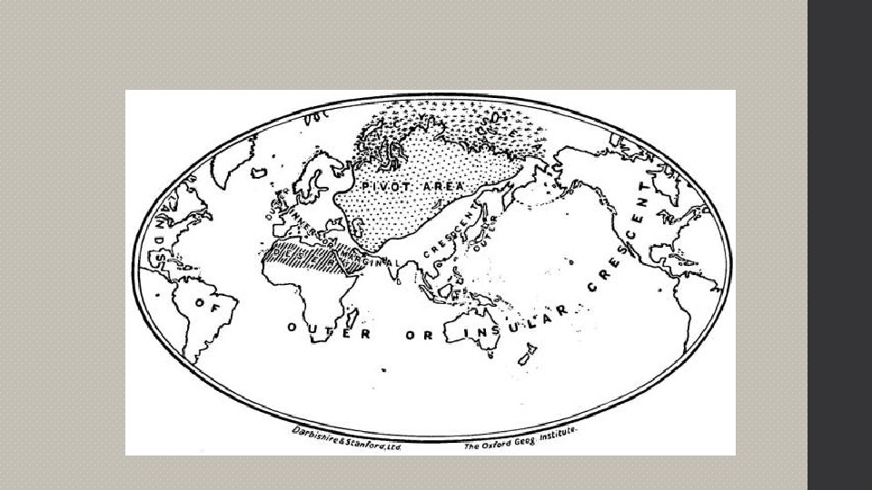
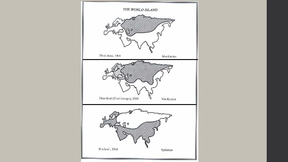
Heartland Theory • Halford Mackinder, Jr. (1861 -1947) English geographer • Believed the greatest powers would control the land, not the seas • The greatest land would be in Eurasia, “the world island” b/c contains largest landmass and population aka the heartland or the “pivot area”
Heartland Theory • Mackinder warned that “Who rules East Europe commands the Heartland, who rules the Heartland commands the World-Island, who rules the World. Island commands the World. ” Fellmann 437
Rimland Theory • Nicholas Spykman (1894 -1943) agreed that Eurasia was the likely base for world domination, but argued that the coastal fringes were the key areas – the Rimland Theory – contains dense population, abundant resources, coastal access, and access to interior
Effect • US equated the Heartland Theory w/the USSR so adopted containment in reaction to the Domino Theory • Creating alliances in the Rimland: North Atlantic Treaty Organization (NATO) Central Treaty Organization (CENTO) in West Asia Southeast Treaty Organization (SEATO) • Eastern Europe became a shatterbelt or shatter zone during the Cold War – countries located strategically within the spheres of influence of larger, competing countries. Common for countries to have economic problems and political instability
The contemporary political pattern is a “nation-state”…
Concepts of political power and territoriality • Territoriality – efforts to control pieces of the earth’s surface for political and social ends • Political Culture – the collection of political beliefs, values, practices, and institutions that the government is based on
Boundaries • Physical / Natural Boundaries • Geometric Boundaries • Cultural Boundaries Antecedent Boundaries Malaysia/Indonesia Canada/US Consequent Boundaries Religious Boundaries between Ireland & N. Ireland Language Boundaries Subsequent Boundaries Yugoslavia Superimposed Boundaries Indonesia/Papua New Guinea
Influences of boundaries on identity, interaction, and exchange • Boundary disputes Positional (definitional) disputes Defining the location of the border 1848 – US and Mexico Current – Argentina and Chile (Andes Mtns) Territorial disputes Issues of annexation & irredentism 1800 s - Texas/Mexico WWII – Germany/Czechoslovakia Resource (allocational) dispute Functional (operational) dispute
Influences of boundaries on identity, interaction, and exchange • Boundary disputes Positional (definitional) disputes Territorial disputes Resource (allocational) dispute Involve natural resources (minerals, oil, fish) in border areas 1990 -1991 Persian Gulf War Functional (operational) dispute Disagree over policies that apply in border areas US/Mexico immigration control
Boundaries • Defined • Delimited • Demarcated • Adminstered
Fortified Boundaries • Green Line – Israel • Green Line - Cyprus • Great Wall of China • Berlin Wall • Morocco/Western berms Sahara – earth
5. Electoral Geography • Redistricting & Reapportionment • Gerrymander • “electoral districts, municipalities”
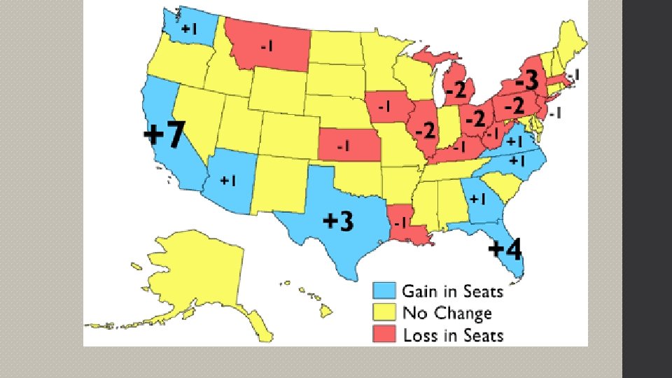
Congressional reapportionment
If Party A is in control of redistricting… • Wasted votes: Party B is a minority in every district • Excess votes: almost all of Party B supporters are in one district • Stacked votes: Party A controls the majority of districts, yet Party B controls more than 1 – can result in very strange shaped districts www. redistrictinggame. org
“Gerrymandering” Redistricting for partisan purposes; redrawing legislative districts for the purpose of benefitting the party in power, ex NC district 12…
A famous gerrymander
2016: Suggestion based on Federal Court
NC Voter registration
I 205 229 1
Change in Electoral Votes New York NC 1980 41 13 1990 33 14 2000 31 15 2010 30 15 Florida Texas California 17 26 45 25 32 54 27 34 55 28 37 55
Presidential Elections 2008 2004 2012
2008 Election
2004 Presidential Election
2012 Presidential Election
2012 Presidential Election
2012 Presidential Election
2012 Presidential Election
Patterns of local, regional, and metropolitan governance • Federalism Divides power between the central government and “local” governments allows strong power to units of local government within the country (the US), gives local people more power and representation can lead to tension due to regional/local representatives fighting for their own constituents
Patterns of local, regional, and metropolitan governance Unitary places power in the hands of the central government officials (Cuba) the local government cannot make its own decisions or repairs, must request and wait for answer from the central government local people have little voice
Local & Metropolitan Forms of Governance • Municipalities, school districts, regional planning commissions are subnational political units that have varying degrees of local control
… • Somali • Soviet woman voting repression • Catalonia • the wants independence Kurds would like a state